What follows is a short historical overview of the history and use of 37 Street SW in the community of Lakeview in Calgary. The road has a surprisingly long and interesting history, with a long tradition of First Nations, Military and Community use of the corridor since it was first set aside as a road.
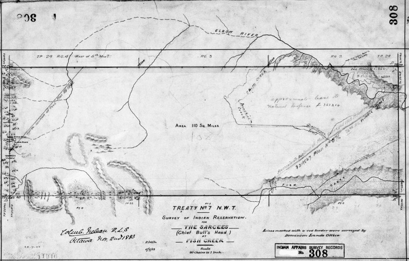
In 1883 the Tsuut’ina Nation reserve was first surveyed and reserved for the Nation, shown below.

The same year the adjacent township was surveyed, dividing up what is now SW Calgary. This survey laid out the 66-foot-wide 37 Street SW road allowance for the first time. The arrow on the survey below indicates the road.

When the reserve was first created, the Tsuut’ina Nation established a trail through the reserve to access Calgary at what is now 37 Street SW and Glenmore Trail. This route was part of a trail known as the Priddis Trail. The map below from 1897 shows this trail.

In 1900 the government formalized that trail into a highway through the reserve, and moved the reserve entrance to what is now the Weaselhead parking lot at 37 Street SW and 66 Avenue SW. Accessing the reserve meant traversing one mile of 37 Street. Below is a map from 1926 showing route of the Priddis Trail.

For a brief time in 1930 the Priddis Trail, including that portion of 37 Street SW, was earmarked as the route of Highway 22, before ultimately being built from Midnapore.
The Priddis Trail served the Nation and Calgarians for 58 years, until the bridge over the Elbow collapsed in 1958 (pictured below). Nation citizens had already been using the Military’s new bridge, which was constructed around 1950 over the Elbow river, and returned to using the old reserve entrance point at the intersection of Glenmore Trail and 37 Street SW.

The Military built several more roads in 1957-58 that connected to 37 Street SW to allow access to Military housing and a school on the west side of the road. At this point in time, access to the Military base, the Tsuut’ina Nation reserve and a cattle ranch are the primary uses of 37 Street SW, and construction of Lakeview had not yet been started. The map shown below is from 1960.

When planning for the new community of Lakeview began in 1959, the City of Calgary designated 37 Street SW as a ‘Major Thoroughfare’ and added 34 feet to the width of the road’s original corridor.

In 1960, construction began on the neighbourhood. The first houses were built on the east side of the community, near Crowchild Trail. Over the next decade construction moved west, closer to the newly-paved 37 Street SW, and the final phase of Lakeview’s original single-family homes were built in 1968-69. Below is a picture of Lakeview from the 1970s, looking west along 66th Avenue SW.

In 1970, after much of Lakeview is largely completed, traffic maps for the first time show traffic on 37 Street SW. About 5,000 cars per day are shown on the road near Glenmore Trail, with the numbers dwindling lower towards the south end of the road. The change of the road from rural right-of-way into suburban thoroughfare marks the most significant change in the use of 37 St SW in the history of the road. Traffic on 37 Street SW was at its peak in the 1970s, when Military use, Lakeview access, and users of North Glenmore Park constituted the majority of traffic. In the 1990s the Military base was closed, and traffic has declined overall since that time. The City of Calgary’s traffic map from 1970 is shown below.

In 1967 the City of Calgary had already planned for the 37 Street SW – Glenmore trail interchange to be a ‘diamond’ style interchange when conditions warranted it. The plan from the City of Calgary’s 1967 CALTS report is shown below.

In 2010 a new temporary interchange was built at 37 Street SW and Glenmore Trail. The interchange was designed so that the bridge over Glenmore Trail was located away from where a permanent interchange would eventually be built. This would allow the interchange to remain open while a new interchange was being constructed. The current interchange is shown below, looking towards the Southwest.

In 2013 the Province of Alberta and the Tsuut’ina Nation entered into an agreement to sell land for the Southwest Calgary Ring Road. This agreement guaranteed access to the Tsuut’ina Nation reserve at 37 Street SW and Glenmore Trail as part of the ring road project. If this access is not provided, the ownership of the entire ring road corridor through the reserve will revert back to the Nation. The design of the new permanent interchange is shown below.

The contract for construction of the ring road project including the new interchange at 37 Street SW and Glenmore Trail was awarded in 2016, and some initial earthworks has already begun. The interchange is set to open by 2021.
