
This month, the Government of Alberta revised the plans for the Southwest Calgary Ring Road Project by extending the western portion of the road into the Highway 8 corridor. This section of the ring road, what is currently Highway 8 from Sarcee trail to just west of the Calgary city limits and highlighted below in blue, had until recently been a part of the West Calgary Ring Road Project. This change shifts approximately 5km of roadway to the Southwest ring road, adds one additional interchange (69th street SW) and a new crossing over the Elbow River to the project, while removing the same from the West leg of the road.1
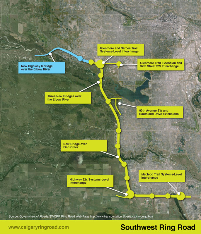 (The previous Southwest ring road route in green, with the addition of a portion of Highway 8 in blue, making up the most recent Southwest ring road alignment.2)
This section of Highway 8, between Sarcee trail and 101st street, has played an important role in the history of the ring road, not only recently, but for many years before.
South Morley Trail, Springbank Trail, Richmond Road and Highway 8
The modern Highway 8 partially follows the route of one of the oldest roads on Calgary’s west side. Richmond road, first known as South Morley Trail, was a key trail west of the city in the 19th century, and originally connected Calgary to the Stoney Nakoda First Nation Reserve via Springbank.3
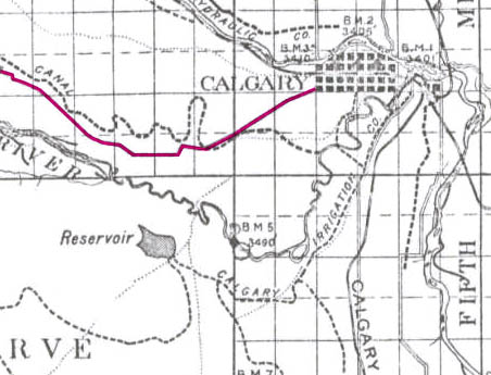 (The Richmond road corridor highlighted in pink, 1894.3)
From the City’s earliest days, Richmond road was one of Calgary’s few main routes to the west. By the early 20th century the route was also known as the Springbank trail beyond the city limits, due to the fact that it no longer connected directly to the Stoney reserve, and instead served the area of Springbank to the west of the city. Around this time a new branch of the road was created to connect with Bragg Creek, splitting south from Richmond road at 101st street, crossing the Elbow river at an area known as ‘Three bridges’, and on to Bragg Creek: this route is what is now known as Highway 8.4,5
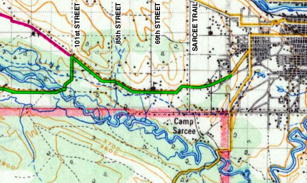 (Richmond road in 1926, highlighted in green. The road branches south towards Bragg Creek and the modern Highway 8 alignment from the path of the original road, highlighted in pink, at 101st street SW.5)
In the mid-1950s a long-range planning effort by the City of Calgary was created, which envisioned the original Richmond road alignment as a high-capacity trucking route, and even as a possible Trans-Canada Highway bypass.6
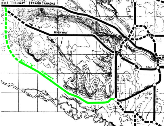 (Richmond road west of Sarcee trail, highlighted in green, envisioned as a south Calgary Trans-Canada Highway bypass, 1957.6)
These plans, however, would soon give way to an alternative route, and by the end of the 1950s the City would begin to favour a Glenmore Trail extension as the area’s primary westbound highway. Although Richmond road would be downgraded to a major road in subsequent studies, it would continue to be used as a Provincial highway and trucking route until the 1990s, as the Glenmore Trail extension would remain unbuilt for decades.
Growth, Development and Conflict
A growing city and residential development along Richmond road over the 30 years following the identification of a new highway route soon brought a once-rural road into conflict with city residents. In the early 1990s, developers began building the subdivision of Richmond Hill, west of Signal Hill and Sarcee trail. Numerous homes were built adjacent to the Richmond road corridor, including some that were located within only a dozen metres or so from the road. Once new homeowners began living near the route, concerns about traffic and noise began to emerge.7
As a temporary measure to quell these concerns, a restriction was implemented on Richmond road, prohibiting trucks from using the route on weekends and at night between 7pm and 7am. This restriction was reportedly supported by the trucking industry on condition that immediate measures were taken on the construction of the Glenmore Trail extension.
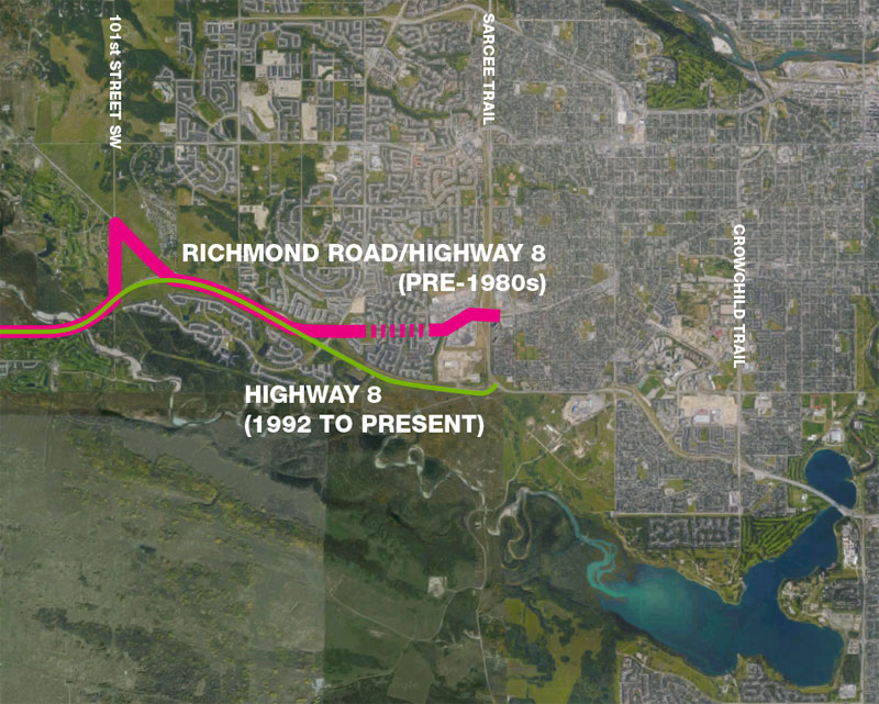 (Richmond road (Pink) and the new Highway 8 (Green). The dotted section shows the closure of the road after 1993.8)
The developer responsible for Richmond Hill, Markborough Properties, was convinced by local residents to advance part of the approximately $4 million that was required to extend Glenmore trail in order to relieve the busy Richmond road that ran through the community. A commitment of 25% of the construction costs as a loan from Markborough Properties ensured that the timing of the already-scheduled project would be moved forward, and in December of 1992, the 3km, 2-lane extension of Glenmore trail was opened to the public. The next year Richmond road was permanently closed to traffic between 69th street SW and Sierra Morena Blvd.
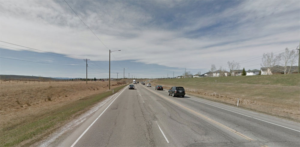 (Highway 8 looking west towards 69th street SW, April 2015. Source: Google Maps.)
Provincial representatives later noted that this new section of Highway 8 was the first new roadway to be constructed within the ring road corridor, and noted the road as one of the ‘Initial Ring Road Projects’ for Calgary.9
Highway 8 as a part of the Ring Road
When originally planned, the West portion of the ring road was planned along the Sarcee trail corridor south of the Bow river, and did not utilize the Highway 8 corridor. This changed when the plans for the Northwest ring road were altered in the mid 1970s, and its route was shifted west to the 101st street corridor. With a new Northwest ring road alignment came the need for a new West leg of the road, as well as a way to connect that leg to the previously planned Southwest ring road route.
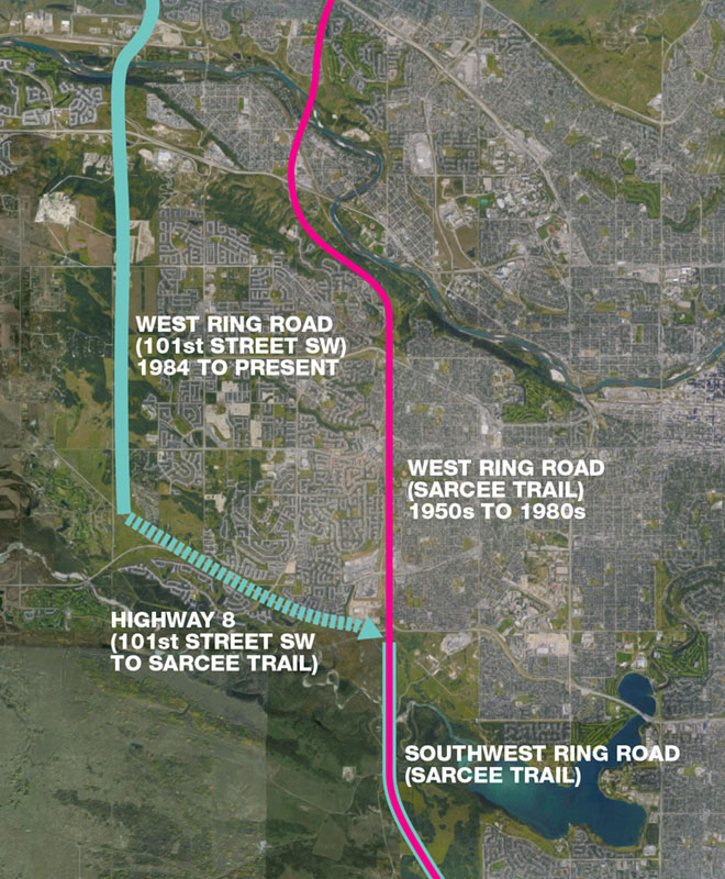 (Shown are the locations of the original west leg of the ring road along the Sarcee trail corridor, and the new West leg on 101st street SW, plus the missing portion between the two routes along the Highway 8 corridor.10)
In 1984, when the modern West leg of the ring road was first laid out, the road was shown to terminate at its intersection with Richmond road. At that time, the location of the Southwest ring road through or around the Tsuut’ina reserve had not been resolved. While it was understood that the ring road would almost certainly occupy part of the Highway 8 corridor in order to connect the West ring road leg to Sarcee trail, firm plans would not be drawn up until the Southwest ring road alignment was developed. Though this link was briefly shown in new Southwest ring road plans developed later in 1984, it was left off of much of the planning and evaluation for the rest of the ring road throughout the 1980s.
 (Glenmore Trail extension/Highway 8 portion of Stoney Trail, highlighted in green.11)
Attempts to advance the Southwest ring road faltered in the 1980s and 1990s, and the planning for Highway 8 as part of the ring road faltered along with it. It wasn’t until the Province took over the ring road project in the 2000s that more detailed planning was undertaken for this part of the road.
Modern Planning for Highway 8
Planning for the Highway 8 corridor as part of the ring road was undertaken between 2005-2008 as part of the Province’s Southwest Calgary Ring Road Functional Planning Study. As with the rest of the Southwest ring road, the portion of the road that lay along the Highway 8 corridor was designed to have eight core lanes of traffic, and included interchanges at Sarcee trail, Westhills Way, 69th street SW and at 101st street SW/Highway 8 itself. Also included was a median large enough to accommodate a further eight lanes if a regional, outer ring road were one day to be built.12
 (Highway 8 corridor planned as part of the Southwest Calgary Ring Road Project.12)
Planning for the West leg of the road was undertaken separately around the same time, with the route planned between Highway 8 and the Trans-Canada Highway along the 101st street SW corridor.
In early 2014 the Province made the decision to re-allocate the 5km, Highway 8 portion of the ring road from the Southwest leg of the road to the West Calgary Ring Road Project, and to construct the West leg first, ensuring the timely construction of this part of the road.13 Attaching the Highway 8 corridor to the West leg went some way towards balancing the sizes of the two projects, and splitting the two legs at the Highway 8 corridor meant that the Province could begin construction on the West leg before the Tsuut’ina land transfer had been completed.
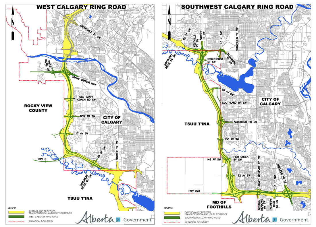 (Maps showing the split between the West and Southwest Calgary Ring Road Projects as of 2014.14)
Before the end of the year the Province revised the schedule of the remaining ring road projects, and the West leg was shuffled behind a newly prioritized Southwest leg. The proposed 2015 Budget further delayed the West leg of the road, and completion of that portion was envisaged to occur around 2025. The Highway 8 corridor continued to be attached to the now-delayed West leg for most of 2014 and into the following year, but by mid 2015, it would again be on the move.
New Government Announcement
On July 7 2015, Minister of Transportation Brian Mason, along with Tsuut’ina CEO Peter Manywounds, re-announced the Province’s commitment to construct and open the Southwest portion of the ring road within the agreed seven-year timeframe following the acquisition of land from the Tsuut’ina Nation. The announcement focused on the Southwest leg only, and no official update on the status of the West leg was made, with Mason instead stating “It’s not really something that any decisions have been made on as of yet”.15
Despite an announcement that might have meant the continued delay of the construction of the Highway 8 corridor as part of the ring road, changes to the remaining ring road projects had been made that would ensure the timely construction of this link. The day after Mason’s announcement, the Province released a request for qualification (RFQ) for contractors looking to bid on the Southwest leg of the road. This process, and a subsequent revision to the project description, detailed an updated Southwest ring road alignment that once again included the Highway 8 corridor and the interchange at 69th street SW; both of which have now been removed from the West Calgary Ring Road Project. According the Alberta Transportation this move was made to “accommodate a delay in the West Calgary Ring Road16“, while the timing for the West leg continues to remain unresolved.
It’s been over a century since the establishment of this route, and the Highway 8 corridor continues to be viewed as a key link on the City’s west side, as well as an integral part of Calgary’s ring road system. With the recent planning changes and commitments to build the Highway 8 corridor as part of the Southwest ring road, it appears that the construction of this road will soon be underway.
—–
With thanks to Carrie Sancartier.
—–
Sources:
1) Southwest Calgary Ring Road. http://www.transportation.alberta.ca/sw-crrgp.htm. West Calgary Ring Road. http://www.transportation.alberta.ca/w-crrgp.htm. Retrieved July 13 2015.
2) http://www.transportation.alberta.ca/sw-crrgp.htm. retrieved July 15 2015.
3) Preliminary map of a portion of the District of Alberta showing Canadian irrigation surveys during 1894. Ottawa: Department of the Interior, 1894. Peel’s Prairie Province, University of Alberta. Map 746)
4) “(Three Bridges) is reached by following the graveled road from Seventeenth avenue in Killarney subdivision… Following this road, which is the old Springbank trail, one takes the first graveled turning to the left after leaving the city limits, where the road branches for Bragg Creek some 20 miles west, and Three Bridges is at the foot of the hill where the Elbow flows through the valley.”
‘Many inviting places near Calgary where fresh waters and shady nooks offer rest’ Calgary Herald, June 2, 1934.
5) University of Alberta Peel’s Prairie Provinces archive, Map 17, 1926 XXXXXX
6) Traffic Survey. City of Calgary Archives. Board of Commissioners s.IV, Box 128, Traffic Survey 1957-1958, File 1 of 2.
7) ‘Glenmore extension will quell traffic noises’. Calgary Herald. June 27 1992.
8) Sources: University of Alberta Peel’s Prairie Provinces archive, Map 17, 1926 and Google Maps.
9) Calgary and Edmonton Transportation and Utility Corridors Presentation, ca. 1994. Province of Alberta representatives, personal collection.
10) Sources: Calgary Transportation/Utility Corridor Reassessment, 1985. A Multi-Disciplinary Evaluation of the Calgary Parkway Ring, 1974. Google Maps.
11) Sarcee Trail Planning Study, 1984. Province of Alberta, City of Calgary. Tsuut’ina Nation.
12) Southwest Calgary ring road (Highway 201) – Functional Planning Study, Glenmore Trail / Stoney Trail Interchange to Highway 22X / Sarcee Trail Interchange, 2008. Alberta Transportation.
13) Southwest and West Calgary Ring Road Projects. http://www.transportation.alberta.ca/4043.htm. Retrieved March 10 2014.
14) West Calgary Ring Road Project General Overview Plan and Southwest Calgary Ring Road General Overview Plan. http://www.transportation.alberta.ca/Content/docType5575/Production/w-crrgm.pdf and http://www.transportation.alberta.ca/Content/docType5574/Production/sw-crrgm.pdf. Retrieved May 15 2014.
15) ‘Province updates status on long-awaited southwest ring road.’ James Woods. Calgary Herald. July 7 2015.
16) Personal correspondence with Alberta Transportation. July 22 2015.

Do you think this implies that the Alberta Government is now actively considering using a twinned Highway 22 from the TCH southward to Highway 8 as an interim west leg of the Ring Road at a much lower cost than the actual west leg of Stoney Trail south through Paskapoo slopes?
I haven’t heard of any plan to use that configuration of roads as a ring road alternative, and I suspect it is not being considered as part of this scheme.