2016 SW Ring Road Open Houses

KGL Constructors, the subcontractor responsible for the design and construction of the Southwest Calgary Ring Road, will be leading three open house sessions this month. Representatives from KGL, Alberta Transportation, and the City of Calgary will be on hand to present information about the project, and to answer questions about the progress and schedule of construction.

swcrr-schedule18-appa-36

2016 SOUTHWEST CALGARY RING ROAD INFORMATION SESSIONS:

Monday, November 28 (South Glenmore)
5:00-8:00 p.m.
Oakridge Community Hall, 9504 Oakfield Drive S.W.
View Google Map

Tuesday, November 29 (North Glenmore)
5:00-8:00 p.m.
Calgary First Church of the Nazarene, 65 Richard Way S.W.
View Google Map

Wednesday, November 30 (Deep South)
6:00-9:00 p.m.
Bishop O’Byrne High School, 333 Shawville Boulevard S.E.
View Google Map


SW Ring Road Work Set To Begin

Update September 15 2016: A $1.42 billion contract (adjusted to 2016 dollars) has been signed between the Province of Alberta and Mountain View Partners for the construction of the Southwest Calgary Ring Road project. Click here for details.


Mountain View Partners have been selected to begin initial work on the Southwest Calgary Ring Road project under an interim agreement. While the full contract will not be entered into until September 13, this interim agreement will allow work to begin along the road corridor, including the relocation of utilities. The Alberta Government expects to see crews and equipment on the project site by mid-July.

Mountain View Partners is a consortium consisting of:

  • Project Lead:  Meridiam Infrastructure North America Fund II, as managed by Meridiam Infrastructure North America Corp.
  • Financing Lead:  Meridiam Infrastructure North America Fund II, as managed by Meridiam Infrastructure North America Corp.
  • Design-Construction Lead:  Kiewit Management Co.
  • Operation and Maintenance Lead:  Alberta Highway Services Ltd.


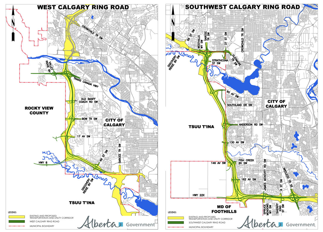
Click Here for maps of the full Southwest Calgary Ring Road Project.


Source: “Southwest Calgary Ring Road construction begins” July 8 2016. Government of Alberta.

The Rise and Fall of the Priddis Trail – Part 2: A Road In Use

This is the second in a five-part series looking at the history of the Priddis Trail. The first part, which examined the establishment of the road can be found here, and part three can be found here. I acknowledge that the resources that inform this work are largely that of non-First Nations sources, and while this is intended to be a factual look at the history of the road, it must be noted that the perspective is largely non-indigenous. I hope that further research and working with Tsuut’ina sources will reveal other equally valid perspectives on this story in the future.

—–

From Governor-Generals, Tsuut’ina Chiefs and Colonels, to Ranchers, Homesteaders and Boy Scouts, the Priddis Trail was important to a great many people for a great number of reasons. The establishment of the Tsuut’ina reserve and an early influx of Homesteaders in the late 1800s, followed not long after by the Military and a growing oil industry, meant that reliable access to a growing district was vital to the region.

map-pt-only(Map of the route between Calgary and Millarville through the Tsuut’ina Reserve in 1899. Source: ‘Plan Shewing survey of Old Trail and New Road from N.E. Cor. Sarcee Indian Reserve to Millarville P.O.’ A. P. Patrick. 1899. Plan 1119i, Alberta Land Titles, Southern Alberta Land Registration District )

BEFORE THE HIGHWAY, A TRAIL

When first formed, the route that would become the Priddis Trail was a modest dirt track used by members of the Tsuut’ina Nation and by Homesteaders living in the Priddis and Millarville districts of Alberta. Suitable for horse-and-wagon travel, the trail provided a much needed connection between these southern areas and Fort Calgary, including the burgeoning town that had begun to grow around it. In its earliest days, the land that the trail passed through had not yet been designated as the Tsuut’ina reserve1, and when the reserve was established in 1883, the use of the trail continued unabated by Tsuut’ina members and non-Indigenous settlers alike.
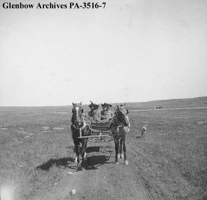
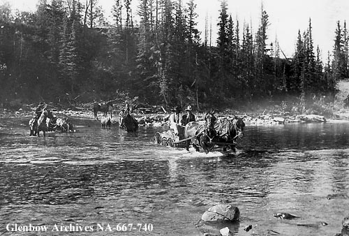
pa-3516-7(‘Group of visitors in wagon on the way to Sarcee (Tsuu T’ina) reserve, Alberta.’ Glenbow Archives PA-3516-7. ca. 1899)

The earliest record of the Priddis Trail comes not from the path itself, but of the trail’s crossing of the Elbow river, known as the ‘Weasel Head Crossing’. In December of 1890 a newspaper article noted the Weasel Head Crossing as the site of the butchering of stolen cattle,2 making this the first mention, albeit indirectly, of both the trail and of the ‘Weaselhead’ name that this part of the Elbow river valley would later become known by.

By 1894 the first map of the route was made by the Department of the Interior3, and soon the trail was showing up regularly in newspaper accounts and official documents. In response to questions about the trail in 1899, the acting Agent of the Sarcee Agency stated: “(Chief Bull Head) informed me the trail marked in the plan was in use by the Indians before the treaty was made with them.”4, an indication of the long use of this important connection.

PriddisTrail_1897(A map from 1897 [with added highlights] showing the route of the Priddis Trail. Source: “Preliminary map of a portion of the District of Alberta showing Canadian irrigation surveys during 1894″. University of Alberta Libraries, Peel Map 747.)

For users of the road, whether Nation members or Homesteaders, the trail enabled sustainability and economic activity by providing access to the marketplaces of Calgary. In 1893, for instance, a “comfortable dwelling house, with a good stable and corral” was built at the Weasel Head Crossing so that Tsuut’ina members had a place to stay when harvesting timber destined for sale in the City5. Former Tsuut’ina Nation Chief Sanford Big Plume also noted the use of the old trail in the Nation’s economic and cultural activities: “In the late 1800s… Once a year, Foxtail would cut small evergreens, load them on a wagon led by horses, and drive them down the Priddis Trail to Fort Calgary. There, they were sold as Christmas trees. With the proceeds of those trees, Foxtail would help fund a meal for our people, so we could also celebrate Christmas.”6

In a similar way, Homesteaders relied on the trail to bring produce and stock to market, and to access the services that the City offered.
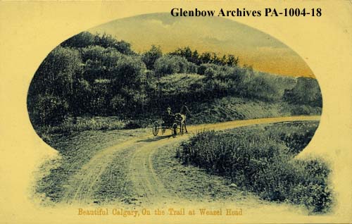
pa-1004-18(Postcard showing a wagon on the Priddis Trail. ‘Weaselhead district, Calgary, Alberta.’ Glenbow Archive PA-1004-18. ca. 1908.)

Besides being functional, the trail was also noted to offer access to some of the more beautiful country in the area, and the use of the trail for pleasure would increase in popularity over the years. In the summer of 1895 the Governor-General of Canada Lord Aberdeen was touring the country, and by the summer of that year he had arrived in Calgary. On a morning in August, Lord and Lady Aberdeen were driven in the vice-regal carriage to a meeting with members of the Tsuut’ina Nation via the trail; the journey having been noted in the Calgary Daily Herald as “one of the prettiest drives in the N.W.T.”7. Forty years later, noted homesteader A.M. Stewart mirrored that sentiment in stating “…this road constitutes about the prettiest drive out of Calgary.”8 and the route was included in maps of automobile pleasure tours for the Calgary region.9

The still-nameless trail was increasingly well-used, and this usage would soon outstrip the ability of the trail to comfortably accommodate the traffic. By the end of the 1890s, muddy conditions on the primitive trail, ruts caused by wagon wheels and a lack of a bridge over the Elbow river would cause problems for travelers looking for unimpeded access. The un-maintained dirt track was proving to no longer be suitable for the use it was expected to accommodate, and Homesteaders living in the area soon lobbied to correct the situation. Continue reading “The Rise and Fall of the Priddis Trail – Part 2: A Road In Use”

The Origins of the Southwest Ring Road

This article was originally published on April 15 2015. It was updated on March 5 2016 to reflect newly found information about the City’s earliest plans for bypass routes in 1952 and 1953.

The City of Calgary and the Province of Alberta variously point to planning and studies from 1959 or the 1970s as the origin of the Southwest Ring Road.1 While these studies mark important milestones in the history of this road, particularly around planning for the current iteration, the truth is that the concept is a much older one than that.

1953_township

(Township plan of Bowness, Mongomery, and what would eventually become west Calgary, 1953)

Early efforts had been undertaken to plan for roads encircling Calgary’s downtown area, notably the town plan by Thomas Mawson in 1914, though these were not acted upon at the time. It wasn’t until a post-world war two explosion in population growth and vehicle ownership in Calgary had occurred that the issue of bypass roads would again be brought to the fore.

The 11-year period between 1952 and 1963 constitute the practical origin of Calgary’s bypass road system, and would see incredible effort and progress on this issue: from outright rejection, to intensive planning, and finally to construction of Calgary’s first southwest bypass route.

The Earliest Southwest Ring Road Plans

In order to address the rapid growth experienced in the post-war years, the City of Calgary began the process of creating a General Plan for the city in the late 1940s. By 1951, an interim report on the General Plan was produced, which included descriptions of primary roads planned for Calgary. A major route following 50th avenue SW across the Elbow river along the City’s southern edge and 14th street SW heading north across the Bow river2 was noted, and was intended to connect the Macleod and Banff trails and act as a bypass around the City’s core.

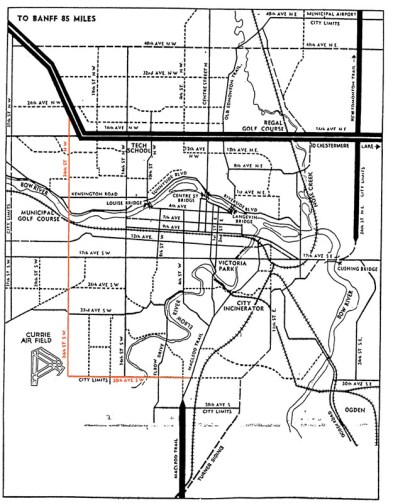
This interim report was followed by a preliminary major roads plan that was presented to City Council in the winter of 1952. The plan contained many of the same routes as the earlier General Plan interim report, though the southwest bypass was now envisioned along 24th street SW/Crowchild Trail, rather that 14th street SW, as the north-south portion of the route.3

1952-road-highlight

(A depiction of Calgary’s Major Roads Plan as presented to City Council. Source: Traffic Problem Solution Seen. Nigel Dunn. Calgary Herald. December 19, 1952. Highlight added.)

Although these initial planning efforts focused on routes contained within the City’s limits, plans were simultaneously being prepared on a wider scale; the City’s major road plan was not intended as a final document, but was intended to be continually updated and expanded as conditions demanded.

The City’s planning department had earlier drafted a different map in 1952 that for the first time described the series of planned bypass roads as a ‘Ring Road System’, and indicates, though does not fully depict, a southwest bypass located on 37th street SW.4 This was an internal working document that was not intended for the public, and shows how the City had begun to look outside of it’s city limits at more regional roads.

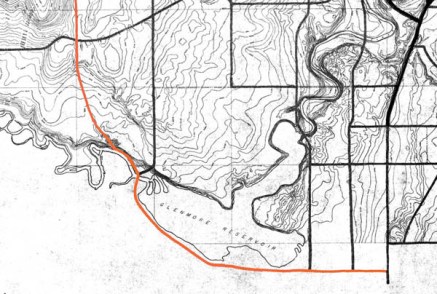
In late 1953 a further revision was completed, which for the first time fully detailed a Southwest Ring Road route around the west edge of the Glenmore reservoir.Comprising of 90th avenue SW on the south and 53rd street SW/Sarcee Trail on the west, this version of the Southwest Ring Road shares little in common with the modern route, though the use of the Sarcee Trail right-of-way and a crossing through the Weaselhead would remain part of the Southwest Ring Road plans for decades to follow.

1953-highlight

(Source: Untitled Map. December 1953. City of Calgary Corporate Records, Archives. Board of Commissioners S. IV box 189 F. 39.)

By the early 1950s the City had a defined, though extremely fluid, ring road plan. Work on the plan by the City of Calgary would continue for a number of years yet, though putting the scheme into action could not be done by the City alone; implementation would require a partner in the form of the Provincial government.

Continue reading “The Origins of the Southwest Ring Road”

Federal Funding Announcement

On Thursday July 30 2015, Federal Minister for National Defence and Multiculturalism Jason Kenney, along with Alberta Minister for Transportation Brian Mason, announced Federal funding for the Southwest Calgary Ring Road project.

At the announcement, also attended by Tsuut’ina Chief Roy Whitney-Onespot, Kenney detailed a commitment of $582.9 million, which represents one quarter of the estimated $2.8 billion cost for construction of this leg of the road. The funds are being earmarked from the National Infrastructure Component of the New Building Canada Fund, which ‘provides funding for projects of national significance’1.

July_2015_update_new

(Map showing the newly revised route of the Southwest ring road; from Macleod trail in the south, to west of 101st street SW in the west.)

Continue reading “Federal Funding Announcement”

Highway 8 and the Ring Road

This month, the Government of Alberta revised the plans for the Southwest Calgary Ring Road Project by extending the western portion of the road into the Highway 8 corridor. This section of the ring road, what is currently Highway 8 from Sarcee trail to just west of the Calgary city limits and highlighted below in blue, had until recently been a part of the West Calgary Ring Road Project. This change shifts approximately 5km of roadway to the Southwest ring road, adds one additional interchange (69th street SW) and a new crossing over the Elbow River to the project, while removing the same from the West leg of the road.1

July_2015_update_new(The previous Southwest ring road route in green, with the addition of a portion of Highway 8 in blue, making up the most recent Southwest ring road alignment.2)

This section of Highway 8, between Sarcee trail and 101st street, has played an important role in the history of the ring road, not only recently, but for many years before.

South Morley Trail, Springbank Trail, Richmond Road and Highway 8

The modern Highway 8 partially follows the route of one of the oldest roads on Calgary’s west side. Richmond road, first known as South Morley Trail, was a key trail west of the city in the 19th century, and originally connected Calgary to the Stoney Nakoda First Nation Reserve via Springbank.3

1894_Richmond_Road(The Richmond road corridor highlighted in pink, 1894.3)
Continue reading “Highway 8 and the Ring Road”

SW Ring Road Land Transfer Approved

On May 1 2015 the Privy Council of Canada passed order 2015-0556, which authorizes the transfer of the proposed Southwest Ring Road corridor to the Province of Alberta. The same day, the Council passed a separate order, 2015-0557, which adds and incorporates former Alberta Crown lands into the Tsuut’ina reserve. With these two documents the land acquisition required for the Southwest Calgary Ring Road is approved.

The Province transferred $275,000,000 to the federal government in April of this year. The payment for the land will only be forwarded to the Tsuut’ina Nation, and the land title will only be assigned to the Province, once the Federal Minister of Aboriginal Affairs and Northern Development Canada signs off on the transfer.

reserve_overall_1
(Source: Canada Lands Survey Records (CLSR) 103661 January 21, 2015 and CLSR 103574-1 December 17, 2014. Image: Google Maps)

The Image above shows the new boundaries of the Tsuut’ina reserve. The original reserve (created in 1883) is shown in blue, while the newly added land (2015) is shown in magenta. The Weaselhead (1931), the Highway 22 corridor (1957) and the Southwest Ring Road corridor (2015) have been removed from the original reserve.

Moving Forward

The 2013 referendum of Tsuut’ina members, and the subsequent ratification of the agreement, meant that the Nation approved the sale and exchange of lands in order for the Province to acquire the corridor needed to build the Southwest Calgary Ring Road. Over the past 18 months, both the Province and the Nation have worked to fulfill their obligations under the agreement, in order to ensure that the land transfers would be approved by the Federal Government. Once the transfer has been enacted, which provincial representatives expect soon, the Province will have seven years in which to construct the road.

The commitment to construct the road was recently reaffirmed by former Premier Jim Prentice in the Progressive Conservative’s 2015 Provincial Budget, with construction of this leg of the ring road planned to begin as early as 2016. Though a new government is now in place, a finalized transfer of the corridor will oblige the Province to construct the road as agreed, or face the loss of the land and the money already paid.

Premier-designate Rachel Notley did not take a definitive stance on the Calgary Ring Road in the course of the 2015 election campaign, though she is quoted in relation to the ring road project as saying “In principle we are adopting the capital funding envelope and the vast majority of the commitments that the [Progressive] Conservatives have already adopted so you’d see us being in line with what’s already in the budget.” (Calgary Herald, April 29 2015, ‘Wildrose Leader Brian Jean promises to finish Calgary ring road by 2021′)

Continue reading “SW Ring Road Land Transfer Approved”

Budget 2015 and the Ring Road

Yesterday the Alberta government announced details of the proposed budget for 2015, which includes information about the two remaining portions of the Calgary Ring Road. As a cost-cutting measure, the West Calgary Ring Road is being delayed by four years, and construction is now slated to begin in 2020/2021. Expected completion of this leg, and ultimately the entire ring road, will not occur until 2024/2025, and the measure is expected to defer a reported $1.5 billion from the current budget time-frame. W&SW_Ring_Road The Southwest Calgary Ring Road, the portion that runs through the Tsuut’ina Nation reserve, remains unaffected. Work will begin on this leg of the road once the Tsuut’ina land transfer has been approved and once a contract has been tendered and awarded, with construction expected to begin next year. The agreement signed between the Nation and the Province in 2013 commits the Province to open the Southwest portion of the road within 7 years of the land transfer, and the opening is estimated to occur in 2020. The 2015 budget allocates $2.9 billion over the next 5 years towards the construction of Alberta’s ring roads. This figure includes funds needed to complete Edmonton’s Anthony Henday Drive as well as beginning work on the Southwest Calgary Ring Road (interestingly referred to as ‘Southwest Stoney Trail’ in the Province’s 5-year Capital Plan despite a promised name change as the road crosses through former Tsuut’ina reserve lands).

Utility relocation open house

Today, February 24 2015, the Government of Alberta is hosting its latest ring road public information session. The focus will be on the relocation of utilities in preparation of the Southwest Calgary Ring Road project.

In addition to Alberta Transportation and the City of Calgary (who will be presenting the City’s proposed ring road connections and the 37th street SW storm trunk relocation) there will be representatives from AltaLink, ENMAX, ATCO and the Alberta Utilities Commission who will be available to answer questions.

Tuesday, February 24 2015
4 – 8 p.m.
Glamorgan Community Association, 4207 41 ave SW
View Google Map

Storm Trunk Relocation: The first steps to the SW Ring Road

In June of 2015, the City of Calgary will begin to construct some of the first tangible work on the Southwest Calgary Ring Road Project. This work will not be on the road itself, but will be related to utilities that will run under part of the project.

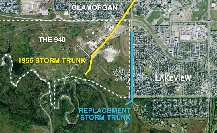
The City and Province of Alberta has agreed to construct a new storm sewer line to replace the existing South Richmond Storm Trunk that currently crosses a portion of the Tsuut’ina Nation reserve known as ‘the 940‘. The new line will be located entirely within the City of Calgary city limits along 37th street SW in Lakeview when completed, while the old line will be abandoned. This abandonment and replacement is not due to the functionality or suitability of the existing infrastructure, rather it is necessary due to reasons that are political and jurisdictional in nature; reasons that go back more than 60 years.

stormtrunk_b

Continue reading “Storm Trunk Relocation: The first steps to the SW Ring Road”