
Though the route of the southwest ring road through the Tsuut’ina reserve has in recent years garnered the most attention of the unfinished portions of Calgary’s bypass network, there are actually two additional pieces of infrastructure needed to complete the ring. Aside from the south leg, which extends the road to Macleod Trail in the south, there is also the West Calgary Ring Road, defined as the portion of the road that connects the Trans Canada Highway to Highway 8. This is the piece that I will cover here.
Early West Side Planning

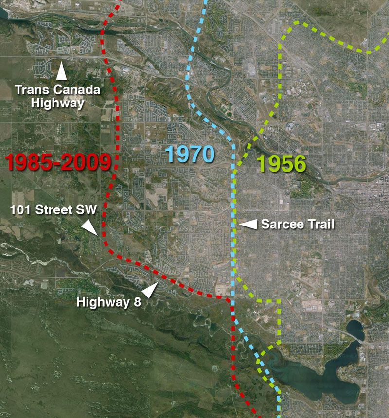
The earliest complete plans for a ring road around Calgary, dating from 1956, plotted much of the western leg of the circuit along the 53rd street SW corridor, better known today as Sarcee Trail. While the route to the north and south of this leg would undergo revisions, this western portion would remain largely unchanged for nearly 30 years, and the road would continue to be planned along the Sarcee Trail corridor until the mid 1980s.
Stoney Trail Extension
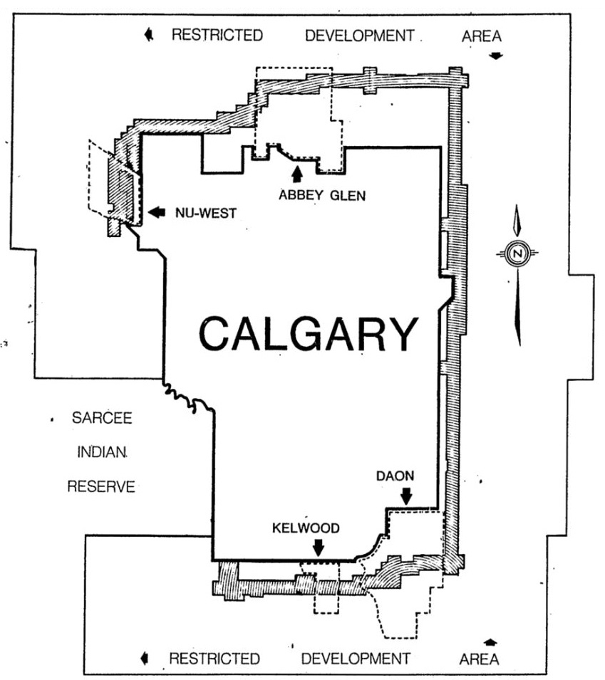
In order to assist with the long-term planning required for the ring road, the Province of Alberta had begun to protect a transportation corridor with the creation of a Restricted Development Area (RDA) around Calgary in 1976. Although this protection included land along the west side of the City, the proposed Transportation Utility Corridor did not extend south of the Trans Canada Highway (near the notation for the ‘Nu-West’ annexation, noted in the map below).
By the mid-1970s, the City had begun to endorse an alignment for the northwest portion of the ring road that was located west of the city limits. This proposed route essentially terminated at the Trans Canada Highway, and did not include a direct southward extension. The ring road plan at that time continued to rely on Sarcee Trail to carry traffic through the western and southern parts of the city, and as Sarcee Trail was located within the City limits, it was not subject to the Provincial RDA.
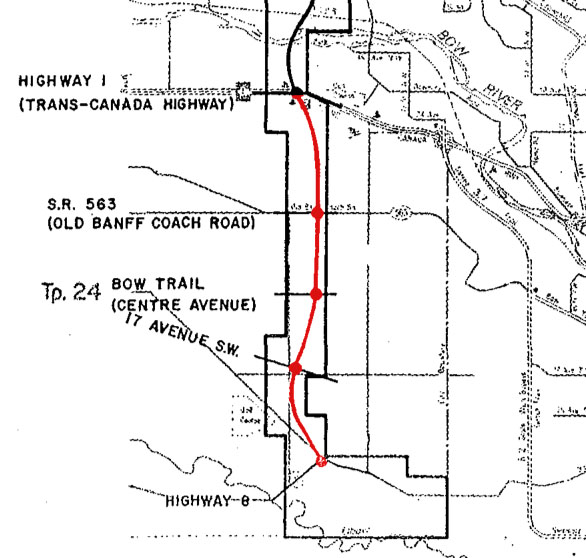
In 1984 the Province would alter these plans by extending their Transportation Utility Corridor south to Highway 8 and creating a distinct route for the west ring road; a true extension of Stoney Trail south of the Trans Canada Highway (shown in red below). This extension was located roughly along the 101st street SW corridor and remains the proposed location of the West Calgary Ring Road project today.
Adjacent Communities
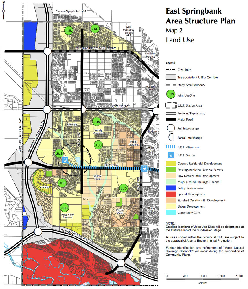
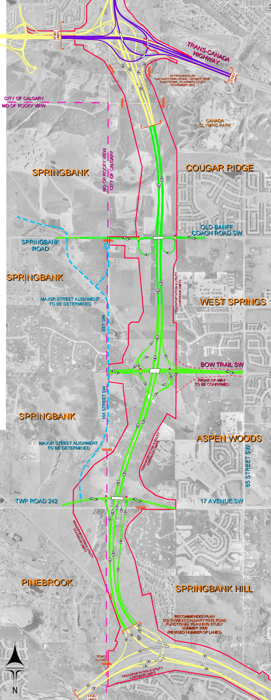
In the years since the selection of a route for the west ring road, a number of communities have been built adjacent to the Province’s Transportation Utility Corridor. The communities of Cougar Ridge, West Springs, Aspen Woods, Springbank Hill and Discovery Ridge were initially planned and approved between 1997 and 2000 as part of the City of Calgary’s East Springbank Area Structure Plan. These neighbourhoods were designed to accommodate the future ring road (shown below), while the existing transportation corridor helped shape these communities and the surrounding road network.
Designing the West Calgary Ring Road
In June of 2008 the Province unveiled the proposed plan for the West Calgary Ring Road project. Having earlier commissioned TransTech Focus to begin the process of designing this road, the Province held a series of open houses in 2008 and 2009 to present and seek feedback on the plans.
 (Click on the map for a larger version)
The recommended alignment, presented in June 2009 and shown above, begins at the current Stoney Trail interchange with the Trans Canada Highway, where it then heads south for about 7 kilometres in the vicinity of the 101st street SW corridor. The plan includes interchanges on Old Banff Coach Road, Bow Trail and 17th Avenue SW before becoming the southwest ring road along Highway 8.
Because of the desired integration with the southwest portion of the road, Provincial representatives noted that the west ring road would only be undertaken when the southwest portion was also ready to be built. “The intersection at Glenmore Trail is designed to accommodate the southwest ring road, so that deal will have to get done first.” stated Garry Lamb, Urban Construction Manager at Alberta Transportation, in 2008.
The planned southwest leg of the road, and thus the west leg by extension, would rely on the approval of the Tsuut’ina. Hopes were high that a deal between the Nation and the Province would be made, and that both legs could be developed together for a targeted completion date of 2015.
The push to build the road
Following the rejection of the southwest ring road deal by the Tsuut’ina Nation in 2009, calls were made, by Calgary’s Mayor Dave Bronconnier among others, to press ahead with the construction of the west ring road anyway. Unlike the southwest portion, the corridor for the west leg was controlled and largely owned by the Province, which meant that the possibility existed of constructing the west leg while alternatives were being sought for the southwest portion of the road.
Although in 2010 there was some speculation by then-Transportation Minister Luc Ouellette that completing the west portion of the road could be considered before the final alignment of the southwest ring road had been determined, there were factors seemingly preventing the construction the west ring road first.
In addition to wanting certainty over the southwest ring road in order to design an appropriate interchange between the two sections of the road, the perceived value of a stand-alone west ring road would become another sticking point to its construction. In the fall of 2012 Garry Lamb stated that the west leg of the ring road would be particularly expensive to build, owing in part to the large amount of earthmoving required to extend Stoney Trail up the Paskapoo Slopes, south of the Stoney Trail/Trans Canada Highway interchange. While the cost could be justified once the west ring road was also carrying traffic from the deep south, until the southwest portion was constructed, the more limited utility of a stand-alone west ring road would not likely be worth the cost. It seemed that without the southwest ring road in some form, the western leg would remain unbuilt.
Though alternative routes were studied for the southwest ring road that would have avoided the Tsuut’ina reserve, these were eventually put on hold pending further discussions with the Nation.
Deal Agreed
In October of 2013, a second referendum of members of the Tsuut’ina Nation ratified a new ring road deal with the Province of Alberta. This agreement, which allows the Province to construct the southwest ring road through the Tsuut’ina reserve, does not directly address the west ring road, but it’s approval has had the side effect of essentially green-lighting the western portion as well. At the press conference announcing the approval of the agreement, then-Transportation Minister Ric McIver stated that the Province would not only move ahead with the Tsuut’ina portion of the road, but would also seek to build the West and South Ring Road projects at the same time. The final portions of Calgary’s unfinished ring road, including the West Ring Road Project, now look more certain than ever to be on the road to completion.

Curious as to whether there is any opportunity to quarry sandstone in the trench that will be dug up the Paskapoo slope. If there is any useful sandstone it would seem a waste to simply blow-up & dispose, especially considering that sandstone from that area is used in so many significant (and mostly government) buildings in Alberta.
Click to access OFR_2010_01.PDF
Great job on the website – you are definitely an authority on transportation in Calgary.
I haven’t heard about any plans regarding the excess material from this project, though I would hope that any usable stone would be saved. It would seem to be a good opportunity to collect a building material that has such a rich history in this city.
Thanks for the comment!
I heard today that the west ring road work had been tendered and won by a contractor. I question the accuracy of the information and wonder if you have any comments on this? Thanks.
I have yet to hear about the tendering or awarding of the west ring road contract at this point. If I hear anything substantial, I will post back. Thanks!
According to Alberta Transportation’s website, as long as a Public Private Partnership process is approved by the Government, they would be looking to issue a Request for Qualifications shortly, and then appoint a contractor by Spring of 2015 for the west leg of the ring road. Hope this answers your question!
Is there a timeline in place for the Stony Trail/Old Baff Coach Rd interchange?
Currently the Province is currently looking to have the work for the West Ring Road contracted by this time next year. If construction takes place quickly after that, I suspect that the road could be completed in three to four years from that time.
I think you mean the 53rd Street S.W. alignment NOT 53rd Avenue.
You are correct, thank you for catching that.
when is the last section to begin construction.
According to the last statements by the Province, the West leg will not begin construction until about 2021, to be completed in 2024/25. There is a possibility that this could change as costs become known on the Southwest leg.
which is the West leg? Is this the Aspen/Wentworth/ Cougar Ridge area?
That’s correct, the portion between Highway 8 in the south and the Trans-Canada Highway in the north. Aspen, Cougar Ridge etc. are located just east of this portion of the ring road.