
This is the third post regarding the role of 37th street in the ring road story. Part 1, Glenmore trail to 66th avenue SW, and Part 2, 90th avenue SW to Anderson road can be found here. This third part covers the 37th street corridor between Anderson road and Highway 22x.
The Early Road
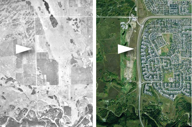
Located at the dividing line between the Tsuu T’ina Nation and the City of Calgary, it is natural that a road would emerge along the 37th street SW corridor. Marking the edge of Township 23, Range 1 West of the 5th Meridian, a road right-of-way had been established with the creation of the township land system for Alberta, though it wasn’t until later that a road was permanently established.
The Canadian Bridge Company of Walkerville Ontario was contracted to build an 80-foot ‘pony truss’ span across the Fish Creek, in order to serve what would eventually be called 37th street. At 16 feet wide, the bridge would be used as a crossing for nearly a century, first for horse and wagon traffic, and later as a one-lane bridge for cars. Thought the city reports that the bridge was built in 1907, Provincial and Federal documents around that time seem to contradict this assertion, and it’s true age currently remains unclear.
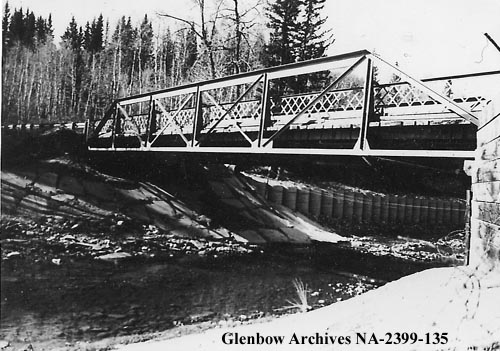
(Glenbow Archives NA-2399-135)
Built for the Provincial Department of Public Works and officially called the ‘Bridge at 37th St. SW & Fish Creek’, the bridge has also been referred to as the ‘Mannix Bridge’ due to its proximity to the old estate of Calgary businessman Fred Mannix, formerly located in the Fish Creek area.
Being one of only two road crossings of the Fish Creek park prior to the park’s establishment, 37th street would come to play a major role in the development of the Midnapore area and in the story of the southwest ring road.
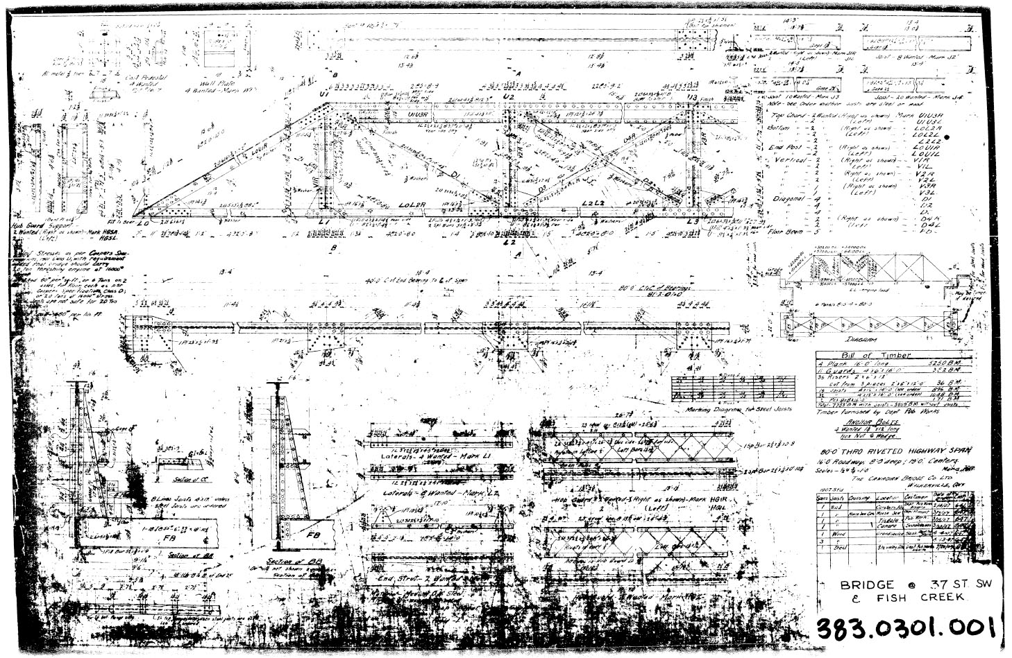
(Plans courtesy of the City of Calgary)
Long Range Plans
Early city plans of the 1950s showed the West Bypass (later known as Sarcee trail and then the southwest ring road) heading south from the reservoir along 37th street, but only as far as Anderson road, where it then headed east to Macleod Trail. The City’s first detailed transportation plan, the Calgary Metropolitan Area Transportation Study of 1959, alluded to a further southern extension of 37th street as a major roadway, though it offered no details of the road in this location. The Fish Creek crossing and the existing road were not a part of long-range planning by the City or Province until the emergence of the 1963 Calgary General Plan.
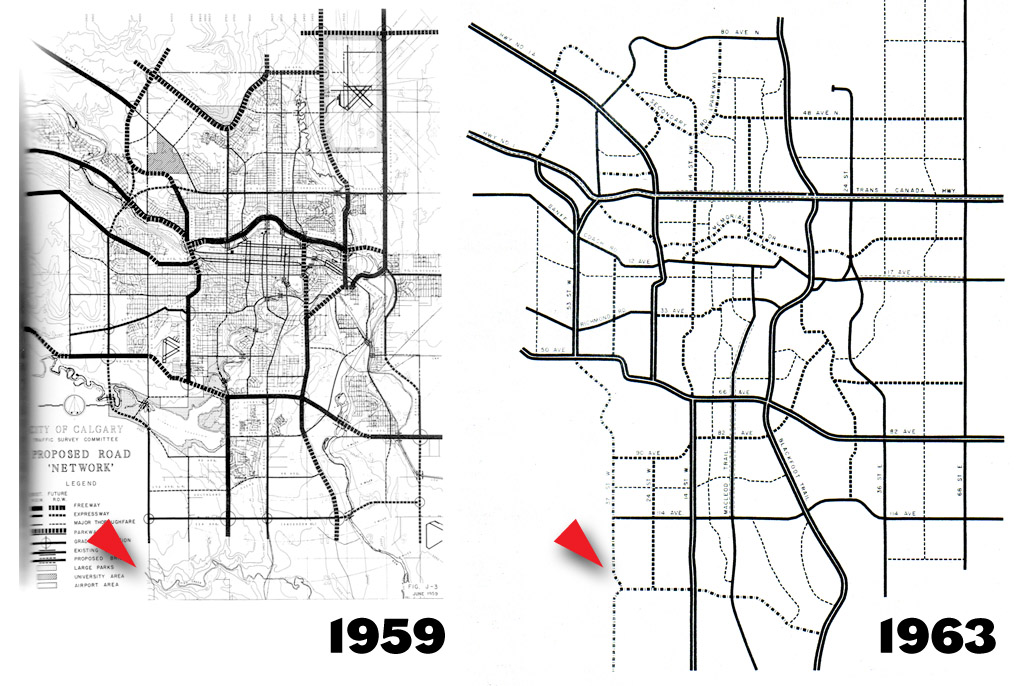
The General Plan of 1963 included a major thoroughfare plan that detailed the primary and secondary roads envisaged for Calgary over a 20 year timeframe. Part of that plan included the extension of 37th street south of Anderson road in order to connect to the areas south of Fish Creek. This route would eventually form part of the plans for the southwest Calgary ring road.
A Detailed Study of the Corridor
In 1974 the City of Calgary approved the development plans for the area south of Fish Creek known as Midnapore. In approving the plan, the City recognised that the limited transportation infrastructure in the area necessitated a phased approach to development. Phase 1 could proceed with upgrades to MacLeod Trail, Phase 2 could start once the Deerfoot trail was extended south of Fish Creek, and Phase 3 (officially known as Phase III) would only be approved for development once Sarcee trail was extended south of the reservoir and over Fish Creek along the 37th street corridor. In the 1970s, the Province had ruled out any further crossings of the Fish Creek Provincial Park, leaving Macleod trail and 37th street as the only roads to cross Fish Creek between Midnapore and the north.
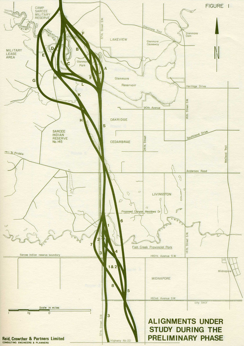
The approval of the Midnapore plan triggered a study for the location of the road, known as the Sarcee Trail South Route Location Study, which was published in 1977. Although much of this study focused on the crossing of the Elbow River near (or in) the Weaselhead, this document also studied the location of the proposed Fish Creek crossing. While a decision on crossing the Elbow River would be deferred for further study, the Fish Creek crossing was decided upon, and the chosen location has been adhered to in all plans and construction since that time. The map below details the available options, and the eventually selected Route 5.
An Old Road in Modern Times
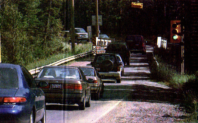
The steady growth in the Midnapore area meant that the use of the old 37th Street bridge was increasing, and soon the infrastructure would fail to satisfy the needs of the booming population south of Fish Creek. By the mid 1990s the bridge was seeing upwards of 7,000 vehicle crossings per day, and the uncontrolled one-lane nature of the bridge, combined with the inclines and limited visibility of the approaches, meant that the crossing had begun to see an increase of accidents. In early 1996 there were calls for the City to install traffic lights to better control the movement of cars crossing the bridge, though the City noted that there was no funds allocated for such improvements in the budget. It wasn’t until March of that year, after the fifth head-on collision at the bridge over the previous year or so, that a commitment was made to install a set of lights (pictured below).
Of course the installation of traffic lights was only a temporary solution to immediate safety concerns; the narrow bridge and existing 2-lane road had been earmarked for much more significant upgrades, though budgetary concerns again meant that there was no firm schedule for implementing these upgrades.
37th Street and Midnapore
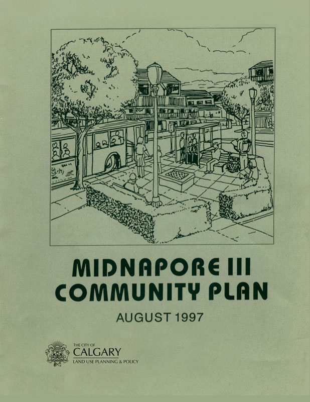
In 1997 the City of Calgary gave its approval to the Midnapore Phase III development plan, consisting of the neighbourhoods of Evergreen and Bridlewood, despite having yet to construct the Sarcee trail extension. Despite this apparent rejection of previous planning designed to prevent the overburdening of Midnapore’s roads, the City still expressed concern for the state of the transportation network serving the area. In an effort to mitigate the impacts of an increased population on the roads, a housing cap of 3000 units was implemented until such time as 37th street SW into the Midnapore area was upgraded. It is unclear why the original requirement of a full Sarcee trail/southwest ring road connection was ignored when the Phase III plan was approved, nor is it clear why an upgraded 37th street SW from Midnapore to Anderson road was considered to be an acceptable replacement condition.
Though building the southwest ring road across the Elbow river was still in the City and Province’s long-range plans, the lack of progress on the negotiations with the Tsuu T’ina or on any city-based alternative routes meant that the portion of the road south of Anderson road was the only part that could be reliably built in the short-term.
Development freezes were not a new concept for the area. Besides the phased approach to development initiated in the 1970s, the City had previously frozen development in the Midnapore area due to transportation concerns. In 1993 the City Council voted to halt all development south of Fish Creek until a new interchange and upgrades were completed on the Macleod Trail at Canyon Meadows drive, and this freeze was lifted once the improvements had been made.
The newest housing cap was to be maintained until such a time as the City could finance the widening of the existing 37th street between 146th avenue SW and Anderson road, as well as building a replacement 4-lane bridge crossing Fish Creek. In 1998 the Province committed to $680 million towards Calgary’s transportation network, and as a result of that money plus additional funding from the City and from private developers, work on the 37th street upgrades and bridge was budgeted and scheduled for a 2004 start.
Despite a commitment of funds and schedule to implement these upgrades, the timing of construction was seen by area developers as a problem for their business. Projections had shown that at the current pace of house construction, the cap of 3000 units was to be reached around 2003. This meant that there was likely to be a gap of a year or two between finishing the already approved developments, and the lifting of the cap once the new bridge was to be completed in 2005. Developers, worried about shutting down operations in this time and the inability to develop and sell their land, called for the cap to be lifted.
The Push for a Road
Despite the issue coming to City Council multiple times in 1999, the cap was retained; City Council had reiterated that the road improvements needed to be under construction before an increase in housing could be considered. At this time both the City and local developers had acknowledged that private funding could be key in bringing the construction date forward. If private developers were willing to front the cost of developing the roadway, the City would be willing to fast track the project.
In July of 2001 a group of developers consisting of Genstar Development, Tiriron Properties, Macalgary Developments and Westcreek Developments first offered $2 million to the City as an interest-free loan to get a head-start on the design phase of the work, and later offered a total of $30.4 million, again as an interest-free loan, to fund the construction of the bridge and improvements in exchange for the elimination of the housing cap. While this move was condemned by some as an example of the private sector interfering with the planning of the City, and of buying their way to the front of the line, by early 2002 the final acceptance of the loan was made by the City, and the cap was lifted.
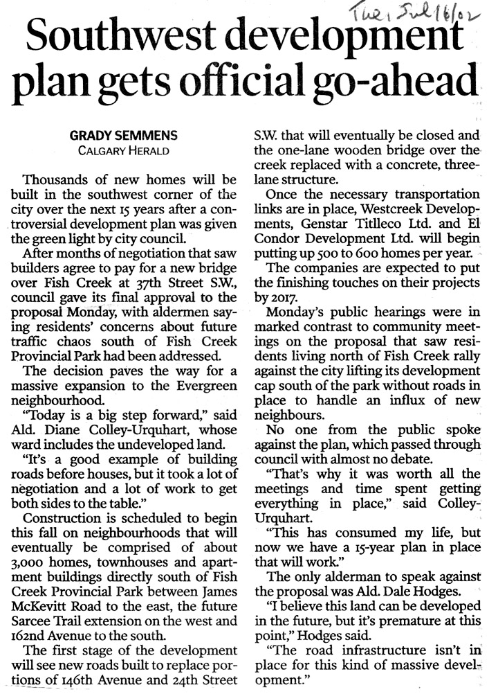
In support of the plan, Alderman Diane Colley-Urquhart stated “Today is a big step forward… It’s a good example of building roads before houses…” though Alderman Dale Hodges was not convinced that the cap was ready to be lifted. Alderman Hodges was quoted in 2002 as saying “I believe this land can be developed in the future, but it’s premature at this point… The road infrastructure isn’t in place for this kind of massive development.”
A change in scope for the bridge, including lengthening the bridge to reduce environmental impacts on Fish Creek, meant that even the lowest quote for construction came in at $2.4 million above the City’s $12 million budget for the bridge portion. A revised design finally resulted in a winning construction bid in December of 2003, and work began shortly thereafter. The result of the developer-backed loan to the City was that the timing for building the bridge was moved forward by about a year from its original schedule.
On November 28 2004, the bridge was open to the public, and after a reported 97 years of service, the old one-lane bridge was closed to the public, and was removed from Fish Creek. The old bridge, however, is not gone for good: it currently resides in a City of Calgary storage yard. What will become of this historic piece of Calgary’s transportation network remains to be seen.
Concerns with the Deal
Though hailed as a measure to help improve traffic conditions in southwest Calgary, citizens living north of Fish Creek and media commentators pointed out that this might not have been the final result. While noting that the majority of traffic originating in Midnapore would likely be traveling to destinations north of the reservoir, and since there were no improvements being planned for roads that continued towards downtown or to points north of Anderson road, there was concern that the 37th street improvements would merely shift the bottleneck away from one congested road (Macleod trail) onto others (such as 14th street SW and Elbow Drive). In addition, the resulting population increase following the lifting of the cap meant that the number of vehicles using Macleod trail and 37th street over Fish Creek, as well as every other major road in the Midnapore area, has either remained static or increased since the construction of the new bridge.
Despite the completed upgrades, calls to implement a full ring road connection for the southwest continued, and an agreement between the Province and the Tsuu T’ina in 2004 meant that steps towards the ring road were being taken.
37th street and the ring road
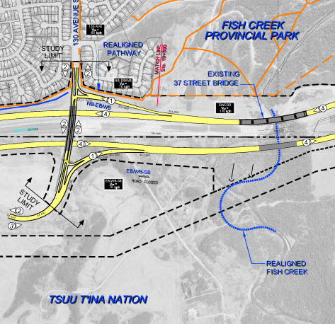
Though the 2009 plans for the Southwest Calgary Ring Road largely by-passed the 37th street corridor north of Anderson road, it fully utilised the southern potion of the corridor between Anderson road and Highway 22x. The bridge built in 2004 had originally been designed to accommodate a future ring road, and the 2009 Provincial plans showed the 37th street corridor, including the bridge, being utilised for the northbound lanes of the full ring road. The map below shows how only a single new bridge structure is required to accommodate the ‘opening day’ stage of an 8-lane southwest ring road.
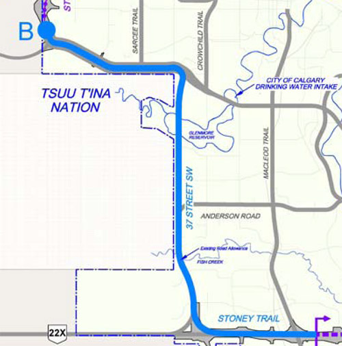
In 2011, following the 2009 rejection of the ring road proposal by the Tsuu T’ina Nation, the Province proposed their ‘Plan B‘ alternative routes, all of which would be located entirely within the City limits of Calgary. Two of the proposed routes utilised the 37th street corridor south of Anderson road, though detailed planning had not been presented to show how, or if, the existing 37th street and bridge would be incorporated into those plans (below).
With the resumption of negotiations with the Tsuu T’ina Nation, the same general route as proposed in 2009 looks like the favoured alignment at this time. The unique position of the 37th street corridor between Anderson road and Highway 22x continues to shown itself to be central in any ring road alignment the Province would be likely to consider.
———-
With thanks to Sean Somers and Sean Myers at the City of Calgary for their invaluable help.

As a long time resident of the southwest my wife and I are deeply concerned that the MacLeod Trail 22 x overpass, which has not undergone any significant upgrades in 20 years, is to remain essentially untouched. Future plans are simply to squeeze two lanes of traffic across the old bridge with a timed traffic light 1000 meters to the west, it is only going to get worse as you continue to direct more and more traffic through this bottleneck.. The Province has created an 870 million dollar Stoney Trail Highway that leads to a one lane road across MacLeod Trail. Rush hour congestion is a nightmare taking hours to cross this threshold not to mention the weekend recreational user being subjected to the same wait times. I am amazed that you have created a new overpass north of high river which is seldom used and do nothing about one of the major arterial collectors in the south. If and when the ringroad is completed the increased traffic will bring this bottleneck to a complete standstill inconveniencing thousands of drivers each and every day.
In case there is any confusion, I am not affiliated with Alberta Transportation in any way.
As for your concerns, there is every possibility that the delay in upgrading the Macleod interchange was the result of a desire to tie the work in with the Southwest ring road project, in the hopes that a deal would be approved by the Tsuu T’ina Nation. As the deal has now been accepted, Transportation Minister Ric McIver has stated that the entire remaining ring road project, including the Macleod interchange, is to be completed in tandem with the Tsuu T’ina portion. The timeframe is seven years from the time the Southwest ring road corridor is transferred to the Province, at the latest.