
This article was originally published on April 15 2015. It was updated on March 5 2016 to reflect newly found information about the City’s earliest plans for bypass routes in 1952 and 1953.
The City of Calgary and the Province of Alberta variously point to planning and studies from 1959 or the 1970s as the origin of the Southwest Ring Road.1 While these studies mark important milestones in the history of this road, particularly around planning for the current iteration, the truth is that the concept is a much older one than that.

(Township plan of Bowness, Mongomery, and what would eventually become west Calgary, 1953)
Early efforts had been undertaken to plan for roads encircling Calgary’s downtown area, notably the town plan by Thomas Mawson in 1914, though these were not acted upon at the time. It wasn’t until a post-world war two explosion in population growth and vehicle ownership in Calgary had occurred that the issue of bypass roads would again be brought to the fore.
The 11-year period between 1952 and 1963 constitute the practical origin of Calgary’s bypass road system, and would see incredible effort and progress on this issue: from outright rejection, to intensive planning, and finally to construction of Calgary’s first southwest bypass route.
The Earliest Southwest Ring Road Plans
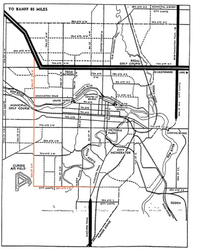
In order to address the rapid growth experienced in the post-war years, the City of Calgary began the process of creating a General Plan for the city in the late 1940s. By 1951, an interim report on the General Plan was produced, which included descriptions of primary roads planned for Calgary. A major route following 50th avenue SW across the Elbow river along the City’s southern edge and 14th street SW heading north across the Bow river2 was noted, and was intended to connect the Macleod and Banff trails and act as a bypass around the City’s core.
This interim report was followed by a preliminary major roads plan that was presented to City Council in the winter of 1952. The plan contained many of the same routes as the earlier General Plan interim report, though the southwest bypass was now envisioned along 24th street SW/Crowchild Trail, rather that 14th street SW, as the north-south portion of the route.3
(A depiction of Calgary’s Major Roads Plan as presented to City Council. Source: Traffic Problem Solution Seen. Nigel Dunn. Calgary Herald. December 19, 1952. Highlight added.)
Although these initial planning efforts focused on routes contained within the City’s limits, plans were simultaneously being prepared on a wider scale; the City’s major road plan was not intended as a final document, but was intended to be continually updated and expanded as conditions demanded.
The City’s planning department had earlier drafted a different map in 1952 that for the first time described the series of planned bypass roads as a ‘Ring Road System’, and indicates, though does not fully depict, a southwest bypass located on 37th street SW.4 This was an internal working document that was not intended for the public, and shows how the City had begun to look outside of it’s city limits at more regional roads.
In late 1953 a further revision was completed, which for the first time fully detailed a Southwest Ring Road route around the west edge of the Glenmore reservoir.5 Comprising of 90th avenue SW on the south and 53rd street SW/Sarcee Trail on the west, this version of the Southwest Ring Road shares little in common with the modern route, though the use of the Sarcee Trail right-of-way and a crossing through the Weaselhead would remain part of the Southwest Ring Road plans for decades to follow.
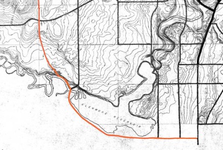
(Source: Untitled Map. December 1953. City of Calgary Corporate Records, Archives. Board of Commissioners S. IV box 189 F. 39.)
By the early 1950s the City had a defined, though extremely fluid, ring road plan. Work on the plan by the City of Calgary would continue for a number of years yet, though putting the scheme into action could not be done by the City alone; implementation would require a partner in the form of the Provincial government.
Early Provincial Proposal
At the same time as the City was beginning to envision bypass roads around the City, at least one Provincial politician was beginning to take notice of a perceived need for similar roads. Convincing the Province itself, however, would be another matter entirely; early bypass roads pitched to the Province that would later form part of Calgary’s ring road plans would not be an easy sell.
In early 1953, Calgary M.L.A. Fred Colborne wrote a memorandum on the benefits of building a bypass road between the Old Banff Coach Road (now Bow Trail) and the Shouldice bridge in Bowness. This memorandum was sent to the Minister of Highways Gordon Taylor in an effort to advocate for such a road.
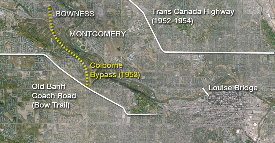 (Source: Google Maps, Memorandum ‘RE: Road from Old Banff Coach Road.’ Frederick C. Colborne M.L.A. March 1953, and ‘Plan of Township No. 24 Range 2 West of the Fifth Meridian’ Map, marked by H.E. Henderson, Supervising Engineer, Province of Alberta, March 4 1953.)
In pressing for this short bypass, Colborne noted that such a road would allow workers living in Bowness and Montgomery to be able to access the industrial areas in Calgary’s southeast without having to travel through the city’s downtown. This would help reduce congestion on the Louise bridge, the most westerly of Calgary’s river crossings at the time. The road, it was argued, would also assist in opening up new areas in southwest Calgary for development.6
The proposed location, and the proposal itself, was deemed to be unsatisfactory after a review by local engineers, and the Province rejected the idea of constructing such a road. Minister Taylor noted that in addition to the technical and financial challenges in building the road along an unstable hillside, the bypass would not connect to any provincial highways, making it a local matter. Taylor went on to say that the amount of traffic did not warrant such a road, and that the 14th Street SW bridge, set to open the next year, would address existing congestion concerns.7
Though this alignment would later form a key link in a larger Provincial bypass (and part of the proposed route of the Southwest Ring Road for many years), the Minister had spoken and the message was clear: a bypass route on Calgary’s west side was not part of the Province’s plans at that time.
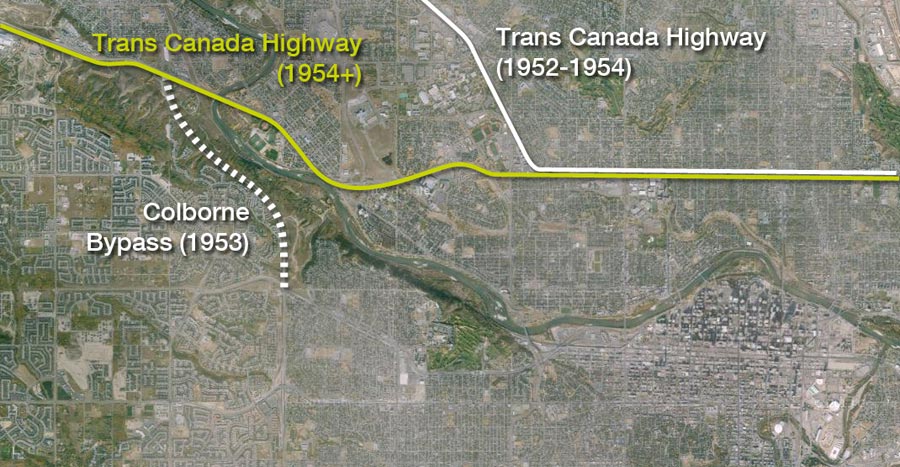
Enter the Trans Canada Highway
At the time of the rejection of Colbourne’s bypass request, Minister Taylor noted that the road would not connect with any major highway, and was thus a matter for the local municipal district to undertake if required. Though the Trans Canada Highway currently runs through Bowness, in the early 1950s the highway was instead planned to exit the city along Banff Trail (now Crowchild Trail NW). In July of 1954, however, the Province announced that a new westward path for the highway had been selected, and the proposed route would now head through Bowness near the Shouldice bridge, exactly where Colborne’s bypass would have been located.8
(Source: Google Maps, Colborne Memorandum, and ‘Traffic Problem Solution Seen’ December 19 1952. Calgary Herald.)
With the new primary westward entrance to the city now planned via Bowness, the idea of a bypass road in this location would take on new importance. The establishment of the new Trans Canada Highway alignment prompted the City to look at rural bypass roads on Calgary’s west side 9, while the Province soon revisited their previous rejection of a bypass road serving this area.
In an address to the Calgary Chamber of Commerce on November 18 1955, Minister Taylor detailed an ambitious highway construction plan for the Calgary region. Included in this address was talk of a new bypass road for the south and west side of the city, which would connect Macleod Trail, the city’s primary southern highway, to the Trans Canada Highway in the west. Coming only two years after the Province’s rejection of a bypass road on the city’s west side, this announcement not only expanded upon Colborne’s initial idea, but was also the first public announcement for a bypass road that would cross the Elbow river west of the Glenmore Reservoir,10 the City’s larger bypass plans having yet to be made public at that point. This announcement marks the entry of the Province into the long process of planning for what we now know as the Southwest Ring Road. This was particularly important, as the City by itself was not in a position to build major bypass routes on its own, and would need the Province as a partner if progress was to be made.
Provincial Southwest Ring Road Prototypes
Two routes for a southwest bypass road were reported as being under consideration at the time of the Chamber of Commerce address in 1955; a route that lay entirely within the city limits which followed 50th Avenue SW and 24th Street SW (now Crowchild Trail SW, shown in orange below) as planned by the City in 1952, and a new route that passed almost entirely though rural areas around Calgary, around the west side of the Glenmore reservoir and north on Sarcee Trail (shown in yellow). It is this second route, located at that time entirely outside of the City of Calgary and requiring no land from the Tsuut’ina Nation, that would become the first publicly proposed Southwest Ring Road.

(Source:’Further Highway Projects Sought’ November 21 1955. Calgary Herald.)
Differing Priorities
The choice presented between the Province’s two proposed routes would highlight the differences in the priorities of the Province and the City, and would reveal how each party viewed the role of bypass roads. The Province’s mandate was to construct roads to connect main highways together, and would facilitate an efficient transfer between these facilities without requiring drivers to enter the congested downtown area. The City of Calgary, by contrast, wanted new arterial routes to not only provide a bypass function between highways, but to also provide efficient access to the residential areas in the City’s northwest and southwest quadrants with industrial developments in the southeast.
Though complimentary, the contrast between these priorities can be seen in the favoured locations for the new southwest bypass road of each party: the Province would eventually prefer the more rural route that avoided most of the developed areas of Calgary, while the City would press for a more central route that would provide better access to developing land within the city limits.
“The Provincial Government have indicated that they are prepared to build by-pass roads at their expense, and some planning has been done in this connection… We (the City of Calgary) believe that the by-pass roads which are proposed by the Province will be very beneficial but will not call for the same use for the next five or ten years as an internal system of roads.”
–John Ivor Strong, Calgary Commissioner of Works and Utilities. February 28 1956 11
These conflicting interests would soon be addressed with an agreement to work together on a joint ring road plan. Despite their differing priorities, both parties recognized the value of the other’s proposal, and a cooperative planning effort led by the City resulted in a master plan containing concentric rings of both types of roads: central arterial connections and rural bypass roads. A milestone draft of the City’s ring road plan was completed in 1956, and included a slightly modified ‘outer’ southwest ring road leg, and an ‘intermediate’ route that now utilized Glenmore Trail along its southern edge.
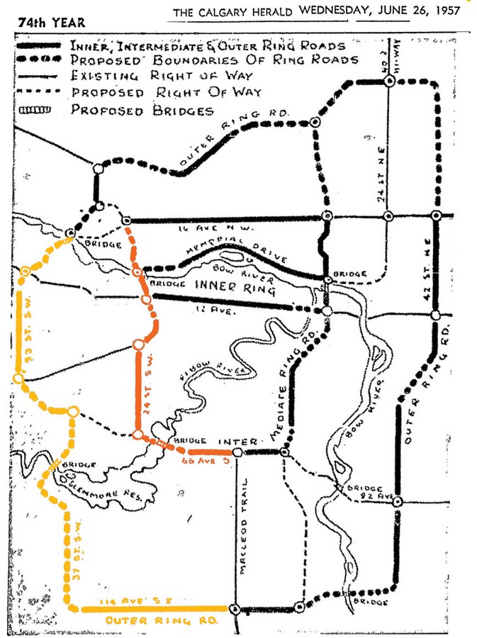 (Source: ‘Ring Roads to Provide Seven New Bridges’. Calgary Herald. June 26 1957. Highlight added)
Reluctant Planning
Following a number of years of refinement to the integrated ring road plan, including several revisions in the location of the Elbow river crossing of the ring road in the Weaselhead area, the City of Calgary undertook its first transportation study, called the Calgary Metropolitan Area Transportation Study. This work, completed in 1959, recommended that the City trim some of the more ambitious elements of their earlier road plans in favour of a more cost effective and achievable scheme. It was concluded that there was insignificant demand for rural ring roads, including the southwest leg of the outer ring road, and that construction of these routes could not be justified.
Though some bypass roads were eliminated, the Southwest Ring Road (then called the West By-pass) was retained in the final plan on account of it having been ‘firmly planned’ by the Provincial Government. The authors of the report clearly preferred the City’s intermediate bypass route, and advocated for it in the 1959 study.
“As has already been mentioned, the volumes of traffic to benefit from it are far too small to justify any sort of west by-pass, and particularly an expressway. However, the route has been planned by the Department of Highways and is therefore included in the proposed system.
However, a great deal more benefit would derive, and the purpose of the West By-pass would still be achieved, if the Province could be led to contribute the same funds toward the construction of the Bowness Expressway, the west and south legs of the Outer Ring (Crowchild Trail and Glenmore Trail), and the Macleod Trail Expressway.”
-Calgary Metropolitan Area Transportation Study, 1959
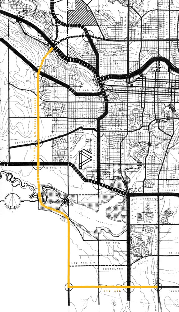 (Source: Calgary Metropolitan Area Transportation Plan. City of Calgary. 1959. Highlight added.)
Compromise and Construction
Prior to the 1959 study, the Province had insisted that the Southwest Ring Road be constructed before any consideration would be given to financing the City’s route, and wanted construction to take place before 1965. Though initially receptive to sharing costs on the Provincial route, the City’s stance would begin to shift. After the release of the 1959 transportation study, City Commissioner E. C. Thomas notified the Province that he “could not recommend that the City make any commitment at this time either towards land acquisition or sharing of constructions costs” of the Southwest Ring Road. Commissioner Thomas believed that City resources were better directed towards constructing other routes of higher priority.12
Given the low immediate demand for an outer ring road, the City’s un-cooperative position and the ability of more central routes to also provide bypass movements, the Province soon reassessed its position on the outer bypass.
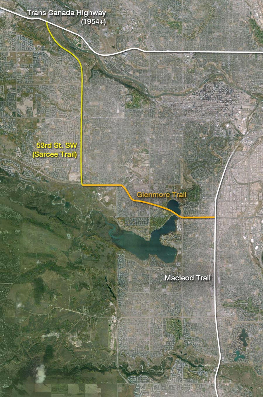 (Source: Google Maps)
In the closing days of the 1950s, the Province agreed to a compromise on a southwest bypass route, and stated that they would now be prepared to finance a hybrid route that utilized portions of both the City and the Provincial routes. Rather than a road that headed west on Anderson road to cross the Elbow river west of the reservoir, the Province agreed to instead contribute financing towards the City’s southern bypass leg (now Glenmore Trail), while retaining their original west bypass leg (now Sarcee Trail).13
Calgary’s First Southwest Ring Road
In 1963 the Glenmore Trail causeway over the Glenmore Reservoir was opened to traffic, and the first portion of Sarcee Trail, which connected the Old Banff Coach Road to Bowness and mirrored the Colborne bypass that had been rejected 10 years earlier, was constructed by the Province.
The Calgary Herald proclaimed in 1963 “Southwest Ring Road To Be Ready This Fall”, and by the mid-1960s the entire connection between Macleod trail and the Trans Canada Highway had been finished. Calgary’s first Southwest Ring Road, about a decade in the planning, was a reality.
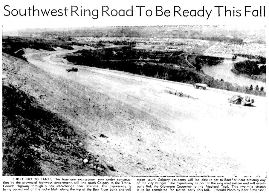
(Image: ‘Southwest Ring Road To Be Ready This Fall’ Calgary Herald, July 25, 1963.)
With a completed and functional bypass in service, the need for a rural ring road was diminished, and efforts to build the route we know today as the Southwest Ring Road would lay largely dormant for years. And although sidelined, the Southwest Ring Road route would not be forgotten; a bypass road that crosses the Elbow river west of the Glenmore Reservoir would continue to be included on all major road plans created by the City and the Province to this day.
—–
Sources
1) ‘SWCRR Functional Planning – Backgrounder’. October 2005.(http://www.transportation.alberta.ca/content/doctype490/production/swcrr_newsletter.pdf) Alberta Transportation ‘Calgary Ring Road’ website, Government of Alberta (http://www.transportation.alberta.ca/804.htm retrieved April 19 2015)
2) ‘Progress Report on the Comprehensive Plan’. City of Calgary Corporate Records, Archives. Town Planning Commission, RG1507, box 18 F. 121.
3) ‘Traffic Problem Solution Seen’ December 19 1952. Calgary Herald.
4) ‘Major Elements of Present and Projected Thoroughfares and Ring Road System Excl. South of Glenmore Dam’. Revised 1952. City of Calgary Corporate Records, Archives. Board of Commissioners S. IV box 189 F. 39.
Although the map noted above appears be the first record of a planned Southwest Ring Road route, it does not show the route to the south of the Glenmore reservoir. Specifics of the route along 37th street SW disappear south of 66th avenue SW, in what is modern-day Lakeview, so it is unknown where the southern connection to the Macleod Trail would have been located.
5) Untitled Map. December 1953. City of Calgary Corporate Records, Archives. Board of Commissioners S. IV box 189 F. 39.
6) Memorandum ‘RE: Road from Old Banff Coach Road.’ Frederick C. Colborne M.L.A. March 1953.
7) Letter from Gordon Taylor Minister of Highways to Frederick C. Colborne M.L.A. March 9 1953
8) ‘New Banff Road Via Bowness Will Run South Of Bow River’ July 23, 1954. Calgary Herald.
9) In the early 1950s the City had initially pressed the Province to have the new Trans Canada Highway cross the Bow river east of the Shouldice bridge. The route deviated from the Province’s plans on the north side of the Bow river where Shaganappi Trail now begins, and would then head south through what is now Edworthy park, and then west along the Old Banff Coach Road. When the Province rejected this plan in favour of their Bowness route, the City continued to favourably view a bridge over the Bow at Shagannappi and Edworthy park. As early as 1954 the City explored that location as part of its own bypass road, and would be included in the City’s initial outer ring road plan in 1956. The City would continue to plan for a river crossing at that location until finally being abandoned in 1995’s Go Plan. (Sources: ‘Naming The Bridge’, George Edworthy, Calgary Herald November 16, 1954. ‘Bridge Near Montgomery May Be Part Of Ring Roads’ Calgary Herald, February 13, 1956. ‘Proposed Metropolitan Thoroughfare System’ Map, City of Calgary, August 1956. Calgary Transportation Plan, City of Calgary, 1995)
10) ‘Further Highway Projects Sought’ November 21 1955. Calgary Herald.
11) Letter from John Ivor Strong, Commissioner of Works and Utilities, City of Calgary to A.W.Morrison Deputy Minister of Municipal Affairs. February 28 1956.
12) ‘Minutes of the meeting between the honourable Gordon Taylor and staff of the Department of Highways and Commissioner Thomas, City Engineer Nicolson and Streets Construction Engineer, Donaldson’. City of Calgary. November 26 1959.
13) Letter from Gordon Taylor, Minister of Highways, to Calgary Mayor Harry Hays. December 29 1959.

i don’t know what’s more depressing
that this “world class” city is acting off a concept from the 1950s
or
this city and province never bothered putting this much effort into building nice neighborhoods and communities people choose to live in
will this freeway still slice thru a natural reserve?