
This article follows on from the previous article, From No to Maybe: The turning point for the SW Ring Road, part 1.
—–
By the close of the 1970s, the Tsuut’ina Nation and the City of Calgary seemed to be at an impasse regarding the Southwest Calgary Ring Road (or the Sarcee Trail Extension, as it was then known). Though generally indicating resistance to the idea of allowing a road through the reserve, the Nation nonetheless had been willing to continue to engage with the City in discussions, noting that any chance of success hinged on the Nation deriving certain benefits from the road. The City meanwhile had seemingly made it clear that they were not prepared to entertain certain requests of the Nation, particularly access from the ring road to potential developments on the reserve, and the extension of City utilities to those developments.
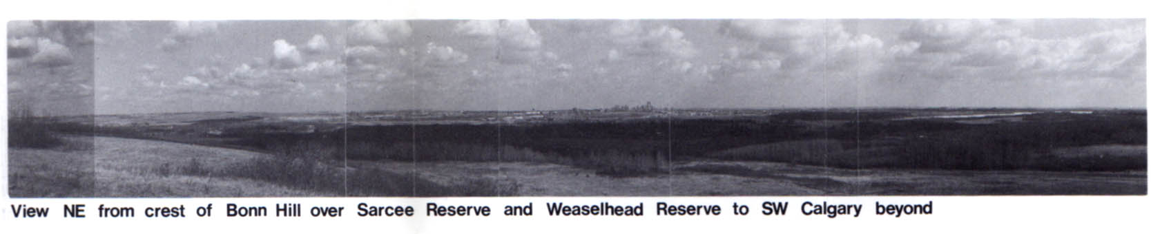
At the same time, and in a seemingly contradictory move, the City had begun to limit itself from building the road along a route through the Weaselhead area within the City limits, thus ensuring that it needed to acquire land from the Nation in order to build the road. Though conditions to this point had not yet been right for progress, both parties seemed to be heading towards a middle ground, and information and cooperation were the last hurdles to clear before the story of the ring road could move forward.
Agreeing to look at the issue
When the 1977 Sarcee Trail Extension Study concluded with two of the three potential routes crossing the Tsuut’ina reserve, the Nation indicated that they would need to undertake their own study looking at the ring road issue before any serious discussion of selling the land could be considered.
The Nation, already expressing concern over selling reserve land, had felt that the City-commissioned study failed to adequately address the needs of Tsuut’ina members, and were looking to gather information about the potential impacts and benefits such a road would create. Nation representatives had already expressed a desire to explore the development of commercial ventures on the reserve, but wanted a formal assessment of the impacts of the ring road in order to properly inform the members of the Nation, who would ultimately be called upon to vote for or against any such developments. Though this independent study was planned and terms of reference were outlined, by the end of the 1970s the study had not been undertaken.
Following the 1980 election of Mayor Ralph Klein – someone who would be noted over the years by representatives of the Tsuut’ina Nation as being well-liked and easy to deal with – moves were made to renew discussion of the Sarcee Trail Extension project. In May of 1982, Mayor Klein and Tsuut’ina Chief Clifford Big Plume conducted talks regarding the road, and a decision was made to undertake a new, joint study of the road.
The Province was soon invited to the table, and by the end of the year, a tri-partite agreement had been drafted and agreed to by all parties. The study would be paid for by all parties, with the Tsuut’ina paying for 20%, the City paying 30% and the Province covering 50% of the estimated $419,000 cost.
The 1984 Study
Unlike many transportation corridor studies, the new Sarcee Trail Extension study was meant to do more than select a location for a road and assess the potential impact such a road would have on the road network and surrounding area; the study was primarily seen as a tool to aid the Nation in deciding whether to agree to allow the road through the reserve. This was to be achieved by assessing the impacts the road would have, and by exploring the potential for development of reserve land for the economic benefit of the Nation.
Following two years of data collection, interviews, surveys and analysis, the study was completed in December of 1984 and delivered in early 1985.
Proposals and recommendation: The Route
The 1984 Sarcee Trail study studied four primary routes (shown below with alternative alignments for each) through the Tsuut’ina reserve, as well as a ‘do-nothing’ scenario. Though each route would have its own benefits and drawbacks, only a single route would be recommended by the study report.
The study concluded by selecting a primary route, Route 3, for the Sarcee Trail Extension based in part on the preference of the Nation, as well as other transportation and geographic factors that made it the most suitable alignment. This selection, shown below, largely mirrored Route K, one of the three previously identified routes from the 1977 route location study.
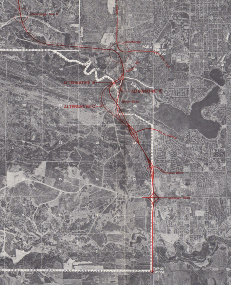
The alignment originated at the Sarcee Trail and Glenmore Trail interchange, where it headed south through the Harvey Barracks military base. It would cross the Elbow river west of the Weaselhead, and then veer southeasterly in a direction towards Southland Drive and 37th street SW. The road would then head due south along 37th street SW. Interchanges would be provided at Glenmore Trail, 90th avenue SW, Southland Drive and Anderson Road, and would include the extensions of both 90th avenue SW and Southland Drive. Though the scale of the project would change, this general route would later form the basis of both the 2009 and 2013 ring road deals.
A total of 475 acres of reserve land would be required for this route; a number which does not include the corridor through the Harvey Barracks.
Proposals and recommendation: Development
As one of the study’s primary objectives was to look at the potential impacts and benefits that the proposed infrastructure would have on the Tsuut’ina, the report contained a key section which looked at potential developments that the Nation could undertake on reserve lands adjacent to the road.
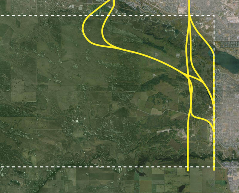
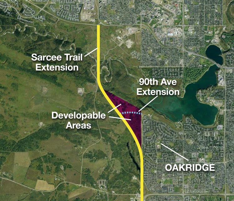
The developable area of the reserve identified in the report centred around a parcel of land just west of Oakridge. This parcel, measuring approximately 300 acres and bisected by an extended 90th avenue SW, would be isolated from the rest of the reserve by the Sarcee Trail extension and was identified by Nation members as a primary area for development (see map below).
At the time of the study, the Harvey Barracks lands west of Lakeview and north of the Elbow river was still owned by the Department of National defence. Although legal action by the Nation had been undertaken to recover the property, and the potential for commercial development of the Harvey Barracks lands had been noted, it was not considered as a potential development site in the 1984 study.
The study detailed six potential development scenarios that the consultants felt the market could potentially handle and that the land was suitable for. These scenarios included a mix of residential, recreational and commercial components. While not meant to be a definitive or exhaustive list of options, the scenarios were meant to illustrate some of the development possibilities that could be open to the Nation.
Development Scenario 1: Shopping and Travel: This scenario was centred around local and longer-range travellers using the Sarcee Trail Extension. The portion of land directly west of Oakridge and south of 90th avenue was to house a large regional shopping centre, which would draw from most of southwest Calgary. The portion of land north of 90th avenue would either be turned into a luxury motor-home park with amenities, or a specialty hotel catering to the ‘equestrian traveler’.
The motor-home park, situated overlooking the reservoir with up to 300 stalls, could potentially support an adjacent 9-hole golf course, horse boarding facilities, family restaurant, lounge, swimming pool, plus gas and mechanic facilities all aimed at the motor-home customers, with the potential for a motel at the site.
Alternatively, in recognition of the Glenmore Equestrian Centre that was under consideration for development in South Glenmore Park, a ranch-style hotel could be built overlooking the reservoir, with a riding centre, horse barns, paddock and training facilities. The hotel could also have their own stock of horses in order to offer visitors rides through the Weaselhead and up the Elbow river valley.
Development Scenario 2: Shopping, Residential and Sports: Under this concept, about 90 acres of land adjacent to Oakridge and south of 90th avenue would be used for a smaller ‘sector’ shopping centre. It was noted that the centre could be anchored by a retailer like Canadian Tire, Woolco or K-Mart and could include recreational amenities like a bowling alley or a movie theater. A strip of commercial developments could be developed along an access road that would parallel the Sarcee Trail Extension, and would house businesses such as car-dealerships and mechanics.
A residential community comprised of about 35 1-acre lots arranged around a 9-hole golf course could be considered for the area north of 90th. An alternative option would be to build a sports facility and athletic club, with running track, track and field event area, ‘executive’ golfing area, swimming pool, snack bar and interpretive markings for historical locations in the area.
Development Scenario 3: Residential Acreages or Larger Commercial Lots: Eschewing the idea of anchoring the area around a major retail facility, scenario 3 would instead see the land divided into 2 acre lots. These lots could be used either as ‘country residential’ acreages, or as commercial lots. One possibility would be to have a mixture of the two, with the residential located north of 90th avenue, and a commercial area located to the south.
Development Scenario 4: Lake Community with Commercial Land: The fourth option presented would see the area west of Oakridge developed largely as a residential neighbourhood. The estate area of Oakridge would essentially be continued west, possibly centred around an artificial lake like Lake Bonavista or Lake Midnapore, while other single-family and multi-family residential lots would make up much of the rest of the land. As in scenario 2, a strip of commercial development could front an access road alongside the Sarcee Trail Extension..
Development Scenario 5: Traditional Residential Subdivision: This option would see the land be used entirely as a single-family residential neighbourhood. This community would act essentially as a westward continuation of Oakridge, though accessed only via 90th avenue. As with any neighbourhood, smaller commercial amenities could be integrated, including convenience stores, gas stations, dry cleaning etc.
Development Scenario 6: Super Shopping Centre and ‘Disneyland-like Complex’: Scenario six is characterized in the report as “the most imaginative and daring of the six proposed (scenarios)”. and deviates significantly from the previous proposals. The entire 300 acre site is proposed to house a ‘super regional shopping centre and entertainment complex’, akin to West Edmonton Mall and anchored by four department stores.The centre would draw customers from the entire of southern Alberta, and would be marketed as a family entertainment complex that would include not only shopping, but also a range of indoor and outdoor activities. This “small Disneyland-like complex” was envisioned with a monorail system with stations that would link the different shopping areas within the mall with outdoor attractions and parking.
In the end, the report did not recommend any one option or land use to the Nation. Instead, the information was intended to illustrate the area’s potential, and to assist members of the Tsuut’ina in deciding if there was value in allowing the development of the road. The decision would ultimately be decided only by the members of the Nation directly.
An Agreement is Reached
With the City now willing to allow access from the road to reserve developments, the benefits to the Nation were becoming clear and increasingly welcomed by the Nation. A key objective of the study was fulfilled in July of 1984, when members of the Tsuut’ina Nation voted in favour of proceeding with negotiations to locate the Sarcee trail extension through the reserve. The question “Should the Band Council negotiate an Agreement to allow the extension of the Sarcee Trail near the eastern boundary of the Reserve?” was assented to by the majority of the electorate, and officially opened the doors to formal ring road negotiations.
Though the study did appraise the cash value of the 475 acres needed for the road right-of-way ($4,653,100) the report was clear that this did not include other payments that would compensate for impacts to the Nation. A ‘shopping list’ of potential areas of negotiation and compensation was developed by the Tsuut’ina Nation and included in part: agreement by the Nation over the route and nature of the roadway, provision of access to reserve lands from the road, a land exchange, cash compensation, the relocation of reserve residents and infrastructure impacted by the road, agreed upon construction timing, the potential employment of Nation members, other business opportunities stemming from the construction of the road, and more.
These requirements would continue to play a role in all future negotiations, including the final agreement eventually approved in 2013. It is particularly interesting to note that several of the reasons noted by the Nation as contributing to the failure of the 2009 deal, including the non-guarantee of the land swap, were included in this original list drawn up 25 years previously. The 2013 deal was drafted to include not only the land guarantee, but also many of these other originally identified requirements.
Unfinished Business
The City formally adopted ‘Route 3’ in 1985 (shown below) and although negotiations were publicly announced at that time, progress was slow.

A deal for the Sarcee Trail Extension through the reserve may have been firmly on the agenda for all parties, but many factors would keep the project from becoming a reality for decades to come. An economic downturn already underway in the early 1980s would impact many road projects in the province, including the ring road, and the difficult decision for the Tsuut’ina regarding the sale of reserve land would continue to play a role in negotiations for decades to come.
Despite the delay, the groundwork had been laid toward working out a deal for the road. While all parties would have to wait another generation for the on-again off-again negotiations to bear fruit, these talks would continue to be grounded in the work done in the early 1980s.

What is the status of the SE Ring Road. There are still dirt piles everywhere, many areas still require grading, there is at least 60% or more that has no topsoil, every bridge abutment is not finished, there is no vegetation planted and soil is actively eroding, the borrow pits are all left in a mess, etc.
There is not a piece of equipment anywhere and there is a substantial amount of work left… and yet we celebrated the completion of this project. It is no completed, it is an eyesore.
FINISH THE JOB YOU STARTED!