
The release of a ‘virtual tour’ video of the Southwest Calgary Ring Road this past week has given the public a chance to view the proposed plans for this road in a way that maps have not been able to. The detail and context provided by the video has raised concerns over the impacts the road will have on southwest Calgary, including the Elbow River, Fish Creek and the Weaselhead. The nature, size and proximity of the cut-and-fill river crossing, combined with a realignment of the rivers, appear to be at the heart of these concerns.
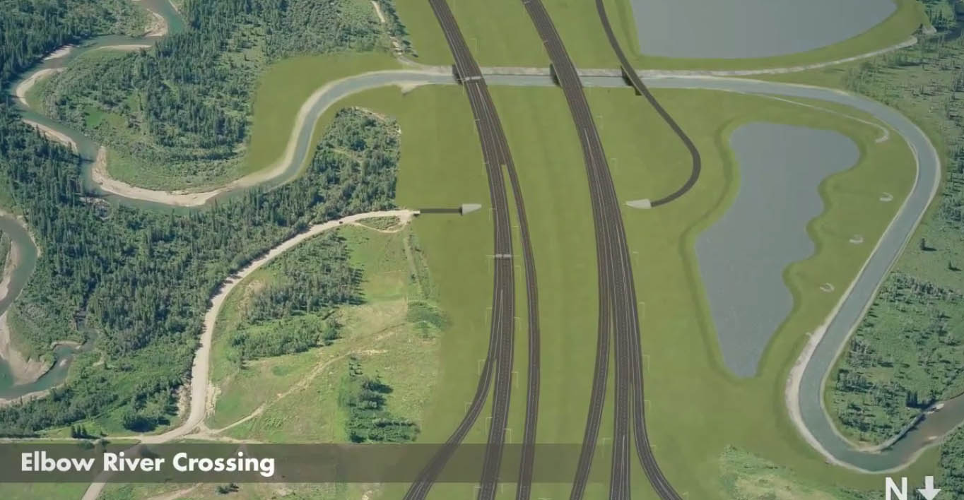
(Source: Alberta Transportation)
The crossing of the Elbow river is arguably the most important link in the Southwest Calgary Ring Road project. This new crossing of the Elbow river in southwest Calgary, the first since the Glenmore causeway opened in 1963, is projected as being the single most utilized portion of the new road. Establishing this crossing has seen numerous proposals over the years; from a low-level bridge in the 1950s to a dam in the 1980s (creating a new reservoir upstream from the Weaselhead) to a consideration of a high-level bridge, and even talk of a tunnel, in the 2000s. A new crossing of the Elbow river is an idea that has undergone many revisions and alternatives in the decades since it was first proposed.
The first part of this story looks at the early proposals and the history of the crossing of the Elbow River, from the first proposal in 1956 to the project’s (temporary) cancellation in 1986. Part two, which looks at the modern river crossing plans and alternatives from 2000 to 2014, will follow.
Early plans: models and maps
In 1955 the Province of Alberta made public its desire to establish a bypass highway in Calgary’s southwest, and by the following year, the City had drafted initial plans for this road. Around the same time the City was also developing plans for the Glenmore Reservoir parks, and these two proposals would converge in the form of the first publicly released concept for the Southwest Ring Road, then known as the West Bypass, and its crossing of the Elbow river.
The ambitious plan for the proposed Glenmore Parks, containing an aquarium, a solarium, botanical gardens, an ‘Indian Village’ and more, was estimated to cost $3 million and would take upwards of 25 years to implement. When the City’s planning department was seeking approval from both the public and the City Council for the proposed park system surrounding the Glenmore Reservoir, they created a model of their proposed ideas. Along the western portion of the model lay the West Bypass, and its crossing of the Elbow river was presented to the public for the first time.
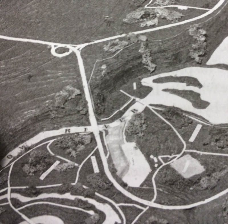
(Glenbow Archives NA-5600-8138a. Click for an enlargement of the Elbow River crossing)
The crossing, depicted as a 4-lane low-level bridge of about 180m in length with some amount of cut-and-fill on the north bank of the valley, was only conceptual at this stage. Detailed work on the entire development had yet to be carried out at the time of the model’s creation, and no engineering had gone into the designs at this point. (The road is shown along the bottom of the photograph above).
For the next two decades this road crossing of the Elbow river would appear on all City planning documents, though given its status as a long-term plan, the route would consist of little more than a line on a map for much of this time.
Routes proposed but details lacking
In 1974 the Provincial Government commissioned a study of the ring road system which included a 4-lane southwest leg of the road, by this time known as the Sarcee Trail. This document was a preliminary evaluation of the road, and as such, it contained no detailed planning. What it did contain, however, was an assessment of impacts that would have to be addressed before any road plan could be implemented. The importance of the Elbow river valley, in recreational and environmental terms, was noted, and for this area the report stated that “The Sarcee Trail crossing of the Elbow River would require a very sensitive design treatment to minimize the impact on the existing and proposed park development.”
By 1977 the planning for the road had progressed to a point where some of the specific implementation options were beginning to be taken into account. Both a high-level bridge and a low-level causeway were considered, and their relative benefits assessed with regards to issues of noise and visual impacts. In addition, due to the inclusion of routes that crossed the wetland portion of the Weaselhead, the following was noted:
“With regard to the required bridge length, the basic criterion must be to pass the design flood. However, of equal importance is the need to ensure perpetuation of the deltaic environment by providing a degree of flexibility for the river to adjust gradually to the restricted opening. In addition, it is necessary to consider flow and wave action protection, with due consideration for the aesthetic qualities of the area.”
A low-level causeway with a bridge of at least 250m long was recommended for one of the three route options (route ‘A’ shown below on the right), though this route would not ultimately be selected for the ring road. The remaining two routes, ones that crossed the Tsuut’ina reserve, were not assessed in detail at this time, and so an overall recommended route was not selected.

(Source: Sarcee Trail South Route Location Study 1977, City of Calgary)
After a brief hiatus, a further study of options was undertaken in 1984 which focused on route location, though not on the specific design of the road. The successful result of this study was the selection of a route for the 6-lane road that would look familiar today. With a route selected as a result of this study, detailed planning would shortly begin.
Dam, reservoir and causeway alternatives
In 1985 the City and the Province engaged engineering firm Reid Crowther to begin the functional planning of the road. With a general route location selected as a result of the 1984 study (below), the new functional planning study focused on the specific alignment, land requirements and the general design of the road, including interchanges and river crossings.

(Source: Personal Communication, City of Calgary)
At the same time as the Sarcee Trail plan was being undertaken, another study had been commissioned on behalf of the Alberta Government, which looked at the impacts of flooding on the Elbow river. Among the recommendations of the 1986 Elbow River Floodplain Management Study was the creation of a dam and a new reservoir on the Elbow river just upstream of the existing Glenmore reservoir, only metres from the Weaselhead. This proposed reservoir would necessarily flood a portion of the Tsuut’ina reserve.
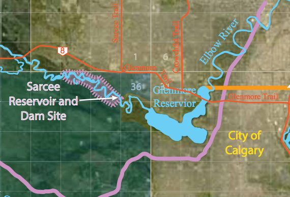
(Source: Elbow River Historical Detention and Diversion Sites 2014, WaterSMART Solutions Inc.)
An earthen-dam was proposed to lie in approximately the same location as the selected route of the Sarcee Trail Extension, and this concurrence provided an opportunity. The Province suggested to the road planning team that an alternative crossing for Sarcee Trail incorporating a dam be drafted. The 1987 road study notes that ‘Alberta Environment recognized that “combining the highway crossing with a dam presents some economic benefits in terms of construction; however the area of inundation, ease of land acquisition, other uses of the water body created and many other factors must all be evaluated”.’
Both a traditional road and an earthen-dam alternative were drafted. The dam design preferred by the City of Calgary would have seen the road located on a lower part of the berm, on the downstream side of the dam, with powerlines along the top and pipelines running under the newly created reservoir. The Floodplain Management Study notes that dams with heights between 22m to 26m would result in a new reservoir that could contain between 42 and 65 million cubic metres of water.

(Source: Sarcee Trail Extension Transportation Utility Corridor Study 1987, City of Calgary)
This proposed dam, along with the more traditional low-level causeway, formed part of the recommended alternatives at the conclusion of the 1987 study. The report was received by the City, and although endorsed by the engineering firms responsible for their respective reports, the Tsuut’ina were apparently not in agreement with, or even notified of, the recommendations.
In late 1988 the Tsuut’ina and the City held a meeting regarding the Sarcee Trail project, and while a dam was apparently not on the agenda, that particular proposal was raised by the Tsuut’ina as a point of concern. The proposed dam and reservoir would encroach onto the Tsuut’ina reservoir, but evidence that the Nation were consulted during the preparations of these plans is lacking. Chief Clifford Big Plume stated that he had only just found out about the proposed dam and reservoir in November of 1988, and that the Nation would not consider the idea. A reportedly angered Big Plume is quoted as saying that some City and Provincial negotiators “still think they live in the days of horse-swapping and want to lump several deals together” and that the Nation “…gave away land for the Glenmore (reservoir) in the ’30s… That was enough.”
Indefinite hold
By the mid 1980s the City had placed a low priority on the extension of the Sarcee Trail, having been excluded from the City’s Transportation Improvement Priority Study in 1986, and by the end of that year the project had been terminated. In addition, noted difficulties in agreeing to appropriate compensation for land in the Tsuut’ina reserve meant that further attempts to restart the project were unsuccessful for many years following. The western crossing of the Elbow river was again on the City’s back-burner.
—–
In part two, Crossing the Elbow River 1990 – 1995 I look at the consultation and planning that went into Calgary’s Transportation Plan in the 1990s, and the reassessment of new river crossings.
—–
Thank you to Glenn Davis and Cameron Matwie from the City of Calgary.

This post includes more great historical information on how the road infrastructure issues have been described in the past. However, the references to unidentified concerns being expressed by unidentified entities is a bit too vague.
“The detail and context provided by the video has raised concerns over the impacts the road will have on southwest Calgary, including the Elbow River, Fish Creek and the Weaselhead.”
“This will include a look at what the modern plans entail, and the concerns that are being raised about potential impacts the proposed river crossing will have on the Elbow river valley.”
As a geologist and fluvial geomorphologist wanna-be, I can state that the proposed crossing of the Elbow River and Fish Creek do not allow sufficient room for the dynamic meandering fluvial systems to operate as they currently do. The proposed short distances between the armored banks will result in longterm loss of channel diversity. Not allowing adequate room for the rivers to meander would result in degradation of fluvial and terrestrial habitat; and water quality for a primary drinking water source for the Calgary area.
Hi Jonathan,
The references to concerns with the current SW Ring Road plan were left intentionally broad for this article. Part one of this story focuses on the historical account of the crossing of the Elbow River, while Part two will feature a specific look at contemporary plans.
Thanks!