Calgary Ring Road Fully Open – 70 years in the Making

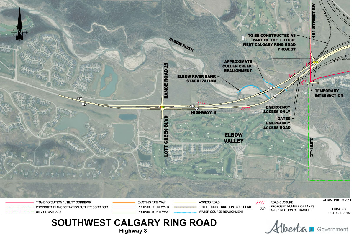
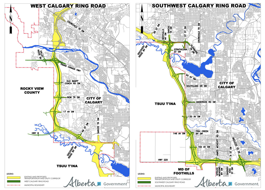
The Government of Alberta has announced that the west leg of the Calgary Ring Road, connecting Highway 8 to Highway 1, will be fully open to traffic as of December 19, 2023. This is the last of the five legs of the road to be constructed and opened, and marks the effective completion of the road, which has been 70 years in the making.

Calgary Mayor Jyoti Gondek speaks at the opening of the west leg of the Calgary Ring Road, along with (L-R) Transportation Minister Devin Dreeshen, MLA Eric Bouchard, Calgary-Lougheed, and Premier Danielle Smith

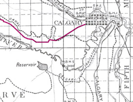
The Calgary Ring Road plan started life in the early 1950s, in response to a city experiencing rapid growth in both housing and in automobile ownership during the post-World War II era. Early road planning in the 1950s had at first been restricted to the City’s limits at that time, but by 1953, the plans were expanded to include the greater Calgary area. The map below, from December 29, 1953, or almost exactly 70 years ago, shows the earliest known regional road plan that includes a prototype ring road alignment (particularly evident on the west side of the city).

Untitled Map. December 29, 1953. City of Calgary Corporate Records, Archives. Board of Commissioners S.IV Box 189 f.39.

The ring road was not intended to be built when these plans were being developed, and was viewed as something that would be needed in a 30-year time-frame at earliest. A portion of the ring road was first approved to be built in the early 1980s, but an economic recession put those plans on hold. The first leg of the road, in Calgary’s northwest quadrant, would not see construction until 1995 (See The Ring Road System – Implementation for more information).

Over the following 28 years, the remaining legs of the road were steadily constructed. The opening of the west leg represents the culmination of plans that span half the life of the City of Calgary itself.

(For more on the earliest planning of this road, see The Ring Road System – Initial Outlines)

SW Ring Road Work Set To Begin

Update September 15 2016: A $1.42 billion contract (adjusted to 2016 dollars) has been signed between the Province of Alberta and Mountain View Partners for the construction of the Southwest Calgary Ring Road project. Click here for details.


Mountain View Partners have been selected to begin initial work on the Southwest Calgary Ring Road project under an interim agreement. While the full contract will not be entered into until September 13, this interim agreement will allow work to begin along the road corridor, including the relocation of utilities. The Alberta Government expects to see crews and equipment on the project site by mid-July.

Mountain View Partners is a consortium consisting of:

  • Project Lead:  Meridiam Infrastructure North America Fund II, as managed by Meridiam Infrastructure North America Corp.
  • Financing Lead:  Meridiam Infrastructure North America Fund II, as managed by Meridiam Infrastructure North America Corp.
  • Design-Construction Lead:  Kiewit Management Co.
  • Operation and Maintenance Lead:  Alberta Highway Services Ltd.


Click Here for maps of the full Southwest Calgary Ring Road Project.


Source: “Southwest Calgary Ring Road construction begins” July 8 2016. Government of Alberta.

2015 Southwest Calgary Ring Road Maps

The following maps were released to the public in October of 2015 by the Province of Alberta, and rather than relying on older or historical maps of the project, I wanted to ensure that the most up-to-date information was available to readers. These are likely to remain the most current views of the road until a contractor is selected in September of this year.

Please click on the maps for larger versions.

Southwest Calgary Ring Road Route

From North to South, the following maps show the full route of the Southwest Calgary Ring Road project as it currently stands:

1) While not part of the Southwest Calgary Ring Road, Highway 8 from Lott Creek Boulevard to the Calgary City Limits at 101st Street SW will be twinned as part of the project, including a new bridge over the Elbow river.

01-SW-CRR-Highway_8


2) The Southwest Ring Road begins at the Highway 8 Corridor, from Calgary City Limits at 101st Street SW, to the interchange at 69th Street SW.

02-SW-CRR-69th_Street_SW


3) Interchange of Glenmore Trail SW and Sarcee Trail SW, including Glenmore Trail upgrades between Sarcee Trail SW and the 37th Street SW interchange. Also shown are the interchanges with Westhills Way SW and Strathcona Street.

SW-CRR - Sarcee Tr SW / Glenmore Tr SW / 37 Street SW / Westhill Continue reading “2015 Southwest Calgary Ring Road Maps”

Three Groups Shortlisted to Bid on the Southwest Calgary Ring Road


Update September 15 2016: A $1.42 billion contract (adjusted to 2016 dollars) has been signed between the Province of Alberta and Mountain View Partners for the construction of the Southwest Calgary Ring Road project. Click here for details.

Update July 8 2016: The Alberta Government have entered into an interim agreement with Mountain View Partners to begin initial work on the Southwest Calgary Ring Road project. Click here for more.


The Government of Alberta has shortlisted three consortia to bid on the Southwest Calgary Ring Road project, following the completion of the Request for Qualification (RFQ) process in August. Five groups in total responded to the request, with Mountain View Partners, Southwest Connect and Valley Link Partners having been selected.1

CRR_SW_2014

The Province is proceeding with the Southwest Calgary Ring Road as a 30-year Design-Build-Finance-Operate P3 (Public/Private Partnership) project, and is anticipating to contribute partial funding of between 50%-70% of the capital cost of the project.2 The selected groups will now submit proposals for the project in a Request for Proposal (RFP) process that should last about nine months.3

Representatives of Alberta Transportation have indicated that the contract for the Southwest Calgary Ring Road project is to be awarded in the first week of September 2016.

The RFP process includes:

  • “Outlining preliminary details of the design, including the roadway, bridges and other elements of the project”
  • “Outlining their management plan and schedule for the construction of the project”
  • “Detailing how they plan to provide partial financing for the construction of the project; and”
  • “Outlining their management plan to operate, maintain and rehabilitate this segment of the Calgary Ring Road over the 30-year operations period.3

Continue reading “Three Groups Shortlisted to Bid on the Southwest Calgary Ring Road”

Federal Funding Announcement

On Thursday July 30 2015, Federal Minister for National Defence and Multiculturalism Jason Kenney, along with Alberta Minister for Transportation Brian Mason, announced Federal funding for the Southwest Calgary Ring Road project.

At the announcement, also attended by Tsuut’ina Chief Roy Whitney-Onespot, Kenney detailed a commitment of $582.9 million, which represents one quarter of the estimated $2.8 billion cost for construction of this leg of the road. The funds are being earmarked from the National Infrastructure Component of the New Building Canada Fund, which ‘provides funding for projects of national significance’1.

July_2015_update_new

(Map showing the newly revised route of the Southwest ring road; from Macleod trail in the south, to west of 101st street SW in the west.)

Continue reading “Federal Funding Announcement”

Highway 8 and the Ring Road

This month, the Government of Alberta revised the plans for the Southwest Calgary Ring Road Project by extending the western portion of the road into the Highway 8 corridor. This section of the ring road, what is currently Highway 8 from Sarcee trail to just west of the Calgary city limits and highlighted below in blue, had until recently been a part of the West Calgary Ring Road Project. This change shifts approximately 5km of roadway to the Southwest ring road, adds one additional interchange (69th street SW) and a new crossing over the Elbow River to the project, while removing the same from the West leg of the road.1

July_2015_update_new(The previous Southwest ring road route in green, with the addition of a portion of Highway 8 in blue, making up the most recent Southwest ring road alignment.2)

This section of Highway 8, between Sarcee trail and 101st street, has played an important role in the history of the ring road, not only recently, but for many years before.

South Morley Trail, Springbank Trail, Richmond Road and Highway 8

The modern Highway 8 partially follows the route of one of the oldest roads on Calgary’s west side. Richmond road, first known as South Morley Trail, was a key trail west of the city in the 19th century, and originally connected Calgary to the Stoney Nakoda First Nation Reserve via Springbank.3

1894_Richmond_Road(The Richmond road corridor highlighted in pink, 1894.3)
Continue reading “Highway 8 and the Ring Road”

SW Ring Road Land Transfer Approved

On May 1 2015 the Privy Council of Canada passed order 2015-0556, which authorizes the transfer of the proposed Southwest Ring Road corridor to the Province of Alberta. The same day, the Council passed a separate order, 2015-0557, which adds and incorporates former Alberta Crown lands into the Tsuut’ina reserve. With these two documents the land acquisition required for the Southwest Calgary Ring Road is approved.

The Province transferred $275,000,000 to the federal government in April of this year. The payment for the land will only be forwarded to the Tsuut’ina Nation, and the land title will only be assigned to the Province, once the Federal Minister of Aboriginal Affairs and Northern Development Canada signs off on the transfer.

reserve_overall_1
(Source: Canada Lands Survey Records (CLSR) 103661 January 21, 2015 and CLSR 103574-1 December 17, 2014. Image: Google Maps)

The Image above shows the new boundaries of the Tsuut’ina reserve. The original reserve (created in 1883) is shown in blue, while the newly added land (2015) is shown in magenta. The Weaselhead (1931), the Highway 22 corridor (1957) and the Southwest Ring Road corridor (2015) have been removed from the original reserve.

Moving Forward

The 2013 referendum of Tsuut’ina members, and the subsequent ratification of the agreement, meant that the Nation approved the sale and exchange of lands in order for the Province to acquire the corridor needed to build the Southwest Calgary Ring Road. Over the past 18 months, both the Province and the Nation have worked to fulfill their obligations under the agreement, in order to ensure that the land transfers would be approved by the Federal Government. Once the transfer has been enacted, which provincial representatives expect soon, the Province will have seven years in which to construct the road.

The commitment to construct the road was recently reaffirmed by former Premier Jim Prentice in the Progressive Conservative’s 2015 Provincial Budget, with construction of this leg of the ring road planned to begin as early as 2016. Though a new government is now in place, a finalized transfer of the corridor will oblige the Province to construct the road as agreed, or face the loss of the land and the money already paid.

Premier-designate Rachel Notley did not take a definitive stance on the Calgary Ring Road in the course of the 2015 election campaign, though she is quoted in relation to the ring road project as saying “In principle we are adopting the capital funding envelope and the vast majority of the commitments that the [Progressive] Conservatives have already adopted so you’d see us being in line with what’s already in the budget.” (Calgary Herald, April 29 2015, ‘Wildrose Leader Brian Jean promises to finish Calgary ring road by 2021′)

Continue reading “SW Ring Road Land Transfer Approved”

Budget 2015 and the Ring Road

Yesterday the Alberta government announced details of the proposed budget for 2015, which includes information about the two remaining portions of the Calgary Ring Road. As a cost-cutting measure, the West Calgary Ring Road is being delayed by four years, and construction is now slated to begin in 2020/2021. Expected completion of this leg, and ultimately the entire ring road, will not occur until 2024/2025, and the measure is expected to defer a reported $1.5 billion from the current budget time-frame. W&SW_Ring_Road The Southwest Calgary Ring Road, the portion that runs through the Tsuut’ina Nation reserve, remains unaffected. Work will begin on this leg of the road once the Tsuut’ina land transfer has been approved and once a contract has been tendered and awarded, with construction expected to begin next year. The agreement signed between the Nation and the Province in 2013 commits the Province to open the Southwest portion of the road within 7 years of the land transfer, and the opening is estimated to occur in 2020. The 2015 budget allocates $2.9 billion over the next 5 years towards the construction of Alberta’s ring roads. This figure includes funds needed to complete Edmonton’s Anthony Henday Drive as well as beginning work on the Southwest Calgary Ring Road (interestingly referred to as ‘Southwest Stoney Trail’ in the Province’s 5-year Capital Plan despite a promised name change as the road crosses through former Tsuut’ina reserve lands).

Storm Trunk Relocation: The first steps to the SW Ring Road

In June of 2015, the City of Calgary will begin to construct some of the first tangible work on the Southwest Calgary Ring Road Project. This work will not be on the road itself, but will be related to utilities that will run under part of the project.

The City and Province of Alberta has agreed to construct a new storm sewer line to replace the existing South Richmond Storm Trunk that currently crosses a portion of the Tsuut’ina Nation reserve known as ‘the 940‘. The new line will be located entirely within the City of Calgary city limits along 37th street SW in Lakeview when completed, while the old line will be abandoned. This abandonment and replacement is not due to the functionality or suitability of the existing infrastructure, rather it is necessary due to reasons that are political and jurisdictional in nature; reasons that go back more than 60 years.

stormtrunk_b

Continue reading “Storm Trunk Relocation: The first steps to the SW Ring Road”

Crossing the Elbow River – 1990 to 1995

This article is the second in a series looking at the history of the crossing of the Elbow river near the Weaselhead. Part 1: 1956 to 1986 can be found here, and parts 3 and 4 will follow.


In the 1970s and 1980s, planning for the Southwest Calgary Ring Road, also known as the Sarcee Trail south extension, was characterized by practical considerations such as route location, land acquisition and functional planning. The period of the 1990s by contrast would be marked by something of a step-back from applied planning, and would include a serious re-examining of priorities.

The continued dominance of the automobile and the crossing of Calgary’s rivers by a network of freeways has often been seen as inevitable. This view, however, would be challenged by a renewed expression of concern over the impacts this situation would have on parks, communities and natural areas.

A New Transportation Bylaw for Calgary

In May of 1990 the City of Calgary released a preliminary look at a proposed bylaw that sought to affirm the city’s future transportation needs. In addition to public transit, bylaw 29M90 also detailed Calgary’s existing road network and plans for future expressways and freeways throughout the city. The plan was composed largely of elements from previous planning efforts, and included a map that showed proposed roads that had long been a part of City plans, including some that dated back to the early 1950s. The bylaw also contained a number of previously proposed, but as-yet unbuilt river crossings, including the southern extension of Sarcee Trail across the Elbow river. It is these crossings that would spark Calgary’s largest public consultation efforts undertaken to that point[1].

1990_crossings

(Source: Calgary bylaw 29M90. City of Calgary, 1990)

The bylaw included the following new river crossings (also shown above):
1. Stoney Trail NW over the Bow river
2. Sarcee Trail north extension over the Bow river
3. Shaganappi Trail south extension over the Bow river
4. South Downtown Bypass over the Elbow river
5. 50th Avenue South over the Elbow river
6. Sarcee Trail south extension over the Elbow river

Public reaction to the proposed bylaw was swift and largely unfavourable, with citizen groups particularly denouncing the negative impact that new river crossings would have on parkland, river valleys, natural areas and local communities[2]. Within a month of the bylaw’s unveiling, several hundred citizens had attended a City Council meeting on the topic, and many more contacted Aldermen, signed petitions and formed action groups to oppose the plan and to call for the process to be opened up to public consultation.

Although the bylaw was approved by Council in July 1990, the response from the public spurred the City to begin a multi-year, multi-million dollar consultation and review of the road network and future transportation needs the very next year. This process was called the GoPlan.

goplan

Continue reading “Crossing the Elbow River – 1990 to 1995”