Tsuut’ina Trail Officially Named

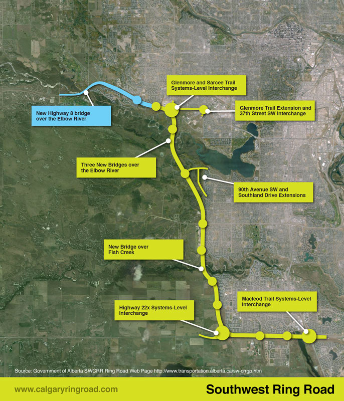
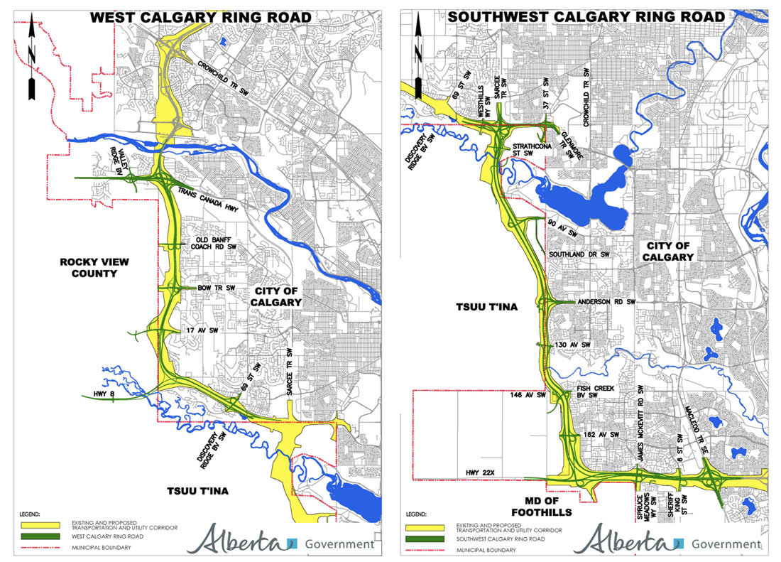
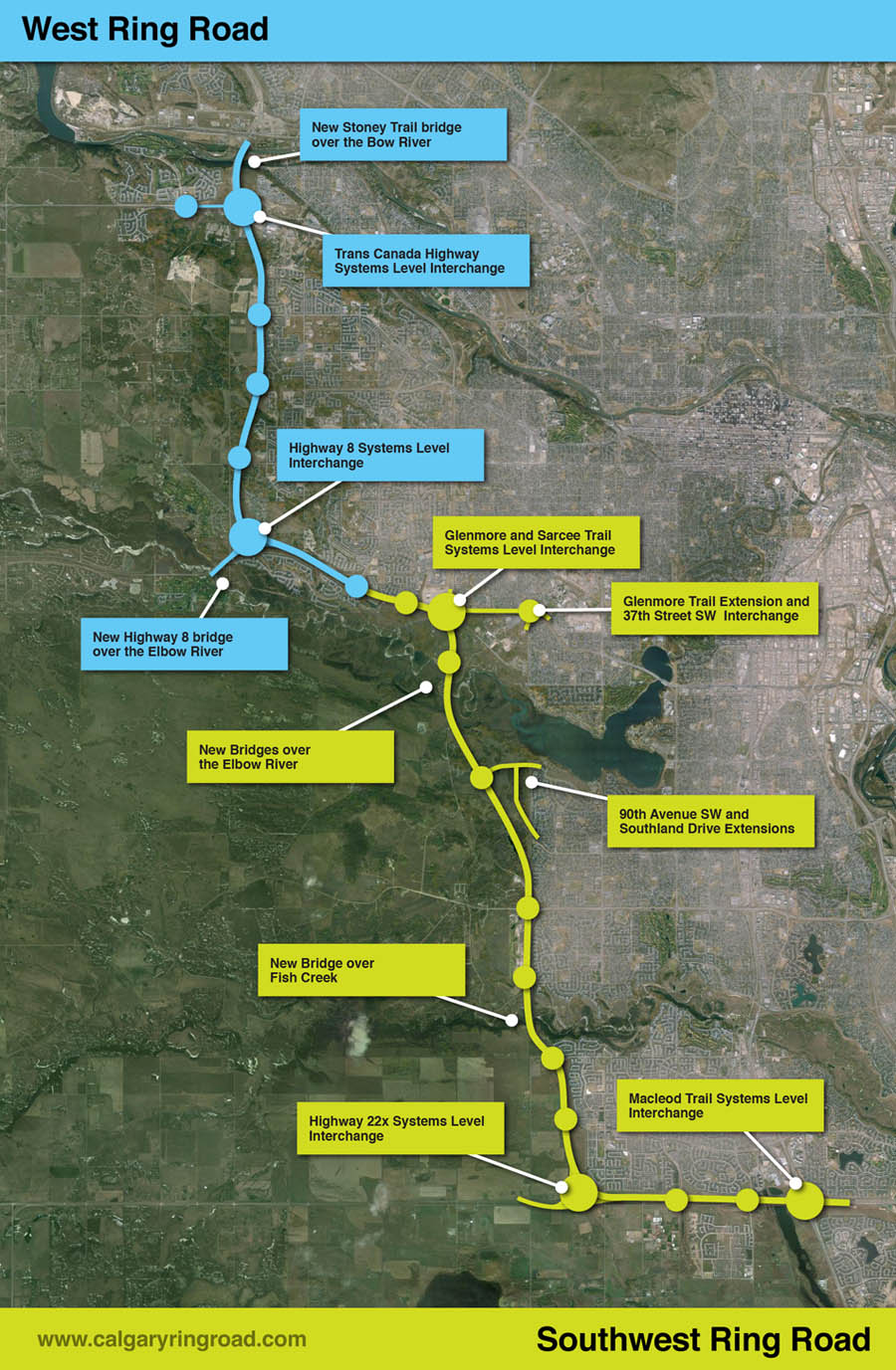
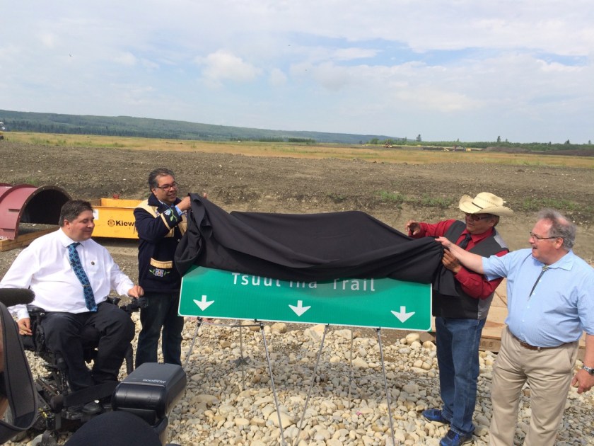
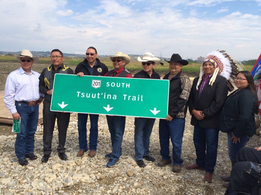
Today, a new name was unveiled for the Southwest portion of Calgary’s Ring Road, between Glenmore Trail and the Fish Creek park. Tsuut’ina Nation Chief Lee Crowchild, Calgary Mayor Naheed Nenshi, Alberta Transportation and Infrastructure Minister Brian Mason and Canada Minister of Veteran’s Affairs Kent Hehr were on hand at an official ceremony to announce that the road would be known as ‘Tsuut’ina Trail’. The ring road is currently named ‘Stoney Trail’ around the rest of the city.

IMG_3960
L-R: Kent Hehr, Naheed Nenshi, Lee Crowchild, Brian Mason.

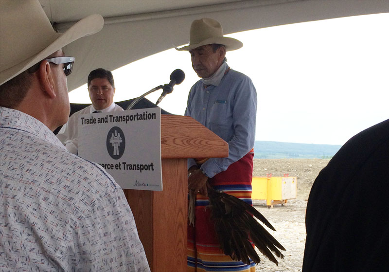
The ceremony began after an opening prayer by Tsuut’ina elder Gerald Meguinis. The prayer spoke of safety and prosperity not just for the Nation, but for the assembled guests, and for the travellers who would soon be using the road.

meguinis
Tsuut’ina Nation Elder Gerald Meguinis, giving the opening prayer.

While the Province is officially embracing ‘Tsuut’ina Trail’ as the name for one segment of the ring road, Chief Crowchild suggested taking the renaming one step further. He stated “We believe that the entire ring road can, and should, be named Tsuut’ina (Trail)” and noted the significant role that the Nation has played in helping to get the road finished.

Transportation Minister Mason was reportedly only made aware of the idea to rename the entire road within the last day or so, and was cautious, yet willing to explore the idea. “It doesn’t take a political science graduate to see the difficulty, but certainly I’m prepared to talk to the chief and if necessary, to talk to the three chiefs and the Stoney Nation as well and if they can reach some sort of agreement, I think we can too.” he said.1

IMG_3991
Tsuut’ina Nation Chief and Council. L-R: Darrell Crowchild, LeeRoy Meguinis, Andrew Onespot, Chief Lee Crowchild, Lyle Dodginghorse, Vincent Crowchild, Leon Littlelight, Kelsey Big Plume.

Regarding the official renaming, Mayor Nenshi stated “I can’t think of a better name for this important piece of infrastructure than Tsuut’ina Trail. It is a reminder of our common path as neighbours and fellow citizens,”.2

Herald-28-1-81

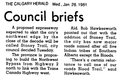
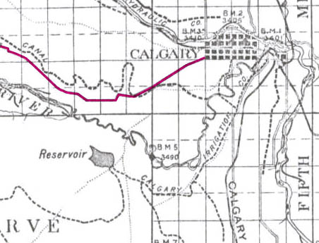
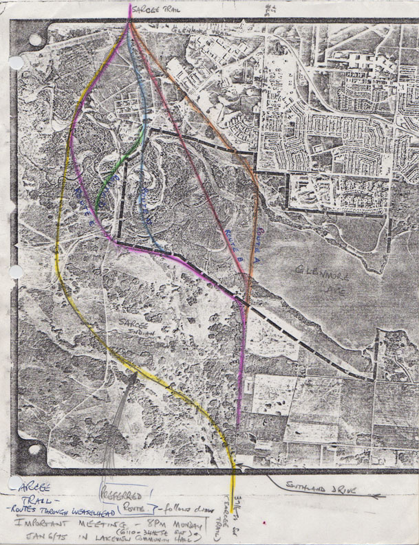
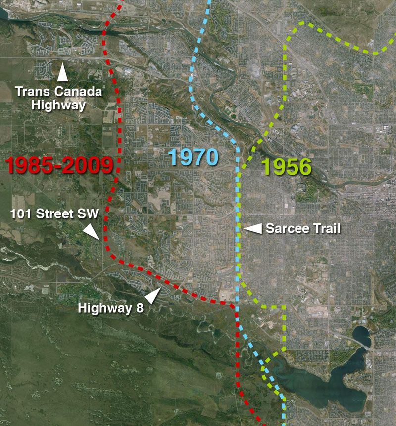
Calgary’s ring road was first officially named ‘Stoney Trail’ in January of 1981, by Calgary’s City Council when the road project still fell under the City’s remit.3 Previous working-names for the southwest section of the road have included the West Bypass (1959), the Sarcee Trail Extension (1970) and the Southwest Connector (2003).

Continue reading “Tsuut’ina Trail Officially Named”

Advertisement

Highway 8 and the Ring Road

This month, the Government of Alberta revised the plans for the Southwest Calgary Ring Road Project by extending the western portion of the road into the Highway 8 corridor. This section of the ring road, what is currently Highway 8 from Sarcee trail to just west of the Calgary city limits and highlighted below in blue, had until recently been a part of the West Calgary Ring Road Project. This change shifts approximately 5km of roadway to the Southwest ring road, adds one additional interchange (69th street SW) and a new crossing over the Elbow River to the project, while removing the same from the West leg of the road.1

July_2015_update_new(The previous Southwest ring road route in green, with the addition of a portion of Highway 8 in blue, making up the most recent Southwest ring road alignment.2)

This section of Highway 8, between Sarcee trail and 101st street, has played an important role in the history of the ring road, not only recently, but for many years before.

South Morley Trail, Springbank Trail, Richmond Road and Highway 8

The modern Highway 8 partially follows the route of one of the oldest roads on Calgary’s west side. Richmond road, first known as South Morley Trail, was a key trail west of the city in the 19th century, and originally connected Calgary to the Stoney Nakoda First Nation Reserve via Springbank.3

1894_Richmond_Road(The Richmond road corridor highlighted in pink, 1894.3)
Continue reading “Highway 8 and the Ring Road”

Crossing the Elbow River – 1956 to 1986

The release of a ‘virtual tour’ video of the Southwest Calgary Ring Road this past week has given the public a chance to view the proposed plans for this road in a way that maps have not been able to. The detail and context provided by the video has raised concerns over the impacts the road will have on southwest Calgary, including the Elbow River, Fish Creek and the Weaselhead. The nature, size and proximity of the cut-and-fill river crossing, combined with a realignment of the rivers, appear to be at the heart of these concerns.

2014_elbow

(Source: Alberta Transportation)

The crossing of the Elbow river is arguably the most important link in the Southwest Calgary Ring Road project. This new crossing of the Elbow river in southwest Calgary, the first since the Glenmore causeway opened in 1963, is projected as being the single most utilized portion of the new road. Establishing this crossing has seen numerous proposals over the years; from a low-level bridge in the 1950s to a dam in the 1980s (creating a new reservoir upstream from the Weaselhead) to a consideration of a high-level bridge, and even talk of a tunnel, in the 2000s. A new crossing of the Elbow river is an idea that has undergone many revisions and alternatives in the decades since it was first proposed.

The first part of this story looks at the early proposals and the history of the crossing of the Elbow River, from the first proposal in 1956 to the project’s (temporary) cancellation in 1986. Part two, which looks at the modern river crossing plans and alternatives from 2000 to 2014, will follow.

Early plans: models and maps

In 1955 the Province of Alberta made public its desire to establish a bypass highway in Calgary’s southwest, and by the following year, the City had drafted initial plans for this road. Around the same time the City was also developing plans for the Glenmore Reservoir parks, and these two proposals would converge in the form of the first publicly released concept for the Southwest Ring Road, then known as the West Bypass, and its crossing of the Elbow river.

The ambitious plan for the proposed Glenmore Parks, containing an aquarium, a solarium, botanical gardens, an ‘Indian Village’ and more, was estimated to cost $3 million and would take upwards of 25 years to implement. When the City’s planning department was seeking approval from both the public and the City Council for the proposed park system surrounding the Glenmore Reservoir, they created a model of their proposed ideas. Along the western portion of the model lay the West Bypass, and its crossing of the Elbow river was presented to the public for the first time.

na-5600-8138a

(Glenbow Archives NA-5600-8138a. Click for an enlargement of the Elbow River crossing)

The crossing, depicted as a 4-lane low-level bridge of about 180m in length with some amount of cut-and-fill on the north bank of the valley, was only conceptual at this stage. Detailed work on the entire development had yet to be carried out at the time of the model’s creation, and no engineering had gone into the designs at this point. (The road is shown along the bottom of the photograph above). Continue reading “Crossing the Elbow River – 1956 to 1986”

West and Southwest Calgary Ring Road Virtual Tour

On August 25 2014 the Province of Alberta released 3D Virtual Tour renderings of the West and Southwest Calgary Ring Road projects.

Southwest Calgary Ring Road Project:

West Calgary Ring Road Project:

Click for more information on the 2013 Southwest Ring Road deal (plus updates in March 2014 and June 2014), and the History of the Southwest Ring Road. For more information on the history of the West Calgary Ring Road, Click Here.

Ring Road Update June 2014

The Provincial Government today released the functional design plans for the West and Southwest Calgary Ring Road project. Starting at the Bow river crossing of Stoney trail NW and heading south to Macleod trail at Highway 22x via the Tsuut’ina reserve, this last section of the ring road measures 31km, contains 66 bridges, 20 interchanges and several crossings of the Bow river, the Elbow river and the Fish creek. A full breakdown of the details can be found here, or at the Alberta Transportation website here.

W&SW_Ring_Road

Though the new release contains little new information on the physical road itself, one of the major changes announced involves the staging of construction. While the Province and the Tsuut’ina Nation are still awaiting the Federal Government to approve the land transfer that was agreed upon last year, the Province has stated that rather than build the West leg first, as was previously announced, the Southwest leg of the road would be the first to start construction. The timelines are currently unchanged from earlier estimates, and it is hoped by the Province to have a contractor awarded and construction begun in 2016.

Other key points:

• 80,000-100,000 cars are projected to use certain sections of the road.

• Data from the 2013 flood is being used to evaluate the bridge designs, to ensure they will “accommodate future flooding events of a similar magnitude”.

• A P3 financing model is still being evaluated, and a decision will be made upon the completion of a business case advocating for or against such a model.

• 2 million cubic metres of rock and 5 million cubic metres of dirt will be moved to create a path for the road up the Paskapoo Slopes, beside Canada Olympic Park.

• According to the most recent available plans from 2008, The Elbow river valley at the Weaselhead will be filled from the current width of about 1000 metres wide down to 90 metres wide, with the remaining gap to be bridged. The fill height and road will range from between 5 to 15 metres (16 to 50 feet) above the current valley floor.

• An environmental assessment by the Province is reportedly underway, either in addition to, or as a continuation of, the environmental assessment begun in 2006.

• Public information sessions are planned for the fall or early winter of 2014.

Maps of the West Calgary Ring Road (from North to South)

Highway 1 (Trans Canada Highway), Valley Ridge blvd NW, and the twinning of the existing Stoney Trail bridge over the Bow river:

11_WCRR_TCH_VRidge_small

Continue reading “Ring Road Update June 2014”

90th Avenue and the Southwest Ring Road

First appearing on plans together nearly 60 years ago, and shown as connected in every major road plan since, 90th avenue SW and the Southwest Calgary Ring Road have a long and inseparable history. The connection of these two roads together, initially planned out of convenience, and later out of necessity, continues to play a significant role in the history of the ring road. Calls to keep 90th avenue from being connected to the ring road have been heard in recent years, and it is important to understand the history of this road, and why the connection of 90th avenue is seen as an indispensable part of the ring road plan.

The Origins of 90th Avenue SW

1953_90th

90th avenue is an arterial road in Calgary’s southwest, south of the Glenmore Reservoir, that has existed in some form or another since the early days of the City. Early settlers in the region traveled its path to access their land, and by the early 20th century, a dirt road had been created which served a small number of homesteads in the area. This arrangement, pictured above in 1953, went largely unchanged for many years. When the foreseeable encroachment of an expanding City of Calgary finally necessitated it, bigger plans for the road were initiated.

Forward Planning and a Growing City

In the early to mid 1950s the City had begun to more fully embrace a civic planning program; one that was more forward looking than had been undertaken in decades. The City was creating plans for areas that were then rural, but would one day be developed as part of a rapidly-growing City. The earliest modern plan for 90th avenue can be traced back to 1953 when the City created it’s earliest internal Ring Road plan. 90th avenue SW between Macleod Trail and 37th street SW was at that time an integral part of the Ring Road, and formed the southern portion of the City’s first complete Southwest Calgary Ring Road route.

1953-highlight

(Source: Untitled Map. December 1953. City of Calgary Corporate Records, Archives. Board of Commissioners S. IV box 189 F. 39.)

This configuration did not last long, and soon the main Ring Road route continued south, beyond 90th avenue SW. By 1956 a masterplan for the development of parks around the Glenmore Reservoir was developed by the City (shown below), and included a modified 90th avenue SW proposal. These plans mark the first time that plans for the Southwest Calgary Ring Road and 90th avenue SW were shown to the public.

Glennore_1956Then called ‘South Glenmore Drive’, 90th avenue was depicted much as we know it today, running from 14th street SW to 37th street SW, where it connected directly to the ring road. This basic layout was retained in Calgary’s first approved transportation plan, 1959’s Calgary Metropolitan Transportation Plan (shown below as 92nd avenue).

1959_90th Continue reading “90th Avenue and the Southwest Ring Road”

From No to Maybe: The turning point for the SW Ring Road, part 2

This article follows on from the previous article, From No to Maybe: The turning point for the SW Ring Road, part 1.

—–

By the close of the 1970s, the Tsuut’ina Nation and the City of Calgary seemed to be at an impasse regarding the Southwest Calgary Ring Road (or the Sarcee Trail Extension, as it was then known). Though generally indicating resistance to the idea of allowing a road through the reserve, the Nation nonetheless had been willing to continue to engage with the City in discussions, noting that any chance of success hinged on the Nation deriving certain benefits from the road. The City meanwhile had seemingly made it clear that they were not prepared to entertain certain requests of the Nation, particularly access from the ring road to potential developments on the reserve, and the extension of City utilities to those developments.

1984_reserve_view

At the same time, and in a seemingly contradictory move, the City had begun to limit itself from building the road along a route through the Weaselhead area within the City limits, thus ensuring that it needed to acquire land from the Nation in order to build the road. Though conditions to this point had not yet been right for progress, both parties seemed to be heading towards a middle ground, and information and cooperation were the last hurdles to clear before the story of the ring road could move forward. Continue reading “From No to Maybe: The turning point for the SW Ring Road, part 2”

Ring Road Update March 2014

The recent release of the 2014 Provincial Budget brought with it some new details regarding the funding of the Southwest Calgary Ring Road. In addition, the Province has released some initial timing and staging details regarding the implementation of the road, including the possible division of the road into two separate construction projects.

ringroad_march_2014

The Budget and the $5 Billion Price Tag

Released on March 6, the 2014 Alberta Budget sets aside $2.698 billion towards both Calgary and Edmonton’s ring road projects over the next three years. Of this, Finance Minister Doug Horner noted that $1.8 billion is to be dedicated to the Southwest Calgary Ring Road. In an address on March 7 to the Calgary Chamber of Commerce, Minister Horner reportedly stated that the full construction of the remaining portion of Calgary’s ring road would cost around $5 billion. The decision to deliver the project via traditional delivery or through Public Private Partnerships has yet to be made, and the Province is currently “investigating the viability of delivering the final segment of Calgary’s ring road in two separate projects using the Public Private Partnership (P3) procurement process” Continue reading “Ring Road Update March 2014”

From No to Maybe: The turning point for the SW Ring Road, part 1

The approval of a ring road agreement between the Tsuut’ina and the Province of Alberta in October of 2013 has opened the door for the long-planned Southwest Calgary Ring Road to be built through what is currently the Tsuut’ina Nation reserve. By any measure, the vote to accept the deal was overwhelmingly in favour, but the idea of selling reserve land for the freeway has not always been a popular one amongst Nation members.

With a deal now agreed to locate the ring road through the reserve, a once formidable divide between the idea of retaining reserve land and selling it has seemingly been bridged, but what changed? Why has that idea of selling the land, once thoroughly rejected by Tsuut’ina members and leadership, now been embraced?

Ring Road Planning

Although Calgary had planned for a ring road from as early as the mid-1950s, the early designs would have seen limited, or at times non-existent, incursions into the Tsuut’ina reserve. Early designs were proposed to be largely located within Calgary’s city limits, and while there have been sporadic discussions between the City and the Nation regarding the acquisition of land for a road, in the early days these talks would appear to be perfunctory.

It wasn’t until the 1970s that more considered thought was given to planning the Southwest Calgary Ring Road through the Tsuut’ina reserve in a substantial way.

1975_ROUTE_F Continue reading “From No to Maybe: The turning point for the SW Ring Road, part 1”

The West Calgary Ring Road

Though the route of the southwest ring road through the Tsuut’ina reserve has in recent years garnered the most attention of the unfinished portions of Calgary’s bypass network, there are actually two additional pieces of infrastructure needed to complete the ring. Aside from the south leg, which extends the road to Macleod Trail in the south, there is also the West Calgary Ring Road, defined as the portion of the road that connects the Trans Canada Highway to Highway 8. This is the piece that I will cover here.

Early West Side Planning

1956-2009_west_ring_road

The earliest complete plans for a ring road around Calgary, dating from 1956, plotted much of the western leg of the circuit along the 53rd street SW corridor, better known today as Sarcee Trail. While the route to the north and south of this leg would undergo revisions, this western portion would remain largely unchanged for nearly 30 years, and the road would continue to be planned along the Sarcee Trail corridor until the mid 1980s. Continue reading “The West Calgary Ring Road”