
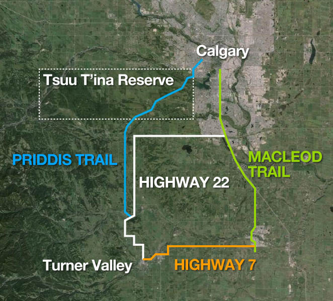
The Southwest Calgary Ring Road may be the best known provincial road designed to cross Tsuu T’ina land, but it wasn’t the first road sought through the reserve. In fact, it is at least the fourth road, either built or not, that the Province planned to cross the reserve. The three previous road plans, of which only one is operating today (and one never built), are also related in another way; they were all earmarked at one time or another to be the route of Highway 22.
The Priddis Trail and the Original Highway 22
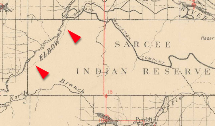
The road known as the Priddis Trail was not only the first road to be considered for the role of Highway 22, it actually predates the building of that highway by many years. The road was officially established by the Province in 1900 after being surveyed for the first time in 1899. However, the route is even older than that. The Priddis Trail was set out along a much older trail that had been in use by local First Nations for decades, if not centuries. The trail is shown below in 1897.

The land for the road was surrendered at no cost by the Tsuu T’ina (then Sarcee) at the request of the Province, and the route quickly became well traveled, being the only road between Calgary and the Priddis and Millarville regions at the time.
By the end of the 1920s the Province was looking to improve the roads that served the booming oil fields south of Millarville in the Turner Valley area; roads which were then in a state of chronic disrepair. The oil fields were typically accessed via the Okotoks-Turner Valley road, later known as Highway 7, but the condition of the road often rendered it impassible. The Province moved to not only improve this main heavy-equipment route, but also to establish an alternative gravelled road to take the light traffic off of the main corridor.
In seeking a secondary route to the oil fields, the Province looked first to the Priddis Trail. This dirt road was already being used to access the Turner Valley area, and the original plan would have seen the entire Priddis Trail, from Turner Valley and Millarville all the way into Calgary, improved and designated as Highway 22. By July of 1930 the road had been graded from the south as far as the Tsuu T’ina reserve, where work stopped. Around this time the decision was made to route Highway 22 not through the reserve, but instead branching east near Priddis to join up to the Macleod Trail at Midnapore. This change of route was reportedly due to the reserve itself; the road was moved away from the ‘long unoccupied stretch of country on the reserve’ and instead it was routed through the farming areas to the south, along what is now Highway 22x.
Before the route was changed, it was reported that Province was to ‘straighten’ the portion of the Priddis Trail through the reserve, and to ‘bring it up to standard’. Of course any change in the route of the road would have required more land from the Nation, whereas the eventually-selected route followed an existing Provincial road allowance, which travelled a straight line between Priddis and the Macleod trail south of Midnapore. The Province spent over $101,000 to construct Highway 22 from Midnapore to Millarville in 1931, with additional construction and gravelling work continuing for several years following.
With the new Highway 22 in place, the Priddis Trail was essentially abandoned by the Province and soon fell into disrepair. By contrast, Highway 22 was lauded for its robust construction and its ability to withstand heavy use and tough weather conditions. In the mid-1930s culverts were removed along the Priddis Trail and the road began to deteriorate; the Province’s maintenance efforts seemingly shifted to the new Highway 22. By the early 1940s the Province had erected signs indicating that the Priddis Trail had been closed, though limited use of the road continued to be made until the bridge over the Elbow River was finally damaged beyond repair in 1959.
After several failed attempts to regain title to the road in the 1940s, the Tsuu T’ina were finally successful in seeing the majority of this land returned to the reserve in the early 1980s. Only the small portion of the road contained within the Weaselhead park remains in the control of the City of Calgary. For a more in-depth history of the Priddis Trail, click here, and for more on the settlement of the remaining Priddis Trail land claim, click here.
Bragg Creek and Highway 22
The main road that runs to Bragg Creek, and through the western portion of the Tsuu T’ina reserve, shares in common the basic roots of the Priddis Trail: it too was originally a trail established by the First Nations of the area before european homesteaders first settled, and before the Tsuu T’ina reserve was established. Known as the ‘Stoney Indian Trail’ by pioneers of the Bragg Creek area, the trail (mapped below in 1897) was well used by members of the Stoney Nakoda First Nations and was part of a trail network that connected Rocky Mountain House with the area around Fort Macleod.
The route, later known as the Bragg Creek Road, had seen increased use by homesteaders as a wagon trail around the turn of the century, and as early as 1912 the Province of Alberta had examined the route with an eye to establishing it as an official Provincial road. In 1921 a 66-foot-wide corridor for the road was surveyed, and the next year the province had reached an agreement with the local Indian Agent on a price of $20 per acre for the purchase of the land through the Tsuu T’ina reserve. Despite formalizing the road and making improvements to it, the land deal had not been completed and no payment was made at the time. It wasn’t until the Province needed more land from the Tsuu T’ina that a deal for the entire corridor was entered into.
Record floods in the summer of 1932 washed away the bridge over the Elbow river in Bragg Creek, the third bridge to be washed out in that spot since 1913. A new bridge was to be constructed downstream from the original location, in the place where the current bridge still stands, and the newly relocated bridge required a small portion of land from the Tsuu T’ina reserve to accomodate the approach road. This approach ‘diversion’ will be familiar to those that have traveled through Bragg Creek, as it forms the junction of Balsam Avenue and Highway 22, and has resulted in a small isolated triangle of the Tsuu T’ina reserve across from the Shell station.
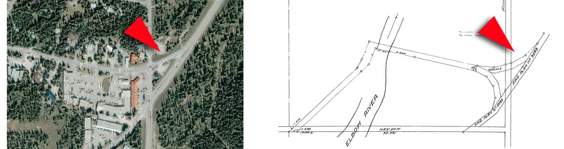
The approach road was surveyed in 1932, and by 1934 the Secratary of Indian Affairs sought to establish from the local Indian Agent if the earlier price of $20 per acre would be still suitable for both the original right-of-way and for the new portion of the approach. A final price of $881.40 was agreed to between the Province and the Department of Indian Affairs, and the 44.7 acres of land was formally transfered to the Province. This land was expropriated from the Tsuu T’ina reserve under section 48 of the Indian Act (1927), and no consent of surrender from the Nation is on record with the transfer documents.
By the 1950s the Province was seeking to make improvements to the road, including widening and straightening sections through the Tsuu T’ina reserve. In 1955 the Tsuu T’ina band council approved a Provincial proposal for acquiring a wider corridor for the road through the reserve, and a price was agreed to for these additional lands. In 1956, following the survey of a new 99-foot-wide right-of-way, the Province returned the entire original corridor to the Federal Government, and the following year a deal was finalized for the Province to purchase all of the land for the new road. Despite the return-and-repurchase arrangement, the new corridor was largely the same as the original corridor, though wider and straighter in parts.
This agreement had been approved by the band council, and the Province paid $2124.00 for the land, now totalling 64.57 acres. By the time the transfer had taken place, the Province had already widened and reconstructed the road.
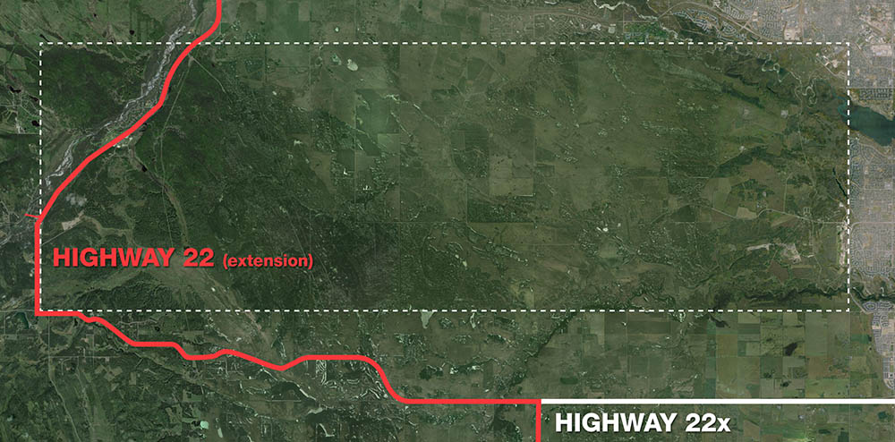
In the 1970s the Province had begun a program of extending the existing Highway 22, and had settled on making the Bragg Creek Road a part of that highway. Known as Provincial Highway 762 into the early 1970s, the Bragg Creek Road would soon be given the temporary designation of Highway 922, before being officially designated as a part of Highway 22 in the mid 1970s. The road is still known by that designation today.

The road would not only open a path through the reserve, but also help open up opportunities on the reserve as well. In the early 1970s the Tsuu T’ina Nation created a development plan that would leverage not only their land, but also the access provided by the Provincial highway through their reserve. The community of Redwood Meadows, located north of Bragg Creek on leased reserve land, consists of around 350 private homes and a golf course located between the Elbow River and Highway 22, and is accessed directly off of the Highway, as are the Tsuu T’ina rodeo grounds. In 1998 the Nation revealed longer-term, though as-yet unrealized, plans to build a casino resort along the highway near Redwood Meadows.
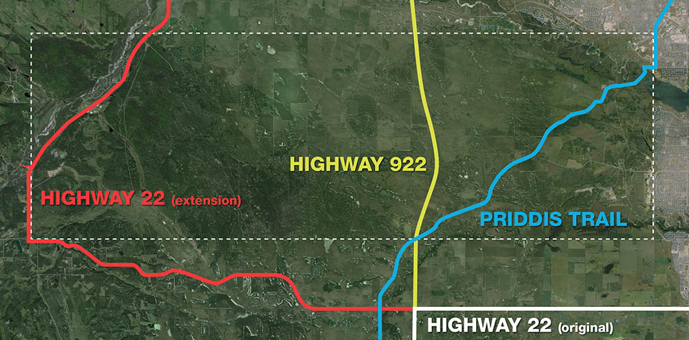
Highway 922
Before the Province had decided on extending Highway 22 via the Bragg Creek Road, another route was briefly planned for the Highway extension. In the mid 1960s, the Province had begun to plan for another road to be a possible northern expansion of Highway 22, and like it’s predecessors and descendants, this one also would have also crossed the Tsuu T’ina reserve.
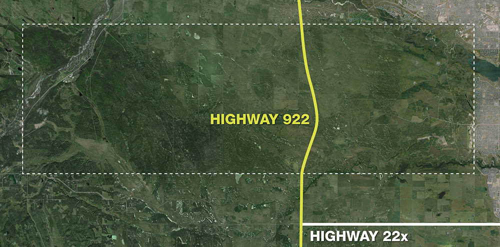
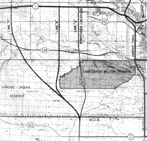
In 1965 the Province began a program of ‘rural road studies’ that would plan for future local road and highway needs throughout the province. This resulted in a series of Secondary Road Study Reports, including several that focused on the Calgary area including the Municipal Districts of Rocky View and Foothills. These reports, along with the ‘Calgary Area Study’ undertaken in 1970, identified the need for a new North-South highway west of Calgary. The Study detailed three potential routes for this road, then known as Highway 922, and recommended one as a potential extension of Highway 22. This road would have continued Highway 22 north from Priddis, bisecting the reserve through it’s centre, and connecting with Highway 559 (now Highway 8) and the Trans Canada Highway.
The more direct version of these alignments was seen by the Province as providing the greatest utility to drivers; the likely destination of Calgary for most travellers would mean that the more easterly route would see the greatest use. This view was seemingly shared by the Tsuu T’ina, although the Nation had reportedly not been directly contacted about the road by 1970. Engineering consultants retained by the Tsuu T’ina to study the development potential of the reserve were contacted by the Province at this time, and sought their views on the suitability of the proposed alignments. The consultants indicated that Nation residents might find value in a road out of the reserve to the north, in order to better access Calgary, while the alternative western-most alignment “would not have any significant value to them.”
An account of Highway 922 is recalled in Patricia K. Wood’s excellent article A road runs through it: Aboriginal citizenship at the edge of urban development. ‘Tsuu T’ina Band Councillor Bruce Starlight recalls discussion of a road began even before his father became a chief in 1966, and that there were two suggestions: “First, they wanted to put a road right through the middle, where my brother-in-law’s house is, right through the middle of the reserve, to hook up with Highway 8, which at that time was just a dirt road … Lately, it’s been 37th Street.”‘
Another factor in studying these alternatives was the ability to cross the Department of National Defence’s artillery range, located on reserve land leased from the Tsuu T’ina. As shown in the map above, the preferred route would have crossed a portion of this leased range. While the Province had written to the DND regarding the use of this land, the matter was still outstanding when the report was published, and alternatives were kept open in case the DND would not allow for this road crossing. The more westerly proposals, while of less utility to potential drivers, would have avoided the training grounds.
When the Province moved the route of Highway 22 to Bragg Creek in the mid 1970s, the original Highway 922 bisecting the reserve was rechristened as Highway 768. This change was short lived, and soon the plan to run a road through the middle of the Tsuu T’ina reserve was abandoned entirely.
Later resistance by the Tsuu T’ina Nation to running a road more centrally through the reserve would prove to be a challenge for the Province when developing plans for a future ‘outer’ ring road; a challenge that the Southwest Calgary Ring Road would be called upon to solve. The Province’s ongoing plans for an outer ring road will be covered in a future article.
One Last Road?
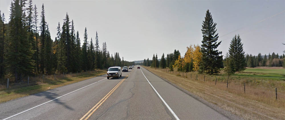
Today the existing Highway 22 north of Bragg Creek can serve as an example of how a Provincial road through the reserve can work, and how its long-term uninterrupted access has the ability to provide benefits to both aboriginal and non-aboriginal populations alike. For travellers and local residents the road functions as an efficient path through the reserve, and for the Tsuu T’ina the access provided by the road has opened up many diverse economic opportunities. This model may well echo the situation regarding the Southwest Calgary Ring Road by providing benefits for all involved, so long as a suitable deal can be made.

I just found your blog, and am looking forward to wandering through the history of this area by reading your excellent stories!
I wonder what the future of Redwood Meadows will be when it comes time to renew the lease!? We (the owners of properties in Hidden Valley, Siksika Nation) were not successful in renewing our lease. In hindsight, that was a good thing as the Bow River has completely destroyed our community.
I’m glad you found the blog, and that it can be of some value!