
This is the fourth and final part of my overview of the Calgary Ring Road project, covering the period from 2000 to the current day. In many ways this is the period that moved the full ring road project from concept to reality. Despite a small portion having been built in the previous decade, work on a high-capacity, free-flowing provincial highway got underway in earnest after the turn of the millennium; work that is still ongoing today. (Click here for Part 1: 1956-1970, here for Part 2 1974-1976, and here for Part 3 1980-2001) As always, click on any of the maps for a larger view.
BECOMING A PROVINCIAL HIGHWAY
In 2000, the City of Calgary and the Province of Alberta signed an agreement that transfered the control of both the Deerfoot Trail and Stoney Trail to the Province. Despite the road originating in Provincial plans, and being primarily designed by the Province since the 1970s, the Calgary ring road had to this point been a City road.

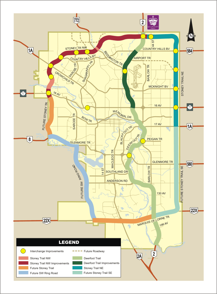
By the close of 2001, Stoney Trail had been constructed between the Trans Canada Highway and Country Hills Blvd in Northwest Calgary. The road at this time had traffic lights controlling its intersections, and with some portions being only a single lane in a given direction, it was suitable only as an arterial city road. The Province, however, had for many years planned the ring road as a free-flowing, multi-lane provincial highway. Once the road was under the jurisdiction of the Province, moves were made to upgrade it to this higher standard of thoroughfare. The first part of this plan required a revision to the long-term plan for the road.
An Updated Plan
In 1996 a City of Calgary Functional Planning Study was completed on the entire Northwest portion of the road, including portions still unconstructed at that time. In 2001 the Province wanted to ensure that the plans for the road were still suitable in the face of population growth and land-use changes, so Earth Tech (Canada) Inc. was hired to update the 1996 plan. The resulting “Stoney Trail – Trans Canada Highway to Deerfoot Trail Functional Planning Study ” completed in 2003 not only detailed the initial build of the ring road, it also laid out the ‘Ultimate Stage’ of Stoney Trail, including future road widening up to 8 lanes, and the design of all required interchanges (some of which that are still yet to be built).

STONEY TRAIL EXPANSION PROJECT 2004-2009
On May 9 2003, Prime Minister Jean Chrétien and Premier Ralph Klein announced a funding agreement between the Federal Government and the Province to pay for the expansion of the ring road system, a project known as the Stoney Trail Expansion Project (STEP). The Federal portion of the funding amounted to $75 million towards the original $250 million total budget for the project, with the Province initially committing the remaining $175 million.

The STEP, as laid out in the 2003 study, would entail building a new, 15km section of road to extend Stoney Trail from its then-terminus at Country Hills Blvd all the way to Deerfoot Trail. The project would also upgrade the existing 7.5km portion to a consistant 4 lanes for the entire length of the Northwest portion and remove many of the signalised intersections in favour of free-flow interchanges (Though the inclusion of new signalised intersections ensured that the road would still not be a fully free-flow road once the extension project was completed).
Northwest Upgrades
In early 2005 construction on the Stoney Trail Extension Project began. At the start of construction, the plan called for the existing signals at the Trans Canada Highway, Crowchild Trail, Scenic Acres Link and Country Hills Blvd to be removed and replaced with free-flowing interchanges. The new section would have an interchange at Deerfoot Trail, as well as new signalised intersections at Sarcee Trail, Beddington Trail and Harvest Hills. The existing signalised intersection at Nose Hill Drive was to remain and a flyover (with no access to or from Stoney Trail) was to be built at Shanappi Trail.

(Photo showing the Northwest portion of the road, courtesy Ayrcan on Flickr)
After construction began, the plans for the intersections at Sarcee Trail and Beddington Trail were revised, and the traffic signals were replaced with free-flow interchanges. In addition, a right-in right-out access was opened at 14th street NW, the Crowchild Trail interchange was modified from the original design to accomodate the LRT extension to Tuscany, and ramps were added to the North side of the Shaganappi Trail flyover for improved, but still limited, access. The deadline for finishing the NW section of the ring road was initially set for late 2007, however overruns meant that construction schedules had to be extended, caused in part by the revisions and additions to the initial plans. This later meant that the Northwest portion of the road was opened in stages as they were completed, rather than waiting for the entire road to be opened at one time.
The final price tag for the Stoney Trail Expansion Project was $460 million, up considerably from the original $250 million budget. According to then-Alberta Transportation spokesman Bart Johnson, rising labour, matterial and fuel costs were blamed for two-thirds of the increase in the budget, while changes in scope for the project accounted for the other third.
The $75 million contribution from the Federal Government remained unchanged, and so the Provincial expenditure more than doubled, from their original $175 million to a final contribution of $385 million.

The opening ceremony of the Northwest and Northeast Stoney Trail projects, November 2 2009. (photo courtesy of Mazrim at skyscraperpage.com)
On November 25 2008 the section from Country Hills Blvd to Sarcee Trail was opened to the public, followed by the opening of the section from Sarcee Trail to Harvest Hills Blvd on July 10 2009. The final section, from Harvest Hills Blvd to Deerfoot Trail was opened on November 2 2009, nearly two years after the initial deadline. The opening of this last section coincided with the opening of the entire Northeast section of the road, which was the next portion of the project undertaken by the Province.
Despite the successful completion of the Stoney Trail Extension Project, the Province has continued to improve the Northwest portion of Stoney Trail in the years since. The signalised intersection at Harvest Hills Blvd was replaced with an interchange in 2010, The Shaganappi Trail intersection was converted to a full interchange, and in 2011 construction began on the Nose Hills Drive interchange (Due to open in 2014). On August 10 2012, the last set of trafic lights were removed from the Nose Hill Drive intersection, whereupon the entire of Stoney Trail became free-flowing, apart from the lights at the end of the road at 17th Avenue SE.
THE EAST FREEWAY
In 2006 a Functional Planning Study prepared for the Province on the entire east portion of Stoney Trail was completed by Earth Tech (Canada) Inc. Despite eventually being constructed in two distinct phases, as the Northeast and Southeast Stoney Trail projects, these portions were planned in a single comprehensive study. Previous to being designated as part of Stoney Trail, this portion of the road had long been called the ‘East Freeway’.

NORTHEAST STONEY TRAIL
On February 22, 2007, The Northeast Stoney Trail (NEST) project began with the appointment of the Stoney Trail Group to design and build the northeast portion of the ring road under a P3 agreement. The group, led by Bilfinger Berger BOT Inc., includes Flatiron Constructors, Parsons Overseas Company of Canada Ltd., Graham Construction and Earth Tech (Canada) Ltd., among others.
The awarded P3 contract was worth a total of $930 million, with $300 million to be paid upfront by the Province, and $21 million per year for the 30 years after construction is completed. (The total of $930 million was calculated by the Province to have an effective price of $650 million in 2007 dollars). This contract for the design, building and maintenance of the Northeast ring road also included the maintenance of the entire Northwest section. Construction began in April of 2007 with a 20 month schedule, and completion was contractually due no later than November 1 2009.

The 21km Northeast segment of the road (shown above in red) finished the entire north section of Stoney Trail by running 4-6 lanes from Deerfoot trail, due east to approximately the 78th Street NE corridor, then due south to 17th avenue SE. Starting at Deerfoot Trail, interchanges were provided for at Metis Trail, Country Hills Blvd, Airport Trail/96th Avenue, McKnight Blvd and at 16th Avenue NE/Trans Canada Highway. Unlike the previous section of the road, all of the interchanges on the Northeast portion were designed to be free-flowing from the outset, and traffic signals were not used on Stoney Trail itself, apart from where the road terminates at 17th avenue SE. These signals will remain until the Southeast portion of the road opens, which is slated to occur in 2013.
The Northeast ring road was opened on November 2 2009, along with the final segment of the Northwest ring road portion. This meant that by the close of 2009, approximately 45% of the entire ring road project was completed and open to the public. In addition, since the road now had interchanges with 16th avenue on both the east and west sides of the city, the road was now functional as a true Trans Canada Highway bypass. In many ways, the completion of this section of the road fulfilled one of the oldest (though not functionally the most important) objectives that the ring road system was designed for, that of a Trans Canada Bypass.

Northeast Stoney Trail looking south

Stoney Trail and Deerfoot Trail interchange under construction (both photos courtesy of Freeweed at skyscraperpage.com)
SOUTHWEST RING ROAD: 2004-2012
In 2004, the Province and the Tsuu T’ina Nation signed an Agreement in Principle with regards to planning and constructing the Southwest ring road through Nation land. Up until this point, negotiations for a Sarcee Trail extension south of Glenmore Trail had been handled generally by the City of Calgary (Despite the concept of this portion of the road first originating with the Province, and the many studies and designs for this road prepared by the Province). Although the City did set up committees to contribute to the negotiations, from 2004 the Province and the Nation were the only parties directly involved in the Southwest ring road process.

On March 11 2005, Premier Ralph Klein and Chief Sanford Big Plume signed a Framework Agreement which set the stage for the negotiations over every aspect of the deal. In June of 2005, a Functional Planning Study was initiated by Trans Tech, and formal designs were started. The agreement called for an 8-month negotiating timeframe, with a call to conclude ‘Final Agreements’ by November of 2005, and the agreement to be brought to a vote of the Nation by no later than September 1 2006. The agreement allowed for the timeline to be extended by agreement of both parties, and the final vote by the Nation did not occur until almost 3 years after the initial deadline.

The full Functional Planning Study with the final road design and construction cost estimates was largely completed in 2007. An independant valuation for the land required for the road was originally slated to be ready in 2006, and after being delayed for over a year, a draft report of the appraisal for the land was delivered to both parties in December of 2007. This appraisal would form the basis of much of the compensation for the land deal, and a final compensation package was set at $275 million in cash plus a land swap of 4858 acres in exchange for the 988 acres needed for the road.
(Details of the Opening Day road design can be found here, and the Ultimate Stage design can be found here. A review of the 2009 ‘Final Agreements’ can be found here)
With the road designed, the required land identified, compensation (generally) agreed upon and a shared desire to proceed, the deal was taken to the members of the Tsuu T’ina nation, and a vote was conducted on June 30 2009. The deal was turned down by 60.5% of the voting membership, and thus the agreement failed. (More on the deal that was voted down, and identified reasons for the failure of this deal can be found here)
Southwest Options?
With five years invested in a process that reportedly cost the Province $6 million, the government decided to conclude negotiations, and pursue an ‘Plan B’ for the Southwest portion of the ring road; an alternative that did not require any land from the Tsuu T’ina Nation. By the end of 2009, the Province and the City signed a Memorandum of Understanding to study building the ring road along the 37th street corridor, entirely through City land.

The province publicly launched their ‘Plan B’ public consultation in January of 2011, when five alternative routes for the Southwest ring road were presented. Concerns over the affects that such a road would have on developed areas of the City (such as Lakeview, Glamorgan, Oakridge, Eagle Ridge etc.) as well as environmental impacts on the Weaselhead and the Glenmore Reservoir were raised, and an environmental and community group, Save Glenmore Park, was formed to dissuade the notion of building the road along 37th street. The opposition to the proposed ‘Plan B’ alignments included not just local residents and park users, but also included Calgary Mayor Naheed Nenshi, Ward 11 Alderman Brian Pincott and Calgary-Elbow MLA (and soon-to-be Premier) Alison Redford, among others.

June 2011 Information Update Session hosted by Save Glenmore Park (photo by Mike Ridewood, courtesy of Save Glenmore Park)
In June of 2011, at the height of community opposition (which was by no means universal) to the Province’s ‘Plan B’ alternatives, the Tsuu T’ina Nation took a poll of their members, and with a result of 68.5% in favour, they voted to re-open negotiation with the Province. The Province welcomed the Nation’s vote, and in less than a month, the ‘Plan B’ alternatives were put on indefinite hold, and negotiations with the Tsuu T’ina had resumed. By September 2012, negotiations were said to be going well, and Chief Sanford Big Plume was ‘very encouraged’ by the negotiations. (More about the Province’s ‘Plan B’ can be found here)
WEST AND SOUTH RING ROADS

The West and South ring roads are smaller segments of the ring road project that would tie the existing (or under construction) legs of the road into the Southwest ring road. The West ring road (pictured above) extends the existing Stoney Trail from it’s terminus at the Trans Canada Highway near Canada Olympic Park south to Highway 8 along the 101st street SW corridor. This 7.5km long segment would interchange at Old Banff Coach Road, Bow Trail and 17th Avenue SW, before connecting into the Southwest ring road. TransTech Focus was hired to complete the Functional Planning Study for the road, and in June 2009 recommended alignments and interchanges were presented.
In 2010 there was some speculation by Transportation Minister Luc Ouellette that completing this portion of the road, before the final alignment of the Southwest ring road had been determined, could be considered. However, the Calgary Herald quoted ring road project lead Garry Lamb in 2008 as saying “The intersection at Glenmore Trail is designed to accommodate the Southwest ring road, so that deal will have to get done first.” In addition to this challenge, cost would become something of a sticking point, especially in relation to it’s benefit. In the fall of 2012 Mr. Lamb stated that the West leg of the ring road would be particularly expensive to build, owing to the large amount of earthmoving required to extend Stoney Trail up the hill to the south of Trans Canada Highway interchange. The West leg would be required to handle the increase in traffic that would accompany a connection into the deep south via the Southwest ring road, but until the Southwest portion was built, and until traffic volumes increased, it would likely remain unbuilt.

The South portion (above) of the ring road is again a smaller section of road that serves to tie the Southwest portion to the Southeast portion of Stoney Trail. This section of road features not only the four interchanges along the ring road path itself, at Macleod Trail, 6th Street SW, James McKevitt Road and Highway 22x, but also continues west of the ring road route, and includes three interchanges to service the proposed Providence development. (The designs shown for the South portion also include the interchange at Sun Valley Blvd, although this was later included in the Southeast portion of the road, and the Macleod Trail interchange was originally slated to proceed without being tied to the rest of the South portion of the road. However, as of August 2013, the Macleod Trail interchange has been put on hold, with the province opting to upgrade the existing infrastructure instead.)
SOUTHEAST RING ROAD
The most recent section of the road to begin construction is Southeast Stoney Trail (SEST). With the land required for the road already in the hands of the Province, and having already been designed in conjunction with the Northeast portion, the Southeast leg of the road was in a good position to begin construction. The province put the contract for the road out to tender in March 2009, and was then finalised a year later. On March 30 2010 the P3 contract was awarded to the Chinook Road Partnership (a partnership of construction companies led by SNC Lavalin Inc.).

The 34-year P3 contract was valued at $1.226 billion ($769 million in 2010 dollars), with the government of Alberta contributing $232 million and the Federal Government contributing $100 million towards the construction phase. Monthly payments of $2.5 million would be paid to the Chinook Road Partnership over the 30 years following completion, both to pay for the road and to finance the 30 year maintenance contract built into the P3 agreement. A traditional-delivery estimate for the road produced by the Alberta Government pegged the same project at $1.8 billion in 2010 dollars. The P3 contract also included maintenance of 12km of Deerfoot Trail; from Stoney Trail south to the interchange with Highway 2A just north of Okotoks.

(Deerfoot Trail/Cranston Road/Seton Blvd interchange, June 2012, photo courtesy Chinook Roads Partnership)
The Southeast portion of the road is approximately 25km long, and is being built with 6 lanes along it’s entire length. The most southerly portion of the Southeast ring road has existed as Highway 22x for many years, and along that stretch, the existing road would be upgraded and integrated into Stoney Trail. There are 9 interchanges along Southeast Stoney Trail, at 17th Avenue SE, Peigan Trail, Glenmore Trail, 114th Avenue SE, Highway 22x, 52nd Street SE, Deerfoot Trail, McKenzie Lake Blvd/Cranston Blvd and Sun Valley Blvd/Chaparral Blvd, before officially terminating a few hundred feet east of Macleod Trail. An additional interchange that is not directly on Stoney Trail is also being built as a part of the project. The Deerfoot Trail/Seton Blvd/Cranston Road interchange is located about 2km south of Stoney Trail.
With the contract awarded, construction began in 2010, and is set for an October 1, 2013 opening date. The completion of the Southeast Stoney Trail project will see 70% of the entire ring road finished.
In 2011, the Macleod Trail interchange, including 6th Street SW, was proposed by the Province as an upgrade that could be completed independently of the Southeast or South ring road projects, and Aecom was hired to undertake design work. Though originally expected to begin work in the winter of 2012 (with a Fall 2014 completion), the project was sidelined in August of 2013, with upgrades to the existing infrastructure to take place instead.

(Stoney Trail and Deerfoot Trail interchange under construction, July 2012, photo courtesy Chinook Roads Partnership)
THE MISSING PIECE
With only the Southwest portion of the road outstanding, by the end of next year Calgary will have a three-quarter ring in place. With negotiations ongoing for that final section, time will tell what, or indeed if, transportation solutions will be implemented to finish the ring.

The Cranston exchange is laughably bad, and will create more problems than not including exits in the first place. It is overly complicated, and just for the sake of being complicated. It’s obvious to me that nobody involved in the project will be inconvenienced by haveing to use this white elephant themselves.
I think it’s worth remembering that the ring road is a Provincial facility, and is designed as much to facilitate Provincial bypass and inter-urban traffic as it is to provide intra-urban/commuter trips. This balance of uses combined with a high-speed specification meant that certain requirements would have been favoured over others, and the road could never have been all things to all people. (In other words, including more turning movements in some of the southern interchanges would have required slower speeds, more bridges or wider spacing between interchanges in order to avoid dangerous weaving areas on the road.) I have not seen an example of complexity being implemented simply for complexity’s sake, it typically has a purpose, even if that purpose is not immediately clear.
I understand there were concerns with too many exits and the rate of speed at which the flow of traffic was going to be traveling. I live in the area and had hoped that the ring road would allow for an easier commute than what I was currently facing on the Deerfoot. I feel somewhat cheated out of the ability to use this new road and have been relegated to continue using the inefficient Deerfoot as a result.
Unfortunately the ring road from the north will likely be of little use to folks who live in Cranston and McKenzie lake. Cranston has no direct access to Stoney with the exception of a westbound on ramp. The south Deerfoot exit from Stoney passes the Seton Blvd exit completely, and the only other choice for Cranston residents traveling westbound Stoney is an additional 5 kms of traveling and backtracking (adding traffic),through two left turns (third highest cause of collisions in Alberta) at the Sundance overpass. McKenzie lake residents have an additional set of lights and left turn. This not only adds to the yearly fuel costs faced by these residents and government fleets, but frustrations as well. I believe the added costs and safety concerns to this commute outweigh the concerns of an on ramp within a certain distance of another.
Any traffic intending on leaving Cranston and south McKenzie lake to head south on Deerfoot are now required to go through the community to the other entrance. In McKenzie lake this is a semi major road with two lanes, but also a school zone and a Playground zone. In Cranston there are also two 30 kmph zones, but the road is a single lane. Commuters working south of the city from these areas face longer commutes and roads not designed for the traffic.
As a bypass the Stoney will be brilliant, but it also means that a good amount of the westbound traffic at 52nd street, will not be on Stoney at the Cranston overpass. I feel this would have made a multi-lane merge at Cranston a feasible option. Only time will tell in that respect I guess.
There will eventually be other options (52nd St), but at the moment traffic heading to the health campus from westbound Stoney only have access through Auburn bay, and that means two Playground zones. I feel that this limits to a certain extent the response times for both Ambulances as well as the Fire trucks. Being that the South Health Campus will likely be helping families to the east of Calgary, and indeed most of the SE communities, funneling this traffic onto 52nd St seems a bit silly at the moment. I can only hope that 52nd St planned in a way that will facilitate that much commuter and emergency traffic, and more to come as more communities in the SE develop. There are current safety concerns with the layout, but I can only speculate at the safety concerns faced when 52nd St is in its final form.
I agree that there will be factors that I will never be fully aware of in the design of this interchange, but I can speak to the current layout and the frustrations it has caused already.