

First appearing on plans together nearly 60 years ago, and shown as connected in every major road plan since, 90th avenue SW and the Southwest Calgary Ring Road have a long and inseparable history. The connection of these two roads together, initially planned out of convenience, and later out of necessity, continues to play a significant role in the history of the ring road. Calls to keep 90th avenue from being connected to the ring road have been heard in recent years, and it is important to understand the history of this road, and why the connection of 90th avenue is seen as an indispensable part of the ring road plan.
The Origins of 90th Avenue SW

90th avenue is an arterial road in Calgary’s southwest, south of the Glenmore Reservoir, that has existed in some form or another since the early days of the City. Early settlers in the region traveled its path to access their land, and by the early 20th century, a dirt road had been created which served a small number of homesteads in the area. This arrangement, pictured above in 1953, went largely unchanged for many years. When the foreseeable encroachment of an expanding City of Calgary finally necessitated it, bigger plans for the road were initiated.
Forward Planning and a Growing City
In the early to mid 1950s the City had begun to more fully embrace a civic planning program; one that was more forward looking than had been undertaken in decades. The City was creating plans for areas that were then rural, but would one day be developed as part of a rapidly-growing City. The earliest modern plan for 90th avenue can be traced back to 1953 when the City created it’s earliest internal Ring Road plan. 90th avenue SW between Macleod Trail and 37th street SW was at that time an integral part of the Ring Road, and formed the southern portion of the City’s first complete Southwest Calgary Ring Road route.
(Source: Untitled Map. December 1953. City of Calgary Corporate Records, Archives. Board of Commissioners S. IV box 189 F. 39.)
This configuration did not last long, and soon the main Ring Road route continued south, beyond 90th avenue SW. By 1956 a masterplan for the development of parks around the Glenmore Reservoir was developed by the City (shown below), and included a modified 90th avenue SW proposal. These plans mark the first time that plans for the Southwest Calgary Ring Road and 90th avenue SW were shown to the public.
 Then called ‘South Glenmore Drive’, 90th avenue was depicted much as we know it today, running from 14th street SW to 37th street SW, where it connected directly to the ring road. This basic layout was retained in Calgary’s first approved transportation plan, 1959’s Calgary Metropolitan Transportation Plan (shown below as 92nd avenue).

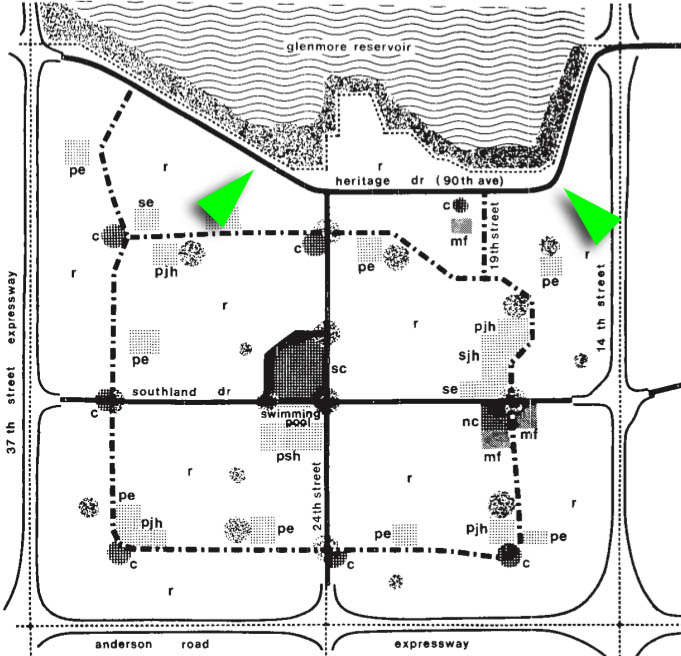
In late 1959 the route of 90th avenue was modified in a new and unique way: rather than terminating at 14th street, the road was shown to continue in a north-easterly direction through what is now Glenmore Landing, and connecting directly into Heritage drive. This combined route continued to appear on City documents into 1966, when the first development plan was prepared for the future communities of Oakridge, Bayview, Pump Hill, Palliser, Cedarbrae and Braeside (below). Though potentially providing greater connectivity for the City’s road network, this plan was not to last long.
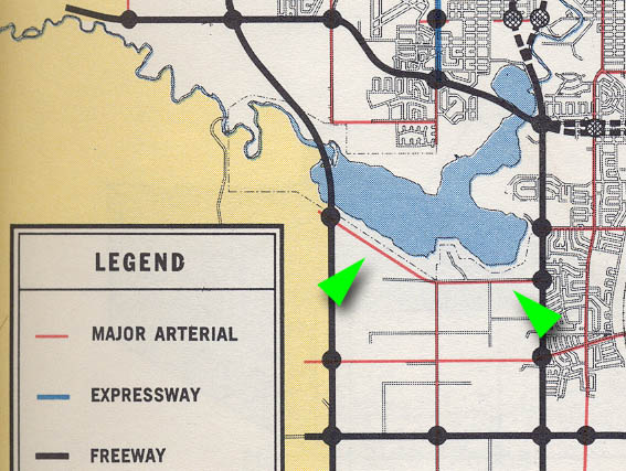
 The following year the City’s next major transportation study was undertaken (shown below from 1967). The route for 90th avenue had reverted back to existing only between 37th street and 14th street, and this basic layout would be followed into construction.
 From Plan to Reality
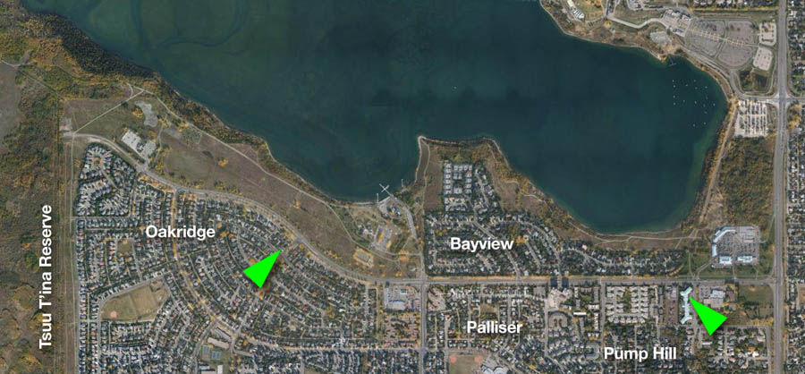
In the late 1960s and early 1970s the City of Calgary constructed 90th avenue as we now know it, in conjunction with the development of the communities of Palliser, Pump Hill, Bayview and Oakridge.
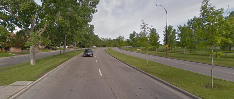
Traffic volumes on 90th avenue are not uniform across its entire length; the further west it goes, the less use it sees. From a peak of about 25,000 cars per day near 14th street, the usage of the road drops to about 3,000-6,000 cars west of 24th street. Despite this wide range in volume, 90th avenue was constructed as a consistent 4-lane divided road along its entire length. This uniformity is the result of the planned connection to the ring road; while on the west end of 90th avenue the road is currently only a local access road and sees only light traffic, the road was built to handle the increased traffic that would result from ultimately being connected to a freeway on the west.
The Needs of the Nation
Though a connection between the ring road and 90th avenue has long been seen as a necessary link in the City’s road network, the importance of this road in the story of the ring road increased dramatically in the 1980s. The unique benefits that 90th avenue could deliver to the Tsuut’ina meant that the road would play a key role in negotiations for the ring road.
When the Southwest Calgary Ring Road (also known as the Sarcee Trail Extension) was first studied in detail in the mid 1970s, and the possibility of routing the road through the Tsuut’ina reserve was first addressed in earnest, the issue of how the Nation could benefit from such road was not part of the discussion. According to then-Mayor Rod Sykes, City Administration was unwilling to extend utilities to reserve land adjacent to the ring road. It was felt that providing utilities would spur developments on the edge of the city, outside of the City’s ability to plan or control it. In addition, the Administration was reportedly convinced that the City could never recoup utility and servicing costs associated with a ‘satellite city’ that fell outside of the City’s jurisdiction and tax base.
In short, the City wanted the road to serve Calgary, but without also serving the Nation in the form of development accommodation. Without the ability or resources necessary to develop reserve land included in a ring road deal, Nation officials rejected the idea of running the road through the reserve.
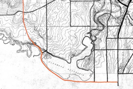
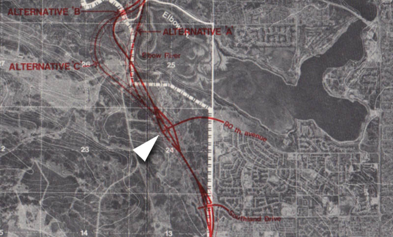 After lying dormant for several years, in 1982 the City, Province and Tsuut’ina, agreed to co-fund a joint study of not only the ring road, but also of the potential development opportunities that the ring road could provide to the Nation. By this time the City was willing to entertain requests by the Nation regarding access and services in order to get a deal done, and the study concluded with a route selected through the reserve (in 1984, shown above), as well as a thorough review of the potential for development on Tsuut’ina land. This review included suggestions of using the land for residential, recreational and commercial endeavours by the Nation, with retail shopping concepts being a primary focus in several potential scenarios.
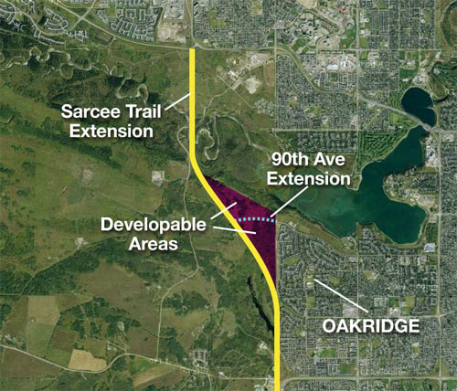
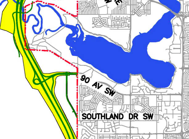
The study focused on a 300 acre parcel of reserve land directly west of Oakridge (shown below), which would be bisected by 90th avenue. Potential customers for Tsuut’ina developments would gain access to proposed commercial ventures only via 90th avenue, making this connection essential if development were to occur. (Click here for more information about the 1984 study, including proposed development potential adjacent to Oakridge.) With the study complete and the requirements of the Nation understood by all parties, the Nation voted to enter into formal negotiations regarding selling reserve land for the ring road.
 The statement was clear to those who heard it; without a connection to the ring road from 90th avenue and access to future developments along that road, there would be no deal to locate the ring road through the reserve. Despite this mandate, there continued to be calls to stop 90th avenue from connecting to the ring road.
To Connect or Not to Connect
In 2005, following the signing of an agreement-in-principle with the Tsuut’ina Nation, the Province began the process of designing the Southwest Calgary Ring Road, which included consultation with the public. In the early stages of the design process there were calls to abandon plans to connect 90th avenue to the ring road by local residents living near the road; calls that were supported by Ward 11 Alderman Barry Erskine among others. This request was made in part to maintain the quiet nature of 90th avenue west of 24th street and to ensure that communities along its length would not be subject to increased congestion or cut-through traffic. Though by no means universal among local residents, concern over the potential for increased traffic meant that the 90th avenue connection was singled out for more detailed analysis and discussion by the City of Calgary.
Concerns from residents and Aldermen were not just limited to the connection of 90th avenue to the ring road; also at issue was the connection of 90th avenue to future Tsuut’ina developments. One Oakridge resident summed up their position in feedback provided at a ring road open house in 2006 by stating “The connection of 90 Ave SW to the ring road to permit the Tsuut’ina band to develop its complex (mall) beside the Weaselhead can only serve to exacerbate the traffic congestion on 90 Ave and 14 St. City of Calgary representatives should stop trying to downplay this problem. The city and the province are making it possible for the natives to profit from their development. However, they are sacrificing the communities that are located next to 90 Ave… Serving as the sacrificial lamb to placate the natives is not a pleasant role.”
The city and the province are making it possible for the natives to profit from their development. However, they are sacrificing the communities that are located next to 90 Ave…
Worry about the impacts that a commercial development would have on traffic near residential communities spurred a City Council committee to recommended that the City consider studying the connection of 90th avenue or Southland drive to the ring road without a connection to future Tsuut’ina developments.
In response, Tsuut’ina representative Morten Paulson stated “The notion that a ring road and its connectors would be built that would service 250,000 Calgarians, but that would deny access to Tsuut’ina citizens to use that road, is offensive.” Paulson made clear the importance of the connection on the future of Tsuut’ina developments, and of the future of the ring road itself: “In order to build businesses, you need traffic. Our customer base is, of course, the City of Calgary… If city council passes a motion that stops or restricts access to one of those thoroughfares… Tsuut’ina would be forced to reassess if it still wants to proceed with the construction of a ring road,”.
When the issue came before the City Council in January of 2006, council defeated the motion to restrict the road connections in this way, and voted to ensure that land for both 90th avenue and Southland drive was protected in order to facilitate connections to both roads. This did not calm the concerns of some local residents, though it firmly established the City’s position over the ring road connectors in the area.
Necessity of Connection
While the Tsuut’ina had their reasons for wanting a connection between the ring road and 90th avenue, the City and Province continued to have their own.
The Province and the City had made it clear that a connection to the ring road in the vicinity of 90th avenue was critically important. Both levels of government had cited the need for a connection of some kind in this location in order to facilitate the future residential growth of southwest Calgary, while pointing out that previous development of the area had been done on the understanding that 90th avenue would connect to the ring road. Although a ‘no connection’ option was entertained early on, this was dropped and several alternatives for this connection were eventually presented to the public which included 90th avenue, Southland drive, or both.
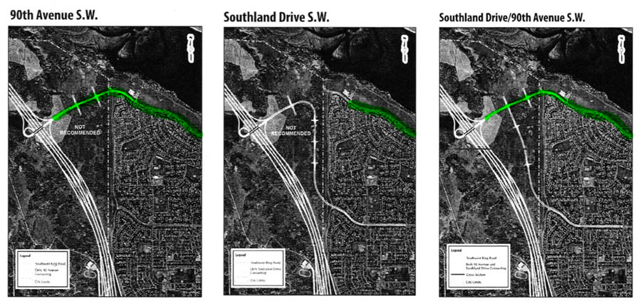
The Province recommended a unique design that included a single interchange between the ring road and both 90th avenue and Southland drive; roads that had traditionally been planned to connect to the ring road separately. Much of the reason for including both of these connections was due to projected traffic patterns on the local road network. Long-range traffic projections indicated that connecting only 90th avenue would eventually attract over 27,000 cars per day on 90th avenue west of 24th street, up from a current 3,000-6,000 cars. Connecting both 90th avenue and Southland drive would reduce this number to a projected volume of around 16,000 cars per day by spreading the volume between the two roads, as well as creating a more robust and redundant local road network that would theoretically take some pressure off an already heavily used 14th street.
A Deal is Reached
 When the final design of the Southwest Calgary Ring Road was presented to a vote of the Nation in 2009 (and again in 2013), the two-road design, featuring both 90th avenue and Southland drive, was included. To further make certain that these road connections would be built, they were formally integrated into the 2013 agreement between the Province and the Tsuut’ina (route shown above).
The inclusion of these roads in the agreement meant that the construction and ongoing connection of both 90th avenue and Southland drive to the ring road and future developments in the Tsuut’ina reserve is now binding. According to the contract, failing to build or maintain access along these roads would trigger the return of the entire ring road corridor back to the Nation.
Provided the federal government agrees, when the road corridor is transferred to the Province and construction begins on the Southwest Calgary Ring Road, 90th avenue looks set to finally stretch all the way between the ring road and 14th street as was first planned in 1956.

Yes lets make sure that 90th is connected to the ring road.
Don’t give in to the cry’s of Bay view what about Woodbine people we had no say in the ring road. thanks
Ed.
I don’t think Bayview has the problem as this road goes right past my gate at Oakmount Court. What are the plans for the intersection at Oakmount and 90 th? Since 90 th was the deal breaker with the Indians can the homes along 90 th have anything to say about the traffic control.
Probably not that would be discriminatory
Hope the City has learned lessons from the past re: the $$$ spent over the past 40 years maintaining a 4-lane divided 90th past 24th. I think they have (see Country Hills at Metis). From a funding perspective, would make sense for the developer to pay for the currently needed road but to put in trust an amount for the widen road.
Map-geek note: who was the hippie in 1966 that used sans-serif lowercase font on the South Glenmore plan?