
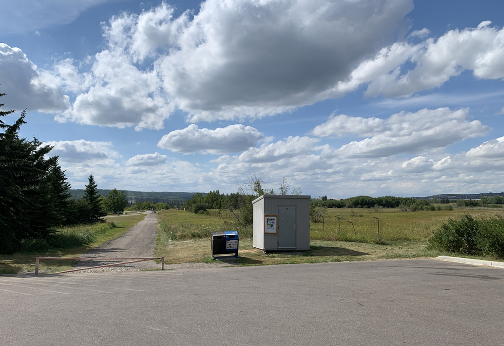
One day you may find yourself taking a walk in Calgary’s North Glenmore Park, along a pathway that connects a small parking lot to an expansive overlook of the Elbow river valley. Along that walk you would be forgiven for thinking that you were still within Calgary city limits, and that the land you were crossing was owned by the City. It’s an easy mistake to make, and it is one that has been made in one form or another for over 100 years. This unassuming land, measuring only half a hectare or 1.25 acres in area, was quietly taken from the Tsuut’ina Nation over a century ago, but continues to be claimed by the City.
A close look at the history of this ‘disputed parcel’ shows an unusually complex past, and reveals the improper dealings that led to the land being removed from the Tsuut’ina Nation reserve. By exploring this story we can see the understandable, yet shaky, assumptions on which Calgary claims of ownership this land, and perhaps recognize that it may be time for it to be returned.
To understand how the City of Calgary came to ‘own’ this land, we first have to look at the history of this part of the world, and the surprising use of this disputed parcel as part of an old Provincial highway.
(I recently had a short interview with the CBC regarding the disputed parcel, it can be found here.)
Back to the Beginning
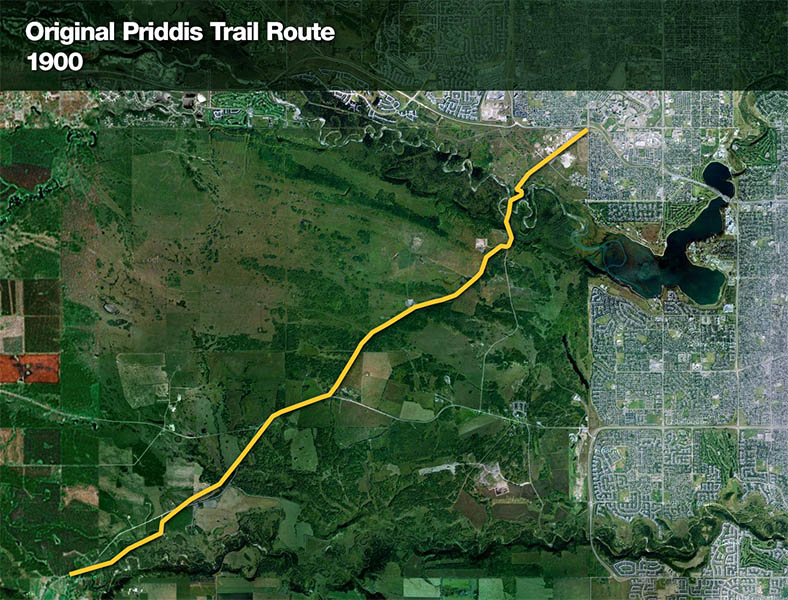
In the early years of European settlement of western Canada, homesteaders living in the Priddis and Millarville area, in what was then the North West Territories of Canada, relied on an old trail to access Calgary. This trail headed southwest from the city and crossed the Tsuut’ina Nation (Sarcee) reserve, and was reportedly in use since before the reserve was established in 1883.01 This dirt trail was not formally constructed or maintained, and suffered from chronically poor drainage; in wet years it often proved impassible for significant periods of time. As local ranchers and homesteaders relied on this route to access Calgary and bring their produce to market, the old trail was a vital link in a growing ranching district. (Read more on the history of the Priddis Trail)
The unreliability of the road was a chronic problem, and the Government of the Northwest Territories was pressed by local politicians and residents to improve the road.02 As the trail was an organically-created path that was located on Federal land reserved for the Tsuut’ina Nation, the Territorial Government wanted to acquire the right-of-way for the road before it expended any public money on improving and maintaining the road as a public highway.

Initially the matter was intended to be pursued as an expropriation of the land under the terms of Treaty 7 and the Indian Act, but the Territorial Government decided that it would be easier to instead secure a transfer agreement rather than acting unilaterally in order to take possession of the land.03
The Government of the Northwest Territories instructed its Department of Public Works to survey the road, and reached out to the Department of Indian Affairs in the spring of 1899 to seek consent for “…the transfer of the area therein contained after the survey is completed so that it may be declared a public highway.”04 That request was forwarded to the local Indian Agent to see if the Tsuut’ina Nation had any objection to the opening of the road. After discussions with Tsuut’ina Chief Bullhead, the matter was put to a meeting of the male citizens of the Nation. Informal permission was granted not only for the survey to take place, but also for the Government to improve and open the old trail as a public highway.05
“The Chief informed me the trail marked in the plan was in use by the Indians before the treaty was made with them.”
Indian Agent, Sarcee Agency. May 16, 1899.1
Securing a Surrender
In Canada, First Nation reserve land is owned by the Federal Government and reserved for a specific First Nation. Under the Indian Act, this land cannot be sold or transferred (outside of an expropriation) without the interested Nation first ‘surrendering’ their interests in that Federal land. Once surrendered, the land remains in the hands of the Federal Government until sold or otherwise disposed of in accordance with any conditions.
Over the remainder of the year 1899, the Department of Indian Affairs negotiated a formal surrender of the road corridor with the Nation. No money was offered for the land, and the Nation ultimately agreed to the Territorial Government building a road across the reserve with just two conditions.06 First, that a bridge be built over the Elbow river at the trail’s existing ‘Weaselhead Crossing’, and second was that if the Nation required the corridor to be fenced, they would not be asked to cover those costs. These conditions were agreed to by the Territorial Government, and on January 3, 1900 a surrender of their interest in the land was approved by the voting members of the Tsuut’ina Nation, a total of 21 citizens.07
When the surrender was agreed to by the Tsuut’ina Nation, the documentation did not contain a legal description of the land being surrendered, nor did it contain a formal survey of the route. Instead, the land being surrendered was indicated on an attached sketch showing the ‘approximate’ location of the existing trail.08
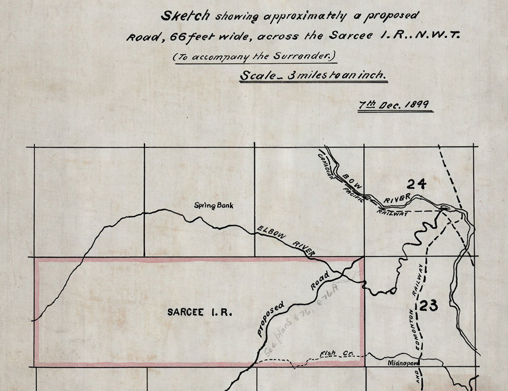
The surrender of the nation’s interests in the land was soon ratified by the Privy Council of Canada, who noted that the land was to be “…surveyed and opened up by the Government of the North West Territories as a public highway…”, though interestingly no mention of a sale was made.09 A survey would be an important step in the process, as it would serve as the legal description for the land that was surrendered for the road. In fact a proper survey of the trail had already been undertaken, but a plan showing the route had not yet been prepared by the surveyor at the time of the surrender’s ratification, and was therefore not included in the documentation.
The lack of a legal land description in the surrender documentation would cause problems for those researching and transacting with this land in the future. Anyone looking to understand what specific land was surrendered in this agreement would be forced to refer to separate survey records, as the surrender itself did not contain sufficient information to determine the extent of the surrendered lands. The ‘decoupling’ of the land description from the surrender documents would create the conditions for the original agreed-upon corridor to one day be ‘lost’ and replaced with an altered route that was not part of the original agreement.
The Original Survey and Legal Description of the Road
During the 1899 survey season, Dominion Land Surveyor A. P. Patrick undertook a survey of a 66-foot-wide corridor along the existing Priddis Trail route across the Tsuut’ina reserve. The survey data was compiled into a plan by May of 1900, and in December of the following year it was recorded as plan number 1119i in the Land Titles Office for the Southern Alberta Land Registration District.10

In an apparent oversight, the Territorial Government did not send the plan to the Department of Indian Affairs or any other branch of the Federal Government.11 This meant that there was no legal land description of the road corridor on file with the Federal Government, and nothing for those interested in the surrender to refer to when attempting to understand the extent of the surrendered lands. The Territorial Government also took no steps to have the surrendered land transferred to their ownership, apparently believing that the surrender was enough to assume ownership of the road corridor.12
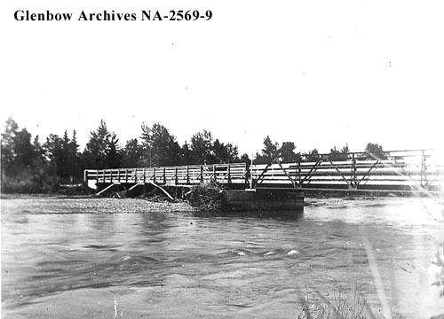
Despite not acquiring letters patent or title to the land, the Government began work on improving the existing trail. In the fall of 1900, the primary condition of the Nation’s surrender was satisfied when a new steel bridge was built over the Elbow river at the Weaselhead crossing. The old trail was being transformed into a new Government road.
Changing the Road
The new Weaselhead bridge attracted significant use upon completion, but the hoped-for improvements for the travelling public were not immediately realized. The location of the crossing was prone to seasonal flooding, and the new road and bridge were regularly damaged, washed out, or rendered muddy and nearly impassible by the spring thaw.13
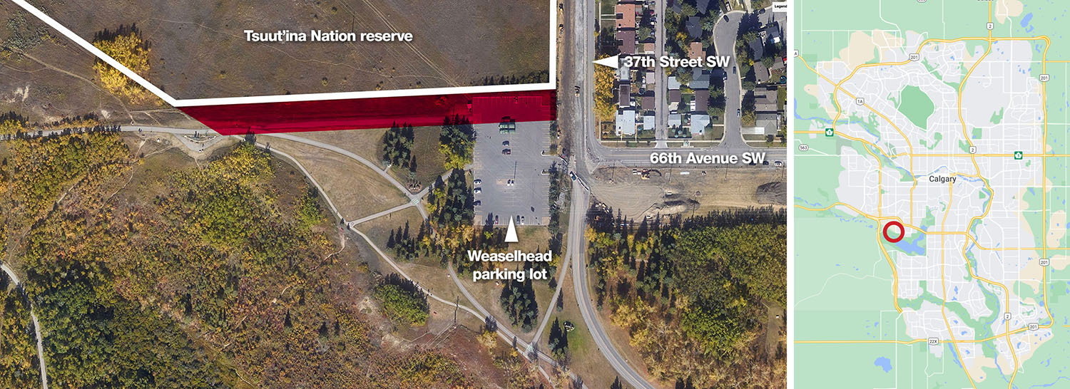
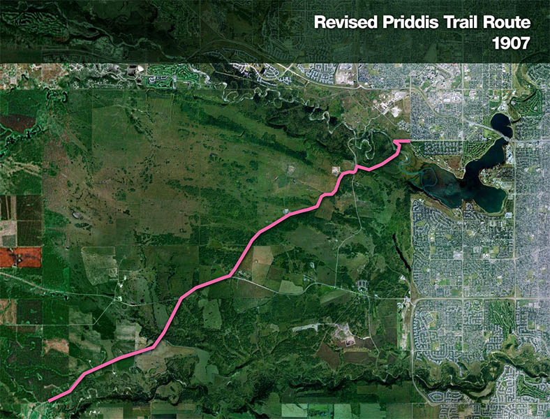
After nearly five years of dealing with repairs and maintenance, in 1905 the Government dismantled and moved the Weaselhead Bridge to what was considered a more suitable location about 1.5 kilometres downstream from the original crossing.14 This diversion was a significant departure from the original course of the road, and is the key element in understanding the future ownership of the disputed parcel. This is because the eastern-most portion of this new diversion of the Priddis Trail contains the disputed parcel.
The relocation of the road wasn’t the first time that the Government had altered the location of the Priddis Trail in those early years15, but it was the most significant; the new route diverged to such a degree that the road now entered the north end of the reserve over 1.5 kilometres from its original entrance point.

The decision to alter the location of the Priddis Trail was made unilaterally by the Territorial Government, and the portions of the road which veered outside of the original agreed-upon road corridor were constructed on un-surrendered reserve land, including the disputed parcel.
There is no record of any input or approval having been sought from Tsuut’ina citizens before this alteration occurred. By the time the Nation was asked if they had any objections, the relocation of the road and bridge had already been completed.16
Problems Arise
The change in location of the Priddis Trail would be the event that would help unearth previous mistakes made in the handling of this issue. But instead of these oversights being corrected, they were instead compounded by the questionable actions of representatives of the Federal, Territorial and Provincial Governments in the years that followed.
After the completion of the 1905 relocation, the Deputy Commissioner for the Department of Public Works for the Territorial Government, John Stocks, forwarded a survey plan of the diversion to the Federal Government, and asked for a ‘deed of surrender’ for this new land to be sent back.17 The Department of Public Works was working under the assumption that the earlier surrender would cover these unilateral changes to the location of the road18, and that this would also be sufficient to acquire title to the new land, despite not seeking the consent of the Nation nor having obtained the title to the original corridor five years previously.
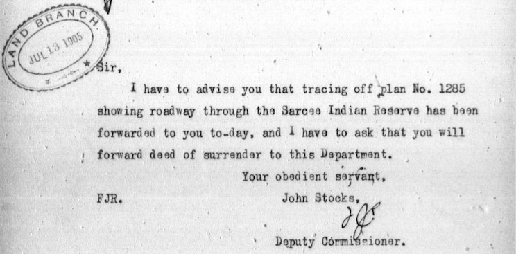
In the course of reviewing the Territorial Government’s request, the Secretary of Indian Affairs, J. D. McLean, discovered one of the earlier oversights in the handling of the land. After being presented with the survey of the new diversion, McLean had difficulty in identifying the land, responding that “The department does not appear to have been notified of the survey of the ‘Priddis Trail’, nor has any plan been forwarded showing the said trail.”19
Although the original 1900 survey was undertaken in partial fulfillment of the requirements of the surrender process, the Territorial Government’s failure to register that plan with the Federal Government was now becoming an issue.
“The department does not appear to have been notified of the survey of the ‘Priddis Trail’, nor has any plan been forwarded showing the said trail.”
J. D. McLean, Secretary, Department of Indian Affairs. August 29, 1905.
McLean requested the survey of the road to be sent over for their records, and in response, the Territorial Government sent not only the original Patrick survey of 1900, but also the subsequent diversion plans of 1902, 1904 and 1905.20 The Secretary could not make clear sense of the road corridor as detailed over the various documents, and instead returned all of the plans with a new request: for the Territorial Government to supply a single clean plan of the newly-altered Priddis Trail route. The Department of Indian Affairs was prepared to ignore the existence of the original survey, and would consider a new plan of the revised route as the ‘Final Survey’ of the road.21
‘Final Survey’
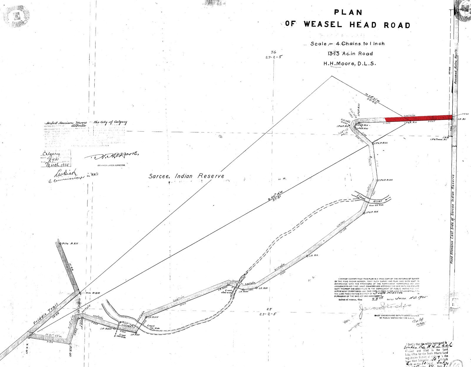
In 1907 a new ‘Final Survey’ of the Priddis Trail was commissioned by the now-Provincial Government of Alberta.22 This plan depicted the road corridor as amended by years of diversions, and was soon accepted by the Department of Indian Affairs as the official route of the Priddis Trail (which now included the disputed parcel). The plan was registered with the Federal Government as Plan 876, and would be referred to as the accepted location of this road, right up to the present day.
Slide the divider below to compare the original 1900 route with the revised 1907 route:
Upon receipt of the new survey in February of 1909, the Secretary of the Department of Indian Affairs wrote to the Provincial Government and stated that “[t]here appears to be no further action necessary, other than to convey the concurrence of this Department in the said survey, and construction and use of the road.”23 This position appears to contradict the Indian Act, which requires approval by the Governor in Council (Privy Council) to sell or transfer reserve land, even in cases of expropriation. Despite this, both the Department of Indian Affairs and the Province were satisfied that the newly divergent road corridor was owned by the Province.
Because the original surrender documentation did not contain a legal land description, and because the original survey had not been sent to the Federal Government when it was created, this new 1907 survey became the de facto description of the Priddis Trail. As the earliest survey of the road on record with the Federal Government, the 1907 survey has been mistaken by various governments and organizations for over 100 years as an accurate accounting of the lands surrendered by the Tsuut’ina in 1900, including by the Nation itself.24
To this day the original 1900 survey does not appear in Federal records, such as the Canada Lands Survey Records. The plan can only be found through the Provincial Land Titles Office, and even there, the survey only shows up in certain search methods of Tsuut’ina Nation reserve records. Because of this, the original survey remains almost entirely unknown, even to many who have researched and are familiar with this issue.
It is reasonable to conclude that portions of the road corridor, including the disputed parcel, were not legally acquired, and that the Government constructed its road on First Nation reserve land without the proper authority to do so.
Becoming a Part of Calgary
Over the next several decades the revised Priddis Trail remained in use as a public highway, though of diminishing importance. While portions of the Tsuut’ina Nation reserve located adjacent to the disputed parcel were sold, such as the City’s Weaselhead purchase in 1931 and the Military’s purchase of the 940 in 1952, the disputed parcel remained untouched and continued to be presumed as owned by the Province.25
Following the sale of the Northeast corner of the Tsuut’ina Nation reserve to the Military, the City of Calgary annexed the area26 and brought portions of the Priddis Trail within Calgary city limits for the first time. This annexation would soon lead to the City assuming ownership of the disputed parcel.
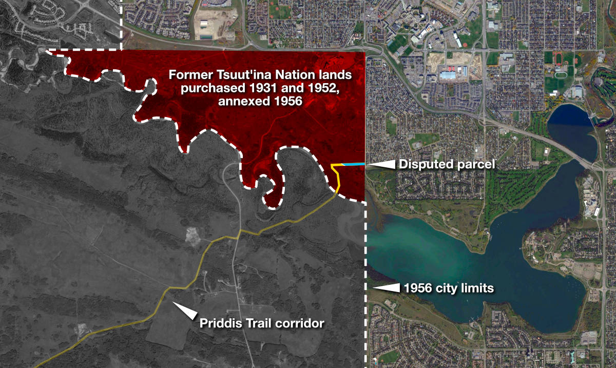
Beginning in 1968 under revisions to the Municipal Government Act, the City of Calgary became the owner of all roads within its boundaries27, and it is this authority by which the City claims ownership of the disputed parcel. Despite the Priddis Trail being declared closed in the 1930s and the Weaselhead bridge having collapsed in the late 1950s, the disputed parcel was still considered to be part of a public road.
According to the Municipal Government Act, ownership of the disputed parcel, like all roads within city limits, would automatically be vested in the City. This situation was most recently expressed in a 2007 analysis of the ownership of the Priddis Trail by Canada’s Real Property Geomatics Services. In that review, it was noted that “The 1.256 acres of Priddis Trail lying immediately Northeast of the Glenmore Reservoir remains Public Road by Plan 876 ILR… in Land Title Records . The City of Calgary is the owner of these lands pursuant to section 169 of the Municipal Government Act28.” This argument is made especially questionable by the fact that the disputed parcel was de-annexed in the early 1990s, and has not been located within city limits for over 25 years.29
The City’s claim on the disputed parcel incorrectly relies on the 1907 survey to provide a true description of the Priddis Trail surrender, and on the assumption that the Province legally acquired the land from the Tsuut’ina Nation. Without the original survey available in Federal records to contradict these assumptions, the issue of ownership has rarely been questioned.

By the 1970s, the City had partially fenced and paved the eastern portion of the disputed parcel for use as a parking lot, and its days as a public road was at an end.30
Where We Are Today
When walking along this land, its easy to be unaware of its complex past and questionable ownership. This history is not on display, and it remains largely unknown and un-discussed. It is understandable that there remains a lack of clarity over the ownership of this parcel, although the full record of the issue points to the Tsuut’ina Nation continuing to be the rightful owners of this land.

At a time when First Nations across Canada are increasingly pressing for control and ownership of traditional territory, and when municipalities such as the City of Vancouver have voluntarily returned land to its original owners, Calgary has it within its power to proactively correct this historical wrong. In an era of reconciliation, the City has a responsibility to take action.
The act of handing back this diminutive parcel may be a small one, but it would be a notable step in building trust and fostering relations between the peoples of Calgary and the Tsuut’ina Nation, who will forever remain neighbours.
Read more about the history of the Priddis Trail, the Weaselhead, and the Military’s use of Tsuut’ina Land.
With thanks to Jim Big Plume.
Footnotes
01 Letter from A.J. McNeill, Indian Agent, Sarcee Agency, to David Laird, Indian Commissioner, Department of Indian Affairs. May 16, 1899. Public Archives Canada, RG-10, Volume 3556, File 25 Pt.17.
02 See Letter from R.A. Wallace, M.L.A. for High River, to Frank Oliver, M.P. for the District of Alberta. February 14, 1899. Public Archives Canada, RG-10, Volume 3556, File 25 Pt.17, Letter from Frank Oliver, M.P. for District of Alberta to James A. Smart, Deputy Superintendent General, Indian Affairs. March 17, 1899, Public Archives Canada, RG-10, Volume 3556, File 25 Pt.17, and Letter from J. Dennis, Deputy Commissioner, Department of Public Works, Government of the North West Territories, to David Laird, Indian Commissioner, Department of Indian Affairs. April 24, 1899. Public Archives Canada, RG-10, Volume 3556, File 25 Pt.17.
03 Letter from J. Dennis, Deputy Commissioner, Department of Public Works, Government of the North West Territories, to David Laird, Indian Commissioner, Department of Indian Affairs. April 24, 1899. Public Archives Canada, RG-10, Volume 3556, File 25 Pt.17.
04 ibid
05 Letter from A.J. McNeill, Indian Agent, Sarcee Agency, to David Laird, Indian Commissioner, Department of Indian Affairs. May 16, 1899. Public Archives Canada, RG-10, Volume 3556, File 25 Pt.17.
06 Letter from J.B. Lash, Secretary to the Indian Commissioner, to Secretary, Department of Indian Affairs. July 26, 1899. Public Archives Canada, RG-10, Volume 3556, File 25 Pt.17.
07 Order in Council of the Privy Council of Canada. O.C.P.C 261. February 5, 1900.
08 ibid
09 ibid
It is important to note that the language used in the surrender and approval refers to the ‘opening up’ of the land ‘to be used’ as a road, and the ‘dedication’ of the land for use as a public highway. The words ‘sale’, ‘transfer’, ‘purchase’ or similar terms are not mentioned anywhere in the documentation. Given the lack of a formal transfer of the land, the lack of any compensation paid for the land, the lack of any reference to a land sale in the surrender documents, and Chief Bullhead’s long-standing refusal to sell off any reserve land, it is not clear that the Tsuut’ina Nation had any intention of selling the Priddis Trail corridor at all. It is possible that the Nation was approving an easement, or some other permission or agreement for the Territorial Government to build their road on land that would continue to be reserved for the Nation instead.
10 ‘Plan shewing survey of Old Trail and New Road from N.E. cor. Sarcee Indian Reserve to Millarville P.O.‘ A. P. Patrick. 1900. Plan 1119i. Alberta Land Titles, Southern Alberta Land Registration District.
11 Letter from Assistant Secretary, Department of the Interior, to J. D. McLean, Secretary, Indian Affairs. September 7, 1905. Public Archives Canada, RG-10, Volume 7736, File 23120.
12 See for instance Letter from John Stocks, Deputy Commissioner, Department of Public Works, Government of the North West Territories to J. D. McLean, Secretary, Indian Affairs. July 10, 1905. Public Archives Canada, RG-10, Volume 7736, File 23120. Letter from J. D. McLean, Secretary, Indian Affairs to John Stocks, Deputy Minister, Department of Public Works, Government of Alberta. February 2, 1909. Public Archives Canada, RG-10, Volume 7736, File 23120, and Memorandum from D.J. Allan, Superintendent, Reserves and Trusts, to W.M. Cory, Esq. Legal Advisor. Legal Division, Department of Citizenship and Immigration. January 17, 1952.
13 See for instance ‘Here and There’ Calgary Daily Herald. October 17, 1901, Notice. Calgary Daily Herald. September 11, 1902, Notice. Calgary Daily Herald. April 10, 1905, and ‘1902–36 Years Ago’ Calgary Herald. May 16, 1938.
14 Notice. Calgary Daily Herald. April 10, 1905.
15 The Territorial Government made small alterations to the course of the road near the Fish Creek area in the southern portion of the Tsuut’ina Nation reserve in 1902 and in 1904. These alterations were surveyed, and registered in the Alberta Land Title Office, but were not registered with the Federal Government.
See ‘Plan showing survey of a diversion of a surveyed trail in the Sarcee Indian Reserve’ A.C. Talbot, D.L.S. 1902. Plan 6411I. Alberta Land Titles and Surveys Spatial Information System, and ‘Plan shewing the survey of a diversion of the Calgary & Priddis Trail in the Sarcee Indian Reserve’ A.C. Talbot, D.L.S. 1904. Plan 3485AZ. Alberta Land Titles and Surveys Spatial Information System.
16 The bridge and road had already been moved by April of 1905 as detailed in the above Calgary Herald notice, while the Tsuut’ina Nation were first asked if there were any objections to the relocation in August of that year. Although no objections were made, the discussions regarding these alterations would not have constituted a formal meeting of Nation citizens that would have been required to approve any transfer of reserve land, and the lack of an objection would not have constituted a formal surrender.
See Letter from J. D. McLean, Secretary, Indian Affairs, to A.J. McNeill, Indian Agent, Sarcee Agency. August 19, 1905. Public Archives Canada, RG-10, Volume 7736, File 23120, and Notice. Calgary Daily Herald. April 10, 1905.
17 Letter from John Stocks, Deputy Commissioner, Department of Public Works, Government of the North West Territories to J. D. McLean, Secretary, Indian Affairs. July 10, 1905. Public Archives Canada, RG-10, Volume 7736, File 23120.
It is important to note that although Canadian law allowed for the expropriation of First Nation reserve land in some circumstances, permission for any transfer of First Nation reserve land would still have to be granted by the Governor in Council (Privy Council). No process of expropriation was followed for either the original corridor nor the later adjustments, and no further approvals from the Privy Council was sought nor granted for the later adjustments.
18 Letter from John Stocks, Deputy Minister, Department of Public Works, Government of Alberta to J. D. McLean, Secretary, Indian Affairs. November 21, 1905. Public Archives Canada, RG-10, Volume 7736, File 23120.
19 Letter from J. D. McLean, Secretary, Indian Affairs to John Stocks, Deputy Commissioner, Department of Public Works, Government of the North West Territories. August 29, 1905. Public Archives Canada, RG-10, Volume 7736, File 23120.
20 Letter from J. D. McLean, Secretary, Indian Affairs to John Stocks, Deputy Minister, Department of Public Works, Government of Alberta. November 21, 1905. Public Archives Canada, RG-10, Volume 7736, File 23120.
21 Letter from J. D. McLean, Secretary, Indian Affairs to John Stocks, Deputy Minister, Department of Public Works, Government of Alberta. December 6, 1905. Public Archives Canada, RG-10, Volume 7736, File 23120.
22 ‘Plan shewing surveyed road across Sarcee Indian Reserve’ J.M. Empey, D.L.S. 1907. Plan 876-CLSR-AB. Canada Lands Survey Records. (Also recorded as Plan 3432Q. Alberta Land Titles and Surveys Spatial Information System.)
23 Letter from J. D. McLean, Secretary, Indian Affairs to John Stocks, Deputy Minister, Department of Public Works, Government of Alberta. February 2, 1909. Public Archives Canada, RG-10, Volume 7736, File 23120.
24 ‘Tsuu T’ina Nation. 1931 Glenmore Reservoir Surrender. Specific Claim Submission.’ Maurice Law Barristers and Solicitors. August 16, 2004.
In this land claim filed in 2004, the Tsuut’ina Nation, through their lawyers, repeatedly referred to the 1907 survey (Plan 876) as an accurate description of the land surrendered in 1900. The claim incorrectly states that the Privy Council of Canada ‘approved’ Plan 876 along with the surrender of the land in 1900. No references to the original 1900 survey can be found in the Nation’s land claim, despite the claim directly relating to the ownership and history of the Priddis Trail.
25 In 1952 Canada’s Department of Defence sought to buy the Northeast corner of the Tsuut’ina Nation reserve, which it had leased since World War I. In the course of investigating the purchase, the ownership of the disputed parcel which crossed this land was questioned for the first time. The Federal Government’s Superintendent of Reserves and Trusts noted that although the Nation had surrendered the Priddis Trail corridor in 1900, the title to the land was never actually transferred to the Province, and was therefor not owned by the Province.
In reply to a request for a legal opinion on the matter, a lawyer with the Department of Indian Affairs stated that while the Province failed to take ownership of the Priddis Trail following the original surrender in 1900, passage the Natural Resource Transfer Act in 1930 transferred ownership of most Federal lands to the Province, including the surrendered corridor. Although a questionable opinion as it relates to this issue, all parties were satisfied that the disputed parcel was owned by the Province, and it was specifically excluded from the subsequent surrender and sale to the Military. The surrender and sale documentation only referred to the 1907 survey of the road, and no one involved appears to have been aware that the road had been relocated, or that the disputed parcel was not included in the original surrender.
26 See ‘History of Annexation’. Map. City of Calgary, Land Use Planning & Policy. Retrieved November 15, 2011, and ‘Calgary Grows Out: A Historic Look at City Expansion’ Calgary Herald. June 12, 2007. Suburbs + Satellites insert.
27 Alberta Municipal Government Act. 1968. Section 169 (2).
This section of the Act states “The title to all public highways, roads, streets, lanes, alleys and bridges in a city is, except as far as is excluded by a special Act or an agreement, vested in the city.”
28 Memorandum from Walter Volohatuke, C.L.S., Regional Manager, Public Works and Government Services Canada, Real Property Geomatics Services, to Kirsten Sellers, Claims Analyst, Specific Claims Branch, Indian and Northern Affairs Canada. Subject: Survey Report re: Priddis Trail. August 27, 2007.
29 Following the Military’s return of the 940 lands to the Tsuut’ina Nation in 1992, the City of Calgary de-annexed the area in 1993. This action removed the disputed parcel and an additional 5.62 acres of the Weaselhead area from Calgary city limits, including the entire Weaselhead parking lot and adjacent open space.
See ‘History of Annexation’. Map. City of Calgary, Land Use Planning & Policy. Retrieved November 15, 2011, and ‘Calgary Grows Out: A Historic Look at City Expansion’ Calgary Herald. June 12, 2007. Suburbs + Satellites insert.
30 ‘Calgary Imagery’ website. 1979 aerial photograph layer. City of Calgary. maps.calgary.ca/CalgaryImagery/. Retrieved November 22, 2020.

Another great article. I remember reading your piece on the Priddis Trail and you and I had a brief discussion on this disputed section of land some time ago. It was great to get more information on it.