
Modern plans have for decades shown the Southwest Calgary Ring Road as traveling through the northeast corner of the Tsuut’ina reserve. As these plans for the road had utilised land that cannot be guaranteed to be available, many have wondered why the City allowed communities like Lakeview and Glamorgan to grow right up to the city-limits, leaving no room for a ring road. With no corridor protected for this road, some have openly blamed the City for failing to plan ahead, but is this really the case?
Early Road Planning
Although there were early attempts at planning the major roadways in Calgary, notably Thomas Mawson’s plan of 1914 and the City’s 1930 Major Street & Arterial Highway plan, 1952 marked the first modern road plan for the city of which all subsequent plans are indebted. The 1952 plan (below) was the result of a push in 1948 for a masterplan for Calgary, not just for street layout but for all future growth for the city including land-use and zoning.
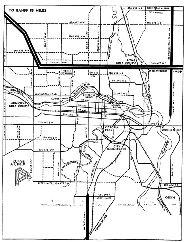
The explosion of car ownership in the post-war era had compounded congestion in the downtown core of Calgary, and the need to design a road network that would accomodate new traffic and allow drivers to avoid downtown was seen as paramount in allowing for the continuing growth of the city. Although the Major Thoroughfare Plan shows improved bypass roadways that avoid the core of the city, the proposed road network was contained within the city-limits of the time, and no regional bypass routes or ring roads feature in the plan. That state of affairs was soon to change, and beginning the following year, the City began the process of planning a ring road system for Calgary.
The Ring Road
Beginning in 1953 the City had begun to revise their road plan, and by 1956 the plan featured a series of three ring roads encircling different portions of Calgary. The ‘Inner Ring’ was set to circle the downtown of the city without actually coming into contact with that most congested of areas. The ‘Intermediate Ring’ encircled much of the developed area of Calgary, and allowed citizens living in the north and west portions of the city to access the industrial areas in the east without the need to traverse the centre of the city. Finally, and most pertinent to the topic at hand, was the ‘Outer Ring’, which was largely located outside of the existing city-limits and provided a regional road network allowing travellers on provincial highways to bypass the city entirely.
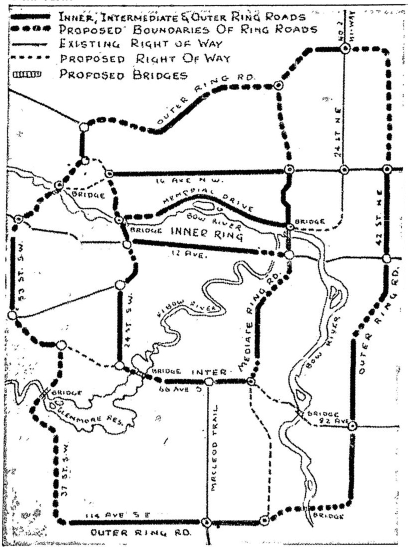
The plans (shown here from 1957) detail the southwest portion of the Outer Ring Road as a connection between Macleod Trail in the south to the Trans-Canada Highway in the west, allowing for a complete bypass of the city to those wishing not to stop at, or enter, Calgary. This road followed Anderson Road heading west from Macleod Trail, then north on 37th Street SW across the Elbow river (via what is now Lakeview) to Glenmore Trail, and then northwest (diagonally through what is now Glamorgan) and on to Sarcee Trail where it would connect to the Trans-Canada highway. At this time these plans constituted a living, working document subject to continual revisions, and as such the contents had not been endorsed by council. It would not be until 1959 that a comprehensive transportation plan for the City of Calgary would be officially adopted, by which time many important changes would have been made to the ring road plan. The results of those changes, and the subsequent planning decisions that would follow, would alter the course of ring road planning for decades to come.
Early Revisions and Why They Occured
In 1952 940 acres of the northeast corner of the Tsuut’ina reserve, located south of Glenmore Trail at 37th street SW, was purchased by the Department of National Defence (DND) from the Tsuut’ina for their Sarcee Camp military reserve, later known as the Harvey Baracks. The land had been rented by the DND since 1915 for training, when a permanent military base had been established as part of World War I efforts (and had been used for summer training a few times in the years leading up to the outbreak of war). Later, in 1956, the City had annexed significant amounts of land in the southwest in order to facilitate a growing city, and the newly purchased Harvey Barracks land was included in that annexation. With the completion of this annexation the city-limits now followed the north bank of the Elbow river in this area.
Now that the Harvey Barracks land was within the city-limits, Calgary had begun to consider the land as available for road purposes, and a more westerly road than had previously been considered could be built within the city.
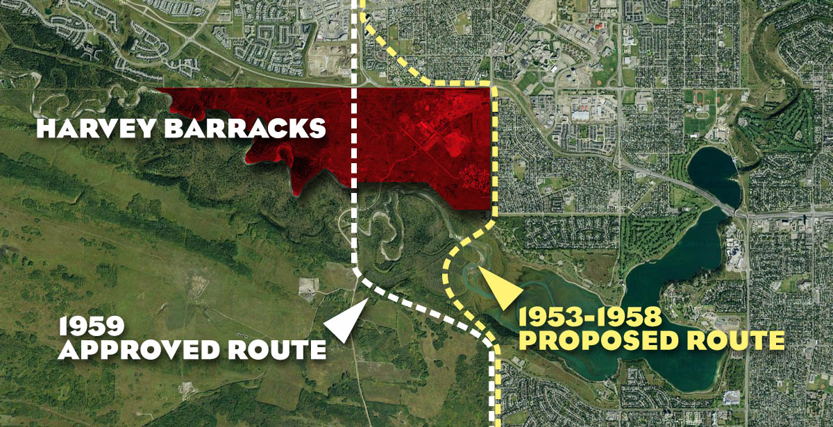
In November 1958, City Planner J. H. Eassie and Commissioner E. C. Thomas proposed a new alignment for the southwest portion of the Outer Ring Road, now called the West Bypass. The new alignment differed from the previous proposals by avoiding the future communities of Lakeview and Glamorgan altogether, and instead ran around the western edge of the Weaselhead and through the Harvey Barracks lands (shown in white above). This route, travelling through the Weaselhead and the Harvey Barracks, did not require any land from the Tsuut’ina, as it was located within what was then the city-limits. The route was approved by the City Thoroughfare Committee at its November 24 1958 meeting, and would eventually be ratified by City Council as part of the 1959 Calgary Metropolitan Area Transportation Plan, the first comprehensive transportation plan to be adopted by the City. The decision to plan the ring road through the Harvey Barracks land would prove to be a pivotal moment in the history of this road.
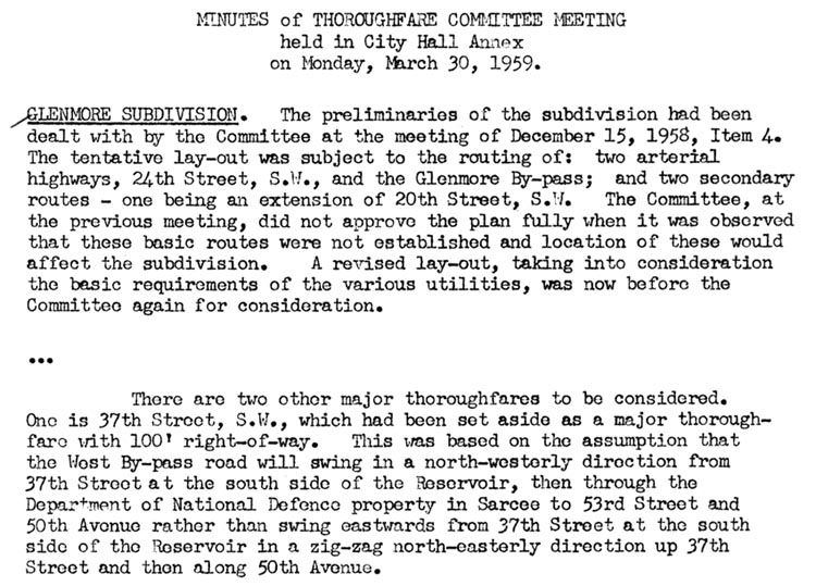
Within a few months, the design and planning of the communities of Lakeview and Glamorgan was underway. With the new routing of the West Bypass approved in principle, City planners chose to dedicate 37th street SW in Lakeview as a ‘major thoroughfare’ rather than as higher-capacity facility. The layouts of Lakeview and Glamorgan were explicitly designed on the understanding that the Outer Ring Road would skirt the Weaselhead and traverse the Harvey Barracks, and not pass through either of these new communities. An extract of the March 30 1959 minutes of the Thoroughfare Committee Meeting discussing the roads through Lakeview is shown below.
Detailed Planning and the Moving Road
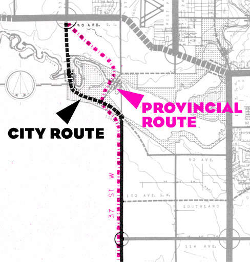
On the eve of 1959 there were actually two routes for the West Bypass under consideration: The City route which was ultimately included in the approved transportation plan, and the Provincial route, which was similar but different in significant ways. The City route continued Sarcee Trail due south from Glenmore Trail, then hugged the western and southern border of the Weaselhead on its way towards 90th avenue SW south of the reservoir. The Provincial route (shown in pink below) differed in that it headed directly southeast from the junction of Sarcee Trail and Glenmore Trail, and crossed the Weaselhead much closer to the reservoir. While the Provincial route was not originally adopted in the City’s plans in 1959, by 1963 this alignment formed the basis of the intended route, and continued to do so for many years.
The proposed Provincial route for the road through the Weaselhead had begun to cause concern among local residents and naturalists, citing environmental impacts and diminished recreational enjoyment that the area would sustain should a freeway be located through the park. By the mid 1970s the City had committed to undertake detailed study for the location of the West Bypass, known by this time as the Sarcee Trail Extension, and the study began with five route alternatives under consideration.
The Sarcee Trail South Route Location Study, as it was known, included residents and environmental groups as part of the Citizen Design Team involved in studying the proposed routes. A representative of the Calgary Field Naturalist Society had gone further than just responding to the proposed alternatives (of which a few would have required small amounts of Tsuut’ina land), and in fact suggested a new route that pushed the road further south and west of the Weaselhead area than had been contemplated by this study. This route not only crossed through the Harvey Barracks land but a significant portion was located on the Tsuut’ina reserve. Despite Chief Gordon Crowchild telling the Citizen Design Team that acquiring land from the Nation would be a complex undertaking that may never come to fruition, and despite percieved resistance to this route by the City and the consulting engineering firm of Reid, Crowther & Partners, a variation of this new route would soon be seen by the City as the preferred option.
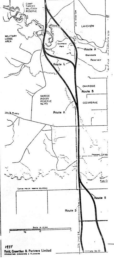
The Route Location Study concluded in 1977 without selecting a route for the road, instead recommending further study of one of the three short-listed options (‘Route K’ shown above). This proposed route through the Tsuut’ina reserve could not be properly compared to the other alignments as the City did not have access to key information required to do so. The Tsuut’ina had not formally been involved in the study process, and as a result, access to the land and other data had not been made available for study.
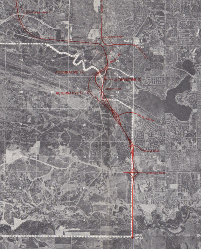
A further study was commenced in 1982, this time with the Province, the City and the Tsuut’ina as full partners. The result of this study, published in 1984, was the acceptance of the more western route that largely missed the Weaselhead area and traversed the Tsuu T’ina reserve (below). For the first time, the Nation had agreed in principle to the idea of locating the road through their reserve.
The Return of the Harvey Barracks
In 1982 the Tsuut’ina Nation began legal action to reverse the sale of the Harvey Barracks land, arguing that the sale was coerced and that the Federal Government failed to live up to it’s obligations to the Tsuut’ina. After a decade of wrangling, the Department of National Defence returned the land to the Nation in an out-of-court settlement, which would mark another pivotal moment in the history of the road. The reversion of the Harvey Barracks back into a reserve meant that a key location for the ring road, common to every ring road plan since 1959, was no longer controlled by the City or the Province. The Harvey Barracks land was again a part of the Tsuut’ina reserve, and the road as planned could not be built without going negotiating with the Nation. In addition, the routes drafted previous to 1959 were impeded by the growth of the Lakeview and Glamorgan communities; any attempt to build a ring road via 37th street SW would necessitate the removal of hundreds of homes.
Since the City and Province were committed to negotiating with the Tsuut’ina, the change in ownership of the Harvey Barracks lands did not immediately alter the planning of the road, though strained relationships would soon lead to calls for new, alternative routes that avoided the reserve land altogether.
Everything Old is New Again
In 2009 the Province proposed a road design and compensation package to the Tsuut’ina in order for the Nation to hold a plebiscite, which is required by federal law. The Nation voted against the proposed plan, and years of planning and negotiations were thrown into uncertainty.
When the deal was turned down, the Province stated that they would not seek further negotaions with the Nation, and instead would look at alternative alignments that could be built within the city-limits and which would require no Tsuut’ina land. Since the return of the Harvey Barracks lands had eliminated most of the previous 50 years worth of ‘City Only’ options, the Province and the City set their sights on the western-most corridor in the area: 37th street SW. Although officially joined by four other alternative routes as part of the Province’s ‘Plan B’ ring road options in 2011, a 37th street SW ring road proposal (below) represented the ressurection of a concept over 50 years old.
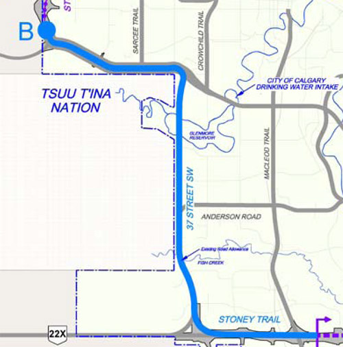
Unlike in 1958, however, the 37th street SW corridor is no longer open land; In 1959 the City had allocated only 100 feet between the city-limits of Calgary and the residential property adjoining this road on the understanding that ring road was not to use the 37th street corridor, and instead be built much further to the west.
To many observers, the time to consider a freeway in the area had passed. Some high-profile detractors of the ‘Plan B’ options, including Mayor Naheed Nenshi and MLA (and soon to be Premier) Alison Redford, had instead urged the Province to seek new alternatives or to re-engage with the Tsuut’ina in an effort to build the road through the reserve. By mid 2011 the Nation had re-asserted their willingness to talk, and the ‘Plan B’ options were shelved as the Province re-entered negotiations, which are still officially ongoing.
Planning and the Unforseen
Despite the best laid plans of the City and the Province, unforseen land ownership issues are central in understanding why there is currently no protected corridor for the southwest portion of the ring road. It cannot be said that the City did not plan for this road, nor could it be seen to be negligent in allowing communities to be built without leaving room for a transportation corridor. With modern eyes it would appear that both of these charges must be true, but with the benefit of understanding that the historic city-limits have not always been as static as they now seem, it is hard to apportion blame for the current lack of a protected corridor for this road.

It would be interesting if you could explore how parts of SW Calgary are North of NW Calgary and how the decision was made to use the river as the boundaries. Unlike the East side of the city where Memorial Dr is used. Seems Bow Trail would have been more logical. In fact up by Canada Olympic Park some 14 blocks of NW dissappear from the map. Or how about all the major roads that were never connected eg. Sarcee Tr., Barlow Tr., 14th St over the Glenmore Tr & the resivour (Very confusing if your from out of town). If the city never plans to proceed with completing these connectios they should at least change the names so as not be confused eg. SW Sarcee Tr be rename Tsuu T’ina Tr. seeing they don’t even call them selves that any more. I do enjoy the website. Thank you for taking the time to do such an extensive job.
Great blog