February 2019 Update

Although construction of the Southwest Calgary Ring Road has been ongoing for the past few years by the KGL Constructors partnership, it is not always easy to see what progress is being made. A large portion of the road is located on former Tsuut’ina Nation reserve land which isn’t accessible or visible to the average Calgarian, and as such, getting a sense of the work being done on this project can sometimes be difficult.

Last fall, Reddit user ‘Craftyshrew’ flew over Southwest Calgary and captured an image of the ring road project from the air. The cleared land along the route carves a visible corridor through the former reserve land, where the scale of the project, and the progress of construction, can be seen.

rr-air

(Image looking north from about Highway 22x. Click image for larger version)

At this stage in the project, construction has begun to some degree on all 14 of the interchanges along the Southwest Calgary Ring Road route, and grading for the mainline ring road lanes is approximately 45% completed. Bridge pilings have been started on many of the interchanges, with the rest commencing as the 2019 construction season begins.

Construction of all interchanges will continue into 2020, when the majority of the paving will be undertaken. The southwest portion of the ring road is scheduled to be open to the public in the fall of 2021.


Thank you to Craftyshrew on reddit for their kind permission to publish their photo, and to Adam Johnson and Rizwan Hussain from Alberta Transportation.

Advertisement

Tsuut’ina Trail Officially Named

Today, a new name was unveiled for the Southwest portion of Calgary’s Ring Road, between Glenmore Trail and the Fish Creek park. Tsuut’ina Nation Chief Lee Crowchild, Calgary Mayor Naheed Nenshi, Alberta Transportation and Infrastructure Minister Brian Mason and Canada Minister of Veteran’s Affairs Kent Hehr were on hand at an official ceremony to announce that the road would be known as ‘Tsuut’ina Trail’. The ring road is currently named ‘Stoney Trail’ around the rest of the city.

IMG_3960
L-R: Kent Hehr, Naheed Nenshi, Lee Crowchild, Brian Mason.

The ceremony began after an opening prayer by Tsuut’ina elder Gerald Meguinis. The prayer spoke of safety and prosperity not just for the Nation, but for the assembled guests, and for the travellers who would soon be using the road.

meguinis
Tsuut’ina Nation Elder Gerald Meguinis, giving the opening prayer.

While the Province is officially embracing ‘Tsuut’ina Trail’ as the name for one segment of the ring road, Chief Crowchild suggested taking the renaming one step further. He stated “We believe that the entire ring road can, and should, be named Tsuut’ina (Trail)” and noted the significant role that the Nation has played in helping to get the road finished.

Transportation Minister Mason was reportedly only made aware of the idea to rename the entire road within the last day or so, and was cautious, yet willing to explore the idea. “It doesn’t take a political science graduate to see the difficulty, but certainly I’m prepared to talk to the chief and if necessary, to talk to the three chiefs and the Stoney Nation as well and if they can reach some sort of agreement, I think we can too.” he said.1

IMG_3991
Tsuut’ina Nation Chief and Council. L-R: Darrell Crowchild, LeeRoy Meguinis, Andrew Onespot, Chief Lee Crowchild, Lyle Dodginghorse, Vincent Crowchild, Leon Littlelight, Kelsey Big Plume.

Regarding the official renaming, Mayor Nenshi stated “I can’t think of a better name for this important piece of infrastructure than Tsuut’ina Trail. It is a reminder of our common path as neighbours and fellow citizens,”.2

Herald-28-1-81

Calgary’s ring road was first officially named ‘Stoney Trail’ in January of 1981, by Calgary’s City Council when the road project still fell under the City’s remit.3 Previous working-names for the southwest section of the road have included the West Bypass (1959), the Sarcee Trail Extension (1970) and the Southwest Connector (2003).

Continue reading “Tsuut’ina Trail Officially Named”

2016 SW Ring Road Open Houses

KGL Constructors, the subcontractor responsible for the design and construction of the Southwest Calgary Ring Road, will be leading three open house sessions this month. Representatives from KGL, Alberta Transportation, and the City of Calgary will be on hand to present information about the project, and to answer questions about the progress and schedule of construction.

swcrr-schedule18-appa-36

2016 SOUTHWEST CALGARY RING ROAD INFORMATION SESSIONS:

Monday, November 28 (South Glenmore)
5:00-8:00 p.m.
Oakridge Community Hall, 9504 Oakfield Drive S.W.
View Google Map

Tuesday, November 29 (North Glenmore)
5:00-8:00 p.m.
Calgary First Church of the Nazarene, 65 Richard Way S.W.
View Google Map

Wednesday, November 30 (Deep South)
6:00-9:00 p.m.
Bishop O’Byrne High School, 333 Shawville Boulevard S.E.
View Google Map


SW Ring Road Contract Signed

This week the Province of Alberta and Mountain View Partners signed a Design, Build, Finance and Maintain P3 contract for the Southwest Calgary Ring Road project. Proposals for the project, which will run from Highway 8 in Springbank to Macleod Trail at Highway 22x, were invited last September, and in July of this year Mountain View Partners was announced as the preferred proponent.

The agreement will see the contractor design and construct the project over the next five years, and then maintain the road for 30 years of operation, concluding in 2051. The contract has been valued at $1.42 billion in 2016 dollars, while the unadjusted figure has yet to be released.

The Province of Alberta, with support of the Federal Government, will fund the project 60%, while Mountain View Partners will finance the remaining 40% over the life of the contract. Two other bids were rejected: Valley Link Partners with a bid of $1.88 billion and Southwest Connect with a $1.55 billion bid.

This leg of the ring road is expected to be open to Calgary drivers in 2021, leaving only the West Calgary Ring Road project remaining.

SWCRR_Hwy8_to_Hwy22X_2D_west_southwest_calgary_ring_road.dgn
CLICK TO ENLARGE. The extent of the Southwest Calgary Ring Road Project is highlighted on the map above in red. The blue section represents the currently-delayed West Calgary Ring Road project. Source: Alberta Transportation.

Click here for detailed maps of the entire route.


SOURCES

  1. “Southwest Calgary Ring Road gets full financing”. Province of Alberta, Press Release. September 15 2016. http://www.alberta.ca/release.cfm?xID=43419D6A370C6-F108-C355-1A58CBC56D7E5163


2015 Southwest Calgary Ring Road Maps

The following maps were released to the public in October of 2015 by the Province of Alberta, and rather than relying on older or historical maps of the project, I wanted to ensure that the most up-to-date information was available to readers. These are likely to remain the most current views of the road until a contractor is selected in September of this year.

Please click on the maps for larger versions.

Southwest Calgary Ring Road Route

From North to South, the following maps show the full route of the Southwest Calgary Ring Road project as it currently stands:

1) While not part of the Southwest Calgary Ring Road, Highway 8 from Lott Creek Boulevard to the Calgary City Limits at 101st Street SW will be twinned as part of the project, including a new bridge over the Elbow river.

01-SW-CRR-Highway_8


2) The Southwest Ring Road begins at the Highway 8 Corridor, from Calgary City Limits at 101st Street SW, to the interchange at 69th Street SW.

02-SW-CRR-69th_Street_SW


3) Interchange of Glenmore Trail SW and Sarcee Trail SW, including Glenmore Trail upgrades between Sarcee Trail SW and the 37th Street SW interchange. Also shown are the interchanges with Westhills Way SW and Strathcona Street.

SW-CRR - Sarcee Tr SW / Glenmore Tr SW / 37 Street SW / Westhill Continue reading “2015 Southwest Calgary Ring Road Maps”

The Origins of the Southwest Ring Road

This article was originally published on April 15 2015. It was updated on March 5 2016 to reflect newly found information about the City’s earliest plans for bypass routes in 1952 and 1953.

The City of Calgary and the Province of Alberta variously point to planning and studies from 1959 or the 1970s as the origin of the Southwest Ring Road.1 While these studies mark important milestones in the history of this road, particularly around planning for the current iteration, the truth is that the concept is a much older one than that.

1953_township

(Township plan of Bowness, Mongomery, and what would eventually become west Calgary, 1953)

Early efforts had been undertaken to plan for roads encircling Calgary’s downtown area, notably the town plan by Thomas Mawson in 1914, though these were not acted upon at the time. It wasn’t until a post-world war two explosion in population growth and vehicle ownership in Calgary had occurred that the issue of bypass roads would again be brought to the fore.

The 11-year period between 1952 and 1963 constitute the practical origin of Calgary’s bypass road system, and would see incredible effort and progress on this issue: from outright rejection, to intensive planning, and finally to construction of Calgary’s first southwest bypass route.

The Earliest Southwest Ring Road Plans

In order to address the rapid growth experienced in the post-war years, the City of Calgary began the process of creating a General Plan for the city in the late 1940s. By 1951, an interim report on the General Plan was produced, which included descriptions of primary roads planned for Calgary. A major route following 50th avenue SW across the Elbow river along the City’s southern edge and 14th street SW heading north across the Bow river2 was noted, and was intended to connect the Macleod and Banff trails and act as a bypass around the City’s core.

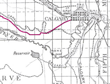
This interim report was followed by a preliminary major roads plan that was presented to City Council in the winter of 1952. The plan contained many of the same routes as the earlier General Plan interim report, though the southwest bypass was now envisioned along 24th street SW/Crowchild Trail, rather that 14th street SW, as the north-south portion of the route.3

1952-road-highlight

(A depiction of Calgary’s Major Roads Plan as presented to City Council. Source: Traffic Problem Solution Seen. Nigel Dunn. Calgary Herald. December 19, 1952. Highlight added.)

Although these initial planning efforts focused on routes contained within the City’s limits, plans were simultaneously being prepared on a wider scale; the City’s major road plan was not intended as a final document, but was intended to be continually updated and expanded as conditions demanded.

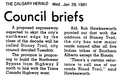
The City’s planning department had earlier drafted a different map in 1952 that for the first time described the series of planned bypass roads as a ‘Ring Road System’, and indicates, though does not fully depict, a southwest bypass located on 37th street SW.4 This was an internal working document that was not intended for the public, and shows how the City had begun to look outside of it’s city limits at more regional roads.

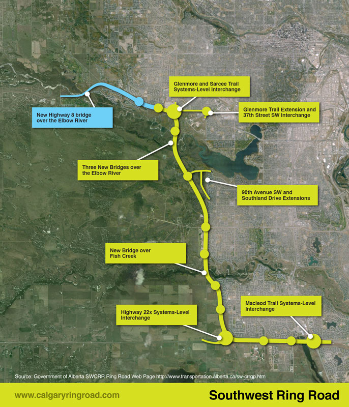
In late 1953 a further revision was completed, which for the first time fully detailed a Southwest Ring Road route around the west edge of the Glenmore reservoir.Comprising of 90th avenue SW on the south and 53rd street SW/Sarcee Trail on the west, this version of the Southwest Ring Road shares little in common with the modern route, though the use of the Sarcee Trail right-of-way and a crossing through the Weaselhead would remain part of the Southwest Ring Road plans for decades to follow.

1953-highlight

(Source: Untitled Map. December 1953. City of Calgary Corporate Records, Archives. Board of Commissioners S. IV box 189 F. 39.)

By the early 1950s the City had a defined, though extremely fluid, ring road plan. Work on the plan by the City of Calgary would continue for a number of years yet, though putting the scheme into action could not be done by the City alone; implementation would require a partner in the form of the Provincial government.

Continue reading “The Origins of the Southwest Ring Road”

The Southwest Ring Road: 60 Years in the Making

Today, the City of Calgary’s Transportation Department will present to the Transportation and Transit Committee on issues related to the yet-to-be-constructed West and Southwest Ring Road projects. As it happens, today also marks an important date in the history of the ring road. It was exactly 60 years ago that the Province of Alberta first announced plans for what would eventually become the Southwest Calgary Ring Road.

On Friday, November 18, 1955, the Calgary Chamber of Commerce held a meeting at the Palliser Hotel in downtown Calgary. Speaking at the event was Social Credit MLA and Minister of Highways Gordon Taylor, who provided a summary of the Province’s 12-month plan for highway projects in the Calgary area.

na-5600-7844a

(The Hon. Gordon Taylor, Minister of Highways (Centre) shown here opening the Mewata Bridge, Calgary, 1954. Glenbow Archives NA-5600-7844a)

Continue reading “The Southwest Ring Road: 60 Years in the Making”

Federal Funding Announcement

On Thursday July 30 2015, Federal Minister for National Defence and Multiculturalism Jason Kenney, along with Alberta Minister for Transportation Brian Mason, announced Federal funding for the Southwest Calgary Ring Road project.

At the announcement, also attended by Tsuut’ina Chief Roy Whitney-Onespot, Kenney detailed a commitment of $582.9 million, which represents one quarter of the estimated $2.8 billion cost for construction of this leg of the road. The funds are being earmarked from the National Infrastructure Component of the New Building Canada Fund, which ‘provides funding for projects of national significance’1.

July_2015_update_new

(Map showing the newly revised route of the Southwest ring road; from Macleod trail in the south, to west of 101st street SW in the west.)

Continue reading “Federal Funding Announcement”

Highway 8 and the Ring Road

This month, the Government of Alberta revised the plans for the Southwest Calgary Ring Road Project by extending the western portion of the road into the Highway 8 corridor. This section of the ring road, what is currently Highway 8 from Sarcee trail to just west of the Calgary city limits and highlighted below in blue, had until recently been a part of the West Calgary Ring Road Project. This change shifts approximately 5km of roadway to the Southwest ring road, adds one additional interchange (69th street SW) and a new crossing over the Elbow River to the project, while removing the same from the West leg of the road.1

July_2015_update_new(The previous Southwest ring road route in green, with the addition of a portion of Highway 8 in blue, making up the most recent Southwest ring road alignment.2)

This section of Highway 8, between Sarcee trail and 101st street, has played an important role in the history of the ring road, not only recently, but for many years before.

South Morley Trail, Springbank Trail, Richmond Road and Highway 8

The modern Highway 8 partially follows the route of one of the oldest roads on Calgary’s west side. Richmond road, first known as South Morley Trail, was a key trail west of the city in the 19th century, and originally connected Calgary to the Stoney Nakoda First Nation Reserve via Springbank.3

1894_Richmond_Road(The Richmond road corridor highlighted in pink, 1894.3)
Continue reading “Highway 8 and the Ring Road”

Budget 2015 and the Ring Road

Yesterday the Alberta government announced details of the proposed budget for 2015, which includes information about the two remaining portions of the Calgary Ring Road. As a cost-cutting measure, the West Calgary Ring Road is being delayed by four years, and construction is now slated to begin in 2020/2021. Expected completion of this leg, and ultimately the entire ring road, will not occur until 2024/2025, and the measure is expected to defer a reported $1.5 billion from the current budget time-frame. W&SW_Ring_Road The Southwest Calgary Ring Road, the portion that runs through the Tsuut’ina Nation reserve, remains unaffected. Work will begin on this leg of the road once the Tsuut’ina land transfer has been approved and once a contract has been tendered and awarded, with construction expected to begin next year. The agreement signed between the Nation and the Province in 2013 commits the Province to open the Southwest portion of the road within 7 years of the land transfer, and the opening is estimated to occur in 2020. The 2015 budget allocates $2.9 billion over the next 5 years towards the construction of Alberta’s ring roads. This figure includes funds needed to complete Edmonton’s Anthony Henday Drive as well as beginning work on the Southwest Calgary Ring Road (interestingly referred to as ‘Southwest Stoney Trail’ in the Province’s 5-year Capital Plan despite a promised name change as the road crosses through former Tsuut’ina reserve lands).