
On May 1 2015 the Privy Council of Canada passed order 2015-0556, which authorizes the transfer of the proposed Southwest Ring Road corridor to the Province of Alberta. The same day, the Council passed a separate order, 2015-0557, which adds and incorporates former Alberta Crown lands into the Tsuut’ina reserve. With these two documents the land acquisition required for the Southwest Calgary Ring Road is approved.
The Province transferred $275,000,000 to the federal government in April of this year. The payment for the land will only be forwarded to the Tsuut’ina Nation, and the land title will only be assigned to the Province, once the Federal Minister of Aboriginal Affairs and Northern Development Canada signs off on the transfer.

(Source: Canada Lands Survey Records (CLSR) 103661 January 21, 2015 and CLSR 103574-1 December 17, 2014. Image: Google Maps)
The Image above shows the new boundaries of the Tsuut’ina reserve. The original reserve (created in 1883) is shown in blue, while the newly added land (2015) is shown in magenta. The Weaselhead (1931), the Highway 22 corridor (1957) and the Southwest Ring Road corridor (2015) have been removed from the original reserve.
Moving Forward
The 2013 referendum of Tsuut’ina members, and the subsequent ratification of the agreement, meant that the Nation approved the sale and exchange of lands in order for the Province to acquire the corridor needed to build the Southwest Calgary Ring Road. Over the past 18 months, both the Province and the Nation have worked to fulfill their obligations under the agreement, in order to ensure that the land transfers would be approved by the Federal Government. Once the transfer has been enacted, which provincial representatives expect soon, the Province will have seven years in which to construct the road.
The commitment to construct the road was recently reaffirmed by former Premier Jim Prentice in the Progressive Conservative’s 2015 Provincial Budget, with construction of this leg of the ring road planned to begin as early as 2016. Though a new government is now in place, a finalized transfer of the corridor will oblige the Province to construct the road as agreed, or face the loss of the land and the money already paid.
Premier-designate Rachel Notley did not take a definitive stance on the Calgary Ring Road in the course of the 2015 election campaign, though she is quoted in relation to the ring road project as saying “In principle we are adopting the capital funding envelope and the vast majority of the commitments that the [Progressive] Conservatives have already adopted so you’d see us being in line with what’s already in the budget.” (Calgary Herald, April 29 2015, ‘Wildrose Leader Brian Jean promises to finish Calgary ring road by 2021′)
Earlier in January, Notley is also quoted as saying “If you do move ahead with infrastructure when the economy slows, you can do it less expensively… You may take on debt in the short term but you will be able to construct at a time when costs are low… Projects should be continued, not abandoned.” (Calgary Herald, January 14 2015, ‘Southwest ring road construction up in the air’).
Changing Boundaries
Despite the removal of over 1000 acres of land, the Tsuut’ina will see a net increase in the size of the reserve. Smaller land sales throughout the years has slowly eroded the overall land base of the Nation, and the new addition means that for the first time since the reserve was established in 1883 the total area will exceed the original allocation of approximately 69,000 acres.
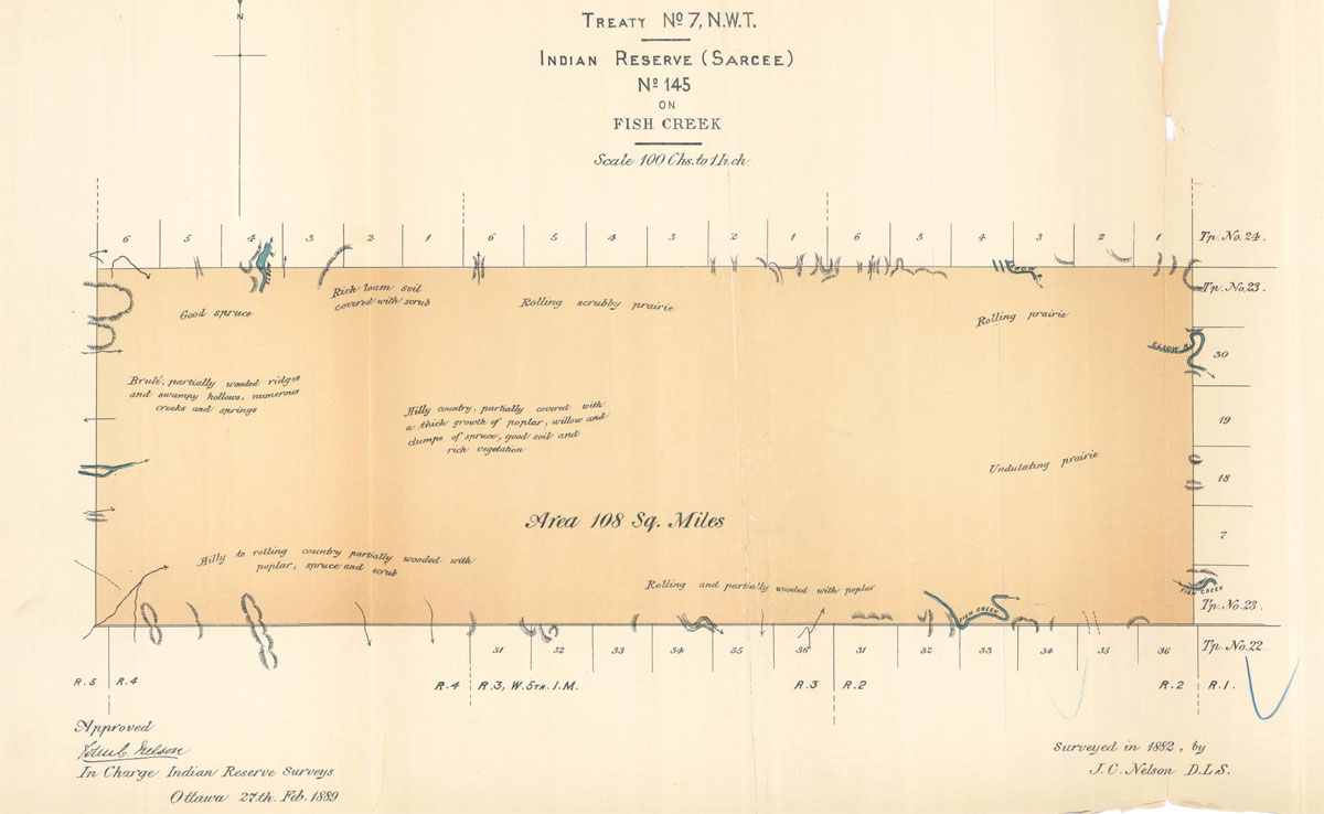 (Tsuut’ina reserve, surveyed 1882. Image: Descriptions and Plans of Certain Indian Reserves in the Province of Manitoba and the North-West Territories, 1889. Nelson.)
Subtractions
The corridor for the Southwest Ring Road comprises a total of 1058 acres (428.167ha), and runs along or near almost the entire eastern border of the Tsuut’ina reserve. The Province will retain the land for as long as it is being used for the Southwest Calgary Ring Road, though should the Province fail to construct the road, or if it decides in the future to close the road, the 2013 agreement stipulates that the ownership of the corridor would revert back to the Nation and would be reintegrated into the Tsuut’ina reserve.
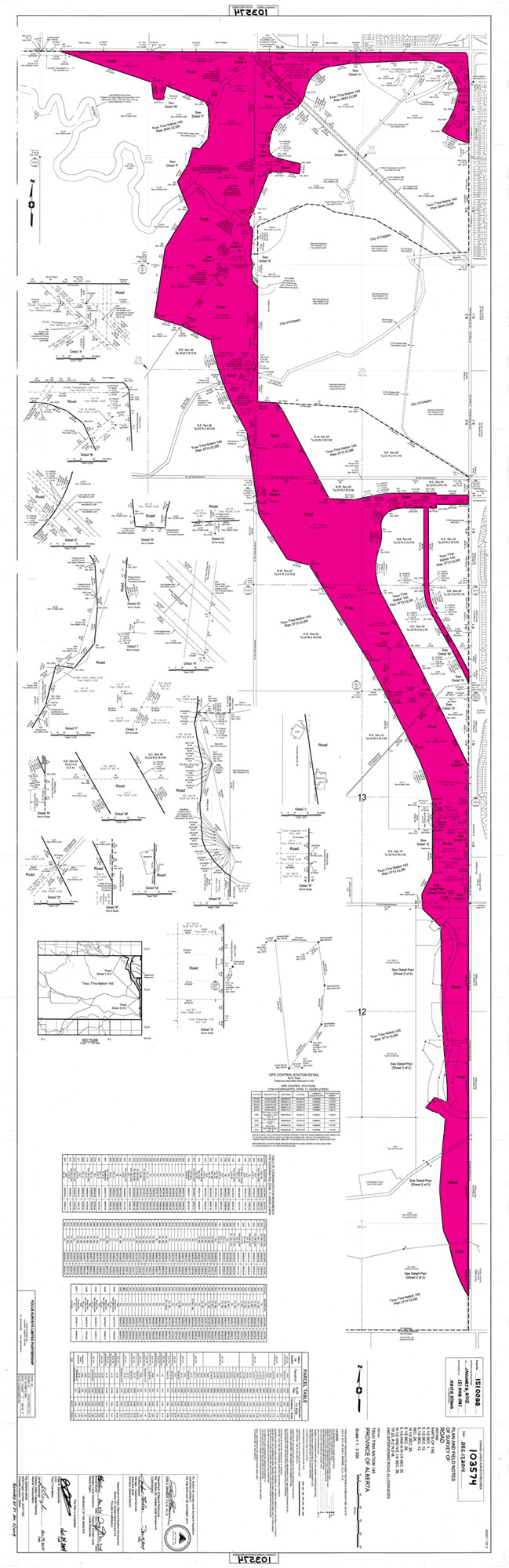
(Image: CLSR 103574-1 December 17, 2014. Coloured by the author)
Additions
The new land that has now been added to the Tsuut’ina reserve totals 5338.16 acres (2160.275ha). This includes a 320 acre portion (shown in blue below) that was purchased by the Nation for $1,643,200, which is in addition to the 5018.16 acres provided in exchange for the Southwest Ring Road corridor. While most of the land includes mineral rights, a 319.58 acre portion has been exchanged without mineral rights (shown in yellow below). All government road allowances that crossed the new addition have been closed and are included in the transfer.
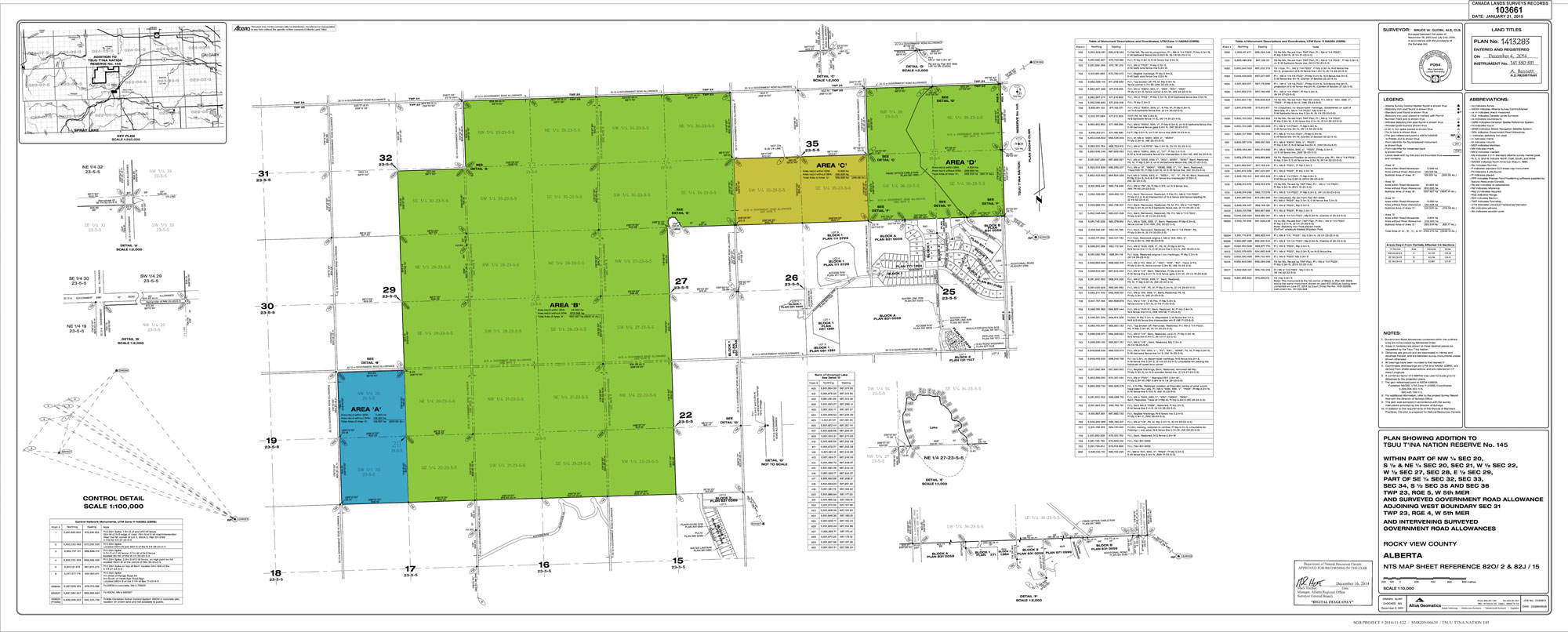
(Image: CLSR 103661 January 21, 2015. Coloured by the author according to Final Agreement 2013, Schedule 1: Additional Lands, Tsuut’ina Nation and Province of Alberta)
Next steps
With the land transfer approved, the road is on its way to becoming a reality. The next steps for the Province, once the land transfer has been completed, are to tender and award the construction contract in order to fulfill the seven-year commitment to build and open the road.
—–
EDITED 5:39pm Friday May 15, to clarify that the seven-year timeframe in which to build the road will not begin until the Minister of Aboriginal Affairs and Northern Development Canada finalizes the land transfer of the road corridor to the Province.
—–
Sources:
• Order in Council of the Privy Council of Canada 2015-0556, May 1 2015. Government of Canada.
• Order in Council of the Privy Council of Canada 2015-0557, May 1 2015. Government of Canada.
• “Final Agreement” between the Tsuut’ina Nation and the Province of Alberta. November 27 2013.
• “Plan and Field Notes of Survey of Road within Parts of the E.½ Sec. 1, E.½ Sec. 12, E½ Sec. 13, Sec. 24, W.½ Sec. 25, E.½ Sec. 26, E.½ and N.W.¼ Sec. 35, W.½ and N.E.¼ Sec. 36, TP. 23, R.2 W.5M. and Intervening Road Allowances within Tsuut’ina Nation 145 Province of Alberta” (103574 CLSR). Iain A. Skinner, C.L.S., A.L.S., Recorded in Ottawa December 17 2014.
• “Plan Showing Addition to Tsuut’ina Nation Reserve No. 145 within part of
NW¼ Sec 20, S½ & NE¼ Sec 20, Sec 21, W½ Sec 22, W½ Sec 27, Sec 28, E½ Sec 29, Part of SE¼ Sec 32, Sec 33, Sec 34, S½ Sec 35 and Sec 36 Twp 23, Rge 5,
W 5th Mer and Surveyed Government Road Allowance Adjoining West Boundary Sec 31 Twp 23, Rge 4, W 5th Mer and Intervening Surveyed Government Road Allowances Rocky View County Alberta” (103661 CLSR). Bruce W. Gudim. Recorded in Ottawa, January 21 2015.
• “Descriptions and Plans of Certain Indian Reserves in the Province of Manitoba and the North-West Territories”. Nelson. 1889.
• “Survey of Indian Reservation FOR The Sarcees (Chief Bull’s Head) AT Fish Creek” (308 CLSR). Nelson. Recorded in Ottawa November 2 1883.
