
This article is the second in a series looking at the history of the crossing of the Elbow river near the Weaselhead. Part 1: 1956 to 1986 can be found here, and parts 3 and 4 will follow.
In the 1970s and 1980s, planning for the Southwest Calgary Ring Road, also known as the Sarcee Trail south extension, was characterized by practical considerations such as route location, land acquisition and functional planning. The period of the 1990s by contrast would be marked by something of a step-back from applied planning, and would include a serious re-examining of priorities.
The continued dominance of the automobile and the crossing of Calgary’s rivers by a network of freeways has often been seen as inevitable. This view, however, would be challenged by a renewed expression of concern over the impacts this situation would have on parks, communities and natural areas.
A New Transportation Bylaw for Calgary
In May of 1990 the City of Calgary released a preliminary look at a proposed bylaw that sought to affirm the city’s future transportation needs. In addition to public transit, bylaw 29M90 also detailed Calgary’s existing road network and plans for future expressways and freeways throughout the city. The plan was composed largely of elements from previous planning efforts, and included a map that showed proposed roads that had long been a part of City plans, including some that dated back to the early 1950s. The bylaw also contained a number of previously proposed, but as-yet unbuilt river crossings, including the southern extension of Sarcee Trail across the Elbow river. It is these crossings that would spark Calgary’s largest public consultation efforts undertaken to that point[1].

(Source: Calgary bylaw 29M90. City of Calgary, 1990)
The bylaw included the following new river crossings (also shown above):
1. Stoney Trail NW over the Bow river
2. Sarcee Trail north extension over the Bow river
3. Shaganappi Trail south extension over the Bow river
4. South Downtown Bypass over the Elbow river
5. 50th Avenue South over the Elbow river
6. Sarcee Trail south extension over the Elbow river
Public reaction to the proposed bylaw was swift and largely unfavourable, with citizen groups particularly denouncing the negative impact that new river crossings would have on parkland, river valleys, natural areas and local communities[2]. Within a month of the bylaw’s unveiling, several hundred citizens had attended a City Council meeting on the topic, and many more contacted Aldermen, signed petitions and formed action groups to oppose the plan and to call for the process to be opened up to public consultation.
Although the bylaw was approved by Council in July 1990, the response from the public spurred the City to begin a multi-year, multi-million dollar consultation and review of the road network and future transportation needs the very next year. This process was called the GoPlan.
(Source: Calgary Transportation Plan. City of Calgary, 1995)
The GoPlan and River Crossings
Consultation for the Calgary Transportation Plan, or GoPlan, began with preliminary meetings in late 1991, and solicited the views of citizens with open houses, workshops and surveys over the following few years. By early 1994, several potential scenarios for Calgary’s future transportation network were crafted by the GoPlan working group, and were presented to the public for feedback.
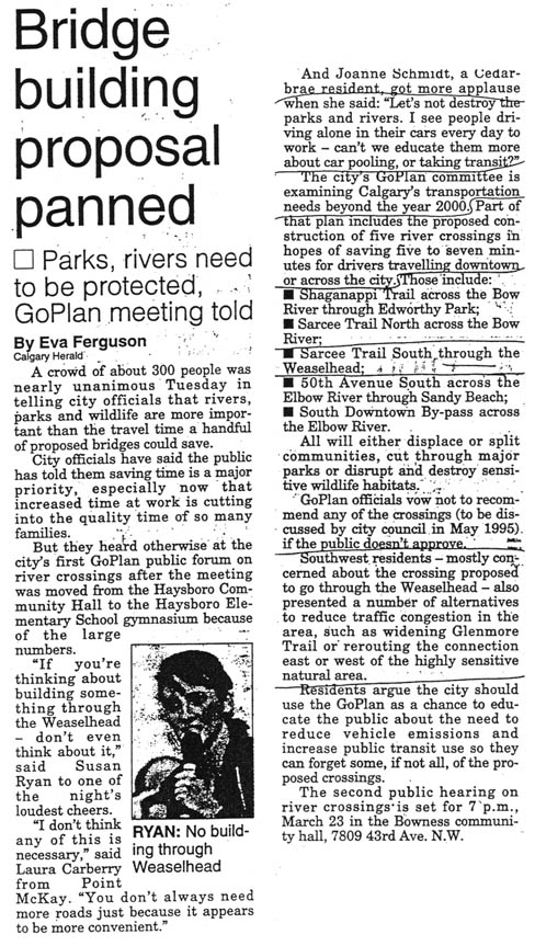
(Calgary Herald March 16 1994)
The four newly-proposed scenarios contained many of the contentious river crossings that had led to the creation of the GoPlan process in the first place, and all included the Elbow river crossing of the Sarcee Trail. The concern over the impacts of these crossings led to the creation of environmental groups dedicated to protecting city parks; among them was the Weaselhead/Glenmore Park Preservation Society which formed as a direct result of the GoPlan proposals, and the Edworthy Park Heritage Society, previously formed at the outset of the bylaw 29M90 discussions. Even Premier Ralph Klein reportedly entered the debate over new river crossings by writing to a constituent and indicating his opposition to a Sarcee Trail south extension that bisected the Weaselhead[3].
These groups, in conjunction with the River Valleys Committee, called for the City to consider a scenario with no new river crossings; to focus instead on improving the efficiency of existing roads and improving public transit. In order to avoid pitting ‘community versus community’, the River Valley Committee (now known as Calgary River Valleys) helped coordinate efforts between groups to ensure a unified voice against new crossings.
“Each proposed crossing had a group of people who were opposed to the crossing in their own area. River Valleys Committee (RVC), chaired by John Simonot at the time, encouraged the various groups to support each other in their defence of their section of river. That strengthened each group, and kept the communities from being pitted against each other.” -Susan Ryan[4]
The GoPlan working group had stated that any crossings not approved by the public would not be recommended for inclusion in the final plan[5], and by May of 1994 the plans included for the first time an option with no new river crossings at all.[6]

(The Elbow river valley at the Weaselhead. Author’s own photo, 2014)
The public discussion around new river crossings, so far dominated by the GoPlan working group and concerned citizens, would receive another perspective in the form of a study commissioned by the GoPlan working group itself. IMC Consulting Group Inc. was hired to look at the merits of new river crossings as compared with ‘no-new-crossing’ alternatives for several of the proposed roads. The draft of the study reportedly showed that new river crossings of Sarcee Trail (both north and south) were significantly more expensive than upgrading existing routes, and would have a “high” level of impact on local parkland and environmentally sensitive areas. The report went on to note that the new crossings would provide greater capacity and flexibility than would be provided by expanding existing routes, but that “[t]he river crossing option provides very small mobility benefits in terms of travel time savings for trips to and from areas primarily on the west side of the city.”[7] Contemporary media reports characterized new river crossings as being ill-advised, and of having only marginal value given the higher cost and greater impacts to the city.
The conclusions of this report, along with continued input from the public, politicians, city planners and consultants, ensured that the plan would continue to evolve, and a final version of the GoPlan would eventually be adopted by Calgary City Council in 1995.
GoPlan is a Go
In contrast to most earlier drafts, the final version of the Calgary Transportation Plan now contained no new river crossing within the plan’s 30-year timeframe.
In addition to calling for the maximizing of the efficiency and capacity of existing routes, the report contained guidance on changes that would move the city away from a reliance on automobiles; this included land-use recommendations that encouraged more compact, walkable neighbourhoods, as well as further investment and improvement to public transit. All of the study’s recommendations taken together was enough to ensure that new river crossings would not be recommended in the City’s near future. “…changes to land use planning and travel behaviour trends could help avoid the need for new bridges at the 1.25 million population mark.”[8]
As a way to ensure future flexibility and capacity, only one new roadway river crossing was recommended for protection; the Sarcee Trail south extension across the Elbow river was to be considered for construction only beyond the 30-year timeframe of the GoPlan. This link was not envisioned as part of the short-term skeletal road network, but instead it was recommended that the right-of-way be acquired and reserved in order to handle future growth on the city’s Southwest edges.
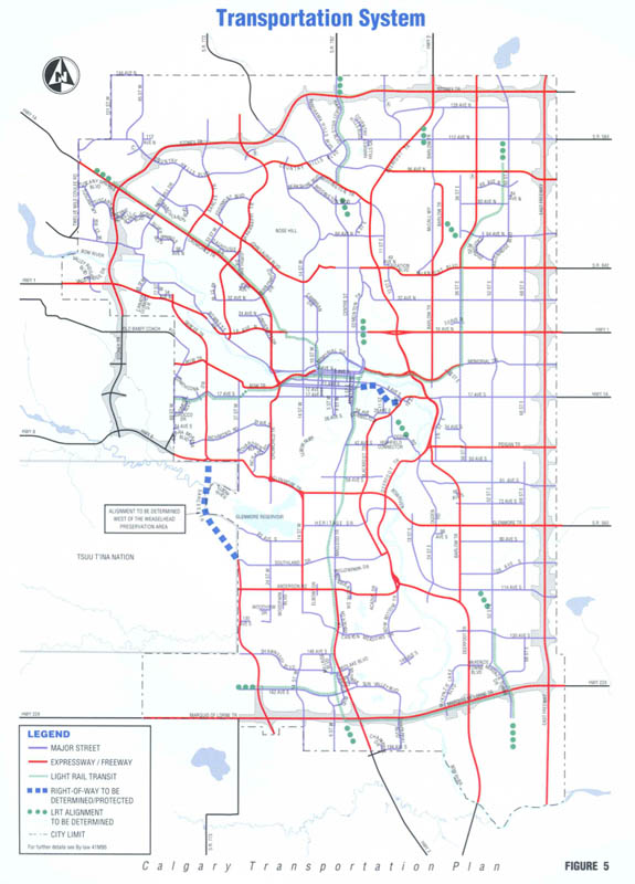
(Calgary Transportation Plan. City of Calgary, 1995)
In an acknowledgement of environmental concerns, the recommended alignment for this road was west of the Weaselhead within the Tsuut’ina reserve, although the exact location and the specific design for the crossing were not addressed at this time. The plan went on to note that an extension of 37th street through Lakeview (and thus over the Glenmore reservoir or through the Weaselhead) should not be considered as part of a Sarcee Trail south extension.
Moving Forward
The City’s decision to recommend an alignment for the Sarcee Trail south extension within the Tsuut’ina reserve, was done to “… [avoid] environmentally sensitive land in that area as much as possible and community impacts, particularly in the Lakeview district”[9]. This location would avoid the most direct impacts to Calgary parkland and communities (though of course not to Tsuut’ina land or residents), but it would also ensure a greater uncertainty over the ability to construct the road at all. By recommending an alignment located in a jurisdiction outside of their control, the City was relying on successful negotiation with the Tsuut’ina to ensure that the road could be built.
This uncertainty combined with a lack of progress made in negotiations over the following years meant that alternative alignments, once thought unacceptable, would again be considered. Despite four years and $4 million spent on the process[10], the continuing pressure to build the Southwest Calgary Ring Road would ensure that the GoPlan would not be the final word in the crossing of the Elbow river.
In part three we will look at alternative plans for the crossing of the Elbow river that were considered for the Southwest Calgary Ring Road between 1994 and 2003.
Thank you to Susan Ryan, Bill Morrison and Eric MacNaughton.
[1] “In Our City” Calgary Herald, 10 August 1995
[2] Calgary Transportation Plan. City of Calgary, 1995
[3] “Klein opposes Weaselhead road plan” Calgary Herald,1 December 1994
[4] Susan Ryan, former board member of River Valleys Committee/Calgary River Valleys and current board member of Weaselhead/Glenmore Park Preservation Society. Personal correspondence, 30 December 2014
[5] “Bridge building proposal panned” Calgary Herald, 16 March 1994
[6] By 1994, the Stoney Trail NW crossing of the Bow river had already been approved by the City, and although still unconstructed, was excluded from the GoPlan consultation process.
[7] “River crossings opposed” Calgary Herald, 22 November 1994
[8] Calgary Transportation Plan. City of Calgary, 1995
[9] Calgary Transportation Plan. City of Calgary, 1995
[10] “GoPlan hit from start by critics” Calgary Herald, 4 February 1995
