Finding Weaselhead


The Weaselhead Flats park is a 593.5 acre area of the Elbow River valley upstream of the Glenmore Reservoir in Southwest Calgary. The first recorded mention of the name ‘Weaselhead’ in relation to the Elbow river valley dates back to the 1890s, but where did the name originate? Why do we call this park, and the rest of the valley within the Tsuut’ina Nation reserve, ‘Weaselhead’?

IMG_6190

There are a number of explanations for the origin of the Weaselhead name, and while some details may never fully be known, we can begin to learn the story of where the name came from, and how the area came to be known as the Weaselhead. 

Conflicting Origin Stories

The City of Calgary acknowledges that the origin of the name of the Weaselhead Flats park is unclear, but points to the idea that the area was named after a Tsuut’ina man named Weaselhead. According to the City, the area is “…likely named after the Tsuu T’ina Chief Weaselhead who was in power at the time of European contact.”1

However, this isn’t the only origin story regarding the Weaselhead name; there is an alternative explanation known within the Tsuut’ina Nation which proposes just the opposite. In this version, Weaselhead was not Tsuut’ina, but a con-man from another Nation who was murdered along the banks of the Elbow river when his criminal ways caught up with him. According to this retelling, the name Weaselhead was then given to the area as a cautionary tale against adopting such a lifestyle.2

Clearly both cannot be true, and there is enough evidence that would suggest that perhaps neither is exactly right. Both stories say that Weaselhead was a man, but what do we know about this man, and how did he come to lend his name to this part of the Elbow River? Continue reading “Finding Weaselhead”

Jane’s Walk 2019: The History of the SW Ring Road and the Weaselhead

Why was the SW ring road planned through a First Nation’s reserve? How did the Weaselhead come to be owned by the City of Calgary? Why are Unexploded Ordnance being found in the Elbow river valley?

Join me again on this year’s Jane’s Walk through a beautiful and historic part of Calgary.

This is the fifth year that I will be leading the walk, and it will be a chance to talk about many of the issues I have covred on this blog; to look at the history of the SW Ring Road and to explore the past, present, and future of the Weaselhead area, one of the most historically rich parts of Calgary.

We’ll travel along the first Provincial highway that was built through the Tsuut’ina Nation reserve over 115 years ago (with origins dating back even before the signing of Treaty 7) and through land that was purchased in the 1930s for the Glenmore Reservoir. We’ll see where the Canadian Military operated the largest WWI training camp in Western Canada, and explore the legacy of disputed land ownership and unexploded ordnance that years of military use has left behind. We’ll experience one of the quietest corners of the city, now adjacent to where the SW Ring Road is being built, and see where previous plans would have located the road through the valley.  We’ll look at the role that the Tsuut’ina Nation’s economic development plans have played in getting the road approved, and how Calgary and the Nation can come together as development progresses.

Details

Date: Sunday May 5, 2019
Time: 1:00 pm
Duration: about 2.5 hours
Meeting Place: North Weaselhead Parking Lot (at the corner of 37th street SW and 66th avenue SW in Lakeview)

Don’t forget to download the handout to your smartphone for the walk! Download here


Jane’s Walk in Calgary

Click here to visit the Jane’s Walk description for the SW Ring Road and Weaselhead walk

Thank you to Stephanie Hawes for providing the photos of the 2017 walk!

Jane’s Walk 2017


Jane's Walk graphic photo 2017 A

Why was the SW ring road planned through a First Nations reserve? How did the Weaselhead come to be owned by the City of Calgary? Why are Unexploded Ordnance being found in the Elbow river valley?

Join me on this year’s Jane’s Walk through a beautiful and historic part of Calgary, and learn about the soon-to-be-built SW ring road, 60+ years in the making.

weaselhead

The turn out for the last year’s walk was fantastic, and I will be leading it again for the third time this year. The walk will be a chance to talk, to look at the history of the SW Ring Road, and to explore the past, present, and future of the Weaselhead; one of the most historically rich areas of Calgary.

We’ll travel along the first Provincial highway that was built through the Tsuut’ina Nation reserve over 115 years ago (with origins dating back even before the signing of Treaty 7) and through land that was purchased in the 1930s for the Glenmore Reservoir. We’ll see where the Canadian Military operated the largest WWI training camp in Western Canada, and explore the legacy of disputed land ownership and unexploded ordnance that years of military use has left behind. We’ll experience one of the quietest corners of the city adjacent to where the SW Ring Road is planned to be built, see where previous plans would have located the road through the valley, and look at the role that future economic development has played getting the road approved.

Details

Date: Sunday May 7, 2017
Time: 1:00 pm
Duration: about 2 hours
Meeting Place: North Weaselhead Parking Lot (at the corner of 37th street SW and 66th avenue SW in Lakeview)


Jane’s Walk in Calgary

Click here to visit the Jane’s Walk description for the SW Ring Road and Weaselhead walk
and
Click here to see all of the Jane’s Walks that will be happening this year


With thanks to Doug Sephton for the photos of last year’s walk.

The Rise and Fall of the Priddis Trail – Part 3: Closure

This is the third in a five-part series looking at the history of the Priddis Trail. The first part, which examined the establishment of the road can be found here. while part two, focusing on the early years of the road is here. I acknowledge that the resources that inform this work are largely that of non-First Nations sources, and in particular this article will focus on a non-indigenous perspective on the decline of the Priddis Trail. The next article will look more at the Military’s use of the Priddis Trail, while the final part looks at the problematic legacy of this road, and will begin to address the perspective not covered in this section.


Three decades after beginning life as a Government highway, the Priddis Trail was in 1930 a well-used main road that served a growing agricultural district, a burgeoning oil industry, a First Nation and an important Military training camp.

The establishment in 1900 of the road, built along the route of an old trail that crossed the Tsuut’ina Nation reserve, was originally done in order to provide reliable access to lands located southwest of Calgary. The original trail between the city and the Priddis area was notorious for its chronically poor, often impassable condition, and it was expected that upon acquiring the corridor for the road from the Tsuut’ina Nation, the Government would create and maintain a modern and reliable road. It was this desire for better access that led homesteaders to petition the government to acquire the road in the first place, and yet three decades later, this objective remained largely unfulfilled; although a road had certainly been built, it was proving far from suitable.

1926-pt(The route of the Priddis Trail (magenta) between Calgary and Millarville through the Tsuut’ina Reserve (outlined in light-pink). Source: Topographical Survey of Canada, Department of the Interior. Calgary District, Alberta. Ottawa: Department of the Interior, 1926. Peel’s Prairie Provinces Archives, University of Alberta. Map 17. Highlight added.)

The new road suffered from the same wet, periodically impassible conditions that plagued the original wagon trail. The condition of the road was exacerbated in the 1920s` by an influx of traffic brought on by an oil boom in the Turner Valley, which the Priddis Trail increasingly served. In 1930 the Province of Alberta recognized that improving the road with proper drainage and a gravelled surface would benefit both residents and industry alike, and secured funding to improve and reconstruct the road in order to make the Priddis Trail into what would soon be known as Highway 22. Continue reading “The Rise and Fall of the Priddis Trail – Part 3: Closure”

Jane’s Walk 2016 – Sunday May 8

Jane's Walk graphic photo 2016 small

THE HISTORY OF THE SW RING ROAD AND THE WEASELHEAD WALK

Why was the SW ring road planned through a First Nations reserve? How did the Weaselhead come to be owned by the City of Calgary? Why are Unexploded Ordnance being found in the Elbow river valley?

Join me again on this year’s Jane’s Walk through a beautiful and historic part of Calgary, and learn about the soon-to-be-built SW ring road, 60+ years in the making.

Weaselhead Janes Walk wide

The turn-out for last year’s walk was fantastic, and I will be leading it again this year. The walk will be a look at the history of the SW Ring Road, and will give anyone who is interested the chance to explore the past, present, and future of the Weaselhead; one of the most historically rich areas of Calgary.

Travel along the first Provincial highway that was built through the Tsuut’ina Nation reserve over 115 years ago (with origins dating back even before the signing of Treaty 7) and through land that was purchased in the 1930s for the Glenmore Reservoir. See where the Canadian Military operated the largest WWI training camp in Western Canada, and explore the legacy of disputed land ownership and unexploded ordnance that years of military use has left behind. Experience one of the quietest corners of the city adjacent to where the SW Ring Road is planned to be built, see where previous plans would have located the road over the valley, and look at the role that future economic development played getting the road approved. Continue reading “Jane’s Walk 2016 – Sunday May 8”

The Rise and Fall of the Priddis Trail – Part 2: A Road In Use

This is the second in a five-part series looking at the history of the Priddis Trail. The first part, which examined the establishment of the road can be found here, and part three can be found here. I acknowledge that the resources that inform this work are largely that of non-First Nations sources, and while this is intended to be a factual look at the history of the road, it must be noted that the perspective is largely non-indigenous. I hope that further research and working with Tsuut’ina sources will reveal other equally valid perspectives on this story in the future.

—–

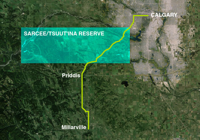
From Governor-Generals, Tsuut’ina Chiefs and Colonels, to Ranchers, Homesteaders and Boy Scouts, the Priddis Trail was important to a great many people for a great number of reasons. The establishment of the Tsuut’ina reserve and an early influx of Homesteaders in the late 1800s, followed not long after by the Military and a growing oil industry, meant that reliable access to a growing district was vital to the region.

map-pt-only(Map of the route between Calgary and Millarville through the Tsuut’ina Reserve in 1899. Source: ‘Plan Shewing survey of Old Trail and New Road from N.E. Cor. Sarcee Indian Reserve to Millarville P.O.’ A. P. Patrick. 1899. Plan 1119i, Alberta Land Titles, Southern Alberta Land Registration District )

BEFORE THE HIGHWAY, A TRAIL

When first formed, the route that would become the Priddis Trail was a modest dirt track used by members of the Tsuut’ina Nation and by Homesteaders living in the Priddis and Millarville districts of Alberta. Suitable for horse-and-wagon travel, the trail provided a much needed connection between these southern areas and Fort Calgary, including the burgeoning town that had begun to grow around it. In its earliest days, the land that the trail passed through had not yet been designated as the Tsuut’ina reserve1, and when the reserve was established in 1883, the use of the trail continued unabated by Tsuut’ina members and non-Indigenous settlers alike.

pa-3516-7
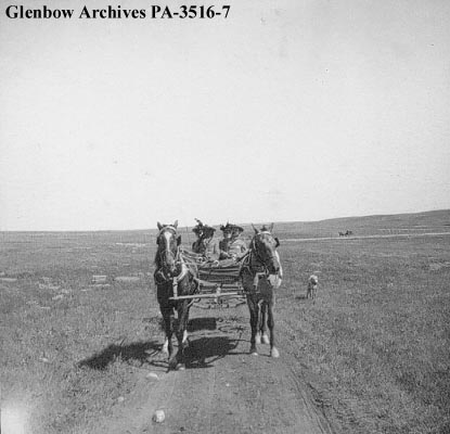
(‘Group of visitors in wagon on the way to Sarcee (Tsuu T’ina) reserve, Alberta.’ Glenbow Archives PA-3516-7. ca. 1899)

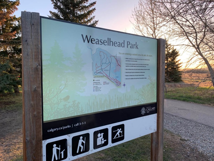
The earliest record of the Priddis Trail comes not from the path itself, but of the trail’s crossing of the Elbow river, known as the ‘Weasel Head Crossing’. In December of 1890 a newspaper article noted the Weasel Head Crossing as the site of the butchering of stolen cattle,2 making this the first mention, albeit indirectly, of both the trail and of the ‘Weaselhead’ name that this part of the Elbow river valley would later become known by.

By 1894 the first map of the route was made by the Department of the Interior3, and soon the trail was showing up regularly in newspaper accounts and official documents. In response to questions about the trail in 1899, the acting Agent of the Sarcee Agency stated: “(Chief Bull Head) informed me the trail marked in the plan was in use by the Indians before the treaty was made with them.”4, an indication of the long use of this important connection.

PriddisTrail_1897(A map from 1897 [with added highlights] showing the route of the Priddis Trail. Source: “Preliminary map of a portion of the District of Alberta showing Canadian irrigation surveys during 1894″. University of Alberta Libraries, Peel Map 747.)

For users of the road, whether Nation members or Homesteaders, the trail enabled sustainability and economic activity by providing access to the marketplaces of Calgary. In 1893, for instance, a “comfortable dwelling house, with a good stable and corral” was built at the Weasel Head Crossing so that Tsuut’ina members had a place to stay when harvesting timber destined for sale in the City5. Former Tsuut’ina Nation Chief Sanford Big Plume also noted the use of the old trail in the Nation’s economic and cultural activities: “In the late 1800s… Once a year, Foxtail would cut small evergreens, load them on a wagon led by horses, and drive them down the Priddis Trail to Fort Calgary. There, they were sold as Christmas trees. With the proceeds of those trees, Foxtail would help fund a meal for our people, so we could also celebrate Christmas.”6

In a similar way, Homesteaders relied on the trail to bring produce and stock to market, and to access the services that the City offered.

pa-1004-18
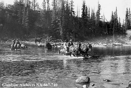
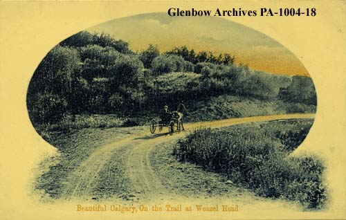
(Postcard showing a wagon on the Priddis Trail. ‘Weaselhead district, Calgary, Alberta.’ Glenbow Archive PA-1004-18. ca. 1908.)

Besides being functional, the trail was also noted to offer access to some of the more beautiful country in the area, and the use of the trail for pleasure would increase in popularity over the years. In the summer of 1895 the Governor-General of Canada Lord Aberdeen was touring the country, and by the summer of that year he had arrived in Calgary. On a morning in August, Lord and Lady Aberdeen were driven in the vice-regal carriage to a meeting with members of the Tsuut’ina Nation via the trail; the journey having been noted in the Calgary Daily Herald as “one of the prettiest drives in the N.W.T.”7. Forty years later, noted homesteader A.M. Stewart mirrored that sentiment in stating “…this road constitutes about the prettiest drive out of Calgary.”8 and the route was included in maps of automobile pleasure tours for the Calgary region.9

The still-nameless trail was increasingly well-used, and this usage would soon outstrip the ability of the trail to comfortably accommodate the traffic. By the end of the 1890s, muddy conditions on the primitive trail, ruts caused by wagon wheels and a lack of a bridge over the Elbow river would cause problems for travelers looking for unimpeded access. The un-maintained dirt track was proving to no longer be suitable for the use it was expected to accommodate, and Homesteaders living in the area soon lobbied to correct the situation. Continue reading “The Rise and Fall of the Priddis Trail – Part 2: A Road In Use”

The Rise and Fall of the Priddis Trail – Part 1: Establishment

Though the Southwest Calgary Ring Road is perhaps the best known Provincial road to be planned through the Tsuut’ina Nation reserve, it is not the first; over a hundred years ago another Provincial road was sought, and built, across the Nation’s land. The story of the Priddis Trail, as the early road was known, may provide some much-needed context with which to view the long negotiations for the ring road project, and perhaps to understand how the legacy of previous land agreements may have influenced the current process.

priddis-trail-2015(Photo of a remnant portion of the Priddis Trail, 2015. Source: Author’s own.)

In this five-part series, I will look at the establishment of the old road through the Tsuut’ina reserve, the use and decline of the route as a public highway, and the problems surrounding the ownership and the handling of the land and the deal. Part two can be found here while Part three can be found here. I acknowledge that the resources that inform this work are largely that of non-First Nations sources, and while this is intended to be a factual look at the history of the road, it must be noted that the perspective is largely non-indigenous. I hope that further research, working with Tsuut’ina sources, will reveal other equally valid perspectives on this story in the future.

THE NEED FOR GOOD ROADS

At the turn of the century, settlers of the Priddis and Millarville areas of southern Alberta relied on well established, though informal and unmaintained, wagon trails in order to access Calgary and other areas and ranches of the region.

Calgary_priddis_reserve_area_new(Map of the Calgary area, showing the Tsuut’ina reserve and the Priddis area. Source: Google Maps.)

The provision of useful roads in the North West Territories was a constant battle for the Government, and many districts in the Territories, including Alberta, chronically suffered from poor or impassable routes. In 1900, the Department of Public Works noted this problem in its annual report:

“…so long as we have earth roads we must expect bad roads during wet seasons, and as the conditions in the Territories will not permit the construction of any other kinds of roads for many years to come it must be understood now that during certain years good roads will be an impossibility.” 1

In the midst of 1899, a notably wet year, local settlers and homesteaders called upon the Government of the North West Territories to improve and maintain a reliable road to the Priddis area. There already existed a well-used old trail between Priddis and Calgary, known locally as the Priddis Trail, or Gunawaspa Tina in Tsuut’ina, and it was this route that the locals wanted improved.2 Much like the case of the Southwest Calgary Ring Road, it was an alignment through the Tsuut’ina reserve that was seen by the Government as providing the most efficient route to serve those living south of central Calgary. In this case however, its use was reported to have predated the establishment of the reserve.3

PriddisTrail_1897(A map from 1897 showing the route of the Priddis Trail. Source: “Preliminary map of a portion of the District of Alberta showing Canadian irrigation surveys during 1894″. University of Alberta Libraries, Peel Map 747.)

Crossing the eastern portion of the Tsuut’ina reserve (at that time known as the Sarcee reserve) and leading diagonally from what is now the corner of Glenmore Trail and 37th street SW to a point just north of Priddis, the trail had been in use for many years by early European settlers of the area and Nation members. Like many in the North West Territories, the earthen trail suffered from regular periods of muddy and impassable conditions, and despite warnings that roads may not be improvable in the short-term, the Government had recently begun to prioritize important ‘Colonisation Roads’4 which connected newly settled areas and local market centres. Calls for the trail to be opened and improved as a public highway were heeded.

Continue reading “The Rise and Fall of the Priddis Trail – Part 1: Establishment”

Jane’s Walk – The SW Ring Road and the Weaselhead

Join me on a ‘Jane’s Walk‘ through a beautiful and historic part of Calgary, and learn about the soon-to-be-built SW ring road, 60+ years in the making.

Weaselhead Janes Walk wide

Why was the SW ring road planned through a First Nations reserve? How did the Weaselhead come to be owned by the City of Calgary? Why are Unexploded Ordnance being found in the Elbow river valley?

I will be leading a walk that will look at the history of the SW Ring Road, and give anyone who is interested the chance to explore the past, present, and future of the Weaselhead; one of the most historically rich areas of Calgary.

Travel along the first Provincial highway that was built through the Tsuut’ina Nation reserve over 100 years ago (with origins dating back even before the signing of Treaty 7) and through land that was purchased in the 1930s for the Glenmore Reservoir. See where the Canadian Military operated the largest WWI training camp in Western Canada, and explore the legacy of disputed land ownership and unexploded ordnance that years of military use has left behind. Experience one of the quietest corners of the city to see where the SW Ring Road is planned to be built, see where previous plans would have located the road, and look at the role that future economic development played getting the road approved.

Details

Date: May 3, 2015
Time: 1:00 pm
Duration: about 2 hours
Meeting Place: Weaselhead Parking Lot (West side of the corner of 37th street SW and 66th avenue SW in Lakeview)

Jane’s Walk in Calgary

Click here to visit the Jane’s Walk description for this walk
and
Cllick here to see all of the Jane’s Walks that will be happening this year (more will be added over the coming weeks)

Jane's-Walk-graphic-photo

UPDATE

I wanted to thank everyone who came to my ‘History of the SW Ring Road and the Weaselhead’ Jane’s Walk. More than 75 people came out to journey through a beautiful corner of Calgary, and were hopefully informed and entertained along the way.

I will be doing the walk again next year, so please look out for it next May!

IMG_2262 IMG_2249 IMG_2243 IMG_2237 IMG_2225

Crossing the Elbow River – 1990 to 1995

This article is the second in a series looking at the history of the crossing of the Elbow river near the Weaselhead. Part 1: 1956 to 1986 can be found here, and parts 3 and 4 will follow.


In the 1970s and 1980s, planning for the Southwest Calgary Ring Road, also known as the Sarcee Trail south extension, was characterized by practical considerations such as route location, land acquisition and functional planning. The period of the 1990s by contrast would be marked by something of a step-back from applied planning, and would include a serious re-examining of priorities.

The continued dominance of the automobile and the crossing of Calgary’s rivers by a network of freeways has often been seen as inevitable. This view, however, would be challenged by a renewed expression of concern over the impacts this situation would have on parks, communities and natural areas.

A New Transportation Bylaw for Calgary

In May of 1990 the City of Calgary released a preliminary look at a proposed bylaw that sought to affirm the city’s future transportation needs. In addition to public transit, bylaw 29M90 also detailed Calgary’s existing road network and plans for future expressways and freeways throughout the city. The plan was composed largely of elements from previous planning efforts, and included a map that showed proposed roads that had long been a part of City plans, including some that dated back to the early 1950s. The bylaw also contained a number of previously proposed, but as-yet unbuilt river crossings, including the southern extension of Sarcee Trail across the Elbow river. It is these crossings that would spark Calgary’s largest public consultation efforts undertaken to that point[1].

1990_crossings

(Source: Calgary bylaw 29M90. City of Calgary, 1990)

The bylaw included the following new river crossings (also shown above):
1. Stoney Trail NW over the Bow river
2. Sarcee Trail north extension over the Bow river
3. Shaganappi Trail south extension over the Bow river
4. South Downtown Bypass over the Elbow river
5. 50th Avenue South over the Elbow river
6. Sarcee Trail south extension over the Elbow river

Public reaction to the proposed bylaw was swift and largely unfavourable, with citizen groups particularly denouncing the negative impact that new river crossings would have on parkland, river valleys, natural areas and local communities[2]. Within a month of the bylaw’s unveiling, several hundred citizens had attended a City Council meeting on the topic, and many more contacted Aldermen, signed petitions and formed action groups to oppose the plan and to call for the process to be opened up to public consultation.

Although the bylaw was approved by Council in July 1990, the response from the public spurred the City to begin a multi-year, multi-million dollar consultation and review of the road network and future transportation needs the very next year. This process was called the GoPlan.

goplan

Continue reading “Crossing the Elbow River – 1990 to 1995”

SW Ring Road Information Sessions Announced

Alberta Transportation has announced the dates and locations for their upcoming information sessions, covering the West and Southwest Calgary Ring Road projects.

W&SW_Ring_Road Continue reading “SW Ring Road Information Sessions Announced”