
The approval of a ring road agreement between the Tsuut’ina and the Province of Alberta in October of 2013 has opened the door for the long-planned Southwest Calgary Ring Road to be built through what is currently the Tsuut’ina Nation reserve. By any measure, the vote to accept the deal was overwhelmingly in favour, but the idea of selling reserve land for the freeway has not always been a popular one amongst Nation members.
With a deal now agreed to locate the ring road through the reserve, a once formidable divide between the idea of retaining reserve land and selling it has seemingly been bridged, but what changed? Why has that idea of selling the land, once thoroughly rejected by Tsuut’ina members and leadership, now been embraced?
Ring Road Planning
Although Calgary had planned for a ring road from as early as the mid-1950s, the early designs would have seen limited, or at times non-existent, incursions into the Tsuut’ina reserve. Early designs were proposed to be largely located within Calgary’s city limits, and while there have been sporadic discussions between the City and the Nation regarding the acquisition of land for a road, in the early days these talks would appear to be perfunctory.
It wasn’t until the 1970s that more considered thought was given to planning the Southwest Calgary Ring Road through the Tsuut’ina reserve in a substantial way.
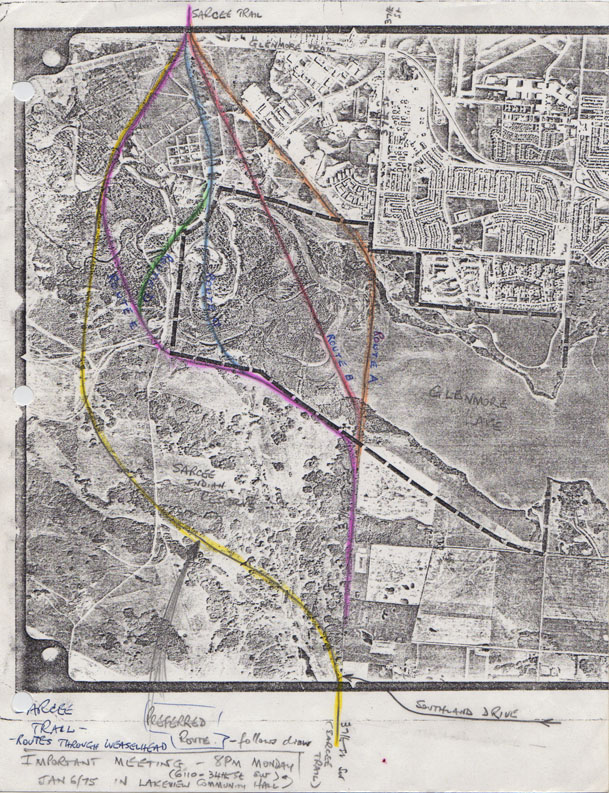
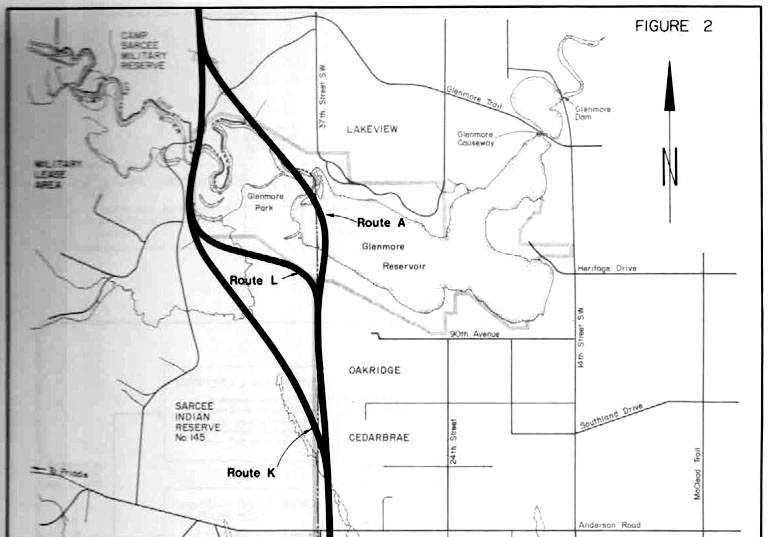
Triggered by the planning of the Midnapore area in 1974, the City of Calgary began the process of studying the potential location of the Sarcee Trail Extension, as the road was then known, that would serve the new developments south of the newly created Fish Creek park. In 1975 the City called for feedback from environmental and citizen groups on initial route locations, three of which were proposed to cut through a small portion of the Tsuut’ina reserve (The Green, Purple and Blue routes in the map shown above from 1975. The Yellow route was not an officially suggested route at that time). Several years of planning and consultation resulted in the 1977 Sarcee Trail South Route Location Study, which concluded with three potential locations for the road: one contained entirely within the City, and two that would cross the reserve (see map below).
Representatives of the Tsuut’ina, including Chief Gordon Crowchild and future-Chief Clifford Big Plume, were invited to take part in the Citizen Design Team, which reviewed, advised and made recommendations on the design of the road. These representatives attended several meetings, but declined to take a more formal role in the proceedings, so as not to give the impression that they endorsed any recommendations resulting from the study. They were directed by members of the Nation to observe and report back, but not to involve themselves in the feedback process.
Who Does the Road Benefit?
Around this time, Mayor Rod Sykes and Chief Crowchild had engaged in discussions, and had reportedly agreed on general terms under which negotiations could proceed for the acquisition of reserve land. This ‘tentative deal’ however was not supported by the City’s administration, whose vision for the road was one that would ultimately benefit the City, but not the Tsuut’ina.
In a Calgary Herald editorial in 2002, Sykes stated that his tentative agreement would have seen the City pay for and build the road on lands sold by the Nation ‘at market value’, while the reserve would gain access to the road and to the utilities that would accompany it. This would ensure that the Nation would derive as much benefit from the road as the City would. The City administration, however, objected to allowing access to the reserve and to the extension of utilities to Tsuut’ina developments adjoining the road; in Mayor Sykes’ words “What the civic administration saw then was a satellite city on our western boundary, living off our services without being subject to our standards. No kind of agreement could overcome the conflicts that would flow from subsidizing such developments.”. In the face of opposition from the administration, Sykes allowed the matter to drop.
These plans and discussions were developing at a time where the Tsuut’ina were otherwise dealing with historic land deals, and were in the process of attempting to reclaim lands that had previously been given up by the Nation. In 1976 Tsuut’ina representatives publicly stated their intentions of recovering the Harvey Barracks lands sold to the Canadian Department of National Defence in the 1950s, while efforts to have the old Priddis Trail returned to the reserve had long been in the works. The sale of these lands had been contested by the Nation as being unjust due to coercion, misrepresentation and lack of compensation. Under these reminders of the perils of past deals, there appeared to be little appetite amongst reserve residents to entertain the notion of eroding an already limited land base for a one-time benefit. In addition to the limited nature of the land, there is an intangible quality, a sacredness, that the Nation attach to the land that ensures that the sale of land is not typically viewed as a straightforward real estate transaction. Chief Crowchild’s sentiments were paraphrased in minutes of a 1975 Citizen Design Team meeting; “The concept of money exchange, or land for land is not easily resolved since every Indian on the Reserve owns the land and values its heritage and future use in a more fundamental way… (It is) a matter that has serious implications for his people and, consequently, (the Citizen Design Team) should be aware of the Band’s perception of the issue at hand.”
Leveraging the Land
Also occurring at the same time was the Nation’s embrace of economic development on the reserve. In the early 1970s, the Tsuut’ina had begun work on the Redwood Meadows residential community near Bragg Creek; a development that benefited from Provincial Highway 22 running through the reserve.
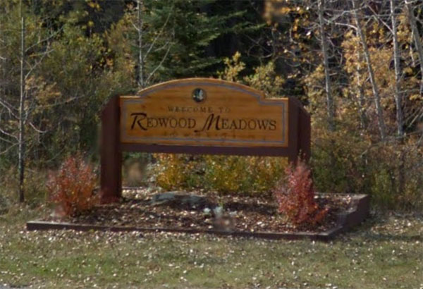
The original plan for the community included hundreds of single-family houses plus shopping, schools and a world-class golf course. The Redwood Meadows development involved no land sales; all land in the community is leased from the Nation, ensuring that while the land could be leveraged for an economic benefit, it would remain under the ownership of the Nation. The benefits for the Nation went beyond the income the development would bring to the Nation. Sarcee Developments Ltd, a wholly-owned Tsuut’ina company that was created to develop reserve lands, was seen as a potential major employer, offering jobs, training and experience to Nation members. In addressing the balance between development and the value placed on the land by Nation members, Sarcee Developments Property Manager Sidney Starlight stated in 1977 “The land is very important to the people. But they knew that to provide a future for their children they would have to turn some of it over to something like (Redwood Meadows).” The long-term provision of income and employment would a key requirement not only for this development, but seemingly for all land deals and developments going forward.
Resistance to the Road
From the outset of the Sarcee Trail Route Location Study in 1975, Chief Crowchild indicated that the Nation would not likely embrace the idea of a road through the reserve, though the door was left open to discuss the issue. Attending two meetings of the citizen design team and expressing the concerns of the Nation, Chief Crowchild made it clear that to the people of the Nation, this was not a simple real-estate deal; the land was finite, and needed to provide for both current members of the Nation and future generations to come.
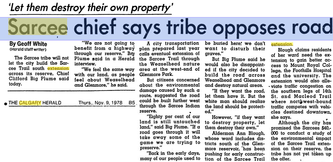
By 1978 the new Chief of the Tsuut’ina, Clifford Big Plume, went further than his predecessor in addressing the idea of a road through the reserve, by rejecting it outright. “We are not going to benefit from a highway through our reserve… We feel the same way with our lands as people feel about the Weaselhead and Glenmore.” Again, the lack of benefit to the Nation and the value attached to the Reserve were key reasons for this rejection.
The message was simple; with such a sacred, limited resource at stake, it may not be possible for the Province to obtain the land needed for a road at all. If a deal was to be made, however, the land would not only be exchanged for adequate compensation, but for a lasting and ongoing benefit to the Nation.
Looking at the Road from the Nation’s Perspective
Not satisfied that the City’s study of the Sarcee Trail Extension was being carried out with the Nation’s needs in mind, in March 1976 the Tsuut’ina announced their intention of conducting their own impact study of a road through the reserve. Seeking to interview every member of the Nation, the study was meant to look at the issue from the perspective of the Tsuut’ina; to address their particular needs and concerns, to evaluate if there would be any opportunities for the Nation to benefit from such a development, and to define what would be required from the City in order for that benefit to materialize.
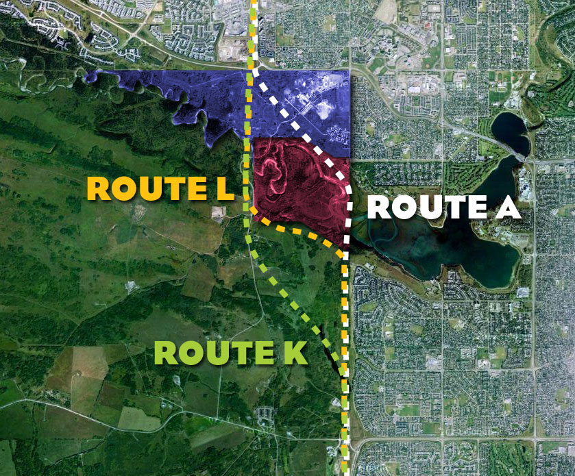
When the City’s 1977 study concluded with two of the three routes proposed through the reserve (Routes K and L above), it was noted that further refinement of the options would have to wait until the Tsuut’ina routes could be more fully evaluated. The study could not select a single alignment for the road as there were too many unknowns regarding the routes located on the reserve, including if the acquisition of the land would even be possible at all. In order to facilitate the involvement needed from the Nation to proceed, the Calgary City Council approved $40,000 to be put towards a joint study of the road, but while the Tsuut’ina hired legal council to represent their interests and draft terms of reference for negotiations, a fully independent study was never undertaken.
The Beginning of the Beginning
Despite this slowing of momentum regarding the Sarcee Trail Extension project, the parties would not have long to wait to begin the process of assessing the impacts of the ring road on the Nation. A new study was just around the corner; one that would not only address the seemingly disparate needs of the City, the Tsuut’ina and the Province, but would also kickstart the process of negotiating for a land deal in earnest.
—–
Part two of this series, covering the details and reaction to the 1984 Sarcee Trail Planning Study, can be found here.
