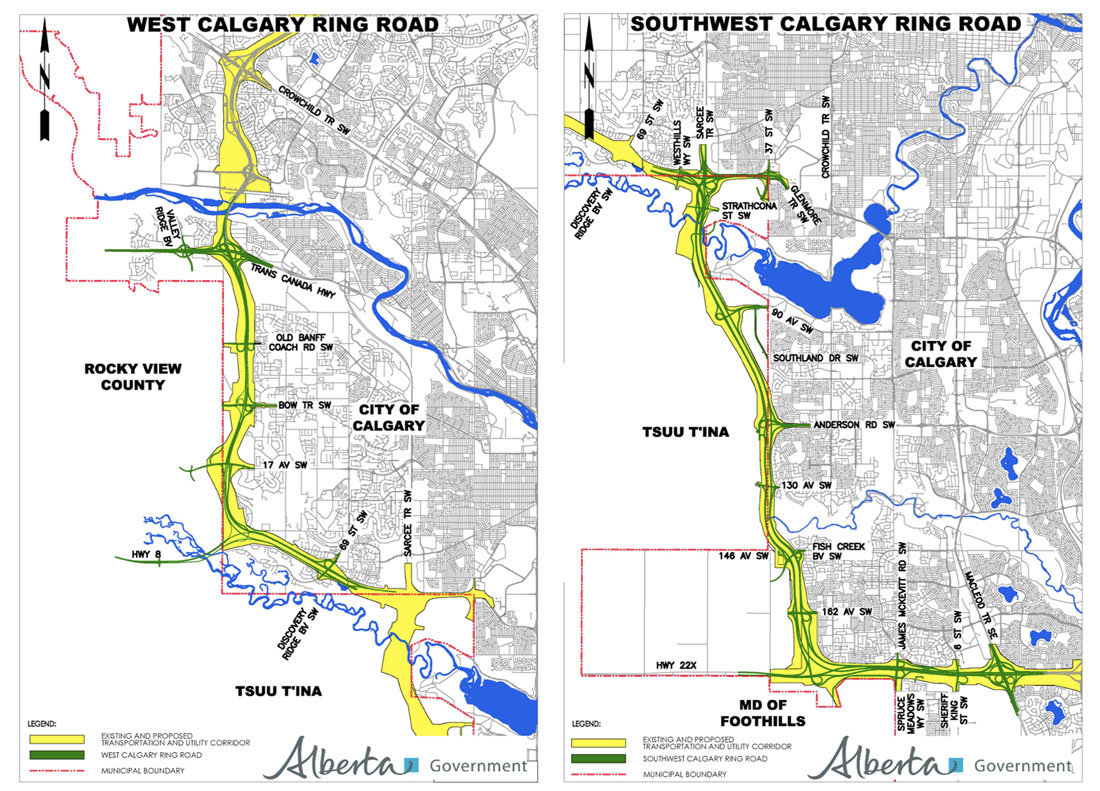
The Government of Alberta has announced that the west leg of the Calgary Ring Road, connecting Highway 8 to Highway 1, will be fully open to traffic as of December 19, 2023. This is the last of the five legs of the road to be constructed and opened, and marks the effective completion of the road, which has been 70 years in the making.
Calgary Mayor Jyoti Gondek speaks at the opening of the west leg of the Calgary Ring Road, along with (L-R) Transportation Minister Devin Dreeshen, MLA Eric Bouchard, Calgary-Lougheed, and Premier Danielle Smith
The Calgary Ring Road plan started life in the early 1950s, in response to a city experiencing rapid growth in both housing and in automobile ownership during the post-World War II era. Early road planning in the 1950s had at first been restricted to the City’s limits at that time, but by 1953, the plans were expanded to include the greater Calgary area. The map below, from December 29, 1953, or almost exactly 70 years ago, shows the earliest known regional road plan that includes a prototype ring road alignment (particularly evident on the west side of the city).
Untitled Map. December 29, 1953. City of Calgary Corporate Records, Archives. Board of Commissioners S.IV Box 189 f.39.
The ring road was not intended to be built when these plans were being developed, and was viewed as something that would be needed in a 30-year time-frame at earliest. A portion of the ring road was first approved to be built in the early 1980s, but an economic recession put those plans on hold. The first leg of the road, in Calgary’s northwest quadrant, would not see construction until 1995 (See The Ring Road System – Implementation for more information).
Over the following 28 years, the remaining legs of the road were steadily constructed. The opening of the west leg represents the culmination of plans that span half the life of the City of Calgary itself.
Next year, a new development located on the Tsuut’ina Nation reserve is set to be officially unveiled. The project, the result of a partnership between the Tsuut’ina Nation and the developer Canderel, is located along a 10km portion of the Southwest Calgary Ring Road, and is being touted as a transformative combination of retail, commercial, entertainment, health, residential and tourism amenities on Calgary’s doorstep.
District map of a development area on the Tsuut’ina reserve near Glenmore Trail, part of the Taza development. Image courtesy of the Tsuut’ina – Canderel Land Development Partnership.
Given that the development relies on access from the ring road, known as Tsuut’ina Trail as it crosses the reserve, it would be easy to see the project as a direct result of the construction of this road. However, it’s more accurate to say that the construction of the road is a direct result of the Nation’s desire to develop reserve land on Calgary’s border.
Although the proposed development is certainly a new undertaking for the Nation, the idea of developing land on the reserve’s eastern edge is one that’s been nearly 50 years in the making. The planning for both the road and the developments were initially done independently of each other, with each involved party willing, or even preferring, to proceed without the other. As time went on it became increasingly clear that neither could be completed without the other, and the two projects eventually became inseparable.
PURSUIT OF SELF-DETERMINATION
The Nation has derived economic benefit from reserve land in different ways over the years, including royalties from oil and gas extraction, land leases, and the sale of surface resources such as timber and gravel. Though important, these sources of income alone have not always provided the growing community with the resources it needed to be prosperous. In the early 1970s the Tsuut’ina Nation sought to create more ambitious economic enterprises, and looked to take advantage of the proximity of the City of Calgary to help make that happen. In recent years those plans have revolved around the Southwest Calgary Ring Road, though this was not always the case.
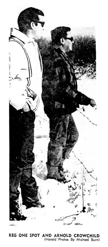
In 1970, Tsuut’ina citizens Reg One Spot and Arnold Crowchild were appointed to head up a newly-formed economic committee by the Nation’s Chief and Council.1 The committee’s mandate was to explore development opportunities on reserve lands, and to assess the benefits and drawbacks of any such initiatives.
Photo of Reg One Spot and Arnold Crowchild. Michael Burn. Calgary Herald. October 17, 1970.
For many years, portions of the Tsuut’ina reserve had generated rent under long-term leases to the Canadian Military. The Nation, however, was now looking beyond land leases. The new committee was not seeking to simply lease empty land to third-party developers, but instead were looking at ways for the Nation itself to become a developer in order to reap rewards larger than rent alone would provide. Arnold Crowchild explained their position in November of 1970; “What the tribe could get from leasing this land out may seem like considerable money, but it is only a drop in the bucket compared to what we could get if we developed it ourselves”.2
Beyond the financial benefits for the Nation as a whole, the ability to develop the land was seen as critical in improving the employment opportunities of Nation members. The Nation’s employment rate was far below that of neighbouring Calgary in the 1970s, with a reported 50-70% of the Nation unemployed, depending on the season3. “The most important thing for us right now is to create jobs for our people. We can only do this by setting up our own enterprises” the economic development team is quoted as saying.4
The east side of the Nation’s reserve, being directly adjacent to Calgary, was seen as an ideal place to explore development opportunities. This portion of the reserve benefits from its close proximity to the city, including access to potential customers and the City’s transportation network, and was viewed as some of the most viable land for commercial development. The relationship between the Nation and local city residents was noted as an important consideration for any potential development, and this relationship was to be maintained by sensitive developments. “[Our developments] would have to be clean industries so we won’t develop bad relations with our City neighbours close-by” said Mr. Crowchild and Mr. One Spot5, a position which would be reiterated by a soon-to-be-released consultant’s report.
AN INITIAL PLAN
In 1971 a $75,000 study was written by Stanley Associates Engineering Ltd.6 in order to help assess the development potential of the reserve. From this report a five-project development plan was created that was intended to unlock the commercial value of the land. This plan called for the development of:
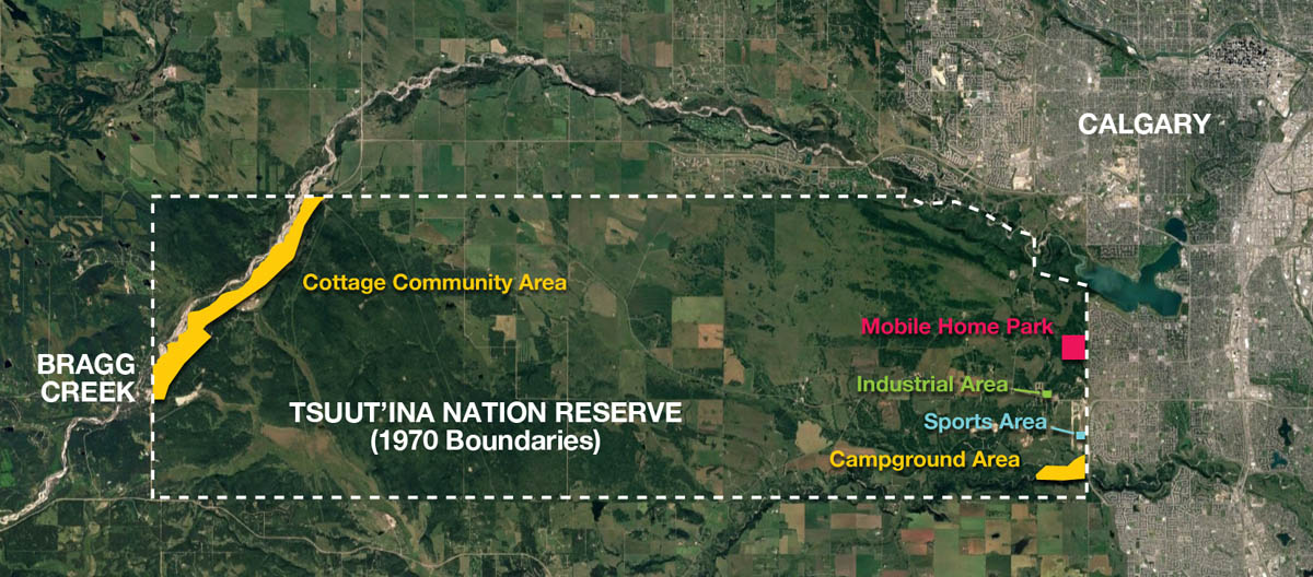
189 acres in the Southeast corner of the reserve along Fish Creek/Wolf Creek for a tent and RV campground, with a golf course and swimming facilities,
16 acres south of Anderson Road/Bull Head Road for a sports and recreation complex, including a hockey arena, tennis courts, football field and swimming pool,
160 acres adjacent to Oakridge and Cedarbrae for a mobile home park,
10 acres for an industrial park, and
1,500 acres near Bragg Creek on the reserve’s west end for a residential ‘cottage community’
Map showing five development areas on the Tsuut’ina Reserve. Source: ‘Sarcee Development Company Seeks Funds for Ambitious Project’ Kainai News. December 15, 1971. Base map: Google Maps
The study also recommended the creation of a new legal body through which the Nation could carry out its development projects. In 1971 Sarcee Developments Ltd. was established, a company wholly-owned by the Nation, with Reg One Spot and Arnold Crowchild becoming its founding directors.7
The last proposal on the consultant’s list, the ‘cottage community’ near Bragg Creek, is arguably the most economically successful of the Nations early development plans. However Redwood Meadows, as this residential and golf-course development is known, is located on the reserve’s west side, and is therefore the development least impacted by the Southwest Calgary Ring Road story. Though Redwood Meadows is deserving of its own article delving into its history, I will not be covering that story here, and will instead focus on developments found on the east side of the reserve. Continue reading “The Road to Development, part 1”
The following maps were released to the public in October of 2015 by the Province of Alberta, and rather than relying on older or historical maps of the project, I wanted to ensure that the most up-to-date information was available to readers. These are likely to remain the most current views of the road until a contractor is selected in September of this year.
Please click on the maps for larger versions.
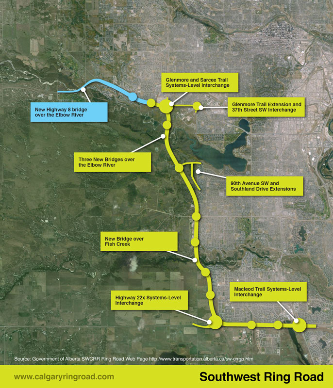
Southwest Calgary Ring Road Route
From North to South, the following maps show the full route of the Southwest Calgary Ring Road project as it currently stands:
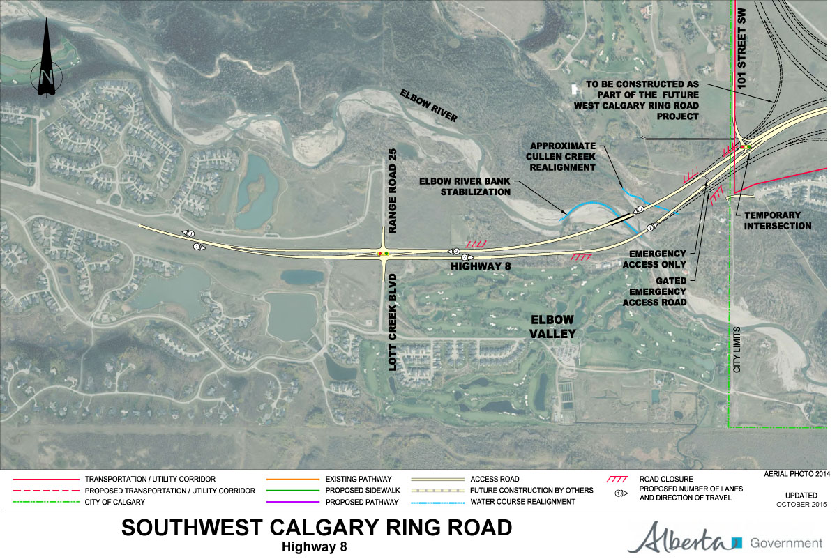
1) While not part of the Southwest Calgary Ring Road, Highway 8 from Lott Creek Boulevard to the Calgary City Limits at 101st Street SW will be twinned as part of the project, including a new bridge over the Elbow river.
2) The Southwest Ring Road begins at the Highway 8 Corridor, from Calgary City Limits at 101st Street SW, to the interchange at 69th Street SW.
3) Interchange of Glenmore Trail SW and Sarcee Trail SW, including Glenmore Trail upgrades between Sarcee Trail SW and the 37th Street SW interchange. Also shown are the interchanges with Westhills Way SW and Strathcona Street.
This article was originally published on April 15 2015. It was updated on March 5 2016 to reflect newly found information about the City’s earliest plans for bypass routes in 1952 and 1953.
The City of Calgary and the Province of Alberta variously point to planning and studies from 1959 or the 1970s as the origin of the Southwest Ring Road.1 While these studies mark important milestones in the history of this road, particularly around planning for the current iteration, the truth is that the concept is a much older one than that.
(Township plan of Bowness, Mongomery, and what would eventually become west Calgary, 1953)
Early efforts had been undertaken to plan for roads encircling Calgary’s downtown area, notably the town plan by Thomas Mawson in 1914, though these were not acted upon at the time. It wasn’t until a post-world war two explosion in population growth and vehicle ownership in Calgary had occurred that the issue of bypass roads would again be brought to the fore.
The 11-year period between 1952 and 1963 constitute the practical origin of Calgary’s bypass road system, and would see incredible effort and progress on this issue: from outright rejection, to intensive planning, and finally to construction of Calgary’s first southwest bypass route.
The Earliest Southwest Ring Road Plans
In order to address the rapid growth experienced in the post-war years, the City of Calgary began the process of creating a General Plan for the city in the late 1940s. By 1951, an interim report on the General Plan was produced, which included descriptions of primary roads planned for Calgary. A major route following 50th avenue SW across the Elbow river along the City’s southern edge and 14th street SW heading north across the Bow river2 was noted, and was intended to connect the Macleod and Banff trails and act as a bypass around the City’s core.
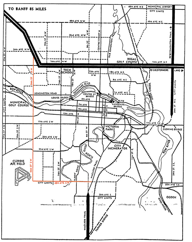
This interim report was followed by a preliminary major roads plan that was presented to City Council in the winter of 1952. The plan contained many of the same routes as the earlier General Plan interim report, though the southwest bypass was now envisioned along 24th street SW/Crowchild Trail, rather that 14th street SW, as the north-south portion of the route.3
(A depiction of Calgary’s Major Roads Plan as presented to City Council. Source: Traffic Problem Solution Seen. Nigel Dunn. Calgary Herald. December 19, 1952. Highlight added.)
Although these initial planning efforts focused on routes contained within the City’s limits, plans were simultaneously being prepared on a wider scale; the City’s major road plan was not intended as a final document, but was intended to be continually updated and expanded as conditions demanded.
The City’s planning department had earlier drafted a different map in 1952 that for the first time described the series of planned bypass roads as a ‘Ring Road System’, and indicates, though does not fully depict, a southwest bypass located on 37th street SW.4 This was an internal working document that was not intended for the public, and shows how the City had begun to look outside of it’s city limits at more regional roads.
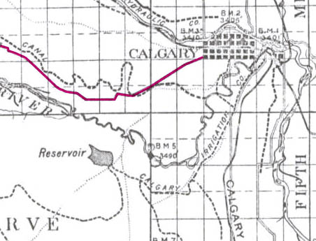
In late 1953 a further revision was completed, which for the first time fully detailed a Southwest Ring Road route around the west edge of the Glenmore reservoir.5 Comprising of 90th avenue SW on the south and 53rd street SW/Sarcee Trail on the west, this version of the Southwest Ring Road shares little in common with the modern route, though the use of the Sarcee Trail right-of-way and a crossing through the Weaselhead would remain part of the Southwest Ring Road plans for decades to follow.
(Source: Untitled Map. December 1953. City of Calgary Corporate Records, Archives. Board of Commissioners S. IV box 189 F. 39.)
By the early 1950s the City had a defined, though extremely fluid, ring road plan. Work on the plan by the City of Calgary would continue for a number of years yet, though putting the scheme into action could not be done by the City alone; implementation would require a partner in the form of the Provincial government.
Though the Southwest Calgary Ring Road is perhaps the best known Provincial road to be planned through the Tsuut’ina Nation reserve, it is not the first; over a hundred years ago another Provincial road was sought, and built, across the Nation’s land. The story of the Priddis Trail, as the early road was known, may provide some much-needed context with which to view the long negotiations for the ring road project, and perhaps to understand how the legacy of previous land agreements may have influenced the current process.
(Photo of a remnant portion of the Priddis Trail, 2015. Source: Author’s own.)
In this five-part series, I will look at the establishment of the old road through the Tsuut’ina reserve, the use and decline of the route as a public highway, and the problems surrounding the ownership and the handling of the land and the deal. Part two can be found here while Part three can be found here. I acknowledge that the resources that inform this work are largely that of non-First Nations sources, and while this is intended to be a factual look at the history of the road, it must be noted that the perspective is largely non-indigenous. I hope that further research, working with Tsuut’ina sources, will reveal other equally valid perspectives on this story in the future.
THE NEED FOR GOOD ROADS
At the turn of the century, settlers of the Priddis and Millarville areas of southern Alberta relied on well established, though informal and unmaintained, wagon trails in order to access Calgary and other areas and ranches of the region.
(Map of the Calgary area, showing the Tsuut’ina reserve and the Priddis area. Source: Google Maps.)
The provision of useful roads in the North West Territories was a constant battle for the Government, and many districts in the Territories, including Alberta, chronically suffered from poor or impassable routes. In 1900, the Department of Public Works noted this problem in its annual report:
“…so long as we have earth roads we must expect bad roads during wet seasons, and as the conditions in the Territories will not permit the construction of any other kinds of roads for many years to come it must be understood now that during certain years good roads will be an impossibility.” 1
In the midst of 1899, a notably wet year, local settlers and homesteaders called upon the Government of the North West Territories to improve and maintain a reliable road to the Priddis area. There already existed a well-used old trail between Priddis and Calgary, known locally as the Priddis Trail, or Gunawaspa Tina in Tsuut’ina, and it was this route that the locals wanted improved.2 Much like the case of the Southwest Calgary Ring Road, it was an alignment through the Tsuut’ina reserve that was seen by the Government as providing the most efficient route to serve those living south of central Calgary. In this case however, its use was reported to have predated the establishment of the reserve.3
(A map from 1897 showing the route of the Priddis Trail. Source: “Preliminary map of a portion of the District of Alberta showing Canadian irrigation surveys during 1894″. University of Alberta Libraries, Peel Map 747.)
Crossing the eastern portion of the Tsuut’ina reserve (at that time known as the Sarcee reserve) and leading diagonally from what is now the corner of Glenmore Trail and 37th street SW to a point just north of Priddis, the trail had been in use for many years by early European settlers of the area and Nation members. Like many in the North West Territories, the earthen trail suffered from regular periods of muddy and impassable conditions, and despite warnings that roads may not be improvable in the short-term, the Government had recently begun to prioritize important ‘Colonisation Roads’4 which connected newly settled areas and local market centres. Calls for the trail to be opened and improved as a public highway were heeded.
Today, the City of Calgary’s Transportation Department will present to the Transportation and Transit Committee on issues related to the yet-to-be-constructed West and Southwest Ring Road projects. As it happens, today also marks an important date in the history of the ring road. It was exactly 60 years ago that the Province of Alberta first announced plans for what would eventually become the Southwest Calgary Ring Road.
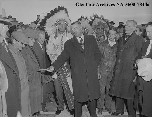
On Friday, November 18, 1955, the Calgary Chamber of Commerce held a meeting at the Palliser Hotel in downtown Calgary. Speaking at the event was Social Credit MLA and Minister of Highways Gordon Taylor, who provided a summary of the Province’s 12-month plan for highway projects in the Calgary area.
(The Hon. Gordon Taylor, Minister of Highways (Centre) shown here opening the Mewata Bridge, Calgary, 1954. Glenbow Archives NA-5600-7844a)
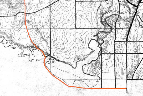
This month, the Government of Alberta revised the plans for the Southwest Calgary Ring Road Project by extending the western portion of the road into the Highway 8 corridor. This section of the ring road, what is currently Highway 8 from Sarcee trail to just west of the Calgary city limits and highlighted below in blue, had until recently been a part of the West Calgary Ring Road Project. This change shifts approximately 5km of roadway to the Southwest ring road, adds one additional interchange (69th street SW) and a new crossing over the Elbow River to the project, while removing the same from the West leg of the road.1
(The previous Southwest ring road route in green, with the addition of a portion of Highway 8 in blue, making up the most recent Southwest ring road alignment.2)
This section of Highway 8, between Sarcee trail and 101st street, has played an important role in the history of the ring road, not only recently, but for many years before.
South Morley Trail, Springbank Trail, Richmond Road and Highway 8
The modern Highway 8 partially follows the route of one of the oldest roads on Calgary’s west side. Richmond road, first known as South Morley Trail, was a key trail west of the city in the 19th century, and originally connected Calgary to the Stoney Nakoda First Nation Reserve via Springbank.3
In June of 2015, the City of Calgary will begin to construct some of the first tangible work on the Southwest Calgary Ring Road Project. This work will not be on the road itself, but will be related to utilities that will run under part of the project.
The City and Province of Alberta has agreed to construct a new storm sewer line to replace the existing South Richmond Storm Trunk that currently crosses a portion of the Tsuut’ina Nation reserve known as ‘the 940‘. The new line will be located entirely within the City of Calgary city limits along 37th street SW in Lakeview when completed, while the old line will be abandoned. This abandonment and replacement is not due to the functionality or suitability of the existing infrastructure, rather it is necessary due to reasons that are political and jurisdictional in nature; reasons that go back more than 60 years.
This article is the second in a series looking at the history of the crossing of the Elbow river near the Weaselhead. Part 1: 1956 to 1986 can be found here, and parts 3 and 4 will follow.
In the 1970s and 1980s, planning for the Southwest Calgary Ring Road, also known as the Sarcee Trail south extension, was characterized by practical considerations such as route location, land acquisition and functional planning. The period of the 1990s by contrast would be marked by something of a step-back from applied planning, and would include a serious re-examining of priorities.
The continued dominance of the automobile and the crossing of Calgary’s rivers by a network of freeways has often been seen as inevitable. This view, however, would be challenged by a renewed expression of concern over the impacts this situation would have on parks, communities and natural areas.
A New Transportation Bylaw for Calgary
In May of 1990 the City of Calgary released a preliminary look at a proposed bylaw that sought to affirm the city’s future transportation needs. In addition to public transit, bylaw 29M90 also detailed Calgary’s existing road network and plans for future expressways and freeways throughout the city. The plan was composed largely of elements from previous planning efforts, and included a map that showed proposed roads that had long been a part of City plans, including some that dated back to the early 1950s. The bylaw also contained a number of previously proposed, but as-yet unbuilt river crossings, including the southern extension of Sarcee Trail across the Elbow river. It is these crossings that would spark Calgary’s largest public consultation efforts undertaken to that point[1].
(Source: Calgary bylaw 29M90. City of Calgary, 1990)
The bylaw included the following new river crossings (also shown above): 1. Stoney Trail NW over the Bow river 2. Sarcee Trail north extension over the Bow river 3. Shaganappi Trail south extension over the Bow river 4. South Downtown Bypass over the Elbow river 5. 50th Avenue South over the Elbow river 6. Sarcee Trail south extension over the Elbow river
Public reaction to the proposed bylaw was swift and largely unfavourable, with citizen groups particularly denouncing the negative impact that new river crossings would have on parkland, river valleys, natural areas and local communities[2]. Within a month of the bylaw’s unveiling, several hundred citizens had attended a City Council meeting on the topic, and many more contacted Aldermen, signed petitions and formed action groups to oppose the plan and to call for the process to be opened up to public consultation.
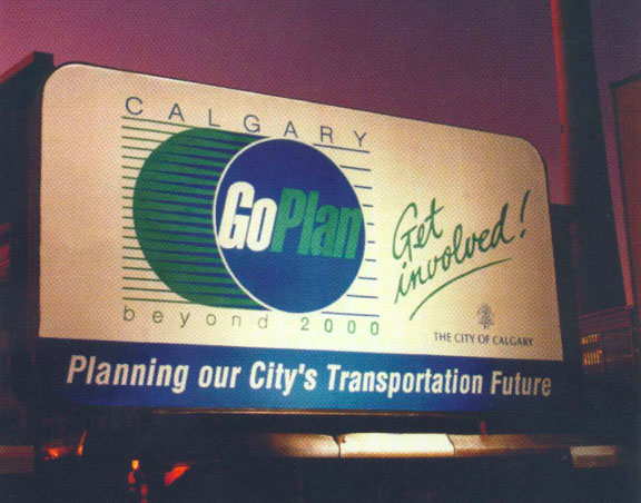
Although the bylaw was approved by Council in July 1990, the response from the public spurred the City to begin a multi-year, multi-million dollar consultation and review of the road network and future transportation needs the very next year. This process was called the GoPlan.
Alberta Transportation has announced the dates and locations for their upcoming information sessions, covering the West and Southwest Calgary Ring Road projects.