Electric Transmission Line Relocation

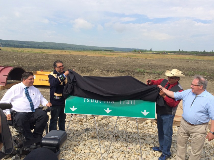
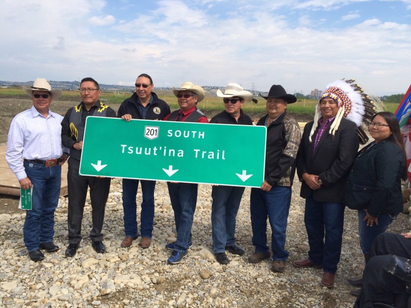
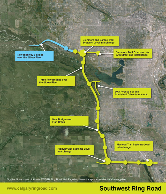
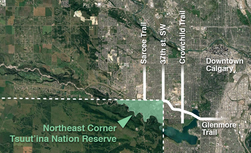
Building the Southwest Calgary Ring Road project is a massive enterprise, and includes the construction of hundreds of kilometre-lanes of roads, 49 bridges and 14 interchanges, but the project involves more than just a freeway. One of the first projects to be undertaken in preparation for the construction of the ring road involves the relocation of an electrical transmission line; one that not only crosses the ring road corridor, but also bisects the Northeast corner of the Tsuut’ina Nation reserve.

NE-corner-small
A satellite image showing the location of the northeast corner of the Tsuut’ina Nation reserve in relation to southwest Calgary. Source: Google Earth.

AltaLink, the company that owns the bulk of Alberta’s electrical transmission network, is currently in the process of installing a new underground transmission line within the right-of-ways for Glenmore Trail and 37th street SW. This work is being done in advance of the decommissioning and salvage of the portion of the existing line that crosses the reserve, and the story of how the existing line ended up on reserve land, and why it is now being removed, is an interesting one that dates back almost 100 years.

The Start of the Line

In 1924 the Calgary Power Company Ltd. planned an electric transmission line to connect their hydroelectric operations at horseshoe falls on the Bow river to south Calgary. Transmission Line No. 3 was to split off from an existing line at Jumping Pound, then head south and east for 35 kilometres to Macleod Trail at 50th avenue SW.1 Despite a few alterations over the years, this route remains largely intact and in service today.

Calgary-satelitte-jumpingpound2-wide-small
Map showing the full extend of Transmission Line No. 3, from Jumping Pound to the intersection of 50th Avenue SW and Macleod Trail. Source: Google Earth, ‘Plan showing land required for right-of-way of Transmission Line No. 3 from Jumping Pound to Calgary through Townships 23 & 24 in Ranges 1, 2, 3 & 4 all west of the fifth meridian and through the Sarcee Indian Reserve’ R.V. Heathcott. Calgary Power Company Ltd. Alberta Land Registry Plan RW176. 1924.

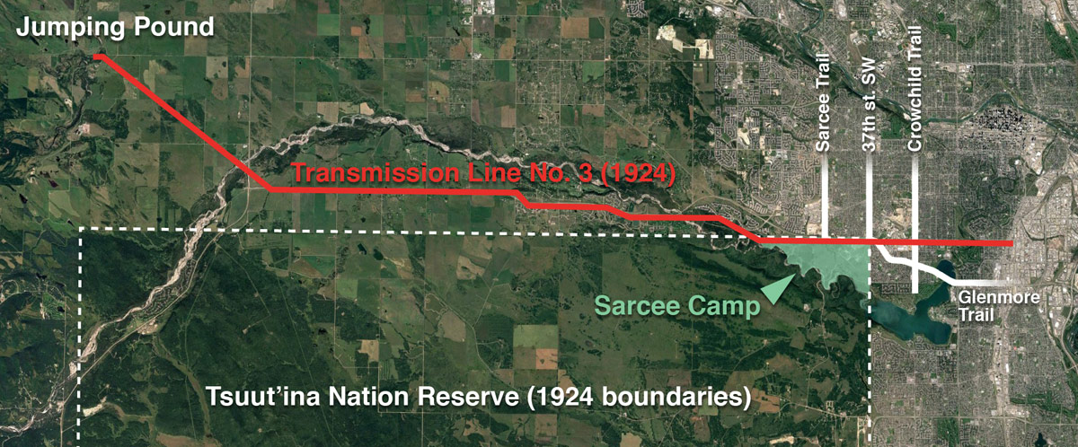
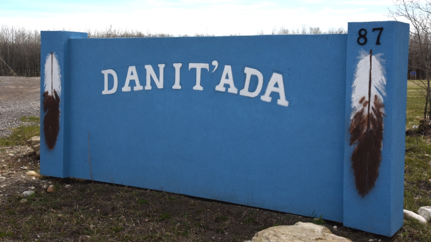
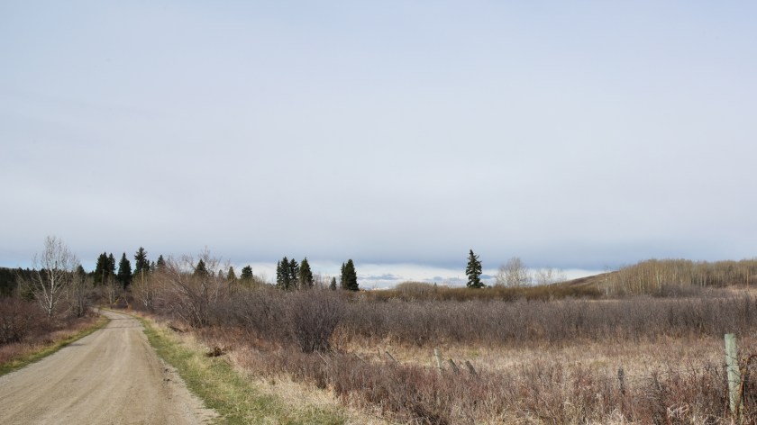
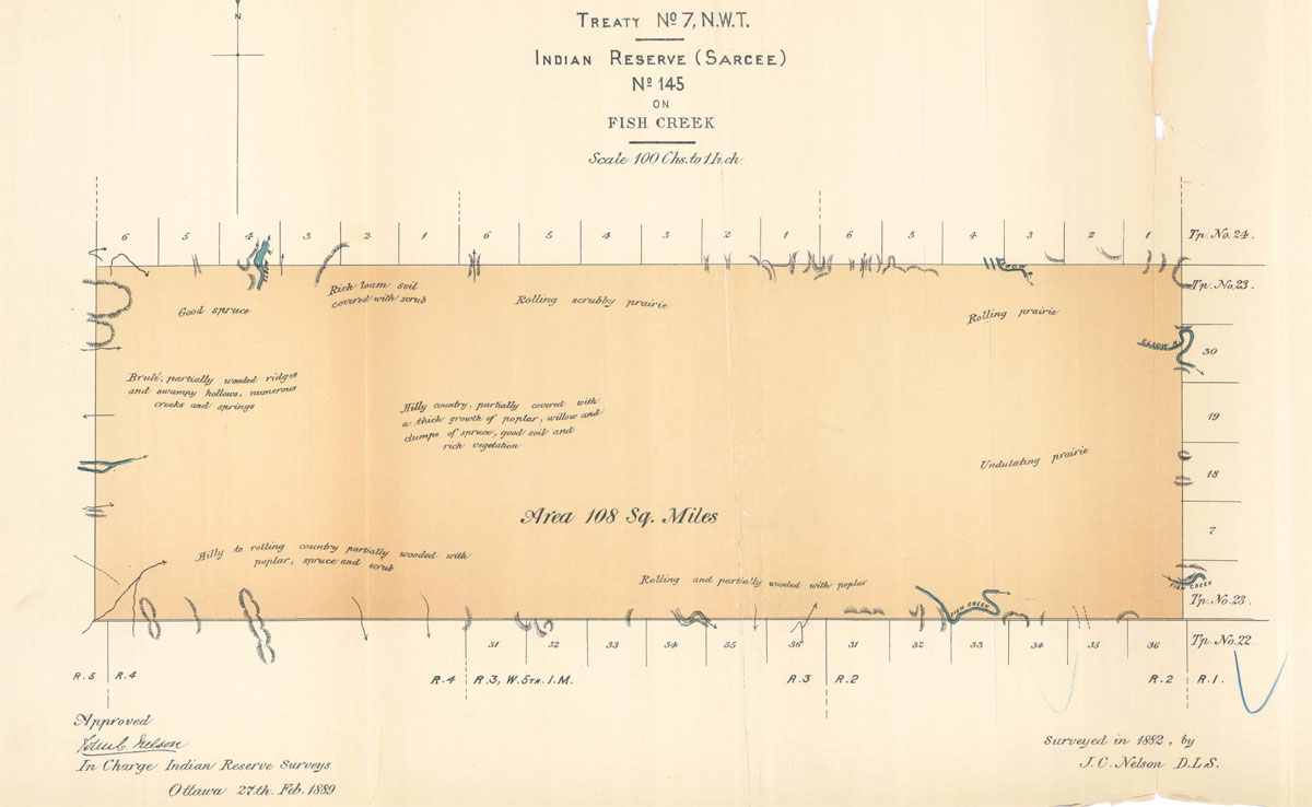
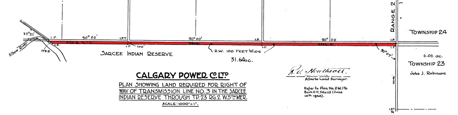
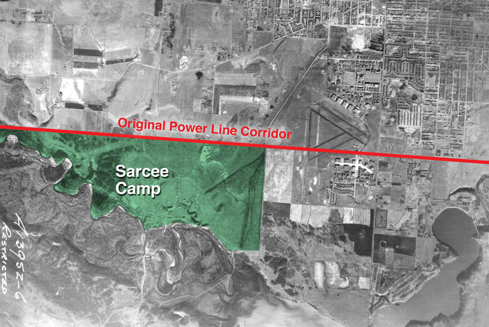
The route for the new line was surveyed, and a corridor of between 30 and 100 feet in width was allocated to the utility, including a small section that ran through the Tsuut’ina Nation reserve (then known as the Sarcee reserve). A 3.7 km portion of the line was earmarked along the northern boundary of the Nation’s land, adjacent to what is now Glenmore Trail between about 69th street SW and 37th street SW. The 100-foot-wide corridor comprised 31.6 acres of reserve land, through an area known as Sarcee Camp or The 940.2

irr2059
Survey showing the route of Transmission Line No. 3 as it crosses the Tsuut’ina Nation reserve. Source: ‘Plan showing land required for right of way of Transmission Line No. 3 in the Sarcee Indian Reserve through Tp.23 Rg.2 W5th Mer.’ R.V. Heathcott. Calgary Power Company Ltd. Canada Lands Survey Plan IRR 2059. 1924.

At the time of the survey, this part of the Tsuut’ina reserve was under lease to the Department of National Defence. Known as Sarcee Camp, the land had been turned into a training camp in 1915 in the midst of the First World War. When permission to cross this land was sought by the Calgary Power Company, the request was handled by the department of Indian Affairs, and no record of the involvement or approval of the members of the Tsuut’ina Nation are on file with the Federal Government.

The Federal Indian Commissioner valued a corridor agreement at $1000, which the Calgary Power Company paid in order to secure a perpetual easement for the power lines.3 On December 8 1924, the Superintendent General of Indian Affairs and representatives of the Calgary Power Company ratified the agreement, with the Department of National Defence signing off on a clause that would not hold the Military liable for “damage or injury done to the… transmission line… which may result from the use of the said Sarcee Camp for Military training…” and which would also compensate the Military for any damage caused by the operation of the line.4

With the survey in place and permissions acquired from other landowners along the entire route, the line was soon under construction. In 1926 the line was energized, and began to serve the increasing electricity needs of a growing modern city.

War and (Electrical) Power

Throughout the late 1920s and 1930s Transmission Line No. 3 operated unobtrusively side-by-side with Sarcee Camp. The camp was in regular use for peace-time training, but the outbreak of another war would change much on the Tsuut’ina reserve, including the transmission line.

In 1939 Canada became embroiled in World War 2, and military installations across Canada, including Sarcee Camp and the newer Currie Barracks to the north, were seeing increased use.

p_calgary6
Photo of the runways at Currie Field, with the Glenmore reservoir in the background. Source: Richard Brown. Bomber Command Museum of Canada.

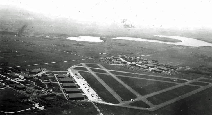
As part of the war effort, the Canadian Government earmarked Calgary as the site of a new air school. Service Flying Training School No. 3 was to be established on land directly northeast of Sarcee Camp as part of the British Commonwealth Air Training Plan,5 a scheme that would see tens of thousands of airmen trained across Canada and the world during the war. The land selected for the new air school had already seen use as an airfield for a number of years as Currie Airfield, but formal runways hadn’t been constructed up to that point.

Transmission Line No. 3 crossed directly through the chosen location for the new triangular runway of the flight school, and this overlap meant that the power lines had to move. A slight relocation of the line would not suffice as the raised power lines posed a threat to taking-off and landing aircraft,6 so a more significant move was required.

1955-step1
Aerial photo showing the location of Sarcee Camp, and of the Transmission Line No. 3 corridor that ran along the 50th avenue SW road allowance. Source: Photo A13952-6, University of Calgary Alberta Air Photo Collection. National Airphoto Library. 1955.

In June of 1940 the Acting Deputy Minister (Air Service) of the Department of National Defence asked for permission to move the transmission line further south into the reserve, bisecting the Sarcee Camp lands. Within a few days, the Deputy Minister of the Indian Affairs Branch replied with an approval of the idea, in part because the cost of the relocation would not be charged to the Nation, and also because “…this proposed diversion will not in any way interfere with the activities of the Sarcee Indians…”.7

There is no record of any approval of the relocation by Tsuut’ina Nation members, nor of the Nation being notified of the potential move. Since the Department’s approval was granted less than a week after receiving the request, there would have been insufficient time for a formal surrender to have been granted by the Nation. As this was a case of one Federal department communicating directly with another, it appears unlikely that the request ever left Ottawa.

1955-step2
Aerial photo showing the position of the relocated transmission line across Sarcee Camp, and the relative location of the Currie Barracks and the air school runways. Source: Photo A13952-6, University of Calgary Alberta Air Photo Collection. National Airphoto Library. 1955.

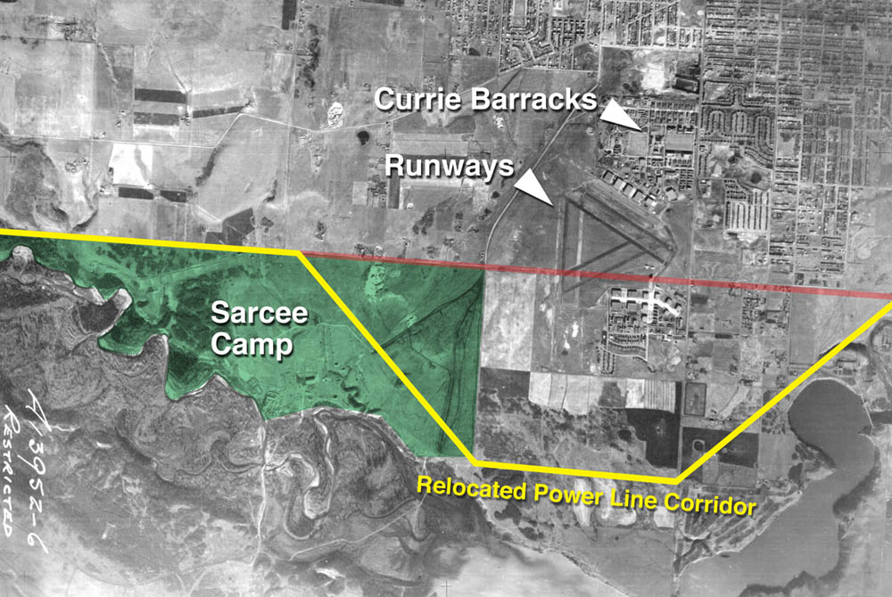
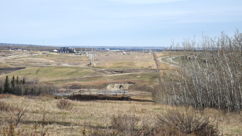
The same week that the Department granted permission for the transmission line move, the Tsuut’ina Nation’s Chief and Council made a related approval of their own. On June 19 1940, the Nation passed a Band Council Resolution approving the sale of gravel from the reserve to Dutton Brothers contractors, for use in constructing the new runways.8 Following a survey of the newly-altered power line corridor, the runways were under construction and nearly 5 km of the transmission line was shifted 1.6km south of its original corridor. The transmission line now diagonally crossed Sarcee Camp, and headed east through what would later become the community of Lakeview, only returning to its original route once it was clear of the airspace of the new air school.9

1940-rcaf
Article announcing the opening of the Service Flying Training School No. 3. Calgary Herald, October 28 1940.

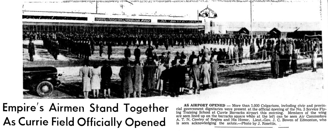
On the morning of October 28 1940, only 132 days after receiving permission to move the transmission lines, the flight school was officially opened. With the airspace clear and the runways built, the air school was ready to begin training new pilots and airmen. Continue reading “Electric Transmission Line Relocation”

Tsuut’ina Trail Officially Named

Today, a new name was unveiled for the Southwest portion of Calgary’s Ring Road, between Glenmore Trail and the Fish Creek park. Tsuut’ina Nation Chief Lee Crowchild, Calgary Mayor Naheed Nenshi, Alberta Transportation and Infrastructure Minister Brian Mason and Canada Minister of Veteran’s Affairs Kent Hehr were on hand at an official ceremony to announce that the road would be known as ‘Tsuut’ina Trail’. The ring road is currently named ‘Stoney Trail’ around the rest of the city.

IMG_3960
L-R: Kent Hehr, Naheed Nenshi, Lee Crowchild, Brian Mason.

The ceremony began after an opening prayer by Tsuut’ina elder Gerald Meguinis. The prayer spoke of safety and prosperity not just for the Nation, but for the assembled guests, and for the travellers who would soon be using the road.

meguinis
Tsuut’ina Nation Elder Gerald Meguinis, giving the opening prayer.

While the Province is officially embracing ‘Tsuut’ina Trail’ as the name for one segment of the ring road, Chief Crowchild suggested taking the renaming one step further. He stated “We believe that the entire ring road can, and should, be named Tsuut’ina (Trail)” and noted the significant role that the Nation has played in helping to get the road finished.

Transportation Minister Mason was reportedly only made aware of the idea to rename the entire road within the last day or so, and was cautious, yet willing to explore the idea. “It doesn’t take a political science graduate to see the difficulty, but certainly I’m prepared to talk to the chief and if necessary, to talk to the three chiefs and the Stoney Nation as well and if they can reach some sort of agreement, I think we can too.” he said.1

IMG_3991
Tsuut’ina Nation Chief and Council. L-R: Darrell Crowchild, LeeRoy Meguinis, Andrew Onespot, Chief Lee Crowchild, Lyle Dodginghorse, Vincent Crowchild, Leon Littlelight, Kelsey Big Plume.

Regarding the official renaming, Mayor Nenshi stated “I can’t think of a better name for this important piece of infrastructure than Tsuut’ina Trail. It is a reminder of our common path as neighbours and fellow citizens,”.2

Herald-28-1-81

Calgary’s ring road was first officially named ‘Stoney Trail’ in January of 1981, by Calgary’s City Council when the road project still fell under the City’s remit.3 Previous working-names for the southwest section of the road have included the West Bypass (1959), the Sarcee Trail Extension (1970) and the Southwest Connector (2003).

Continue reading “Tsuut’ina Trail Officially Named”

A day on the Tsuut’ina Nation reserve

On May 3rd, 2017, I was fortunate enough to accompany Hal Eagletail on a tour of the Tsuut’ina Nation reserve. Hal is a well respected cultural leader of the Tsuut’ina, and the Lakeview Community Association’s Tsuut’ina Nation Relations Committee had invited him to speak to residents about the history and culture of the Nation. Hal wanted to show certain areas of the reserve in his presentation, and as chairman of the committee, I was asked if I was interested in seeing more of the land and to take photos. I was treated to an incredible day, listening to some of the stories and walking the land of the Tsuut’ina Nation.

Any mistakes in the stories recounted in this post are mine and not Hal’s. While the post below covers some of what was presented in Hal’s talk, I recommend watching the video of the presentation, which is shown at the end of this post.

DSC_0931 Da ni t'a da

‘Danit’ada’ is the traditional Tsuut’ina greeting.

DSC_0887 cairn other angle
Rock Cairn

On the signing of Treaty 7 in 1877, the Tsuut’ina Nation was allocated a reserve adjacent to the Siksika Nation, near what is now Bassano, Alberta. After negotiating with the Federal Government for their own land, the area around Fish Creek (known as Wolf Creek to the Tsuut’ina) was selected by Tsuut’ina scouts. The scouts created a pile of rocks on a hill overlooking the creek in order to mark the land, and in 1883 when the new reserve was established, Chief Bullhead placed a rock on the pile and told all of his people to place their own rock. To this day, every Nation member continues to place a rock on the pile when they come of age, and as the Nation grows, so to does the pile.

A marker stone telling the story of the cairn was unveiled by Prince Charles in 1977.

DSC_0888 museum
New Tsuut’ina Museum

Near the rock cairn is the new Tsuut’ina Nation museum. The previous museum was established in the early 1980s, and was located in the old Seven Chiefs sportsplex building. When the sportplex was torn down a few years ago to make way for the Southwest Calgary Ring Road, the museum’s collection was put into storage to await a new home. The new museum is located just south of Chief Bullhead’s old house (built in 1909) is slated to open on Treaty Day, June 28 2017.

DSC_0891 Agents house
Indian Agent’s House

For decades, Federal employees known as Indian Agents were sent to oversee nearly every aspect of a First Nation’s business. The agent would typically live on the reserve they were sent to manage, in a house provided by the Government. This hundred-year-old Agent’s house, with its three fireplaces, was considerably larger than any other residence on the Tsuut’ina Nation reserve including the Chief’s house.

DSC_0894 residential school
Residential School Site

The lone spruce tree just to the right of the centre of the photograph above grows on the site of the old Tsuut’ina Nation reserve residential school (the Anglican St. Barnabas School). In the foreground is a thicket of yellow lilac bushes planted by the children who lived at the school.

DSC_0901 church
Anglican Church

Pictured is the third Anglican Church built on the reserve. The foundations of the second church lie to the left of the church in this photograph. The first church, established in the late 1880s, was a sod building.

DSC_0904 SWRR closer 2
Southwest Calgary Ring Road Corridor

This view, looking north, shows the new Southwest Calgary Ring Road corridor along the eastern edge of the Tsuut’ina Nation reserve. The Wolf Creek/Fish Creek valley is in the foreground, and the fence-line to the right of centre of this photo denotes the previous boundary of the reserve, adjacent to 37th street SW and the community of Woodbine. The Nation’s Administration building is visible at the left of the photo.

Hal recounted that in the 1800s a man named Eaglerib had a vision: that the land chosen for the Tsuut’ina Nation reserve would one day be surrounded by boxes, and that these boxes would allow the Nation to prosper. Over a hundred years later, the houses of Calgarians will soon surround the reserve on three sides. With the new ring road being built to provide access to future commercial developments, the growth and proximity of the City of Calgary is seen to be fulfilling Eaglerib’s vision of a coming prosperity for the Nation. Continue reading “A day on the Tsuut’ina Nation reserve”

The Rise and Fall of the Priddis Trail – Part 3: Closure

This is the third in a five-part series looking at the history of the Priddis Trail. The first part, which examined the establishment of the road can be found here. while part two, focusing on the early years of the road is here. I acknowledge that the resources that inform this work are largely that of non-First Nations sources, and in particular this article will focus on a non-indigenous perspective on the decline of the Priddis Trail. The next article will look more at the Military’s use of the Priddis Trail, while the final part looks at the problematic legacy of this road, and will begin to address the perspective not covered in this section.


Three decades after beginning life as a Government highway, the Priddis Trail was in 1930 a well-used main road that served a growing agricultural district, a burgeoning oil industry, a First Nation and an important Military training camp.

The establishment in 1900 of the road, built along the route of an old trail that crossed the Tsuut’ina Nation reserve, was originally done in order to provide reliable access to lands located southwest of Calgary. The original trail between the city and the Priddis area was notorious for its chronically poor, often impassable condition, and it was expected that upon acquiring the corridor for the road from the Tsuut’ina Nation, the Government would create and maintain a modern and reliable road. It was this desire for better access that led homesteaders to petition the government to acquire the road in the first place, and yet three decades later, this objective remained largely unfulfilled; although a road had certainly been built, it was proving far from suitable.

1926-pt(The route of the Priddis Trail (magenta) between Calgary and Millarville through the Tsuut’ina Reserve (outlined in light-pink). Source: Topographical Survey of Canada, Department of the Interior. Calgary District, Alberta. Ottawa: Department of the Interior, 1926. Peel’s Prairie Provinces Archives, University of Alberta. Map 17. Highlight added.)

The new road suffered from the same wet, periodically impassible conditions that plagued the original wagon trail. The condition of the road was exacerbated in the 1920s` by an influx of traffic brought on by an oil boom in the Turner Valley, which the Priddis Trail increasingly served. In 1930 the Province of Alberta recognized that improving the road with proper drainage and a gravelled surface would benefit both residents and industry alike, and secured funding to improve and reconstruct the road in order to make the Priddis Trail into what would soon be known as Highway 22. Continue reading “The Rise and Fall of the Priddis Trail – Part 3: Closure”

2015 Southwest Calgary Ring Road Maps

The following maps were released to the public in October of 2015 by the Province of Alberta, and rather than relying on older or historical maps of the project, I wanted to ensure that the most up-to-date information was available to readers. These are likely to remain the most current views of the road until a contractor is selected in September of this year.

Please click on the maps for larger versions.

Southwest Calgary Ring Road Route

From North to South, the following maps show the full route of the Southwest Calgary Ring Road project as it currently stands:

1) While not part of the Southwest Calgary Ring Road, Highway 8 from Lott Creek Boulevard to the Calgary City Limits at 101st Street SW will be twinned as part of the project, including a new bridge over the Elbow river.

01-SW-CRR-Highway_8


2) The Southwest Ring Road begins at the Highway 8 Corridor, from Calgary City Limits at 101st Street SW, to the interchange at 69th Street SW.

02-SW-CRR-69th_Street_SW


3) Interchange of Glenmore Trail SW and Sarcee Trail SW, including Glenmore Trail upgrades between Sarcee Trail SW and the 37th Street SW interchange. Also shown are the interchanges with Westhills Way SW and Strathcona Street.

SW-CRR - Sarcee Tr SW / Glenmore Tr SW / 37 Street SW / Westhill Continue reading “2015 Southwest Calgary Ring Road Maps”

The Rise and Fall of the Priddis Trail – Part 2: A Road In Use

This is the second in a five-part series looking at the history of the Priddis Trail. The first part, which examined the establishment of the road can be found here, and part three can be found here. I acknowledge that the resources that inform this work are largely that of non-First Nations sources, and while this is intended to be a factual look at the history of the road, it must be noted that the perspective is largely non-indigenous. I hope that further research and working with Tsuut’ina sources will reveal other equally valid perspectives on this story in the future.

—–

From Governor-Generals, Tsuut’ina Chiefs and Colonels, to Ranchers, Homesteaders and Boy Scouts, the Priddis Trail was important to a great many people for a great number of reasons. The establishment of the Tsuut’ina reserve and an early influx of Homesteaders in the late 1800s, followed not long after by the Military and a growing oil industry, meant that reliable access to a growing district was vital to the region.

map-pt-only(Map of the route between Calgary and Millarville through the Tsuut’ina Reserve in 1899. Source: ‘Plan Shewing survey of Old Trail and New Road from N.E. Cor. Sarcee Indian Reserve to Millarville P.O.’ A. P. Patrick. 1899. Plan 1119i, Alberta Land Titles, Southern Alberta Land Registration District )

BEFORE THE HIGHWAY, A TRAIL

When first formed, the route that would become the Priddis Trail was a modest dirt track used by members of the Tsuut’ina Nation and by Homesteaders living in the Priddis and Millarville districts of Alberta. Suitable for horse-and-wagon travel, the trail provided a much needed connection between these southern areas and Fort Calgary, including the burgeoning town that had begun to grow around it. In its earliest days, the land that the trail passed through had not yet been designated as the Tsuut’ina reserve1, and when the reserve was established in 1883, the use of the trail continued unabated by Tsuut’ina members and non-Indigenous settlers alike.

pa-3516-7(‘Group of visitors in wagon on the way to Sarcee (Tsuu T’ina) reserve, Alberta.’ Glenbow Archives PA-3516-7. ca. 1899)

The earliest record of the Priddis Trail comes not from the path itself, but of the trail’s crossing of the Elbow river, known as the ‘Weasel Head Crossing’. In December of 1890 a newspaper article noted the Weasel Head Crossing as the site of the butchering of stolen cattle,2 making this the first mention, albeit indirectly, of both the trail and of the ‘Weaselhead’ name that this part of the Elbow river valley would later become known by.

By 1894 the first map of the route was made by the Department of the Interior3, and soon the trail was showing up regularly in newspaper accounts and official documents. In response to questions about the trail in 1899, the acting Agent of the Sarcee Agency stated: “(Chief Bull Head) informed me the trail marked in the plan was in use by the Indians before the treaty was made with them.”4, an indication of the long use of this important connection.

PriddisTrail_1897(A map from 1897 [with added highlights] showing the route of the Priddis Trail. Source: “Preliminary map of a portion of the District of Alberta showing Canadian irrigation surveys during 1894″. University of Alberta Libraries, Peel Map 747.)

For users of the road, whether Nation members or Homesteaders, the trail enabled sustainability and economic activity by providing access to the marketplaces of Calgary. In 1893, for instance, a “comfortable dwelling house, with a good stable and corral” was built at the Weasel Head Crossing so that Tsuut’ina members had a place to stay when harvesting timber destined for sale in the City5. Former Tsuut’ina Nation Chief Sanford Big Plume also noted the use of the old trail in the Nation’s economic and cultural activities: “In the late 1800s… Once a year, Foxtail would cut small evergreens, load them on a wagon led by horses, and drive them down the Priddis Trail to Fort Calgary. There, they were sold as Christmas trees. With the proceeds of those trees, Foxtail would help fund a meal for our people, so we could also celebrate Christmas.”6

In a similar way, Homesteaders relied on the trail to bring produce and stock to market, and to access the services that the City offered.

pa-1004-18(Postcard showing a wagon on the Priddis Trail. ‘Weaselhead district, Calgary, Alberta.’ Glenbow Archive PA-1004-18. ca. 1908.)

Besides being functional, the trail was also noted to offer access to some of the more beautiful country in the area, and the use of the trail for pleasure would increase in popularity over the years. In the summer of 1895 the Governor-General of Canada Lord Aberdeen was touring the country, and by the summer of that year he had arrived in Calgary. On a morning in August, Lord and Lady Aberdeen were driven in the vice-regal carriage to a meeting with members of the Tsuut’ina Nation via the trail; the journey having been noted in the Calgary Daily Herald as “one of the prettiest drives in the N.W.T.”7. Forty years later, noted homesteader A.M. Stewart mirrored that sentiment in stating “…this road constitutes about the prettiest drive out of Calgary.”8 and the route was included in maps of automobile pleasure tours for the Calgary region.9

The still-nameless trail was increasingly well-used, and this usage would soon outstrip the ability of the trail to comfortably accommodate the traffic. By the end of the 1890s, muddy conditions on the primitive trail, ruts caused by wagon wheels and a lack of a bridge over the Elbow river would cause problems for travelers looking for unimpeded access. The un-maintained dirt track was proving to no longer be suitable for the use it was expected to accommodate, and Homesteaders living in the area soon lobbied to correct the situation. Continue reading “The Rise and Fall of the Priddis Trail – Part 2: A Road In Use”

The Rise and Fall of the Priddis Trail – Part 1: Establishment

Though the Southwest Calgary Ring Road is perhaps the best known Provincial road to be planned through the Tsuut’ina Nation reserve, it is not the first; over a hundred years ago another Provincial road was sought, and built, across the Nation’s land. The story of the Priddis Trail, as the early road was known, may provide some much-needed context with which to view the long negotiations for the ring road project, and perhaps to understand how the legacy of previous land agreements may have influenced the current process.

priddis-trail-2015(Photo of a remnant portion of the Priddis Trail, 2015. Source: Author’s own.)

In this five-part series, I will look at the establishment of the old road through the Tsuut’ina reserve, the use and decline of the route as a public highway, and the problems surrounding the ownership and the handling of the land and the deal. Part two can be found here while Part three can be found here. I acknowledge that the resources that inform this work are largely that of non-First Nations sources, and while this is intended to be a factual look at the history of the road, it must be noted that the perspective is largely non-indigenous. I hope that further research, working with Tsuut’ina sources, will reveal other equally valid perspectives on this story in the future.

THE NEED FOR GOOD ROADS

At the turn of the century, settlers of the Priddis and Millarville areas of southern Alberta relied on well established, though informal and unmaintained, wagon trails in order to access Calgary and other areas and ranches of the region.

Calgary_priddis_reserve_area_new(Map of the Calgary area, showing the Tsuut’ina reserve and the Priddis area. Source: Google Maps.)

The provision of useful roads in the North West Territories was a constant battle for the Government, and many districts in the Territories, including Alberta, chronically suffered from poor or impassable routes. In 1900, the Department of Public Works noted this problem in its annual report:

“…so long as we have earth roads we must expect bad roads during wet seasons, and as the conditions in the Territories will not permit the construction of any other kinds of roads for many years to come it must be understood now that during certain years good roads will be an impossibility.” 1

In the midst of 1899, a notably wet year, local settlers and homesteaders called upon the Government of the North West Territories to improve and maintain a reliable road to the Priddis area. There already existed a well-used old trail between Priddis and Calgary, known locally as the Priddis Trail, or Gunawaspa Tina in Tsuut’ina, and it was this route that the locals wanted improved.2 Much like the case of the Southwest Calgary Ring Road, it was an alignment through the Tsuut’ina reserve that was seen by the Government as providing the most efficient route to serve those living south of central Calgary. In this case however, its use was reported to have predated the establishment of the reserve.3

PriddisTrail_1897(A map from 1897 showing the route of the Priddis Trail. Source: “Preliminary map of a portion of the District of Alberta showing Canadian irrigation surveys during 1894″. University of Alberta Libraries, Peel Map 747.)

Crossing the eastern portion of the Tsuut’ina reserve (at that time known as the Sarcee reserve) and leading diagonally from what is now the corner of Glenmore Trail and 37th street SW to a point just north of Priddis, the trail had been in use for many years by early European settlers of the area and Nation members. Like many in the North West Territories, the earthen trail suffered from regular periods of muddy and impassable conditions, and despite warnings that roads may not be improvable in the short-term, the Government had recently begun to prioritize important ‘Colonisation Roads’4 which connected newly settled areas and local market centres. Calls for the trail to be opened and improved as a public highway were heeded.

Continue reading “The Rise and Fall of the Priddis Trail – Part 1: Establishment”

Federal Funding Announcement

On Thursday July 30 2015, Federal Minister for National Defence and Multiculturalism Jason Kenney, along with Alberta Minister for Transportation Brian Mason, announced Federal funding for the Southwest Calgary Ring Road project.

At the announcement, also attended by Tsuut’ina Chief Roy Whitney-Onespot, Kenney detailed a commitment of $582.9 million, which represents one quarter of the estimated $2.8 billion cost for construction of this leg of the road. The funds are being earmarked from the National Infrastructure Component of the New Building Canada Fund, which ‘provides funding for projects of national significance’1.

July_2015_update_new

(Map showing the newly revised route of the Southwest ring road; from Macleod trail in the south, to west of 101st street SW in the west.)

Continue reading “Federal Funding Announcement”

Treaty Day

Yesterday, June 26 2015, the Tsuut’ina Nation celebrated Treaty Day, a day of celebrations capped off with a firework finale at the Grey Eagle Entertainment Centre. The day marks the establishment of the Tsuut’ina reserve with the signing of a Treaty 132 years ago.

treaty_1883

(Articles of Surrender and Treaty – the Sarcee’s of Treaty 7 to Her Majesty – IT 332. Docket Title Page portion. 1883. Library and Archives Canada)

Treaties and Reserves

The Tsuut’ina Nation first entered into a Treaty with the British Crown in 1877 with the signing of Treaty 7 in September of that year. This Treaty initially created a reserve at Blackfoot Crossing, near Gleichen Alberta, that was to be jointly shared between the Tsuut’ina, the Siksika and the Kainai Nations1. Following the disappearance of the Buffalo from the Alberta plains in the following years, and unrest with the shared reserve, the Nation moved near Fort Calgary in 1880. The Nation endured further hardships in the years follwing the signing of Treaty 7, and in the summer of 1881 discussions began with representatives of the Canadian Government for the creation of a new and separate reserve. After scouting potential locations, the Tsuut’ina settled along the Fish Creek that fall, on land that would soon be formally granted as a reserve.2

On June 27 1883, a new Treaty, as a supplement to Treaty 7, was agreed to by Chief Bull Head, Many Horses, Eagle Robe, Big Plume and Painted Otter. The new Treaty established the Tsuut’ina Nation reserve that we know today, having been surveyed the year before, and consisting of 108 square miles of land between Calgary and Bragg Creek.3

1889-sarcee

(Tsuut’ina reserve, surveyed 1882. Descriptions and Plans of Certain Indian Reserves in the Province of Manitoba and the North-West Territories, 1889. Nelson.)

Despite several surrenders and land sales over the years, the reserve borders have remained largely the same as was first granted in 1883. The only addition of land (above the initial allocation) happened this year, as a result of the Southwest Ring Road land swap; the additional lands that were added to the reserve in May of 2015 marked the first net-increase to the reserve since its establishment.

—–

For an oral account of the events leading up to the establishment of the Tsuu T’ina reserve in 1883, you can view the excellent discussion with Tsuu T’ina elder Hal Eagletail: https://vimeo.com/40184903 (beginning at 11:52). Also see the article “The ‘Sarcee War’: Fragmented Citizenship and the City” by Patricia K. Wood.

—–

Sources

1) Treaty No. 7 (Copy of Treaty and Supplementary Treaty No. 7 between Her Majesty the Queen and the Blackfeet and Other Indian Tribes, at the Blackfoot Crossing of Bow River and Fort Macleod). 1877. Retrieved June 27 2015 http://www.aadnc-aandc.gc.ca/eng/1100100028793/1100100028803

2) The ‘Sarcee War’: Fragmented Citizenship and the City. Patricia K. Wood. 2006.

3) Articles of Surrender and Treaty – the Sarcee’s of Treaty 7 to Her Majesty. 1883. Library and Archives Canada – IT 332

SW Ring Road Land Transfer Approved

On May 1 2015 the Privy Council of Canada passed order 2015-0556, which authorizes the transfer of the proposed Southwest Ring Road corridor to the Province of Alberta. The same day, the Council passed a separate order, 2015-0557, which adds and incorporates former Alberta Crown lands into the Tsuut’ina reserve. With these two documents the land acquisition required for the Southwest Calgary Ring Road is approved.

The Province transferred $275,000,000 to the federal government in April of this year. The payment for the land will only be forwarded to the Tsuut’ina Nation, and the land title will only be assigned to the Province, once the Federal Minister of Aboriginal Affairs and Northern Development Canada signs off on the transfer.

reserve_overall_1
(Source: Canada Lands Survey Records (CLSR) 103661 January 21, 2015 and CLSR 103574-1 December 17, 2014. Image: Google Maps)

The Image above shows the new boundaries of the Tsuut’ina reserve. The original reserve (created in 1883) is shown in blue, while the newly added land (2015) is shown in magenta. The Weaselhead (1931), the Highway 22 corridor (1957) and the Southwest Ring Road corridor (2015) have been removed from the original reserve.

Moving Forward

The 2013 referendum of Tsuut’ina members, and the subsequent ratification of the agreement, meant that the Nation approved the sale and exchange of lands in order for the Province to acquire the corridor needed to build the Southwest Calgary Ring Road. Over the past 18 months, both the Province and the Nation have worked to fulfill their obligations under the agreement, in order to ensure that the land transfers would be approved by the Federal Government. Once the transfer has been enacted, which provincial representatives expect soon, the Province will have seven years in which to construct the road.

The commitment to construct the road was recently reaffirmed by former Premier Jim Prentice in the Progressive Conservative’s 2015 Provincial Budget, with construction of this leg of the ring road planned to begin as early as 2016. Though a new government is now in place, a finalized transfer of the corridor will oblige the Province to construct the road as agreed, or face the loss of the land and the money already paid.

Premier-designate Rachel Notley did not take a definitive stance on the Calgary Ring Road in the course of the 2015 election campaign, though she is quoted in relation to the ring road project as saying “In principle we are adopting the capital funding envelope and the vast majority of the commitments that the [Progressive] Conservatives have already adopted so you’d see us being in line with what’s already in the budget.” (Calgary Herald, April 29 2015, ‘Wildrose Leader Brian Jean promises to finish Calgary ring road by 2021′)

Continue reading “SW Ring Road Land Transfer Approved”