Tsuut’ina Trail portion of the Southwest Ring Road now open

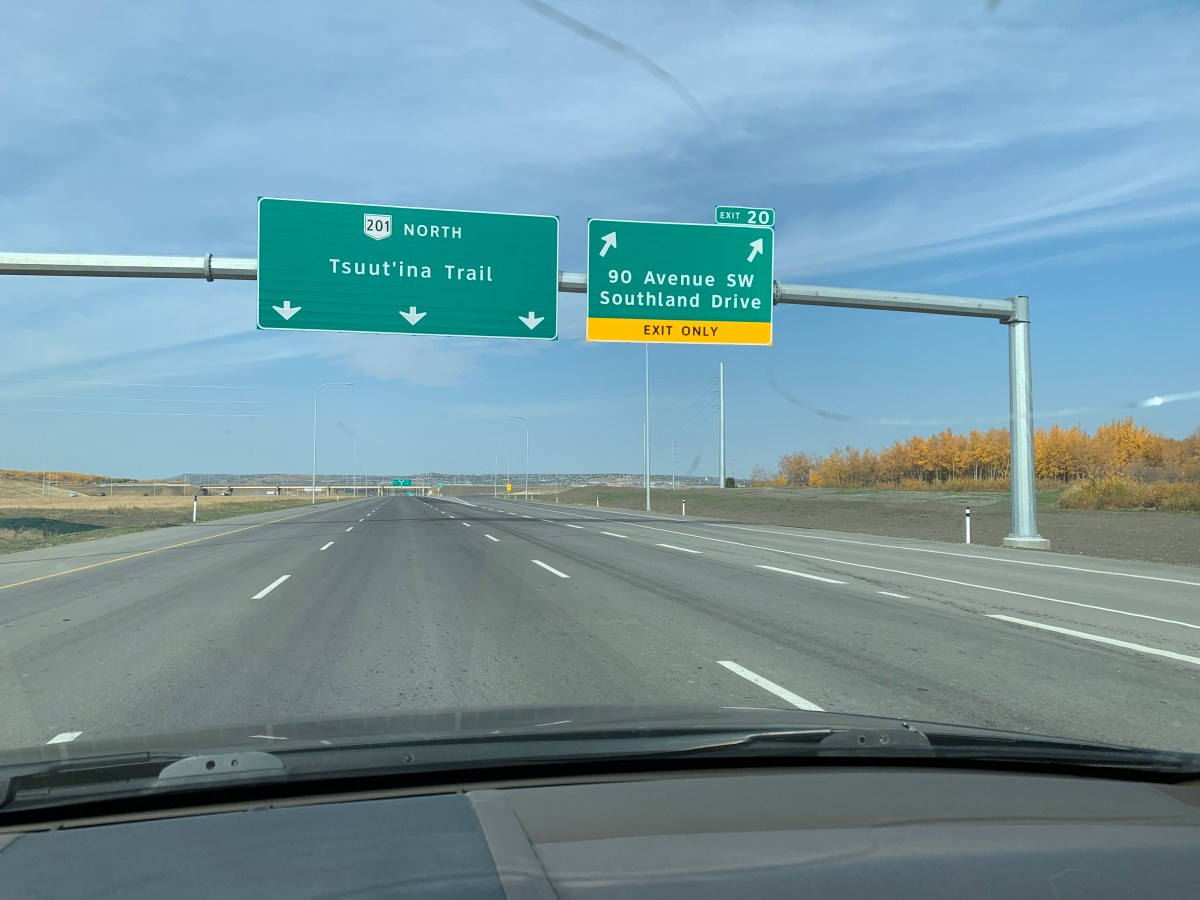
Driving the Southwest Calgary Ring Road. Northbound at the 90th Avenue SW Interchange

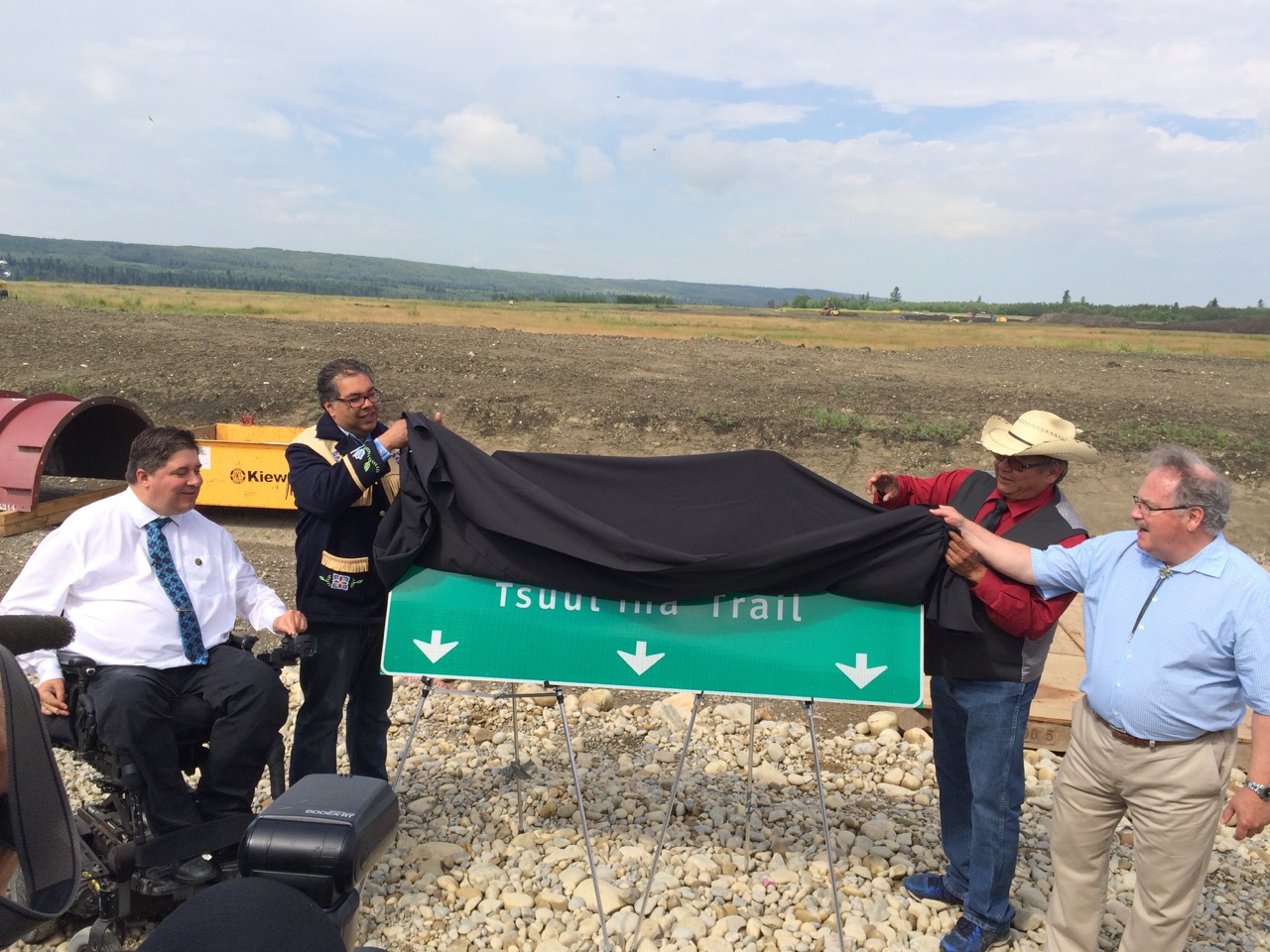
Today marked the official opening of a significant portion of Calgary’s Southwest Ring Road. Known as Tsuut’ina Trail, the road forms part of Alberta Highway 201 between Highway 8 and Fish Creek Boulevard SW. This opening is the culmination of a long and interesting story that spans the better part of 70 years (and beyond).

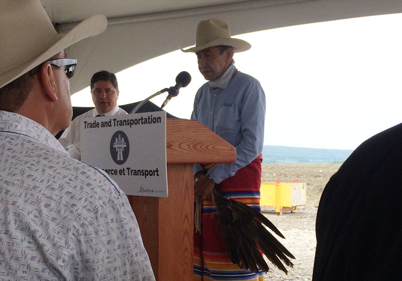
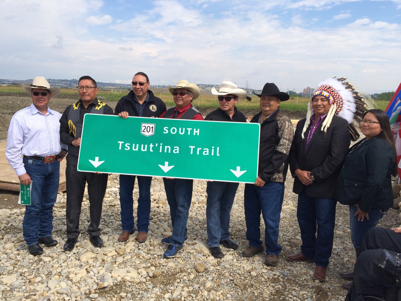
A Tsuut’ina prayer was given by Charlie Crowchild, and a safe journey song was led by Councillor Ellery Starlight to open the ceremony. This was was followed by remarks from Premier Jason Kenney, Minister of Transportation Ric McIver, Chief Roy Whitney-Onespot and Mayor Naheed Nenshi; all of whom noted the value of the road, its importance in future relations between the Nation and the City, and the significance of the long history of the project.

L-R: Alberta Minister of Transportation Ric McIver, Tsuut’ina Chief Roy Whitney Onespot and Calgary Mayor Naheed Nenshi

An unscheduled speaker, Seth Cardinal Dodginghorse, took to the podium during the ceremony in order to provide an alternative view of the project. He spoke about the loss of his childhood home and of his family having to move from the land that was required to build the ring road, after which he cut off his braids as a sign of protest.

Following the ceremony, drivers were allowed to traverse the new section of the road. These first travelers on Tsuut’ina Trail headed north from Anderson road past the 90th Avenue SW interchange, through the Weaselhead area and over the Elbow River before passing the Tsuut’ina Parkway interchange and then on to Glenmore Trail. A journey of around 4 minutes going the posted 100km/h limit.

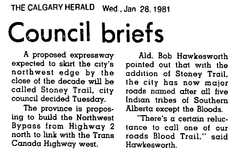
Half as old as Calgary

The origin of this road dates back to 1952 when the City first envisioned a bypass road located west of the Glenmore Reservoir. The timing is notable, as 1952 marks the halfway point in Calgary’s life; 68 years after the establishment of Calgary as a town saw the emergence of what would become the Southwest ring road, which was then opened 68 years later.

In 1952 the road was only hinted at, and it wasn’t until the following year that a bypass route was actually committed to paper.

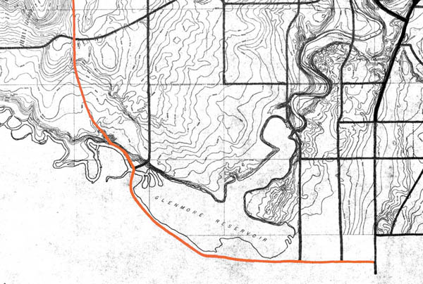
(Source: Untitled Map. December 1953. City of Calgary Corporate Records, Archives. Board of Commissioners S. IV box 189 F. 39. Highlight added to show the southwest bypass route.)

This route would be altered over the years, sometimes significantly, but some variation of a Southwest Ring Road has continued to feature in the City’s long-term planning ever since.

Now Open… Mostly

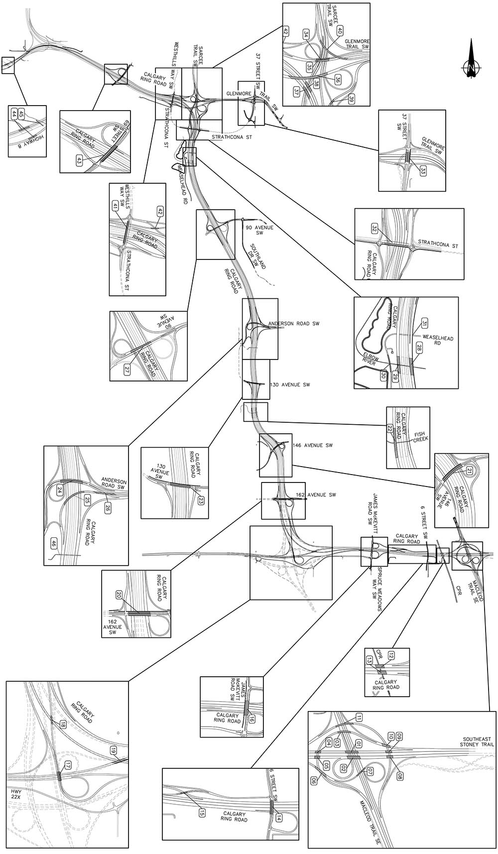
With the Tsuut’ina Trail segment of Calgary’s Ring Road open, only the portion of the Southwest leg between Fish Creek Boulevard and Highway 22x, and the West leg between Highway 8 and Highway 1 remains under construction.

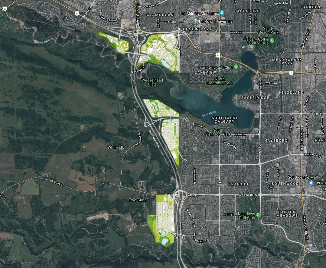
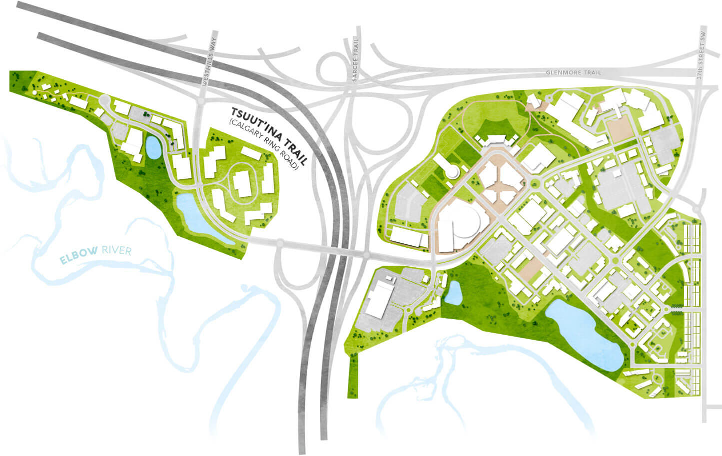
Although it has been nearly 70 years in the making and is now largely open, the story of the Southwest Ring Road is only just beginning. Tsuut’ina Trail will act as a link between the City and the Tsuut’ina Nation long into the future, not only physically, but also with the potential to bring together two communities in culture and commerce.


See these articles for more on the origins of the road, for a timeline of the project, and for a look at the Nation’s Taza commercial development project.


With thanks to Lyle Dodginghorse, Ric McIver, Darrell Crowchild, Adam Nobel-Johnson, Naheed Nenshi and Geoff Vanderberg

Advertisement

February 2019 Update

Although construction of the Southwest Calgary Ring Road has been ongoing for the past few years by the KGL Constructors partnership, it is not always easy to see what progress is being made. A large portion of the road is located on former Tsuut’ina Nation reserve land which isn’t accessible or visible to the average Calgarian, and as such, getting a sense of the work being done on this project can sometimes be difficult.

Last fall, Reddit user ‘Craftyshrew’ flew over Southwest Calgary and captured an image of the ring road project from the air. The cleared land along the route carves a visible corridor through the former reserve land, where the scale of the project, and the progress of construction, can be seen.

rr-air

(Image looking north from about Highway 22x. Click image for larger version)

At this stage in the project, construction has begun to some degree on all 14 of the interchanges along the Southwest Calgary Ring Road route, and grading for the mainline ring road lanes is approximately 45% completed. Bridge pilings have been started on many of the interchanges, with the rest commencing as the 2019 construction season begins.

Construction of all interchanges will continue into 2020, when the majority of the paving will be undertaken. The southwest portion of the ring road is scheduled to be open to the public in the fall of 2021.


Thank you to Craftyshrew on reddit for their kind permission to publish their photo, and to Adam Johnson and Rizwan Hussain from Alberta Transportation.

Taza Revealed

I have recently had the opportunity to work with the Tsuut’ina Nation-Canderel Development Partnership on some design and communications work, including the website for their upcoming Taza development. I’m pleased to see the launch of the ExperienceTaza.com website this week, which provides information on this transformative First Nations project, located right on the edge of Calgary.

EDIT February 22, 2020 – The ExperienceTaza website has been replace with the new TogetherAtTaza.com website.

EDIT December 2019 – The first tenant announced for the project is a new Costco, part of “The Shops at Buffalo Run” development located within in the Taza Exchange area near 130th avenue SW.

(For more on the origins and history of this project, see The Road to Development Part 1)

taza-1

Taza is a series of three commercial development areas, or ‘villages’, that are located on the eastern edge of the Tsuut’ina Nation reserve. From north to south, Taza Park, Taza Crossing and Taza Exchange are connected along a 9km portion of Calgary’s Southwest Ring Road, known as Tsuut’ina Trail where it crosses the reserve. The name ‘Taza’ is a Tsuut’ina word for an expression of amazement, and the development has adopted the tagline ‘Together at Tsuut’ina’.

taza-districts

The Taza development is a joint-venture between the Tsuut’ina Nation and the development company Canderel, and represents the culmination of nearly 50 years of economic development and planning by the Nation. For the story on the early years of the Nation’s economic planning, click here.

Click on the maps in the following sections for a larger version of each.

Taza Park

Taza Park is a 530-acre parcel of land located on Glenmore Trail that was previously home to the Harvey Barracks Military base. The ring road bisects Taza Park into two parcels, and the development area extends from the community of Lakeview on the east to Discovery Ridge on the west.

Access to the site is provided by three primary interchanges at 37th street SW and Glenmore Trail, at Tsuut’ina Parkway at Tsuut’ina Trail and at the new Westhills Way. Secondary access is also planned at several existing roads along 37th street SW that were originally built to provide access to the former military base.

park-full

The area is touted as a “dynamic recreation and entertainment destination” and consists of a mix of retail, dining, residential, recreational and cultural amenities. Taza Park interfaces with the existing community of Lakeview with a new lower-density residential area on the west side of 37 street SW.

The plans also feature a ‘pedestrian-friendly Market Street’, and includes a network of cycle paths, parks and artificial lakes and ponds, much of which is located overlooking the Elbow river valley and the Weaselhead area. Continue reading “Taza Revealed”

Tsuut’ina Trail Officially Named

Today, a new name was unveiled for the Southwest portion of Calgary’s Ring Road, between Glenmore Trail and the Fish Creek park. Tsuut’ina Nation Chief Lee Crowchild, Calgary Mayor Naheed Nenshi, Alberta Transportation and Infrastructure Minister Brian Mason and Canada Minister of Veteran’s Affairs Kent Hehr were on hand at an official ceremony to announce that the road would be known as ‘Tsuut’ina Trail’. The ring road is currently named ‘Stoney Trail’ around the rest of the city.

IMG_3960
L-R: Kent Hehr, Naheed Nenshi, Lee Crowchild, Brian Mason.

The ceremony began after an opening prayer by Tsuut’ina elder Gerald Meguinis. The prayer spoke of safety and prosperity not just for the Nation, but for the assembled guests, and for the travellers who would soon be using the road.

meguinis
Tsuut’ina Nation Elder Gerald Meguinis, giving the opening prayer.

While the Province is officially embracing ‘Tsuut’ina Trail’ as the name for one segment of the ring road, Chief Crowchild suggested taking the renaming one step further. He stated “We believe that the entire ring road can, and should, be named Tsuut’ina (Trail)” and noted the significant role that the Nation has played in helping to get the road finished.

Transportation Minister Mason was reportedly only made aware of the idea to rename the entire road within the last day or so, and was cautious, yet willing to explore the idea. “It doesn’t take a political science graduate to see the difficulty, but certainly I’m prepared to talk to the chief and if necessary, to talk to the three chiefs and the Stoney Nation as well and if they can reach some sort of agreement, I think we can too.” he said.1

IMG_3991
Tsuut’ina Nation Chief and Council. L-R: Darrell Crowchild, LeeRoy Meguinis, Andrew Onespot, Chief Lee Crowchild, Lyle Dodginghorse, Vincent Crowchild, Leon Littlelight, Kelsey Big Plume.

Regarding the official renaming, Mayor Nenshi stated “I can’t think of a better name for this important piece of infrastructure than Tsuut’ina Trail. It is a reminder of our common path as neighbours and fellow citizens,”.2

Herald-28-1-81

Calgary’s ring road was first officially named ‘Stoney Trail’ in January of 1981, by Calgary’s City Council when the road project still fell under the City’s remit.3 Previous working-names for the southwest section of the road have included the West Bypass (1959), the Sarcee Trail Extension (1970) and the Southwest Connector (2003).

Continue reading “Tsuut’ina Trail Officially Named”

2016 SW Ring Road Open Houses

KGL Constructors, the subcontractor responsible for the design and construction of the Southwest Calgary Ring Road, will be leading three open house sessions this month. Representatives from KGL, Alberta Transportation, and the City of Calgary will be on hand to present information about the project, and to answer questions about the progress and schedule of construction.

swcrr-schedule18-appa-36

2016 SOUTHWEST CALGARY RING ROAD INFORMATION SESSIONS:

Monday, November 28 (South Glenmore)
5:00-8:00 p.m.
Oakridge Community Hall, 9504 Oakfield Drive S.W.
View Google Map

Tuesday, November 29 (North Glenmore)
5:00-8:00 p.m.
Calgary First Church of the Nazarene, 65 Richard Way S.W.
View Google Map

Wednesday, November 30 (Deep South)
6:00-9:00 p.m.
Bishop O’Byrne High School, 333 Shawville Boulevard S.E.
View Google Map