
Though the Southwest Calgary Ring Road is perhaps the best known Provincial road to be planned through the Tsuut’ina Nation reserve, it is not the first; over a hundred years ago another Provincial road was sought, and built, across the Nation’s land. The story of the Priddis Trail, as the early road was known, may provide some much-needed context with which to view the long negotiations for the ring road project, and perhaps to understand how the legacy of previous land agreements may have influenced the current process.
 (Photo of a remnant portion of the Priddis Trail, 2015. Source: Author’s own.)
In this five-part series, I will look at the establishment of the old road through the Tsuut’ina reserve, the use and decline of the route as a public highway, and the problems surrounding the ownership and the handling of the land and the deal. Part two can be found here while Part three can be found here. I acknowledge that the resources that inform this work are largely that of non-First Nations sources, and while this is intended to be a factual look at the history of the road, it must be noted that the perspective is largely non-indigenous. I hope that further research, working with Tsuut’ina sources, will reveal other equally valid perspectives on this story in the future.
THE NEED FOR GOOD ROADS
At the turn of the century, settlers of the Priddis and Millarville areas of southern Alberta relied on well established, though informal and unmaintained, wagon trails in order to access Calgary and other areas and ranches of the region.
 (Map of the Calgary area, showing the Tsuut’ina reserve and the Priddis area. Source: Google Maps.)
The provision of useful roads in the North West Territories was a constant battle for the Government, and many districts in the Territories, including Alberta, chronically suffered from poor or impassable routes. In 1900, the Department of Public Works noted this problem in its annual report:
“…so long as we have earth roads we must expect bad roads during wet seasons, and as the conditions in the Territories will not permit the construction of any other kinds of roads for many years to come it must be understood now that during certain years good roads will be an impossibility.” 1
In the midst of 1899, a notably wet year, local settlers and homesteaders called upon the Government of the North West Territories to improve and maintain a reliable road to the Priddis area. There already existed a well-used old trail between Priddis and Calgary, known locally as the Priddis Trail, or Gunawaspa Tina in Tsuut’ina, and it was this route that the locals wanted improved.2 Much like the case of the Southwest Calgary Ring Road, it was an alignment through the Tsuut’ina reserve that was seen by the Government as providing the most efficient route to serve those living south of central Calgary. In this case however, its use was reported to have predated the establishment of the reserve.3
 (A map from 1897 showing the route of the Priddis Trail. Source: “Preliminary map of a portion of the District of Alberta showing Canadian irrigation surveys during 1894″. University of Alberta Libraries, Peel Map 747.)
Crossing the eastern portion of the Tsuut’ina reserve (at that time known as the Sarcee reserve) and leading diagonally from what is now the corner of Glenmore Trail and 37th street SW to a point just north of Priddis, the trail had been in use for many years by early European settlers of the area and Nation members. Like many in the North West Territories, the earthen trail suffered from regular periods of muddy and impassable conditions, and despite warnings that roads may not be improvable in the short-term, the Government had recently begun to prioritize important ‘Colonisation Roads’4 which connected newly settled areas and local market centres. Calls for the trail to be opened and improved as a public highway were heeded.
ACQUIRING THE ROAD
The pressure from homesteaders for better access to the Priddis area led the Government to investigate acquiring the land for the Priddis Trail, specifically the portion that crossed the Tsuut’ina reserve. Deputy Commissioner J. S. Dennis of the Department of Public Works wrote to Indian Commissioner David Laird to ask about having the corridor surveyed and transferred to the Territorial Government. In his letter, Dennis noted that while he believed that the trail could be expropriated, it would be a ‘much more simple proceeding’ for the DIA to instead consent to the survey and the transfer of the land.5 Although the Government made no mention of asking for permission from the Tsuut’ina, Laird took the issue up with the local Indian Agent, and asked if the Nation would object to the survey, and if it would be in the Nation’s interest to see the road opened as a public highway.6
Following several meetings between the Acting Indian Agent, Tsuut’ina Chief Bull Head and a minor Tsuut’ina Chief, a council of male Nation members was assembled to discuss the request.7 On May 15 1899, less than three weeks after the issue was first raised with the Nation, Tsuut’ina representatives agreed to allow the Government to build their road along the existing trail. The speed at which this decision was arrived stands in stark contrast to the decades of discussions and negotiations that resulted in the acceptance of the Southwest Calgary Ring Road.
The Priddis Trail agreement came on several conditions: First, that a bridge would be built across the Elbow river at ‘Weaselhead Crossing‘, and second; that if the corridor was to be fenced, the Nation would not be called upon to pay for the fencing.8 A third condition, that the Government would compel settlers who grazed their cattle on reserve land without permission to either pay the Nation or be removed from the land, was later dropped.9 Throughout the meeting, the Agent and the Nation members repeatedly referred to the supplied sketch of the existing trail in order to discuss which portion of the reserve the Nation members were being asked to surrender.10
 (Acceptance of surrender and attached map, Privy Council P.C. 261, February 5 1900.)
With the Nation seemingly agreed on the transfer of the land, a formal surrender was made on January 3 1900, and was accepted by the Privy Council of Canada on February 5. In the absence of a formal survey of the existing trail and a legal description of the land requirements, the Nation’s surrender noted that the 66-foot-wide corridor was ‘shown coloured in red on attached plan’, and the Order in Council stated that the strip of land was to be ‘surveyed and opened up’ for public use as a road.11
In comparison to the more than $275 million paid and the land exchange of more than 5000 acres for the Southwest Calgary Ring Road corridor, the Government had offered no compensation to the Nation for the Priddis Trail land and none was requested. Perhaps more interesting is that although the Nation surrendered their rights and interests to the land, the Territorial Government took no further steps to transfer the ownership of the corridor from the Crown.12 While the Territorial Government believed that the ownership of the land was theirs, the wording of the surrender makes no mention of the transfer or sale of the land, only that the Federal Government would hold the land in trust so that corridor would ‘be used for road purposes’.13 The ambiguity of the surrender, and of the intentions of the Nation in agreeing to the surrender, would come back to play a role later in the story of this road, which will be discussed further in Part 3.
THE FIRST SURVEY
In 1899, following the positive reception of the Tsuut’ina Nation, noted surveyor A. P. Patrick conducted a survey of the route of the Priddis Trail.14 Patrick compiled a map of the survey by the spring of 1900 (below) which showed the full extent of the corridor; capturing the existing trail’s location and detailing more fully the sketch that accompanied the surrender.15
 (Plan 1119i, Source: Alberta Land Titles, Southern Alberta Land Registration District.)
With an agreement in place, and a survey completed, it appeared that the conditions of the surrender were being fulfilled; the way was clear for the Government of the North West Territories to begin opening up the old trail as a public highway. In fact, the Government wasted no time in beginning the project, and by mid-1900 work on the road the new bridge over the Elbow river would begin.
The establishment of this route, however, would not be straightforward, and within a few years, large portions of the narrow dirt road would deviate significantly from the path of the original trail. The largest alteration occurred in north-east corner of the reserve closest to Calgary, in what is now know as the Weaselhead.
A NEW BRIDGE FOR AN OLD ROAD
Upon receiving approval from the Privy Council of Canada, The Government quickly set about establishing the road, which included constructing the bridge over the Elbow river in order to fulfill one of the conditions of the surrender. As agreed, the road followed the old trail, with the new bridge planned at the Weaselhead Crossing.
 (The Weaselhead Bridge, pictured around 1900-1903. Source: Glenbow Archives NA-2569-9)
In October of 1900, the North West Territories sent its superintendent of bridge construction to Calgary to oversee construction of the new Weaselhead Bridge.16 This 80-foot span with a 100-foot approach was the first steel road bridge constructed over the Elbow river, and was built at a cost of about $20 per foot.17
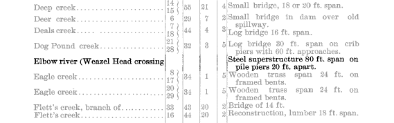 (Notice of construction of the Weaselhead Bridge, at the ‘Weazel Head Crossing’. Source: Annual Report of the Department of Public Works of the Northwest Territories, 1900. University of Alberta Libraries, Peel 9536.14)
The crossing did not immediately provide the improved travel experience that was hoped of the new bridge, with continued complaints about the condition of the approach roads on either side of the bridge. The Calgary Daily Herald noted that “…the road into (the bridge) is not at all good, the grade being too heavy”18 and within a year repairs were already being made to the new approaches. Flooding in 1902 further cut away at the banks of the river and damaged the new bridge, necessitating a repair and a lengthening of the Weaselhead bridge with an additional 40-foot span to reach the southern approach road.19
These piecemeal fixes for a problematic crossing of the river would soon not be enough to satisfy the Government, and a new direction was taken in dealing with the Weaelhead bridge. Regular spring runoff continued to impact the approach roads, making them difficult to navigate for significant periods of the year, and in the spring of 1905 action was taken. That year, the entire bridge was dismantled and moved to a new location a mile downstream, and the road followed.20
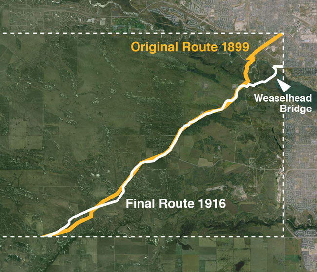 (The above map shows the route of the Patrick survey [orange] and the revised route including the Weaselhead bridge [white] that was eventually built. Source: Plans 1119i and 876-CLSR-AB)
THE SECOND, THIRD, FOURTH, FIFTH AND SIXTH SURVEYS
In the years following the completion of the Patrick survey and the opening of the road, a number of diversions were recorded by a succession of local surveyors. These alterations appear to be a combination of the Government updating their surveys to reflect the road as it was constructed, as well as the road itself being modified over the years, to provide a more suitable route (as far as settlers and the Government was concerned) through the reserve.
 (A depiction of the many surveys undertaken on the Priddis Trail between 1899 and 1916, showing the changes made over the years. Source: Plans 1119i, 6411i, 3485az, RD583-CLSR-AB, 876-CLSR-AB, 876A-CLSR-AB )
In 1902 and 1904, surveyor A. C. Talbot recorded two road diversions near the southern boundary of the Tsuut’ina reserve. The newly altered route pushed the road away from Fish Creek and was slightly less direct, requiring additional land to accommodate the changes.21 22
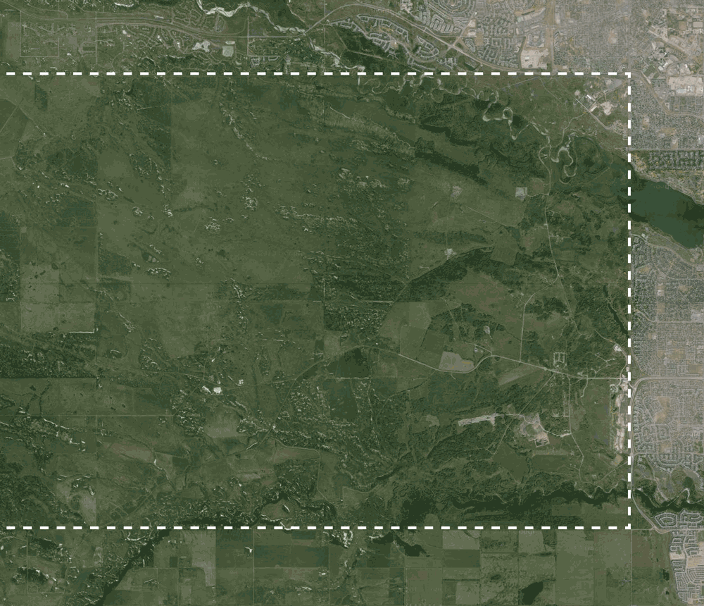
In 1905, as a result of the relocation of the Weaselhead bridge and the Priddis Trail, a new survey was undertaken to detail these changes. This new diversion was referred to as the ‘Weasel Head Road’, and represents the most significant diversion from the original survey and surrender.23 Rather than entering Calgary at the corner of what is now Glenmore Trail and 37th street SW, the road now headed east through the Weaselhead and joined 37th street SW in what is now the community of Lakeview. This plan also appears to be the last time the original Patrick route was referred to as the Priddis Trail, and soon the new Weaselhead diversion would be incorporated into the ‘final’ draft of the Priddis Trail route. This route will still look familiar to Weaselhead park users today; the modern cycle path and pedestrian bridge in the park follows the same alignment laid out for the Priddis Trail over 100 years ago.
 (A comparison of the 1905 survey of the ‘Weasel Head Road’, and a satellite photograph of the modern cycle path through the Weaselhead park. Source: Plan RD583-CLSR-AB, Google Maps.)
With an outdated ‘master’ survey and several new surveys having been made to record alignment changes, no single record accurately detailed the route of the road. After failing to make sense of the ever-changing road, the Federal Government directed the Province to instead re-survey the entire Priddis Trail and produce a ‘Final Survey’24. This was undertaken, and in the process the original 1900 Patrick survey, upon which the Tsuut’ina Nation’s surrender was granted, was discarded. Interestingly, while many other surveys of the Tsuut’ina reserve are archived in the Canada Lands Survey Records, the Patrick survey is notably absent, having never originally been provided to the Federal Government. Given the Patrick survey’s omission from Federal records, and the lack of any reference to it after about 1905, it isn’t clear if the Tsuut’ina Nation was even aware of its existence at the time it was created.
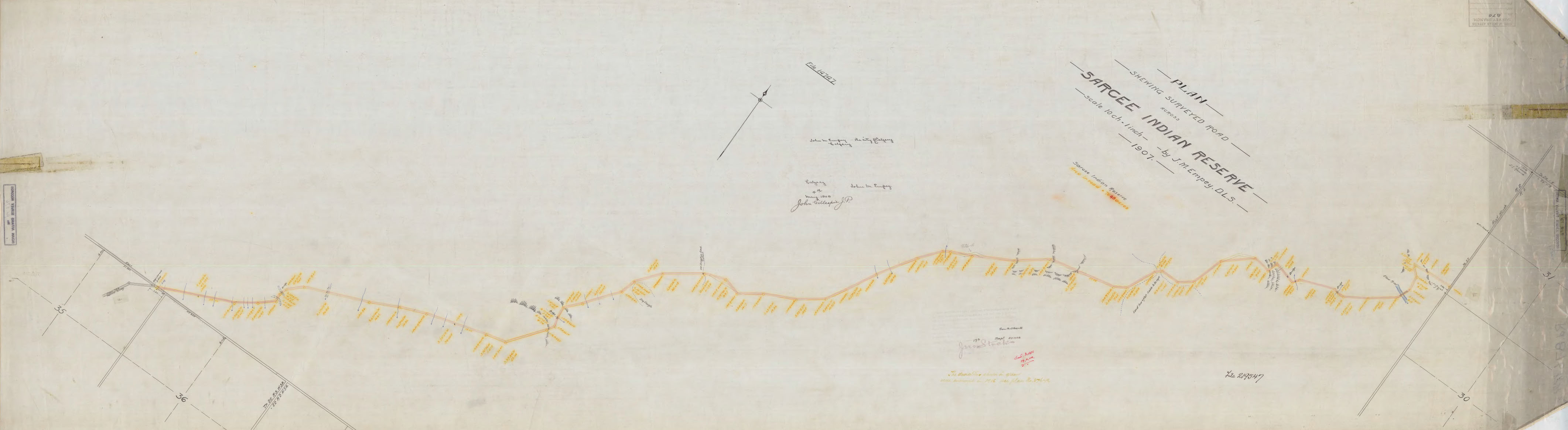 (The route of the Priddis Trail, re-surveyed in 1907. Source: Plan 876-CLSR-AB)
The new survey completed in 1907, known as Plan 876, documented the entire route within the Tsuut’ina reserve, and incorporated another round of minor adjustments to the alignment.25 A final round of revisions in 1916 known as Plan 876A would be the last survey of the route26, and all significant descriptions of the road after 1916 continue to refer to the either Plan 876 or 876A as the official route(s) of the Priddis Trail, including references by the Nation itself.27 This recognition comes despite the plans having been produced as many as 16 years after the opening of the road, and despite no further formal surrenders or land transfers having been negotiated with the Tsuut’ina Nation in order to accommodate the many changes contained therein. The lack of any further surrenders of reserve land regarding this road would point to the new diversions as having been illegally built on unsurrendered land. An informal agreement with the Nation appears to have been obtained in 1905 that would recognize the various route alterations28, although without a formal surrender, and with the 1900 surrender continuing to be referenced as the authority on which the road was built, it would appear unlikely that this ‘agreement’ carries any legal weight. (For more on the continuing fallout of the Priddis Trail diversions being built on unsurrendered land, see this article.)
The final officially-recognized route of the road contained 76.48 acres of land, a figure which changed (often increasing) several times over the life of the road.29 Though significant, this figure pales in comparison to the 1058 acres of the Southwest Calgary Ring Road corridor through Tsuut’ina Nation lands.
THE ROAD IN (AND OUT OF) SERVICE
With the road and bridge opened and the route surveyed, the Priddis Trail was officially a Territorial and Provincial public highway. The trail continued to provide much needed access to the Priddis, Millarville, and Turner Valley areas of the Province, but despite the effort in bringing the road to life, its utility was not to last. Like a great many things in southern Alberta, the Priddis Trail would see dramatic changes with the discovery of oil in the areas served by this road.
The next part of the story will look at the remarkable life and ultimate decline of this road, while the final part will look at the legacy the Priddis Trail has created; a legacy that is still being felt today
Edited November 2020 to correct and clarify the initial location of the Weaselhead Bridge, and the subsequent relocation of the bridge and the road in 1905.
Sources:
1) Annual Report of the Department of Public Works of the Northwest Territories, 1900. Government of the Northwest Territories. University of Alberta Libraries, Peel 9536.14.
2) Letter from J. S. Dennis, Deputy Commissioner, Department of Public Works of the Northwest Territories to David Laird, Indian Commissioner, April 24 1899. Public Archives Canada, Indian Affairs RG-10, Vol 3556, File 25, pt.17).
3) The acting Indian Agent stated “The Chief informed me the trail marked in the plan was in use by the indians before the treaty was made with them.” Letter from the Acting Indian Agent, Sarcee Agency, to David Laird, Indian Commissioner, May 16 1899. Public Archives Canada, Indian Affairs RG-10, Vol 3556, File 25, pt.17).
4) Annual Report of the Department of Public Works of the Northwest Territories, 1900. Government of the Northwest Territories. University of Alberta Libraries, Peel 9536.14.
5) Letter from J. S. Dennis, Deputy Commissioner, Department of Public Works of the Northwest Territories to David Laird, Indian Commissioner, April 24 1899. Public Archives Canada, Indian Affairs RG-10, Vol 3556, File 25, pt.17).
6) Letter from David Laird, Indian Commissioner, to Indian Agent A. J. McNeill, Sarcee Agency, April 26 1899. Public Archives Canada, Indian Affairs RG-10, Vol 3556, File 25, pt.17).
7) Letter from the Acting Indian Agent, Sarcee Agency, to David Laird, Indian Commissioner, May 16 1899. Public Archives Canada, Indian Affairs RG-10, Vol 3556, File 25, pt.17).
8) ‘Promise of Surrender’ by Tsuut’ina members, May 15 1899. Public Archives Canada, Indian Affairs RG-10, Vol 3556, File 25, pt.17).
9) Letter from Indian Agent A. J. McNeill, Sarcee Agency, to David Laird, Indian Commissioner, June 16 1899. Public Archives Canada, Indian Affairs RG-10, Vol 3556, File 25, pt.17).
10) Letter from the Acting Indian Agent, Sarcee Agency, to David Laird, Indian Commissioner, May 16 1899. Public Archives Canada, Indian Affairs RG-10, Vol 3556, File 25, pt.17).
11) Order in Council P.C. 261, February 4 1900.
12) Letter from D. J. Allan, Superintendent Reserves and Trusts, Department of Indian Affairs to W. M. Cory, Esq., Legal Adviser, Department of Citizenship and Immigration, January 17 1952.
13) “The Sarcee Indian To The Queen Surrender Portion of Land on Sarcee Reserve for a Road” Surrender No. 429. January 3 1900. Appended to Order in Council P.C. 261, February 4 1900.
14) “Field Notes of Survey of Old Trail and New Road. from N.E. Cor. Sarcee Res. to Millarville P.O. by A. P. Patrick D.T.S. 1899.” Provincial Archives of Alberta, GR1983.0199 Box 1, File 20.
15) 1119i. “Plan Shewing Survey of Old Trail and New Road. from N.E. Cor. Sarcee Indian Reserve to Millarville P.O.” May 23 1900. Alberta Land Titles, Southern Alberta Land Registration District.
16) “Local and General” October 2 1900. Calgary Daily Herald.
17) Annual Report of the Department of Public Works of the Northwest Territories, 1900. Government of the Northwest Territories. University of Alberta Libraries, Peel 9536.14.
18) “A Trip to Priddis” September 7, 1900. Calgary Daily Herald.
19) “Local and General” September 11, 1902. Calgary Daily Herald.
20) ‘Notice” April 10, 1905. Calgary Daily Herald.
21) 6411i. “Plan Showing Survey of a Diversion of a Surveyed Trail in the Sarcee Indian Reserve, Tp.23 Rge.3 West of 5th Mn, By A. C. Talbot D.L.S.”, Dated March 12 1903. Alberta Land Titles, Southern Alberta Land Registration District.
22) 3485az. “Plan Shewing the Survey of a Diversion of the Calgary & Priddis Trail in the Sarcee Indian Reserve, Tp.23 Rge.3 West of 5th Mn, By A. C. Talbot D.L.S., 1904”, Dated April 29 1905. Alberta Land Titles, Southern Alberta Land Registration District.
23) RD583-CLSR-AB “Plan of Weasel Head Road” by H. H. Moore, D. L. S., Dated March 27 1905. Canada Lands Survey System.
24) Letter from the J. D. McLean, Secretary of the Department of Indian Affairs, to John Stocks, Deputy Minister of the Department of Public Works of the Province of Alberta, December 6, 1905. Public Archives Canada, Indian Affairs RG-10, Vol 7736, File 23120.
25) 876-CLSR-AB. “Plan Shewing Surveyed Road across the Sarcee Indian Reserve” by J. M. Empey D.L.S., 1907, Dated May 4 1908. Canada Lands Survey System.
26) 876A-CLSR-AB. “Plan Shewing Change in Surveyed Road in Sarcee Indian Reserve” by W. H. Young D.L.S., 1916, Dated June 2 1917. Canada Lands Survey System.
27) See for instance Order in Council P.C. 1575 1/2, March 21 1952, and Order in Council P.C. 1985-3599, December 12 1985. The Tsuut’ina Nation itself references 876-CLSR-AB as the accepted route of the Priddis Trail in their 2004 land claim submission to the Federal Government: “Tsuu T’ina Nation 1931 Glenmore Reservoir Surrender” Specific Land Submission, Maurice Law Barristers & Solicitors, August 16, 2004.
28) Letter from Indian Agent A. J. McNeill, Sarcee Agency, to J. D. McLean, Secretary of the Department of Indian Affair, August 19, 1905. Public Archives Canada, Indian Affairs RG-10, Vol 7736, File 23120.
29) An additional 0.91 acres is noted on the 1902 resurvey ‘6411i’, while an additional 0.02 acres was required for the changes in the ‘876A-CLSR-AB” resurvey. Other resurveys do not note acreage changes, while the original ‘1119i’ plan does not tally the total area required from the Tsuut’ina Nation reserve. The largest diversion, the ‘Weasel Head Road’ shown on survey ‘RD583-CLSR-AB’ is noted to require an additional 13.13 acres, though no acreage is given for the portion of the trail this diversion replaced.

Another great post full of interesting information. I really like the subtle understatement of this sentence, “Like a great many things in southern Alberta, the Priddis Trail would see dramatic changes with the discovery of oil in the areas served by this road.”
Looking forward to parts II and III to follow.
I’m glad you liked the post, it’s a topic that I particularly enjoy writing about. Thank you!
This is amazing. Thank you for your work on this.