
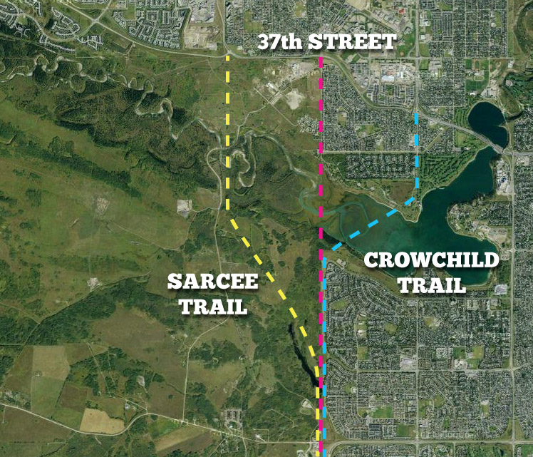
Although 37th street plays an important part in the story of the Southwest Calgary Ring Road, its discontinuous nature has meant that different parts of the road have played different roles throughout the history of the project. It is preciecly this segmentation, due to the presence of the Glenmore Reservoir, that has caused confusion over the role that 37th street plays. You will often hear comments that ’37th street was always meant to be used for the ring road’, and though partially true, in reality that only applies to the portion of the road south of the reservoir (pictured below).
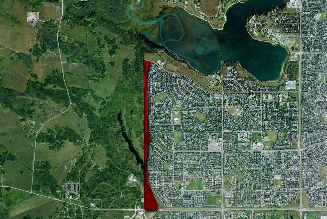
As covered in a previous article, the section of 37th street north of the reservoir has been a residential road since Lakeview, the community in which it resides, was developed in the 1960s. Despite early use as a provincial road, It has never been approved as part of the Southwest Calgary Ring Road or the Sarcee Trail extension. The portion of 37th street south of the reservoir, however, is a different story. For this article, I will cover only the portion of the 37th street corridor from 90th avenue SW to Anderson road. The portion south of Anderson road, which has its own unique history, is covered here. Unless otherwise noted, when I mention ’37th street’ I am referring to the section of 37th street SW between 90th avenue SW and Anderson Road.
SARCEE TRAIL AND 37TH STREET SW
The earliest approved road plan for Calgary, the Calgary Metropolitan Area Transportation Study of 1959, set out a long range plan for the development of road infrastructure to accomodate future growth of the City. The plan proposed the construction of a 4-lane Sarcee Trail across the Elbow river to allow for a North-South bypass of central Calgary, and to connect West Calgary to the South. While these plans made no use of 37th street north of the reservoir, the road was planned to cross the Weaselhead area and then align to the 37th street right-of-way (ROW) south of the reservoir. Variations of this alignment would be retained by the City and the Province until the 1980s.
This alignment was chosen for a reason: It follows the western border of the City, which it shares with the Tsuu T’ina Nation. This ‘city-only’alignment through the Weaselhead and along 37th street would require no land from the Nation, as it would be contained entirely within the City. Though later designs would alter this plan in the Weaselhead area, the use of a portion of the 37th street corridor for the road, between 90th avenue SW and Anderson road, would be a common aspect through the history of the road.
THE RING ROAD
A Provincial study in 1974 formalised the concept of a Transportation utility Corridor and ring road around Calgary. This study established the ring road project that we know today, and like previous studies, the southwest portion of the road originated at Sarcee Trail north of the reservoir, and aligned to the 37th street ROW to the south.
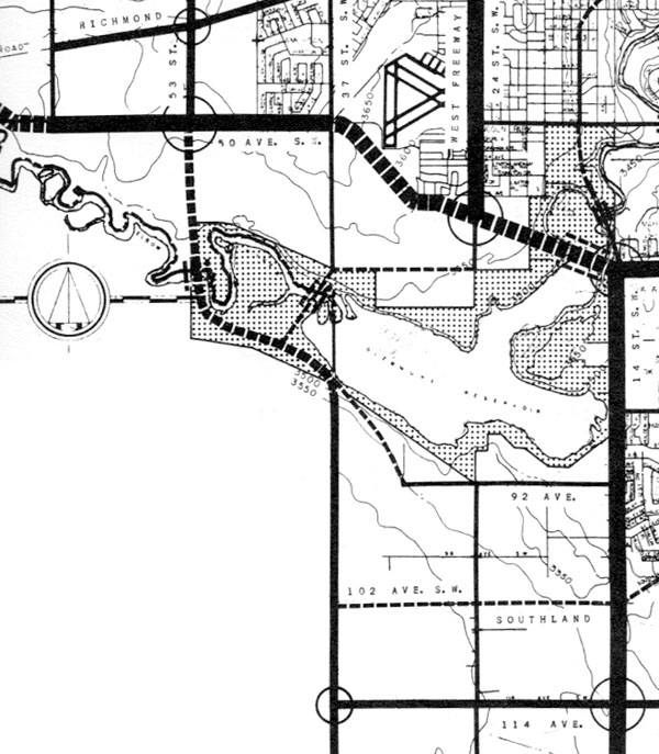
In 1976, as a response to the ring road study, the Province enacted legistlation to protect the land needed for the ring road. However, as the resultant Restricted Development Area (RDA) was established outside of the City of Calgary limits, and since Calgary had already annexed land up to and adjacent to the Tsuu T’ina Nation, the corridor in the southwest was not protected by the Province via the RDA at this time. The map below shows the gap in the RDA in the Southwest of Calgary, where the Tsuu T’ina (Sarcee) reservation is located.
Despite the lack of Provincial protection, plans were in motion to protect the 37th street ROW as a higher-capacity transportation corridor by the City, including some interesting self-imposed restrictions.
COMMUNITY DEVELOPMENT AND ‘DISTURBING’ ASSUMPTIONS
In 1973, Calgary City Council approved the Glenmore Design Brief, which set out the development framework for the communities of Bayview, Palliser, Pump Hill, Cederbrae, Braeside and Oakridge. As part of the approval process, the developer, GenStar Development Company, committed itself to the City’s Standard Development Agreement. This agreement, in part, requires developers to sell lands to the City needed for transportation uses. The Glenmore Design Brief, and the earlier Sector Plan from 1966, shows 37th street adjacent to Oakridge and Cedarbrae as the future route of the Sarcee Trail freeway, and although the land for the road was not acquired at this point, it was very much on the City’s radar.
In their February 20 1968 meeting, the City Council committee in charge of transportation planning reviewed the land required for the Sarcee Trail extension south of the reservoir. It stated that a 300 foot ROW was required to allow for a freeway-standard facility, but their recommendations stated that in addition to the 66 foot ROW that already existed, an additional 117 feet should be taken from either side of the road. This meant a total of 183 feet within the city limits, and 117 feet from the Tsuu T’ina reserve. A week later, a memo was circulated calling into question this decision. Stating that he was ‘rather disturbed’ to learn that half of the additional 37th street ROW land was to be taken from the Tsuu T’ina reserve, memo author J E Hutton asked the question “Are we sure that we can obtain 117 feet from them, when needed?”. He states “I do not think we can afford to take a chance on losing 117 feet, and recommend we take 234 feet from the Alcan (Oakridge and Cedarbrae) area” so as not to end up in a situation where the City would be forced to implement a “restricted ROW design”. This recommendation seems to have been ignored, as by April of that year, the Transit Planning Team reaffirmed their decision that half of the additional ROW land was to come from the reserve. Today the current ROW set aside for 37th street narrows to around 200 feet in places; only two thirds of the 1960s standard for a 4-lane freeway.
Following the further approval of a number of new communities in the 1970s, the City began the work of moving the Sarcee Trail extension project forward. The approval of the development of Midnapore in 1974 triggered a new study to determine the route of the road. This study, the 1977 Sarcee Trail South Route Location Study evaluated no less than a dozen different routes for the road in this area, all of which utilized at least a portion of the 37th street corridor south of the reservoir. Seven of the routes used the entire corridor from 90th avenue SW to Anderson road, with a further three occupying about a third (or less) of the corridor. (For more on the 1977 study, click here)
The 1977 study concluded without selecting a route. Of the three recommended options, only one was located entirely within City limits and utilized the entire 37th street corridor, while the other two were located at least in part on Tsuu T’ina land. Because the Tsuu T’ina Nation was not formally party to the study, the City’s access to required information about the alternative routes was limited, and conclusions could not be drawn at that time. The City recommended further study of Tsuu T’ina alignments in conjunction with the Nation before any route could be finalised.
In August of 1977, following the publication of the route location study, City Council voted to protect the 37th street ROW. While the motion specifically avoided protection of a corridor through the Weaselhead area, City commissioner George Cornish acknowledged that keeping their options open by retaining a city-only route would be in the best interest of the project.
Though some inside the City were adement that a city-only route must be preserved as a fall-back position (or a bargaining chip in dealing with the Tsuu T’ina Nation), this option was seemingly eliminated by a Council vote in 1980. The City voted to purchase the 21.62 acre road corridor from GenStar for $1.8 million, however on the third reading of the Finance and Budget (Land Matters) Committee Report ‘Land 80-270’, which authorized the purchase, Alderman Craig Reid proposed the following condition:
“That this purchase be conditional that the Sarcee Trail right-of-way not be extended through the Weaselhead Crossing options as outlined in the Sarcee Trail South Study.”
This caveat on the land purchase, which was approved by Council, effectively limited the City to building the Sarcee Trail extension through Tsuu T’ina lands, as no other alternatives had been studied at that time.
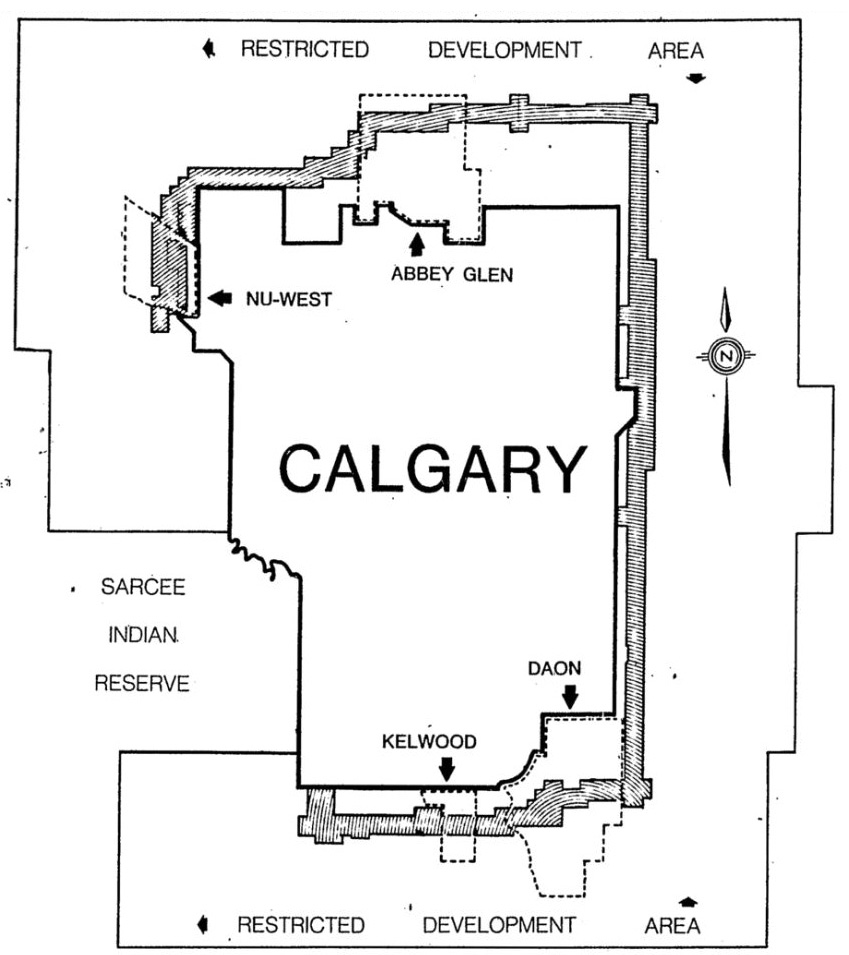
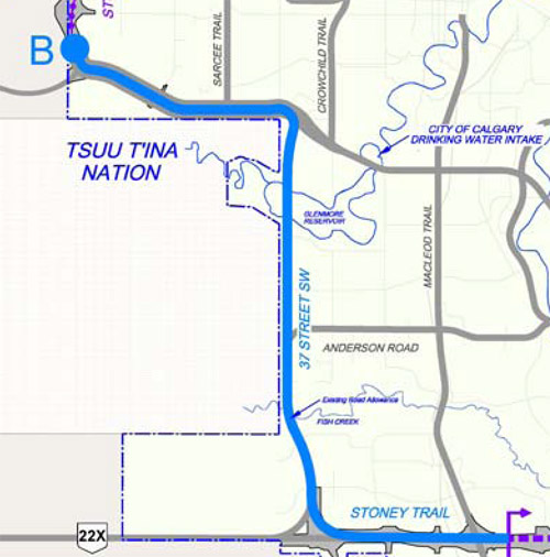
By 1984 the Tsuu T’ina Nation, the City of Calgary and the Province of Alberta concluded a new joint study of the road, and a final alignment through the Reserve was recommended (pictured below). Although this route utilized less than half of the identified 37th street ROW, the recommendation continued to justify the need to protect 37th street as a future transportation corridor.

THE 37TH STREET CYCLE PATH
After the purchase of the land, the City slowly upgraded the corridor into more than just an undeveloped parcel of land, while at the same time still protecting it as a transportation corridor for the future Sarcee Trail. A cycle path was built connecting the Glenmore Reservoir parks and the Weaselhead with Fish Creek Provincial Park, an off-leash dog park was created, and the area was maintained by the City as something of a ‘green belt’. Although by now well established, this use of the corridor was not originally intended. In 1972 the City published it’s “A Bicycle Path System for the City of Calgary” report, which was later incorporated into the Glenmore Design Brief. It detailed the location of cycle facilities in the area, and did not include 37th street SW in these plans. Despite initial plans not including it as part of the local cycle infrastructure, the 37th street corridor currently provides a more direct connection and more green space to the pathway network.
In an attempt to formalize the usage of the corridor as a cycle path, Alderman Barry Erskine asked Council to study the reclassification of this section of the 37th street corridor. His 2006 motion, which was lost only after a tie vote, read:
That Council recommend that a study to examine the merits of having the “37th Street SW Road Right-of- way” to become a “Pedestrian/Bicycle Transportation Corridor” only, after the confirmation of the land transfer for the Southwest Ring Road project.”
THE PROVINCIAL ROAD
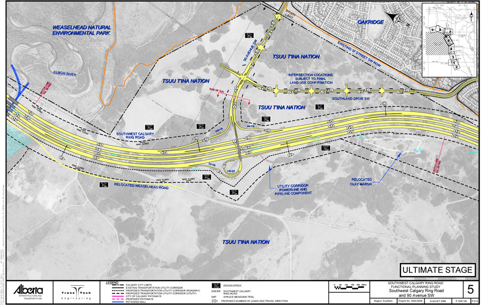
In 2004 the Province agreed to begin negotiating directly with the Tsuu T’ina Nation and started to plan the modern Southwest Calgary Ring Road. The resulting road plan, finalised in 2008, detailed a route that is based largely on the 1977 and 1984 recommended alignments. This road plan misses much of 37th street between 90th avenue and Anderson road, and only aligns to the city-owned corridor south of Southland drive. Like previous plans, both 90th avenue and Southland drive extend through the ROW in order to connect to the ring road. The diagram below shows the 37th street corridor near the top edge of the image (note the direction of North. For more images of the 2009 proposed southwest ring road alignment, click here).
Despite ultimately being voted down by the Tsuu T’ina Nation in June of 2009, and despite alternatives being proposed, this basic plan would not be sidelined for long.
CONCERNS AND ALTERNATIVES
Following the defeat of the 2009 proposal and before negotiations between the Nation and the Province resumed, the Province and City signed a Memorandum of Understanding (MOU) to begin to explore a city-only solution for the ring road. The idea of using the entire 37th street corridor for a ring road located entirely within the City of Calgary became not only a distinct possibility, but seemingly likely. The result of this MOU was the 2011 plans by the Province known informally as the ‘Plan B’ options, and although five routes were selected for study, the 37th street alignment was widely regarded as the route that best fulfilled the Province’s criteria for a ring road. More on ‘Plan B’ can be found here.
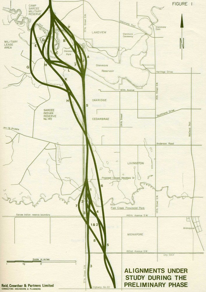
This wasn’t the first recent attempt at exploring an alternative to a Tsuu T’ina alignment, however. Dissatisfaction with the pace and terms of the previous negotiations between the City and the Tsuu T’ina Nation between 2000 and 2003 had encouraged Aldermen to seek new alternatives to a Tsuu T’ina alignment. Although not progressing past initial concept stages, all of the proposed alternatives at that time, including the proposed idea of tunnelling of the Weaselhead, utilised the 37th street corridor south of the reservoir (pictured below).
One of the significant difference between the 2011 ‘Plan B’ options and any city-only options that preceded it is the scope of the project, which caused concern for neighbouring communities. All previous plans for 37th street from the 1950s to the 1980s showed the road as a 4-lane thoroughfare (successively as an Expressway, a Freeway, and a Parkway), whereas the 2003 options were studied as a 6-lane road, and the 2011 Plan B showed the road as 8-lane Freeway. Although ideally seeking a 100 metre corridor width in which to build the ring road, the Province stated that a road of this scale (8-lanes) could be built within the existing protected 37th street ROW, which narrows to as little as 62-66 metres in places. While proponents of the ring road correctly point out that plans for the Sarcee Trail extension predate the adjacent communities, that stance does not entirely recognize the difference in scale between early plans and later proposals.
CURRENT NEGOTIATIONS AND 37TH STREET
In 2011, following community and political opposition to the ‘Plan B’ alternatives, the Tsuu T’ina Nation voted to re-engage the Province in negotiations for the ring road. While the Province has yet to release details of the route the road would take under the new negotiations, it was stated at the outset that the 2009 road plans would form the basis of new talks. Despite talk of a slightly tweaked alignment, it seems likely that at least a portion of 37th street north of Anderson road would once again be needed for the ring road.
EDIT: Since the publication of this article, in October of 2013 the Province and Tsuu T’ina have agreed to a new ring road deal. This approved route of the proposed road follows a nearly identical alignment to the 2009 plans.
—–
Thank you to Samuel Boisvert for invaluable help provided on this topic.
