
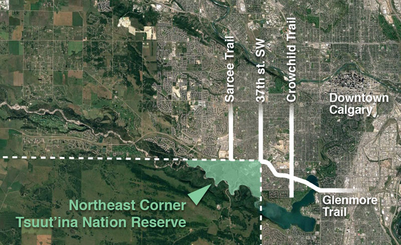
Building the Southwest Calgary Ring Road project is a massive enterprise, and includes the construction of hundreds of kilometre-lanes of roads, 49 bridges and 14 interchanges, but the project involves more than just a freeway. One of the first projects to be undertaken in preparation for the construction of the ring road involves the relocation of an electrical transmission line; one that not only crosses the ring road corridor, but also bisects the Northeast corner of the Tsuut’ina Nation reserve.
AltaLink, the company that owns the bulk of Alberta’s electrical transmission network, is currently in the process of installing a new underground transmission line within the right-of-ways for Glenmore Trail and 37th street SW. This work is being done in advance of the decommissioning and salvage of the portion of the existing line that crosses the reserve, and the story of how the existing line ended up on reserve land, and why it is now being removed, is an interesting one that dates back almost 100 years.
The Start of the Line
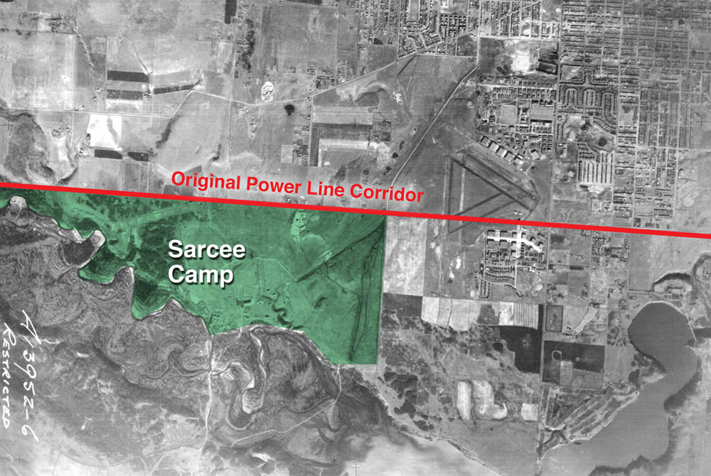
In 1924 the Calgary Power Company Ltd. planned an electric transmission line to connect their hydroelectric operations at horseshoe falls on the Bow river to south Calgary. Transmission Line No. 3 was to split off from an existing line at Jumping Pound, then head south and east for 35 kilometres to Macleod Trail at 50th avenue SW.1 Despite a few alterations over the years, this route remains largely intact and in service today.
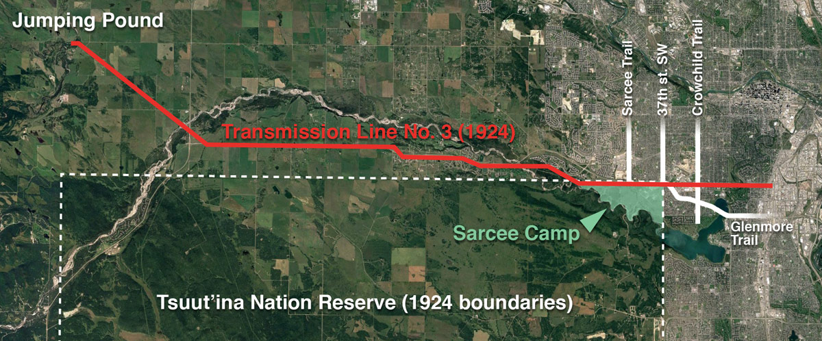
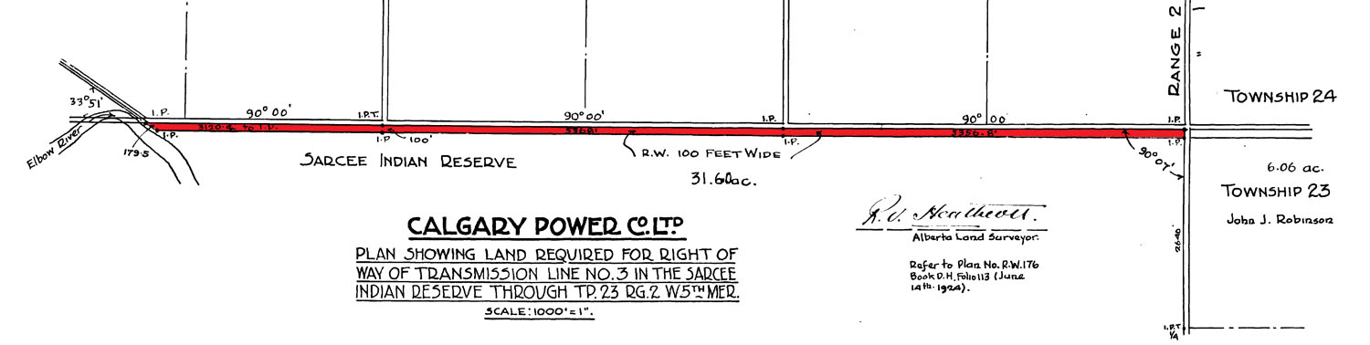
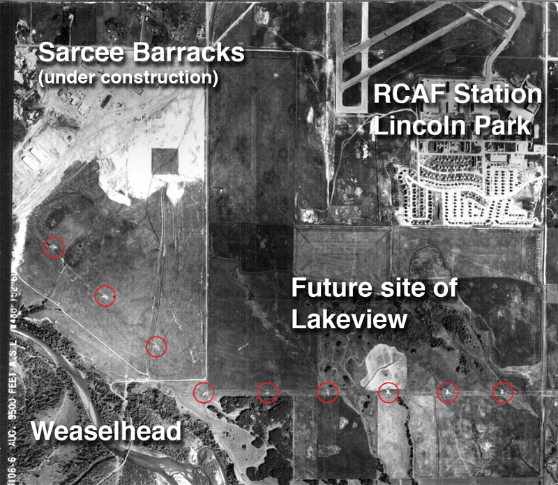
The route for the new line was surveyed, and a corridor of between 30 and 100 feet in width was allocated to the utility, including a small section that ran through the Tsuut’ina Nation reserve (then known as the Sarcee reserve). A 3.7 km portion of the line was earmarked along the northern boundary of the Nation’s land, adjacent to what is now Glenmore Trail between about 69th street SW and 37th street SW. The 100-foot-wide corridor comprised 31.6 acres of reserve land, through an area known as Sarcee Camp or The 940.2
At the time of the survey, this part of the Tsuut’ina reserve was under lease to the Department of National Defence. Known as Sarcee Camp, the land had been turned into a training camp in 1915 in the midst of the First World War. When permission to cross this land was sought by the Calgary Power Company, the request was handled by the department of Indian Affairs, and no record of the involvement or approval of the members of the Tsuut’ina Nation are on file with the Federal Government.
The Federal Indian Commissioner valued a corridor agreement at $1000, which the Calgary Power Company paid in order to secure a perpetual easement for the power lines.3 On December 8 1924, the Superintendent General of Indian Affairs and representatives of the Calgary Power Company ratified the agreement, with the Department of National Defence signing off on a clause that would not hold the Military liable for “damage or injury done to the… transmission line… which may result from the use of the said Sarcee Camp for Military training…” and which would also compensate the Military for any damage caused by the operation of the line.4
With the survey in place and permissions acquired from other landowners along the entire route, the line was soon under construction. In 1926 the line was energized, and began to serve the increasing electricity needs of a growing modern city.
War and (Electrical) Power
Throughout the late 1920s and 1930s Transmission Line No. 3 operated unobtrusively side-by-side with Sarcee Camp. The camp was in regular use for peace-time training, but the outbreak of another war would change much on the Tsuut’ina reserve, including the transmission line.
In 1939 Canada became embroiled in World War 2, and military installations across Canada, including Sarcee Camp and the newer Currie Barracks to the north, were seeing increased use.
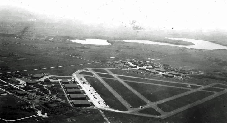
As part of the war effort, the Canadian Government earmarked Calgary as the site of a new air school. Service Flying Training School No. 3 was to be established on land directly northeast of Sarcee Camp as part of the British Commonwealth Air Training Plan,5 a scheme that would see tens of thousands of airmen trained across Canada and the world during the war. The land selected for the new air school had already seen use as an airfield for a number of years as Currie Airfield, but formal runways hadn’t been constructed up to that point.
Transmission Line No. 3 crossed directly through the chosen location for the new triangular runway of the flight school, and this overlap meant that the power lines had to move. A slight relocation of the line would not suffice as the raised power lines posed a threat to taking-off and landing aircraft,6 so a more significant move was required.
In June of 1940 the Acting Deputy Minister (Air Service) of the Department of National Defence asked for permission to move the transmission line further south into the reserve, bisecting the Sarcee Camp lands. Within a few days, the Deputy Minister of the Indian Affairs Branch replied with an approval of the idea, in part because the cost of the relocation would not be charged to the Nation, and also because “…this proposed diversion will not in any way interfere with the activities of the Sarcee Indians…”.7
There is no record of any approval of the relocation by Tsuut’ina Nation members, nor of the Nation being notified of the potential move. Since the Department’s approval was granted less than a week after receiving the request, there would have been insufficient time for a formal surrender to have been granted by the Nation. As this was a case of one Federal department communicating directly with another, it appears unlikely that the request ever left Ottawa.
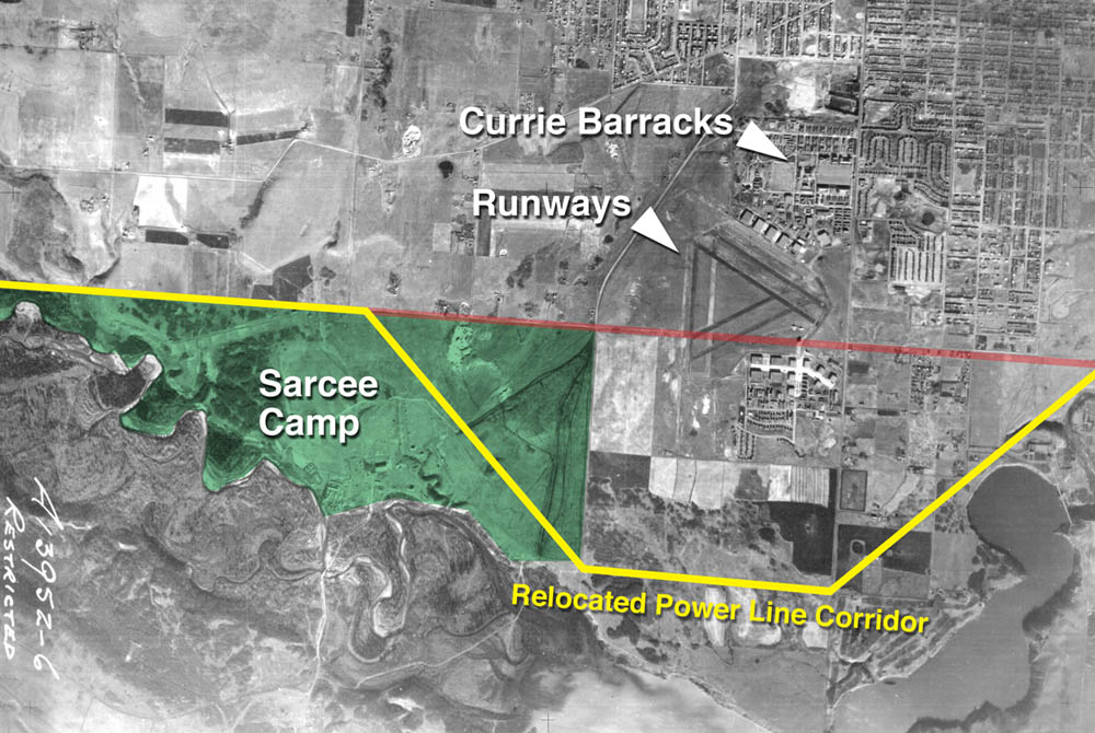
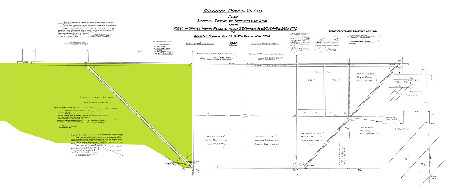
The same week that the Department granted permission for the transmission line move, the Tsuut’ina Nation’s Chief and Council made a related approval of their own. On June 19 1940, the Nation passed a Band Council Resolution approving the sale of gravel from the reserve to Dutton Brothers contractors, for use in constructing the new runways.8 Following a survey of the newly-altered power line corridor, the runways were under construction and nearly 5 km of the transmission line was shifted 1.6km south of its original corridor. The transmission line now diagonally crossed Sarcee Camp, and headed east through what would later become the community of Lakeview, only returning to its original route once it was clear of the airspace of the new air school.9
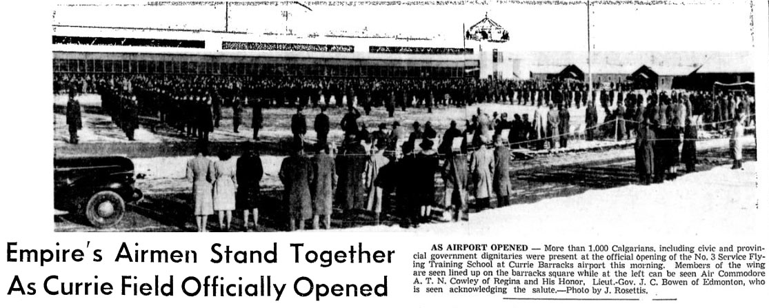
On the morning of October 28 1940, only 132 days after receiving permission to move the transmission lines, the flight school was officially opened. With the airspace clear and the runways built, the air school was ready to begin training new pilots and airmen.
Certainty of Use
The relocation of the power lines was an ad hoc solution for quickly accommodating the flights school runways, which were seen as necessary for the war effort. The informal nature of the 1940 approval lacked a legal agreement for the new corridor, and certainty was sought over the location of the lines.
In 1951 the renamed Calgary Power Ltd. applied for a formal easement for the relocated power line corridor. The 1940 survey, which set out a 100-foot-wide corridor across the northeast corner of the Tsuut’ina Nation reserve, formed the basis for the proposed legal agreement. After receiving the sum of $1 from Calgary Power, the Minister of Citizenship and Immigration (who at the time held the Indian Affairs portfolio) granted the easement.10
Both this new agreement and the original easement from 1924 granted the use of Tsuut’ina Nation reserve lands in perpetuity, and as with the previous approvals, the official written record is silent on the involvement of Tsuut’ina Nation members themselves.
Land Purchased for Sarcee Barracks
The year following the approval of the new easement was another important year for the northeast corner of the Tsuut’ina Nation reserve. With the outbreak of the Korean war in 1950, the Canadian Government had again begun to increase its military activities and to expand operations across the country. In 1952 the Department of National Defence completed a contentious purchase of the Sarcee Camp lands for $200,00011, and soon had an eye towards building a permanent barracks on the land. At that point, the land officially ceased to be a part of the Tsuut’ina Nation reserve, and continued to be subject to the 1924 and the 1951 easements for the provision of transmission lines through the area.
By 1956 the new $10 million Sarcee Barracks was under construction12 while at the same time the transmission line that crossed the barracks land was also being updated.13 The line’s older wood poles were replaced with large steel towers, and the capacity of the line was increased.
Lakeview and the Lines
The other significant piece of land impacted by the relocation of the transmission line was the Elbow Park Ranch; land just east of Sarcee Barracks that was later to be subdivided and developed into the community of Lakeview.
After crossing the barracks land, the transmission line headed east through the ranch, along what would eventually become 66th avenue SW (shown in the photo above). The steel towers along this road predate the community of Lakeview by several years, and remain the earliest man-made construction still in existence within the community.14
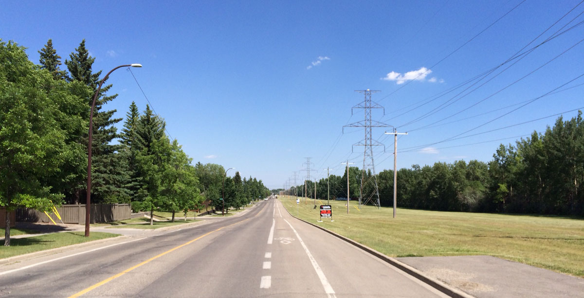
When Lakeview was first being planned in the late 1950s, 66th avenue SW was envisioned as a large parkway route; the existing power lines were to run down the middle of a median with roads on either side of the utility corridor, servicing both sides of the community.15 By the time work began on the subdivision in 1960, the plans had been altered into what we see today: 66th avenue SW was built as a single four-lane road, running north of the utility corridor across the entire 1.6km width of the community.
Final Call for All Flights
In the mid 1960s, with the Sarcee Barracks long since opened and construction of Lakeview in full swing, another significant change was taking place; the former training school airport (by then called RCAF Station Lincoln Park) was decommissioned by the Military. After the airport was closed, portions of the land occupied by the old triangular runway became the new home of Mount Royal College, and the days of hosting take-offs and landings were over.16
Despite this closure, the transmission line remained in its relocated position, providing clear airspace for an airport that no longer existed.
Return of the Land
Sarcee Barracks, later renamed Harvey Barracks, was in operation for over 40 years, and throughout that time the transmission line remained diagonally located across the land. In the early 1980s the Tsuut’ina Nation filed suit against the Federal government, seeking the return of the former northeast corner of the reserve.17
In 1991 the Canadian government agreed to return the Harvey Barracks land to the Tsuut’ina Nation. A new lease was created at that time that would allow for the barracks to remain on the land for decades to come,18 however the Military went on to close the base just a few years later in 1997. When the base was closed, years of unexploded ordnance clearance of the land followed, and in 2002 the Nation regained both ownership and occupation of the land for the first time since the First World War.
One problem with the recovery of the land was that it was returned burdened with a number of utilities.19 Although the power line easements were granted when the land was still owned by the Nation prior to the 1952 sale, Tsuut’ina Nation members had not approved of the use of their land in this way, nor were they formally consulted in the disposition of these rights.
The presence of the transmission lines was not simply an inconvenience, but had a tangible impact to the Nation; for decades the Tsuut’ina had recognized the commercial value of the northeast corner of the reserve, and had been working on plans for the commercial development of the land since it had been returned by the Military. The power lines cut directly through the centre of the developable portion of this land, and could present a significant physical and aesthetic obstacle to any future development reaching its full potential.
Though the transmission lines had cut through this land for over half a century, a mechanism for ensuring their removal was close at hand.
The Ring Road Deal was About More Than Just a Road
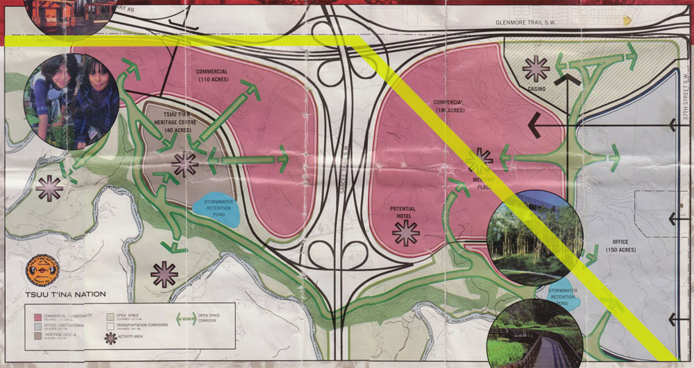
The City of Calgary and the Province of Alberta had for decades wanted to build a freeway on certain portions of the Tsuut’ina Nation’s land, including the northeast corner of the reserve. In 2004, the most recent negotiations began to acquire a corridor for the Southwest Calgary Ring Road, and Alberta’s desire to obtain land for a provincial highway became an opportunity for the Nation to right some historic wrongs.
After an initial draft agreement failed a referendum of Nation members in 2009, a new deal was crafted in 2013. This new ring road agreement covered not only the purchase and transfer of the ring road corridor, but it also contained a number of clauses that pertained to the removal of utilities located on the northeast corner of the reserve.20

In addition to the land required for the ring road itself, the agreement included additional land in order to widen Glenmore Trail along the northern edge of the reserve. This expanded corridor, combined with language in the agreement that compelled the Province to remove the existing lines from reserve land, meant that the stage was set for the line relocation.
AltaLink Begins to Move
Within months of the approval of the ring road deal, formal discussions began over the relocation project, which includes related transmission line work near Sarcee trail. The cost of the entire project was estimated at $95million, and is being covered by Alberta Transportation as part of the wider ring road project.21
While the line through the reserve is owned by TransAlta (the renamed Calgary Power Ltd.), AltaLink was tasked with constructing the replacement transmission line, and will own and operate the new line once constructed.
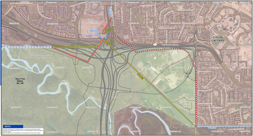
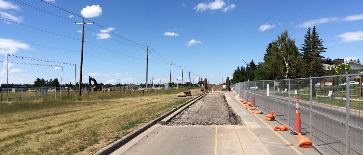
AltaLink drafted a plan for the new segment of the power line to head west of Sarcee Trail along the Province’s newly widened Glenmore Trail corridor until just past the Grey Eagle casino, at which point the line would head south along the City’s 37th street SW right-of-way. The new segment of this line was planned to be buried rather than using elevated wires on towers or poles.22
When the buried line reaches the existing transmission corridor at the intersection of 37th street SW and 66th avenue SW in Lakeview, two new ‘riser’ structures were envisioned to connect the underground wires to the existing above-ground towers.
This seemingly simple plan would not go unnoticed by certain local residents, and a fight over the project emerged.
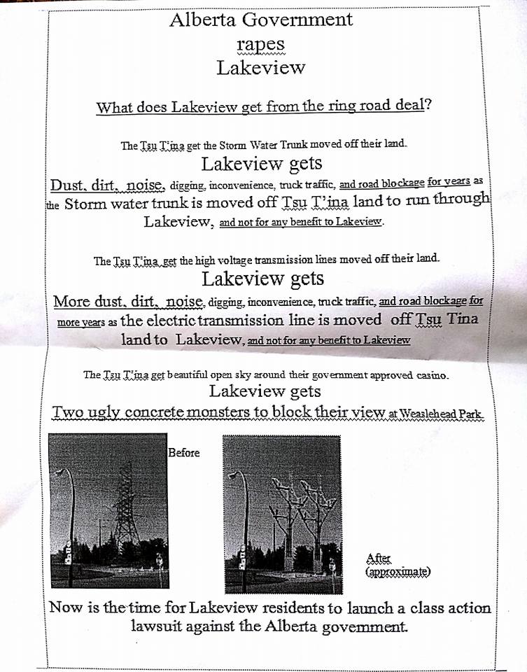
In late 2015 an anonymous flyer was distributed to homes on 37th Street SW which likened the proposed utility relocation to sexual violence and called for a lawsuit to be filed against the Province. Soon, seven individuals who lived on 37th Street SW formed a residents group in order to fight the application made to the Alberta Utilities Commission for the new line.
Calling themselves the Lakeview Concerned Residents, the group listed a number of issues they had with the project, including concerns over ‘misleading’ information given to residents, visual impacts, electric and magnetic field (EMF) levels, concerns about heat from the buried line melting snow, construction impeding access to the Weaselhead and Glenmore parks, and impacts on property value. An apparently significant issue for the group was the lack of an investigation of alternative routes on AltaLink’s part, and the residents suggested different alignments for the relocated line. One suggestion was for the line to instead follow the old 50th avenue corridor from Sarcee trail to reconnect with the power lines near Sandy Beach park; an apparently unwitting request to return to the original 1924 route.24
Despite the residents group spending a reported $95,000 on legal fees to counter the proposed work, the AUC ultimately ruled in favour of AltaLink’s application.25 This approval meant that the relevant permits were issued in November of 2016, and construction was cleared to begin.
Hurdles cleared
Construction of the relocated underground lines are now well underway; it began near Sarcee Trail in January of 2017 and has now reached 37th street SW.
Construction on the entire project is set to be completed in the summer of 2018, at which time the old transmission line across the Tsuut’ina Nation reserve will be permanently disconnected from Alberta’s power grid. Once the old towers are salvaged, the majority of the Tsuut’ina Nation-owned land at the northeast corner of the reserve will be unencumbered by electrical utilities, and the 90+ year story of the relationship between the lines and the reserve will come to an end.
With thanks to Dave Lee at AltaLink, and to Dave Birrell at the Bomber Command Museum of Canada.
Current information on AltaLink’s Southwest Calgary Ring Road Transmission Project can be found here: www.altalink.ca/projects/view/149/southwest-calgary-ring-road-transmission-project
Sources:
1) ‘Plan showing land required for right-of-way of Transmission Line No. 3 from Jumping Pound to Calgary through Townships 23 & 24 in Ranges 1, 2, 3 & 4 all west of the fifth meridian and through the Sarcee Indian Reserve’ R.V. Heathcott. Calgary Power Company Ltd. Alberta Land Registry Plan RW176. 1924.
2) ‘Plan showing land required for right of way of Transmission Line No. 3 in the Sarcee Indian Reserve through Tp.23 Rg.2 W5th Mer.’ R.V. Heathcott. Calgary Power Company Ltd. Canada Lands Survey Plan IRR 2059. 1924.
3) Order in Council of the Privy Council P.C. 1563. 16th September 1924.
4) Agreement for an easement between His Majesty, King George V in right of Canada and the Calgary Power Company Limited. December 8 1924. Attached to P.C. 1563.
5) ‘Empire’s Airmen Stand Together As Currie Field Officially Opened’ Calgary Herald, October 28, 1940.
6) Order in Council of the Privy Council P.C. 2532. 24th May 1951.
7) Letter from Deputy Minister, Indian Affairs Branch Department of Mines & Minerals to Acting Deputy Minister (Air Service) Department of National Defence. June 16 1940. Department of Northern Affairs & Northern Development Document X10560D.
8) Sarcee Band Council Resolution June 19 1940. Department of Northern Affairs & Northern Development Document X020620.
9) ‘Plan showing survey of Transmission Line from N.B’d’y of Sarcee Reserve near S.E. Corner Sec. 2-Tp.24 – Rge.2 – W. of 5th M. to Near N.E. Corner Sec. 32 – Tp.23 – Rge.1 – W. of 5th M.’ R.V. Heathcott. Calgary Power Company Ltd. Alberta Land Registry Plan RW411. 1940.
10) Indenture between His Majesty, King George the Sixth in right of Canada and Calgary Power Limited. May 24 1951. Attached to P.C. 2532.
11) Order in Council of the Privy Council P.C. 1575 1/2. 21st March 1952.
12) ‘A Look At Calgary’s Defence Establishments’ Barry Griffiths. Calgary Herald. November 9 1957.
13) ‘History’ AltaLink. http://www.altalink.ca/about/history.cfm. Retrieved July 3 2017.
14) Photo 11700, University of Calgary Alberta Air Photo Collection. Photographic Survey Corporation Ltd. 1956.
15) Minutes of Thoroughfare Committee Meeting, March 30 1959. The City of Calgary Corporate Records, Archives. Board of Commissioners. S. IV Box 126, f. Thoroughfares. 1959.
16) ‘Changing Skies’ Mount Royal University. www.mtroyal.ca/Summit/aviation.htm Retrieved July 2 2017.
17) ‘Sarcees File Caveat On Calgary Military Camp’ Kainai News. July #1, 1981.
18) ‘Band wins back reserve land from military’ Wendy Dudley. Calgary Herald. April 2 1992.
19) Order in Council of the Privy Council P.C. 1992-1731. 27 July 1992.
20) Final Agreement between Tsuu T’ina Nation and Her Majesty the Queen in right of Alberta, November 27 2013. Interestingly, the previously-rejected 2009 draft deal did not address the issue of unwanted utility corridors on reserve land, and the transmission line relocation clauses were added to the agreement following the recommencement of renegotiations in 2011.
21) Decision 20986-D01-2016, AltaLink Management Ltd. Southwest Calgary Ring Road Project Transmission Project. August 31, 2016.
22) ‘Electric system improvements and you’ newsletter. AltaLink, September 2015.
23) Alberta Utilities Commission Decision 20986-D01-2016, AltaLink Management Ltd. Southwest Calgary Ring Road Project Transmission Project. August 31, 2016.
24) Alberta Utilities Commission Decision 21818-D01-2016, AltaLink Management Ltd. Southwest Calgary Ring Road Project Transmission Project. Costs Award. November 4, 2016.
Following the initial proceedings, the Lakeview Concerned Residents group applied for its legal costs to be covered as provided for as a ‘local intervener’ under the Hydro and Electric Energy Act. The Alberta Utilities Commission awarded a portion of the costs to the resident’s group, but believed that the fees claimed were ‘excessive’. The AUC required AltaLink to cover 40%, or about $40,000, of the group’s legal fees.

Thanks Jesse for a most informative backgrounder. Puzzled that the lines are being buried under sthbound 37th St. Was there not enough room on the grass beside the stormwater trunk?
I believe the original plan did have the lines largely under the grass portion of the 37th street corridor, but that was altered over the last year. I think the new storm trunk likely limited where the power lines could go.
Jesse, again your information is so interesting. This power line story, that of the UXO’s, and really the whole blog are really great. You should publish a book.
Thanks so much! I love this history, and I’m so gratified to know that there are others who feel the same! One day I hope to be able to make more of my research.
Hello! Came to your interesting article from SSP’s Stoney Trail forum. One correction to suggest: in the picture of 66th Ave, isn’t the view looking EAST? If the road is north of the power line, then for sure that pic is looking east…
Interesting read – thanks!
Thanks for catching that!