
The opening of the southeast Calgary ring road in November marked not only the completion of over three years of construction, but also of the fulfillment of a goal first set out by the Province of Alberta nearly 60 years earlier.
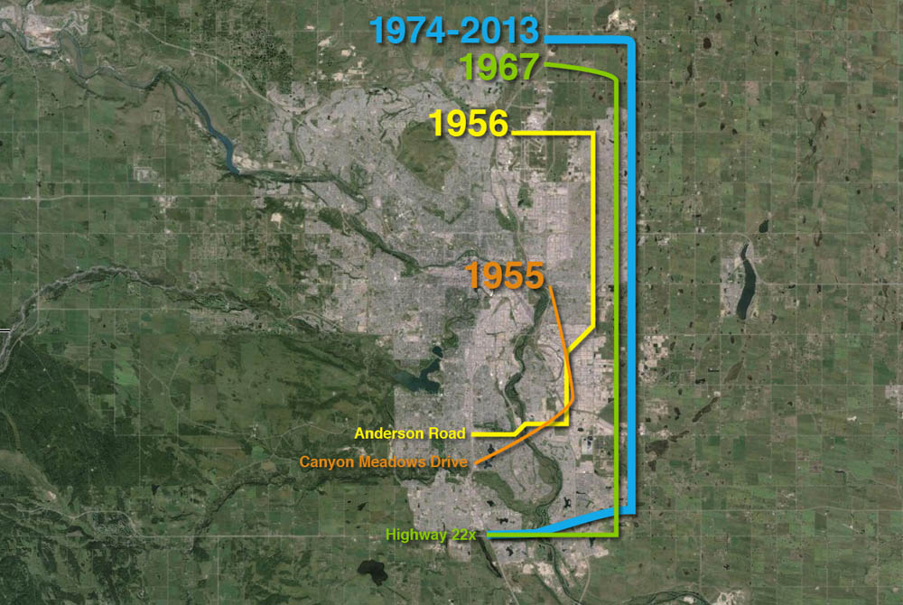 (A progression of bypass proposals for East Calgary is shown above)
Early Bypasses
In the 1950s, when bypass plans were first considered for the Calgary area, the city’s main arterial roads radiated from the core, and the primary bridges over the City’s rivers were largely located downtown. To access the industrial southeast, residents living in the new suburbs of the northwest and southwest would have to drive through or near the increasingly congested core. In order to allow drivers not bound for downtown to bypass central Calgary, and in order to allow long-range travelers to connect between major highways without adding to the congestion of the city, several bypass roads would be proposed that would avoid the city centre. These early bypass plans would include such a facility along the city’s southeastern edge.
The earliest public announcement of a southeast bypass road considered for Calgary dates back to 1955, to the same announcement that also heralded the origins of Calgary’s southwest ring road. On Friday November 18 1955, Provincial Highways Minister Gordon Taylor outlined the Province’s plans for road development in the Calgary area, and included the basic outlines for a bypass road that would skirt southeast Calgary. There was a desire to connect the east side of Highway 1 (then 17th avenue SE) with the south side of Highway 2 (then the Macleod trail) in a way that allowed drivers to avoid having to enter the busy centre of Calgary, and the proposed road would allow for this direct movement.
Originating near what is now the interchange of Deerfoot trail and 17th avenue SE just west of Forest Lawn, the Provincial bypass road was intended to head south through Ogden, and then head in a south-westerly direction to connect with Macleod trail south of Anderson Road. This road was planned largely outside of the City limits, through what was then rural farmland.
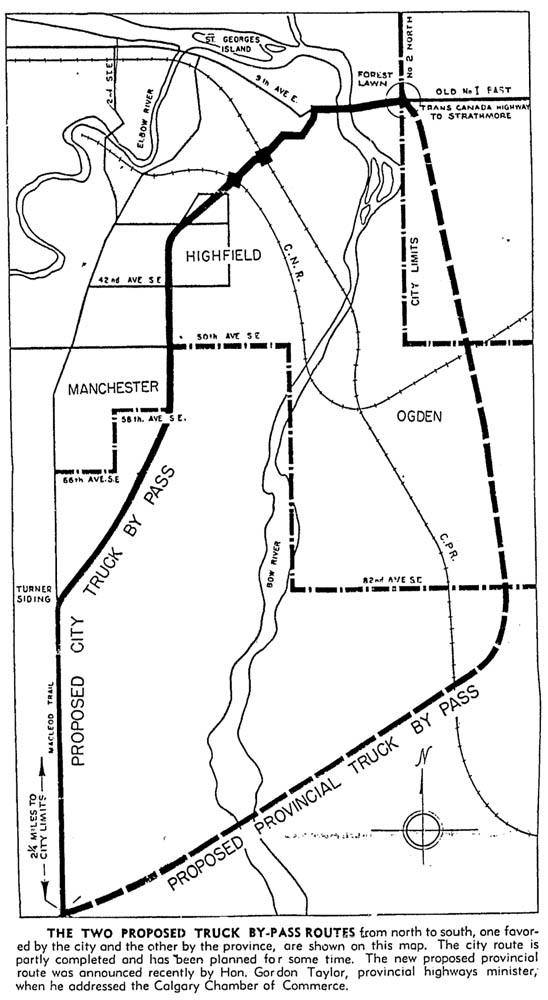 Though Calgary’s mayor, Don Mackay, was in favour of a bypass road, he felt that the Province’s planned road was located too far out of the city to have any immediate benefits to the residents and businesses of southeast Calgary. Mackay instead favoured a road that the City had already had begun building; one which was poised to serve the City’s growing industrial areas. The City’s road originated at the same location as the Provincial proposal and headed along the present Blackfoot trail to Glenmore trail, where the City wanted the Province to extend the road in a southwesterly direction to Macleod trail at Heritage Drive.
Where the Province’s road would have acted as a true rural highway, the City’s road would be more of an urban connector. Despite, or perhaps because of, the differing priorities and functions that both roads served, both bypass routes would survive into the next major planning project, that of Calgary’s first ring road plans.
A ring road is born
In 1956, the City of Calgary formalized it’s first ever ring road plans. Though aspects of the plan had been in the works for several years, the 1956 plans marked the first comprehensive, integrated vision of a ring road for Calgary. The scheme detailed three concentric bypass rings: An inner ring around the downtown core, an intermediate ring around much of the existing city, and an outer ring that was located entirely outside of the city limits, which would encircle not only the city but also decades of future growth.
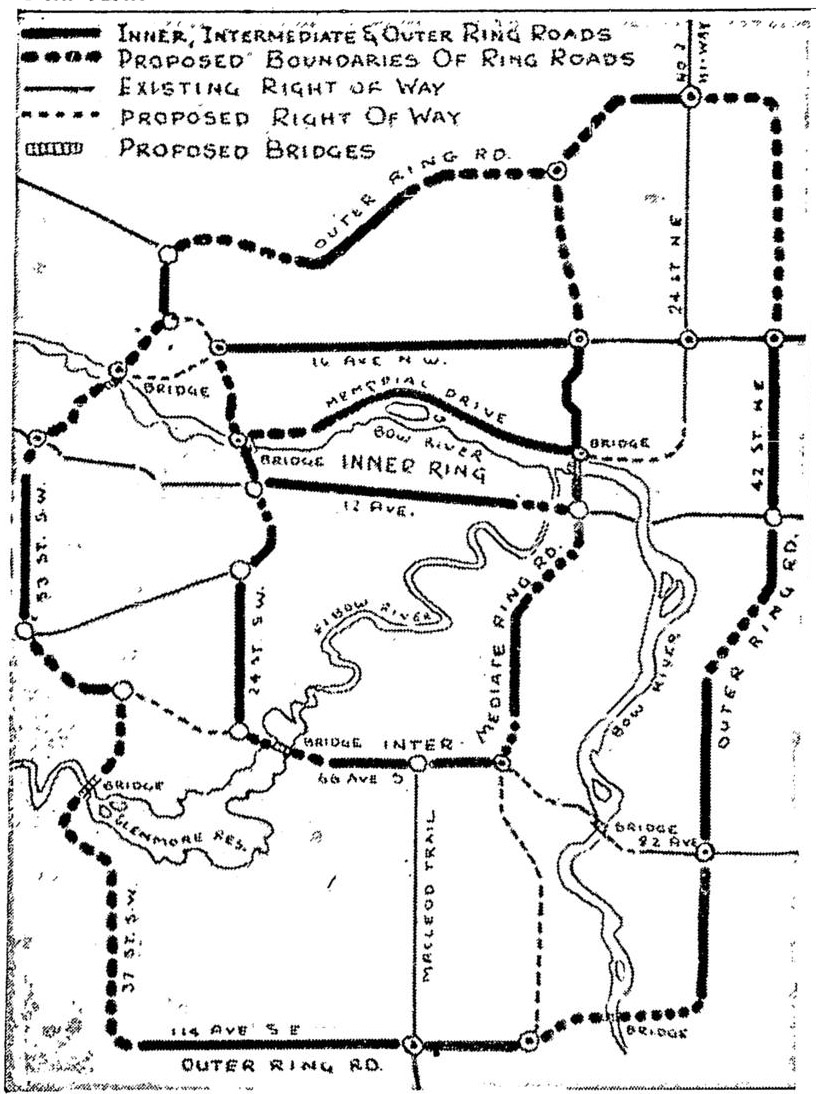 In the east, the plans retained the City’s Blackfoot trail route as part of the intermediate ring. The Province’s route meanwhile would be modified and integrated into the second stage of the bypass network, the outer ring, which would provide a true highway bypass around the city. The modified Provincial road was straightened, and pushed further east than previously noted; it now began at the intersection of 17th avenue SE and 52nd street SE, where it headed south to the CN train tracks. The road followed the tracks in a south-westerly direction to the 32nd street SE/Barlow trail corridor, where it headed south to 114th avenue/Anderson Road. From there the road headed east across the Bow river to connect with Macleod trail.
Though these mid-1950s ring road concepts showed the outer ring as an integrated high-capacity facility, these plans would soon change. Longer-range planning would be eschewed in favour of practicality.
Approved Planning
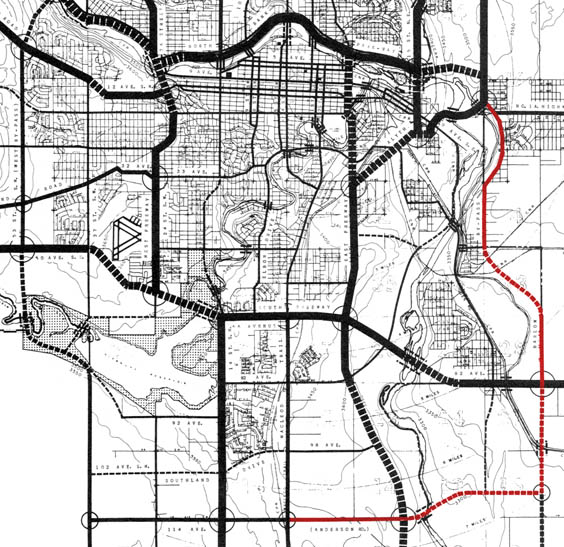
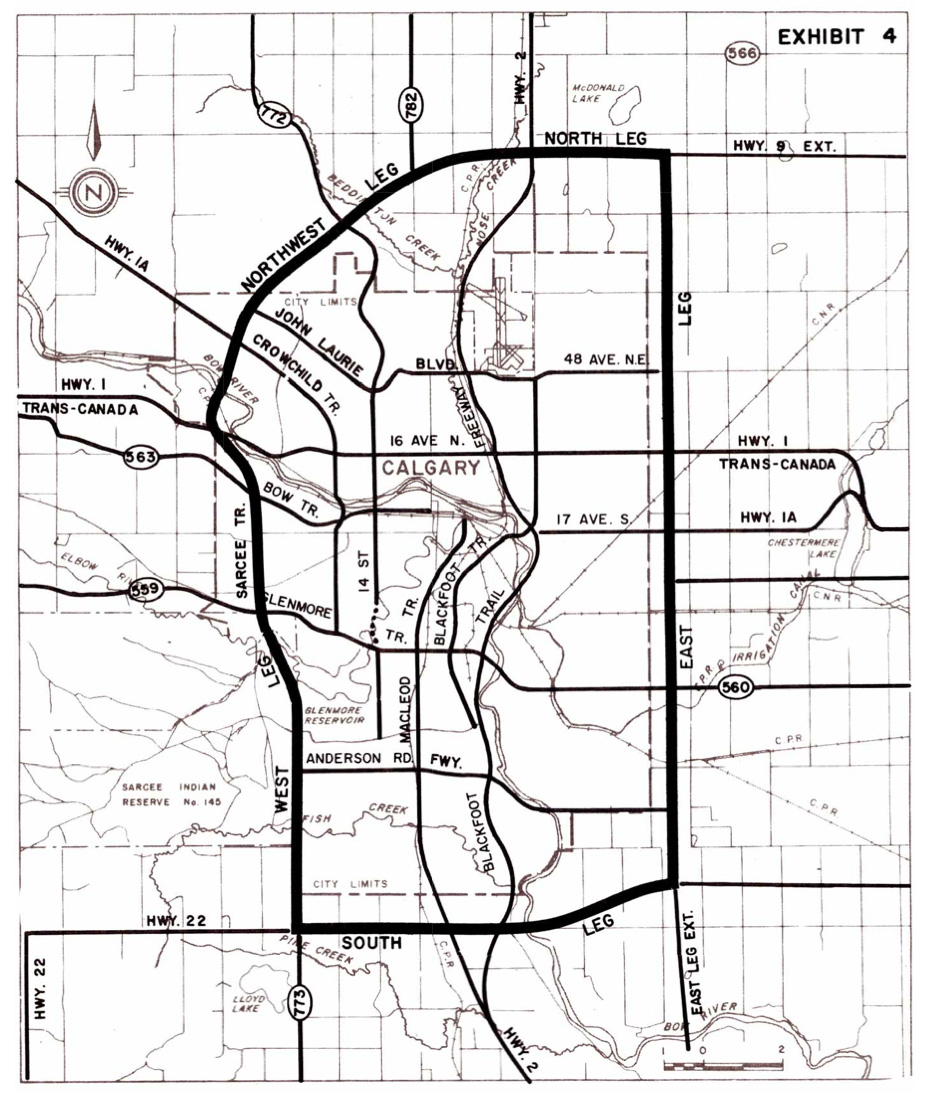
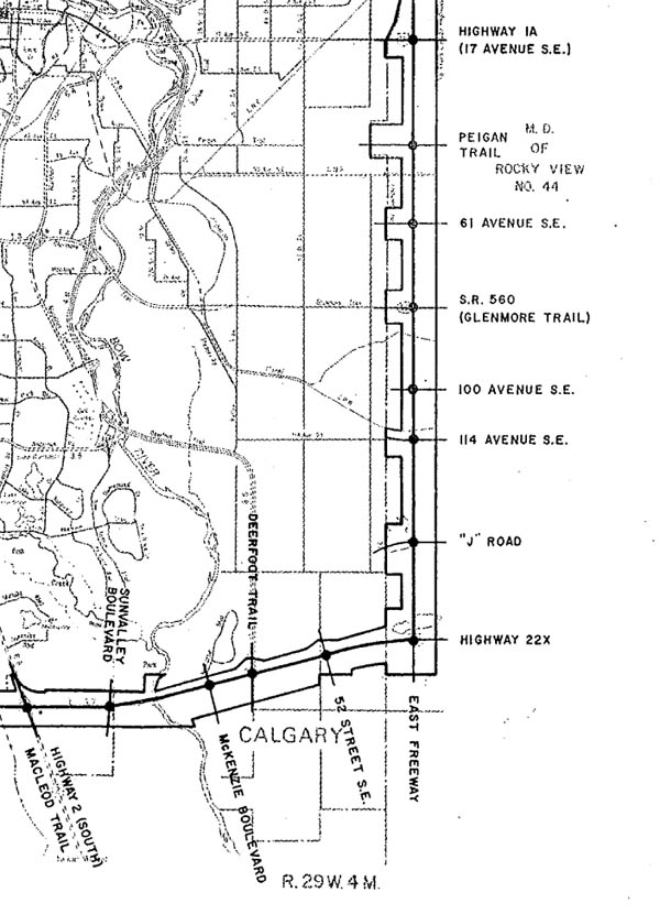
In 1959 the City of Calgary approved its first ever comprehensive transportation plan, the Calgary Metropolitan Area Transportation Plan. Following several years of traffic and parking studies, including an expansive survey of Calgary residents, a comprehensive transportation report was produced and approved by the City that included a 20-year plan for road infrastructure. (The southern portion of which is shown below)
 Beyond it’s unprecedented scope, which included a study of driver ‘desire lines’, downtown parking and the primary road network, the report is notable for its position of largely rejecting rural bypass roads around the city.
The report summarized this matter by stating that only a single movement, from Highway 2 in the north to Highway 2 in the south, had the demand required to consider an expressway-standard bypass. The demand for other bypass trips between Provincial highways “even if multiplied by four or five” did not warrant the construction of such a road. Though some bypass routes were retained in the plans, at times over voiced concern by the committee members responsible for creating the plan, the integrated outer ring road concept was eroded and the circular symmetry found in earlier plans was lost. Part of this hesitancy to endorse bypass routes, beyond the perceived lack of need, was a desire to plan for an attainable and affordable transportation network.
“In developing this (road) system, it must be recognized that there will be a definite limit to the funds available for construction of new road facilities. It will be far better to devise and adopt a somewhat limited, but adequate, system, which is within the community’s ability to pay for its construction than to plan a more elaborate system, build part of it, and then find the cost of completion to be beyond the available money.”
Due the frugality of the plan, an outer southeast bypass route was maintained to some degree only by following a combination of what was then called the Barlow Bypass and Anderson Road (shown in red on the map above).
The City’s original Blackfoot trail bypass route, then called the “East Freeway”, would be retained in the plans as the primary north-south freeway for the city, and would serve as a precursor to today’s Deerfoot trail.
Further Refinement
Over the next decade an a half, the route for the eastern and southern bypass roads would undergo many modifications. A series of plans and studies looking at Calgary’s road network provided an evolving and expanding plan for many of the city’s major roads, and included routes that would eventually lead to what would become the southeast ring road.
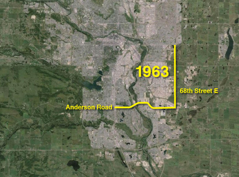 The first major revision of the City’s transportation plans was undertaken as part of the 1963 Calgary master plan. Though a modified Barlow trail that mirrored the Province’s earlier bypass route would continue to play a role in the transportation network in southeast Calgary, a new expressway was planned further east which was to become an outer southeast bypass route. Known simply as 68th street, this corridor rejected the curves and detours of previous routes by traveling due north, from Anderson road to 80th avenue NE and beyond.
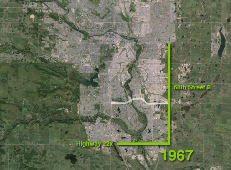 In 1967, Calgary continued to refine its long-range road planning with the creation of CALTS (the Calgary Transportation Study). This study not only maintained a southeast bypass route, but also began to integrate separate bypass routes in other quadrants of the city back into a more cohesive ring road plan, something that had previously been sidelined. This plan abandoned the Anderson road corridor previously earmarked for the southern leg of the road in favour of the Highway 22x corridor south of Fish Creek, and would mark the first time that a portion of the southeast ring road would be planned where it would eventually be constructed. The east leg retained the 68th street E corridor found in the previous plan.
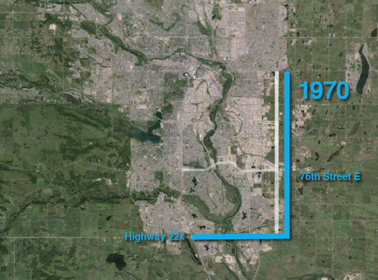 In 1970 the Province created a plan in order to merge the City’s bypass road network as envisioned in CALTS with an earlier Provincial study of Calgary-area highways completed in 1966. The resulting Calgary Area Study dealt significantly with the ring road, and in creating this plan, the Province agreed to a City request to move the eastern portion of this road farther east. The City had noted that their original routing of this portion of the road along 68th street was too close to the newly planned Deerfoot trail, and that the first freeway east of Deerfoot trail should be located outside of the city limits. While the Provincial study kept the road situated along Highway 22x in the south, the eastern leg was pushed one-half mile to the east onto the 76th street corridor.
Apart from a small alteration to the southeast corner of the road in a subsequent study, the route of the southeast portion of the ring road was largely set out as we know it today.
Finalized Route
Despite the many road plans that had been created in the twenty years that preceded it, it wasn’t until 1974 that a dedicated and detailed feasibility study was undertaken to look at the practicalities of building the ring road. The Province’s Calgary Parkway Ring study built on the earlier Calgary Area Study to begin to answer some of the basic questions regarding the benefits such a facility would bring to the City, including if such a road was needed at all.
The overall route detailed in the 1974 study was largely unchanged from the study created 4 years earlier. The only notable alteration was that the southeast corner of the ring was moved one mile north in order to connect with the planned Highway 901 to the east of the City.
 Like the City’s transportation study produced 15 years earlier, the Provincial report does not see the immediate benefits of the bypass function of the road, citing low demand for such movements.
In assessing the case for the southeast portion of this road, the Parkway Ring report was clear that the plans were considered long-range, and that the southeast portion of the road was not needed at that time. The report states in part “…(the southeast portion) is too far removed from the concentrated urban development to fulfill the ring road functions of serving inter and intra-urban traffic. Because of… the projected low utility, it is recommended that the right-of-way be protected on the basis of the regional road requirements and the decision with regard to Ring Road requirements be deferred…”
Two years later, in 1976, the Province of Alberta took it’s first practical steps in creating the Calgary ring road, by enacting legislation to protect the ring road corridor. The development of the ring road would still be many years away, but land that would eventually be required for construction would be protected by a ‘Restricted Development Area’. This meant that land owners in that area required Provincial permission to build on the land, and ensured that the Province would be able to keep the corridor clear of developments that might impede the road until the land could be purchased.
Getting into the specifics
In 1979 the Province developed functional plans for the Calgary ring road for the first time, and moved the planning from high-level route studies into more functional plans, which included for the first time interchange locations. Following a reassessment of the road in 1985, the southeast leg contained the following interchanges: 17th avenue SE, Peigan trail, 61st avenue SE, Glenmore trail, 100th avenue SE, 114th avenue SE, 130th avenue, Highway 901/22x, 52nd street SE, Deerfoot trail, Mackenzie Boulevard (Cranston Boulevard), Sun Valley Boulevard and Macleod trail.
 It was noted at this time that the right-of-way for a half-diamond interchange was set aside in the plans at Mackenzie Boulevard (Cranston Boulevard), allowing for a limited-movement interchange at this location.
Though the design had been completed to a functional standard, several obstacles remained to building the southeast portion of the road. These included low demand for such a facility, a lack of detailed plans for the road and the lack of a budget; all of which would be addressed over the following 25 years.
Modern Planning
In July of 2002, following years of residential and industrial growth in Calgary’s Southeast quadrant, the Province of Alberta announced that it was retaining a consulting engineering firm to design detailed plans of the eastern portion of the Calgary ring road. Beginning at Deerfoot trail in the north and winding its way south to its intersection with Macleod trail in the south, EarthTech was charged with designing every lane, ramp, bridge and interchange along the 46km corridor of the ‘East Freeway’. “With the increase in Calgary’s population and where employment sectors are located, we need to do a study to address revised traffic needs.” Alberta Transportation spokeswoman Cheryl MacKenzie stated at the announcement of the study.
The announcement was welcomed by then-rookie alderman Ric McIver, whose growing ward 12 would be bordered and serviced by the southeast ring road. McIver stated “This is really good news. It says to me that (the Province) want to build the thing.”
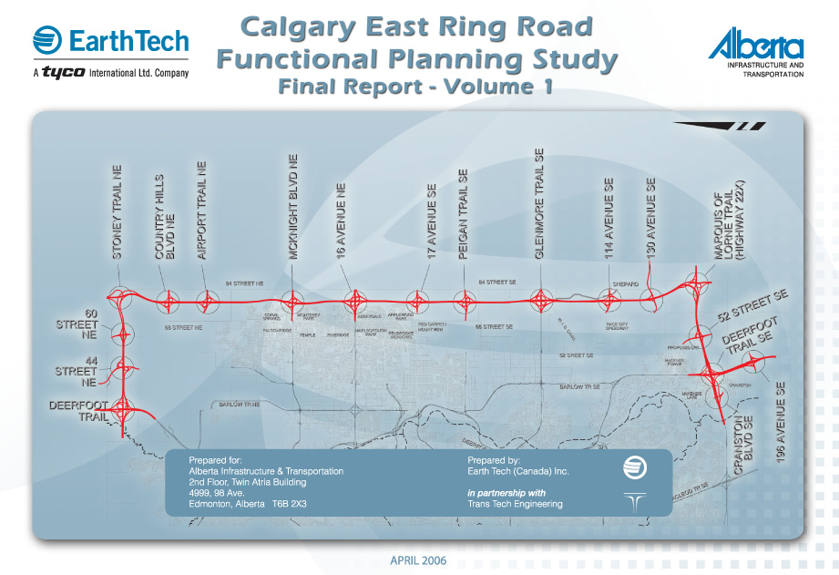 The detailed study of the East Freeway, including a small portion of Deerfoot trail south of the ring road, lasted for four years and plans were completed in 2006.
Construction of the South East Stoney Trail
Development of the ring road, known officially as Stoney trail, had begun in the mid 1990s with the construction of a portion of the northwest leg. Following the extension of the northwest section and the construction of the entire northeast leg in the 2000s, the third portion of the road to be considered for construction was the southeast leg.
On May 19 2009 the Province opened the Request for Proposal process for the construction and maintenance of the southeast ring road, and on March 30 2010 a Public-Private Partnership (P3) contract was awarded to the Chinook Road Partnership, a group of construction companies led by SNC Lavalin Inc. The road had been given the name of Stoney trail along with the rest of the ring road, and the new venture was referred to as the South East Stoney Trail (SEST) project. By June of 2010, construction of the road had begun.
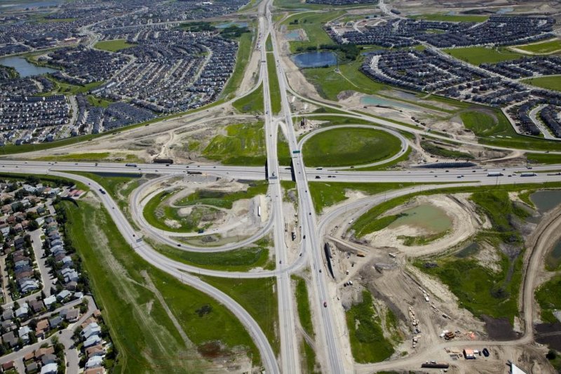 (The Stoney trail and Deerfoot trail interchange under construction, July 2012, photo courtesy Chinook Roads Partnership)
The 33-year P3 contract was valued at $769 million in 2010 dollars, or $1.226 billion unadjusted, with the government of Alberta contributing $232 million and the Federal Government contributing $100 million towards the construction phase. Monthly payments of about $2.1 million would be paid to the Chinook Road Partnership over the 30 years following completion, both to finance construction and to pay for the 30 year maintenance contract built into the P3 agreement. The Alberta Government estimated that the same project would have cost $1.8 billion in 2010 dollars and would have taken two years longer to build if it was delivered by traditional, non-P3, means.
In addition to the southeast portion of the ring road, the contract also included the construction and maintenance of a 12km portion of Deerfoot trail; south of Stoney trail to the interchange with Highway 2A just north of Okotoks.
The Open Road
On November 22 2013, after 3.5 years of construction, the southeast portion of the Calgary ring road was officially opened. This opening, however, was not without issues. The agreement between the Province and the Chinook Roads Partnership called for an October 1 2013 ‘Traffic Availability’ date, putting the opening of the project 52 days behind schedule.
In order to encourage on-time completion, the agreement contained clauses to motivate the contractor to finish on time, and section 9.6 of the P3 contract specifies how penalties are levied against the contractor for failing to open the road on schedule. Rather than a fine, the agreement simply states that the contractor will not be paid their capital or maintenance payments for the duration of the delayed opening. The penalty is not specified in the contract as a fixed amount because the monthly payments for the road are variable, based in part on inflation and traffic volume, and the 52 day delay meant a penalty figure of $3,657,731.79 as confirmed by Alberta Transportation.
The Last Remaining Link
With the completion of the South East Stoney Trail Project only the southwest portion of the remains outstanding as the final link of Calgary’s ring road, though progress here too is being made. Earlier this year, the Tsuut’ina voted to approve a land deal that would allow the southwest portion of the ring road to go through what is now their reserve, and former Transportation Minister Ric McIver has stated that the entire road would be looked at for completion before the seven-year deadline contained in the 2013 deal. With these milestones reached, there is every possibility that Calgary will have a completed ring road before the end of the decade.
