
The 2013 Ring Road Agreement between the Tsuut’ina Nation and the Province of Alberta was announced on Friday October 25 2013, marking the conclusion of the latest round of negotiations. A new deal, which was crucial in addressing concerns regarding the previous agreement from 2009, contains new compensation levels, new guarantees, and a slightly modified design for the road.
UPDATE JULY 2015: The Federal Government approved the addition to the Tsuut’ina reserve and the transfer of the road corridor to the Province in May 2015. Click here for all of the details.
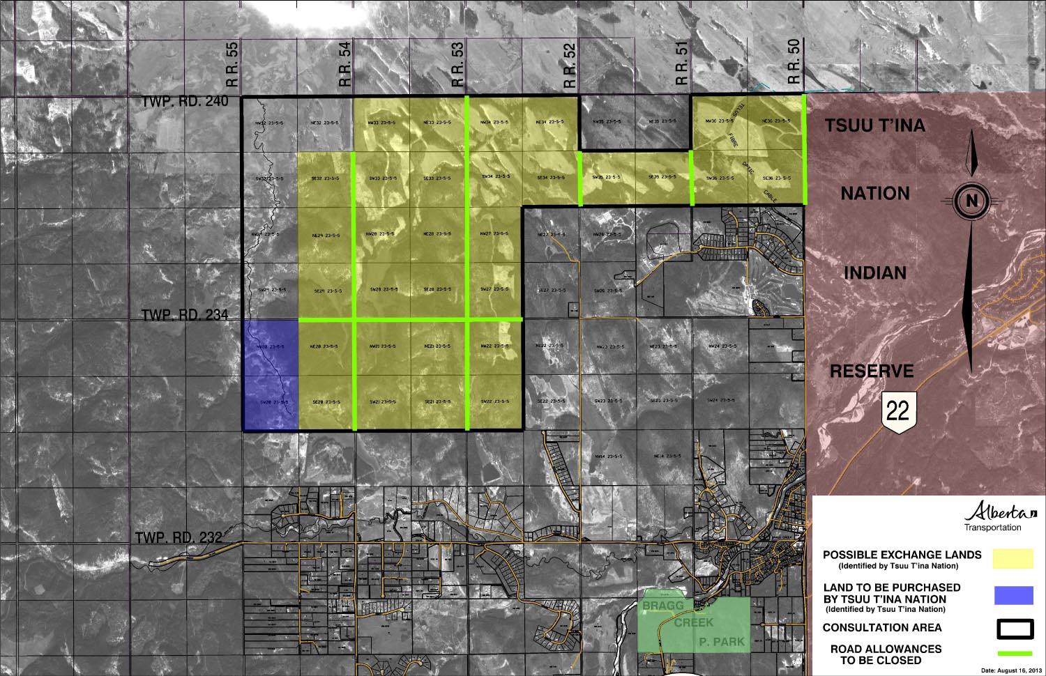
The Nation will receive from the Province:
• Guaranteed 5338.1 acres of crown land located to the west of the current reserve, which will be converted into reserve status, valued at $44,420,683.50 (See lands map below). The total land figure includes 5,018.1 acres of crown lands provided as compensation in the agreement (Shown in yellow in the map below), as well as an additional 320 acres of crown land that the Nation will purchase for $1,643,000 (Shown in blue in the map below).
• $275,000,000 in cash
• $65,643,900 additional funds to be used for the relocation and reconstruction costs for homes, businesses and roads currently located in the path of the road.
The Province will receive from the Nation:
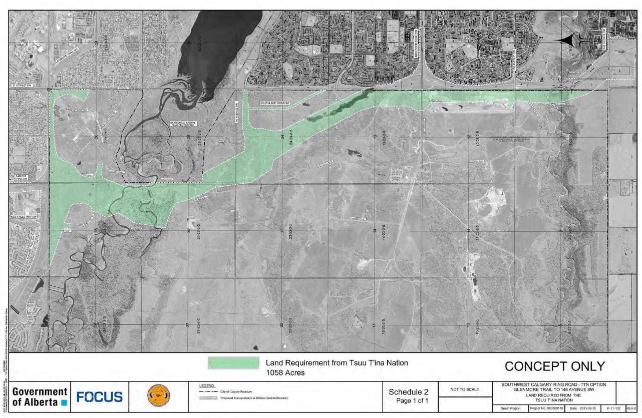
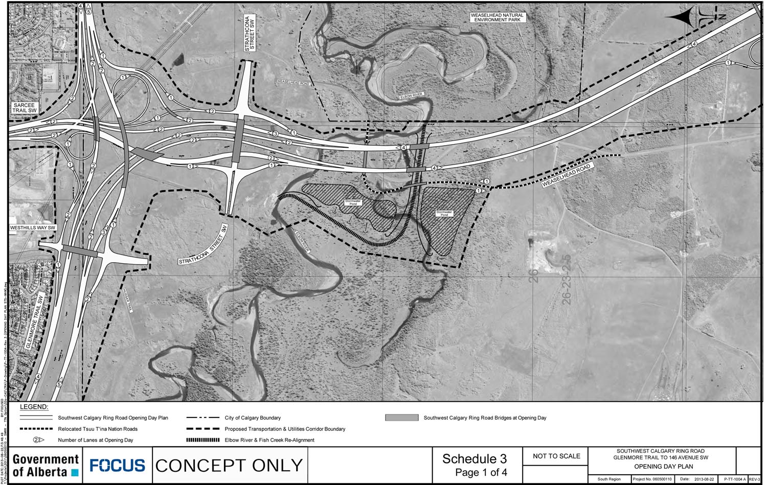
• 1058 acres needed for the Transportation Utility Corridor (TUC) where the ring road would be built (shaded green in the map below)
In addition and apart from this agreement, the plan would see approximately 8 acres from the SW corner of the Weaselhead park purchased by the Province from the City of Calgary, while the existing high-pressure natural gas line and overhead transmission lines that run through the park would be removed from the natural area.
OTHER ASPECTS OF THE DEAL
In addition to the financial compensation and land transfers contained in the agreement, there are other clauses that dictate how the road would be implemented.
The Road
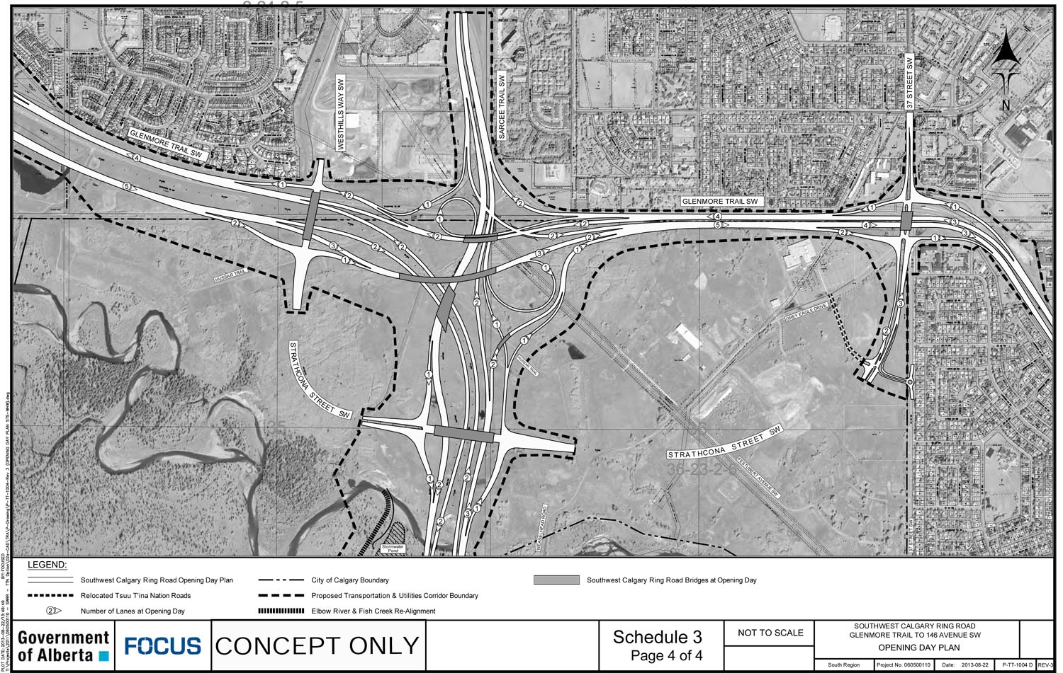
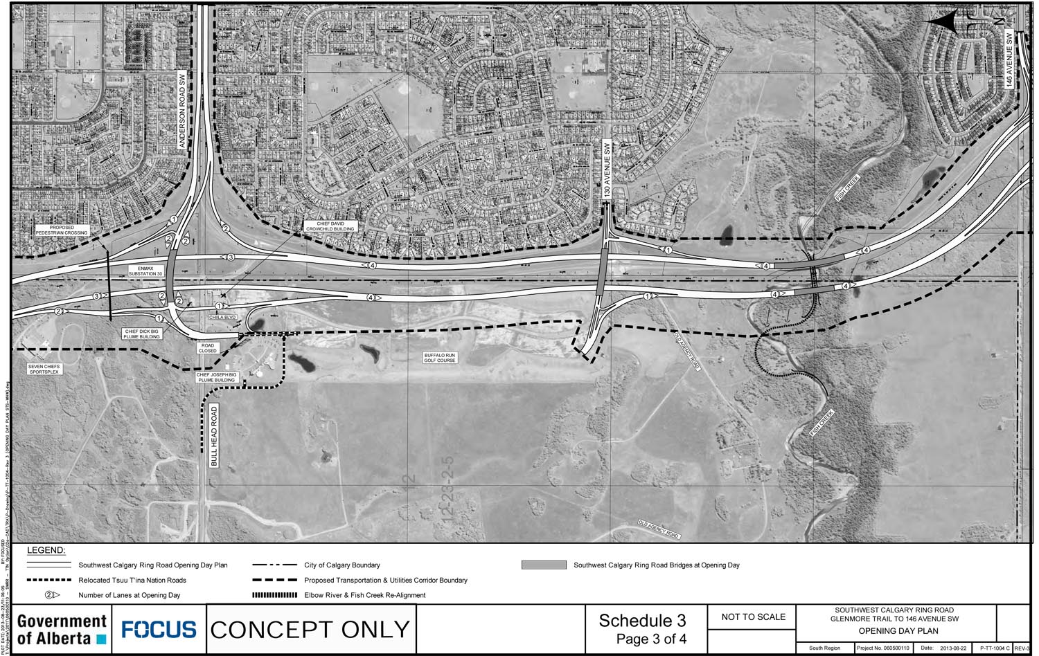
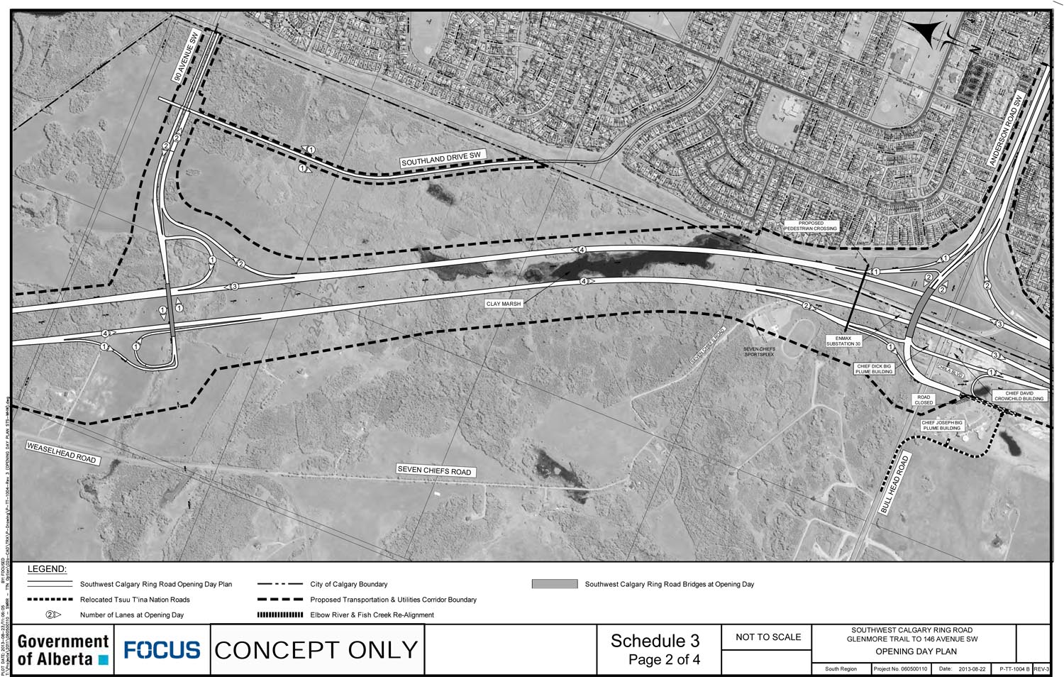
The agreement required the Province to build and maintain the ‘Opening Day’ road plan within seven years of the completion of the land transfers. The design of the road, though conceptual at this stage of the project and will likely be modified to some minor degree by future survey and reassessment work, is largely the same as the 2009 plan. The ‘Opening Day’ plan requires the construction of:
• The ring road as detailed in the map below
• Glenmore Trail between Sarcee Trail and 37th street SW
• 90th avenue SW between the ring road and the current City limits
• Southland Drive between 90th avenue SW and the current City limits
• Interchanges at: 130th avenue SW, Anderson road, 90th avenue SW, Sarcee/Glenmore trails, Strathcona street, Westhills way and the Glenmore trail/37th street SW interchange.
(Click on any of the maps for a higher-resolution version. Original maps are provided at the end of this post.)
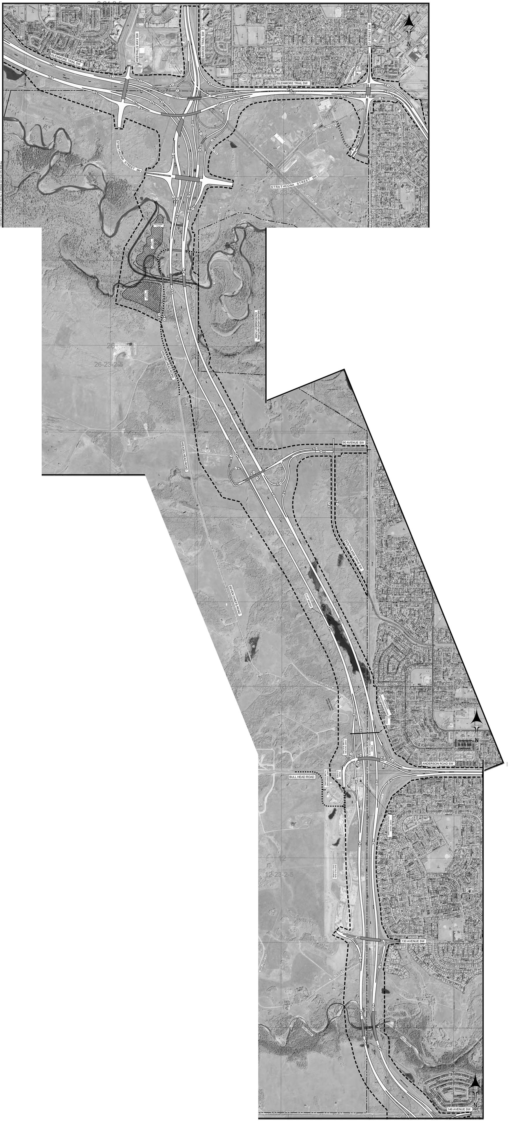
As well as the connections detailed above, an additional four traffic lights will be allowed on Southland drive and a single additional traffic light will be allowed on 90 avenue SW for future access to reserve land along those two roads. The agreement also details an extensive list of traffic ‘movements’ that would be guaranteed and forms a binding part of the agreement.
Releasing Potential Claim Issues
Section VIII of the agreement functions as a release of potential liability for the Province in relation to actions initiated by the Tsuut’ina in Federal Court. These actions, numbers T-364-01 and T-369-01, relate to ‘disputed parcels and interests’. The Nation has agreed to release the Province from any claims or lawsuits, now and in the future, related to the contents of these actions, though the Province is not actually a Party to the actions. The release was requested by the Province, and agreed to by the Nation in consideration of the additional $65.6 million that was included with the compensation for the land, as well as the removal and abandonment of certain utilities, detailed below.
Though full details of these actions are not contained in the agreement, the ‘disputed interests’ stem from legacy infrastructure located on a portion of the Tsuut’ina reserve that was once owned by the military, formerly called the Harvey Barracks and now known as ‘the 940’. The agreement requires the Province to relocate, remove and abandon several utility lines that cross these lands, including electricity transmissions lines, sewer lines and natural gas pipelines. Some of the infrastructure dates back to the 1920s, and in many cases will be removed or abandoned not just from the road corridor, but from Tsuut’ina lands entirely.
The specific ‘disputed parcels’ are not described in the agreement, but there are a number of parcels of land in the former Harvey Barracks and Weaselhead areas that have potentially contentious ownership (and which are unrelated to the recent Glenmore Land Claim Settlement). The actions mentioned in the agreement may or may not relate to these parcels of land, though details will be covered when more information is obtained.
Termination of the Agreement
There are several ways in which the agreement, once signed, can be terminated and for the road corridor to be returned to the Nation:
• Failure to construct the ‘Opening Day’ ring road plan and open the road for traffic within seven years from the date the lands are transferred.
• Failure to provide all of the traffic movements as detailed in the agreement.
• Failure to complete the requirements of the agreement by July 1 2015 (known as the ‘trigger date’) would allow either party to terminate the agreement with 30 days notice in writing. The requirements being: the payment for the corridor by the Province, the transfer of the new lands into reserve status, the payment by the Nation for the additional parcel of new land and the transfer of the road corridor to the Province.
• If neither party terminates the agreement within 30 days of the trigger date, the agreement will terminate automatically if the requirements still have not been met by July 1 2016. (Both the trigger date and this one-year anniversary can be adjusted by mutual agreement)
Burial Sites
The agreement contains a protocol for dealing with the discovery of culturally significant sites and human remains along the road corridor. The protocol, which is being applied to all projects on Tsuut’ina lands going forward, requires appropriate time and suitable courses of action in regards to the assessment and respectful handling of remains, along with appropriate ceremonies by the Nation. Burial sites will be repatriated to the Tsuut’ina reserve at the Province’s expense.
The Weaselhead, the Elbow River and Fish Creek
Not contained directly in the agreement, but certainly part of the road design plan, are direct impacts on the Weaselhead. The new road alignment that forms part of the 2013 agreement encroaches into the Weaselhead park located within the City of Calgary. An area of approximately 8 acres, though potentially as little as 4 acres, from the south west corner of the park would need to be purchased from the City in order to be incorporated into the Transportation Utility Corridor that contains the ring road (shaded in red below).
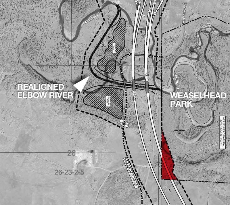
The plans for the ring road project also includes the removal of certain utilities currently located in the Weaselhead area. A high-pressure natural gas line and an overhead power line that currently bisects the Weaselhead park will be removed and relocated to the Transportation Utility Corridor. The current location of these utilities will be allowed to be reclaimed by nature.
In addition, the Elbow River and Fish Creek would be realigned to the west and under the ring road crossing (the Elbow realignment shown in black above), and portions of the riverbanks would potentially be ‘stabilized’ on each waterway.
Lakeview Access
With a widened Glenmore Trail and a new 37th street SW interchange, access to Lakeview is planned to be dramatically altered from the current layout, as seen on the map below.
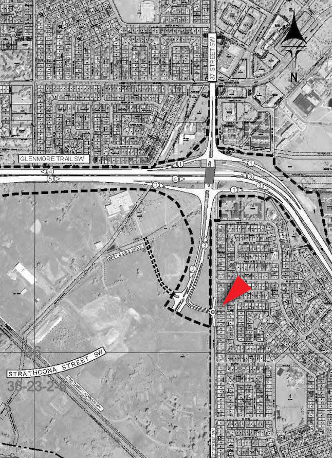
Access will no longer be provided directly from the 37th street SW and Glenmore Trail interchange, but will occur at a new roundabout located on 37th street SW between 54th and 58th avenues SW. This entrance is fed from the new Strathcona street on lands that are currently in the Tsuut’ina reserve.
Affected Tsuut’ina Infrastructure
Beyond the main land and cash compensation contained within the agreement, an additional $65.6 million compensation is provided to the Nation in order to relocate and rebuild affected buildings and infrastructure that is located in the path of the road. These include:
• Nation Housing
• The Sarcee Seven Chiefs Sportsplex
• The Chief David Crowchild Building (Tsuut’ina Nation Gas Stop)
• The Chief Dick Big Plume Building
• Affected Water and Sewer infrastructure
• The Tsuut’ina Nation Culture Museum
• The Buffalo Run Golf Course
• Certain roads on the reserve
Employment of Nation members
As part of the agreement, Minister of Transportation Ric McIver informed Chief Roy Whitney that Alberta Transportation would enter into contracts with suitable Tsuut’ina companies for the following work:
• Vegetation clearing
• Construction of reserve roads identified in the agreement which would be impacted by the construction of the ring road.
• Fencing of the road corridor
• Assistance with clearance of unexploded ordnance in the road corridor
The Province would also enter into contracts to purchase suitable sand and gravel from the Nation at market value for construction of the ring road, as well as the potential rental of construction equipment owned by the Nation or its members.
Original ‘Opening Day’ road plan maps
The entire agreement and maps can be found on Alberta Transportation’s website.
—–
Edited since original publication to add more details contained in the agreement that were not covered initially. Also edited to clarify the portion of the agreement that provided a release from liability from future claims etc.
—–
With thanks to Ann Coffin and Parker Hogan at Alberta Transportation, MLA Linda Johnson and Aziz Merali at Focus.

This is great. Thank you for the detail you put in! I really enjoyed learning more about the exchange and the agreement between the Tsuu T’ina People’s and the province
I’m glad that you found it interesting! Thanks so much for commenting.
Very informative presentation of the historical trace to current status of SWRR. Thank you.
Living on the west edge of Evergreen and looking out to 37th Street. How far from the homes in Evergreen will the road be? Fence to Road? Will a sound barrier wall be erected? Will the road be dug down to reduce the noise?
Alberta Transportation is holding information sessions for the SW Ring Road in October, and the West Ring Road in November. Provincial representatives at these sessions will be able to answer some of the more specific questions regarding these plans. The details are below:
https://calgaryringroad.wordpress.com/2014/10/08/sw-ring-road-information-sessions-announced/
The road plans for the portion closest to Evergreen can be viewed here: https://calgaryringroad.wordpress.com/2014/06/18/ring-road-update-june-2014/
HI there, we are residing in WoodBine and are in close proximity to the 130 Ave over change, can you comment if there are plans to erect a sound barrier, do they plan to leave the dog park? Is there plans for development in the Tsuu Tina golf course ?
Thanks
Earlier noise studies indicated that a barrier would not be needed between Anderson Road and 130th, but that a small length was projected south of 130th.
I can’t comment on the dog park, though the pathway along 37th street is planned to continue to connect between South Glenmore Park and Fish Creek Park.
For more specific information about these issues I would suggest visiting the Province’s SW Ring Road web page at http://www.transportation.alberta.ca/sw-crrgp.htm and sending an email via the link at the bottom.
In terms of future development on the Tsuut’ina reserve; there is indication that development will happen on the former Buffalo Run golf course in due time, though specific plans have not been released by the Nation at this point.
Please would you supply information about pedestrian / bicycle access to the Grey Eagle Casino at Glenmore Trail / 37 st
It’s my understanding that the traffic lights at Grey Eagle Drive and Strathcona Street will be capable of allowing pedestrian movements north, across Strathcona Street towards the Grey Eagle Casino. However, I believe that implementing this this will be dependent on what is on the other side of the street: the Nation’s future commercial developments will have to support pedestrian infrastructure (sidewalks etc.) in order for a crossing to be implemented.