The Railways of the Tsuut’ina reserve

CP_engine

The concept of a Provincial road crossing Tsuut’ina land is a well established one, with two having been built, another shelved, and the Southwest Calgary Ring Road still under negotiations. However, the idea of a railway through southwest Calgary and the reserve might be a little more surprising. Around 100 years ago no less than three Railways were planned to traverse the reserve, lying as it does between Calgary, the southern Alberta coal and oil fields, and the American northwest beyond.

Though the relationship between the Southwest Calgary Ring Road and these railway projects of another century might not be obvious, their stories of infrastructure development, of planned economic prosperity through the ability to transport goods, and of the reserve’s role in potentially providing a path for these projects illustrate a long history of public and private transportation interests in the Tsuut’ina land. It is also worth noting that the Indian Act, which governs the First Nations reserve system in Canada, was amended in 1911 to allow for the expropriation of reserve land for road and railway projects. The plans shown below would likely not have required the permission of the Tsuut’ina to have been built.

sw_railway_overview

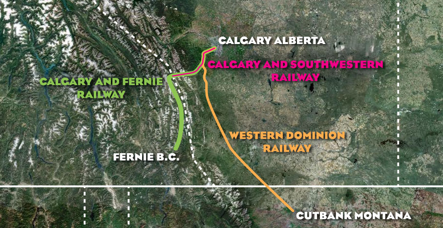
The above map shows the general location of the three lines that had been planned to cross the Tsuut’ina reserve in the early part of the 20th century: the Calgary and Fernie Railway, the Western Dominion Railway and the Calgary and Southwestern Railway. Continue reading “The Railways of the Tsuut’ina reserve”

Advertisement

The Ring Road System – Integrated Planning (1974-1976)

While the City of Calgary, and later the Province of Alberta, had addressed the concept of a ring road network around Calgary before, it wasn’t until the 1970s that the idea was formalised into a singular road plan. (Much more on the early history of the road in part one of this four part series)

1974 CALGARY PARKWAY RING (Province of Alberta)

1974 saw the completion of the first comprehensive report on the Calgary Ring Road, known at this time as the Calgary Parkway Ring, which was produced by the firm of Deleuw Cather Consulting Engineers and Planners, on behalf of the Provincial government. This report not only laid out the route and general design of the road, but it also explored the need for the road itself, and the concept of the road as part of a larger system, integrated with other amenities such as public transportation and parks. Continue reading “The Ring Road System – Integrated Planning (1974-1976)”

Midnapore

Home to over 75,000 calgary residents, the development area of Midnapore (not to be confused with the singular community of Midnapore) has become an integral part of the story of the Southwest Calgary Ring Road. Hemmed in by several geographic and political obstacles, transportation in the area has been problematic, and has always been at the forefront of planning. Despite early efforts to ensure that the area developed within the means of the transportation system in the area, this considered planning has been recently ignored, and housing development has been allowed to surpass the capacity of the road network. The pressure on (and the occasional failure of) the transportation network has prompted increasing calls for new links to the area, specifically the ring road.

The area of Midnapore is defined by Fish Creek provincial park to the North and East, Highway 22x to the South, and 37th street SW to the West.

Continue reading “Midnapore”