90th Avenue and the Southwest Ring Road

First appearing on plans together nearly 60 years ago, and shown as connected in every major road plan since, 90th avenue SW and the Southwest Calgary Ring Road have a long and inseparable history. The connection of these two roads together, initially planned out of convenience, and later out of necessity, continues to play a significant role in the history of the ring road. Calls to keep 90th avenue from being connected to the ring road have been heard in recent years, and it is important to understand the history of this road, and why the connection of 90th avenue is seen as an indispensable part of the ring road plan.

The Origins of 90th Avenue SW

1953_90th

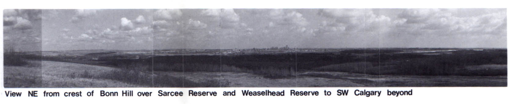
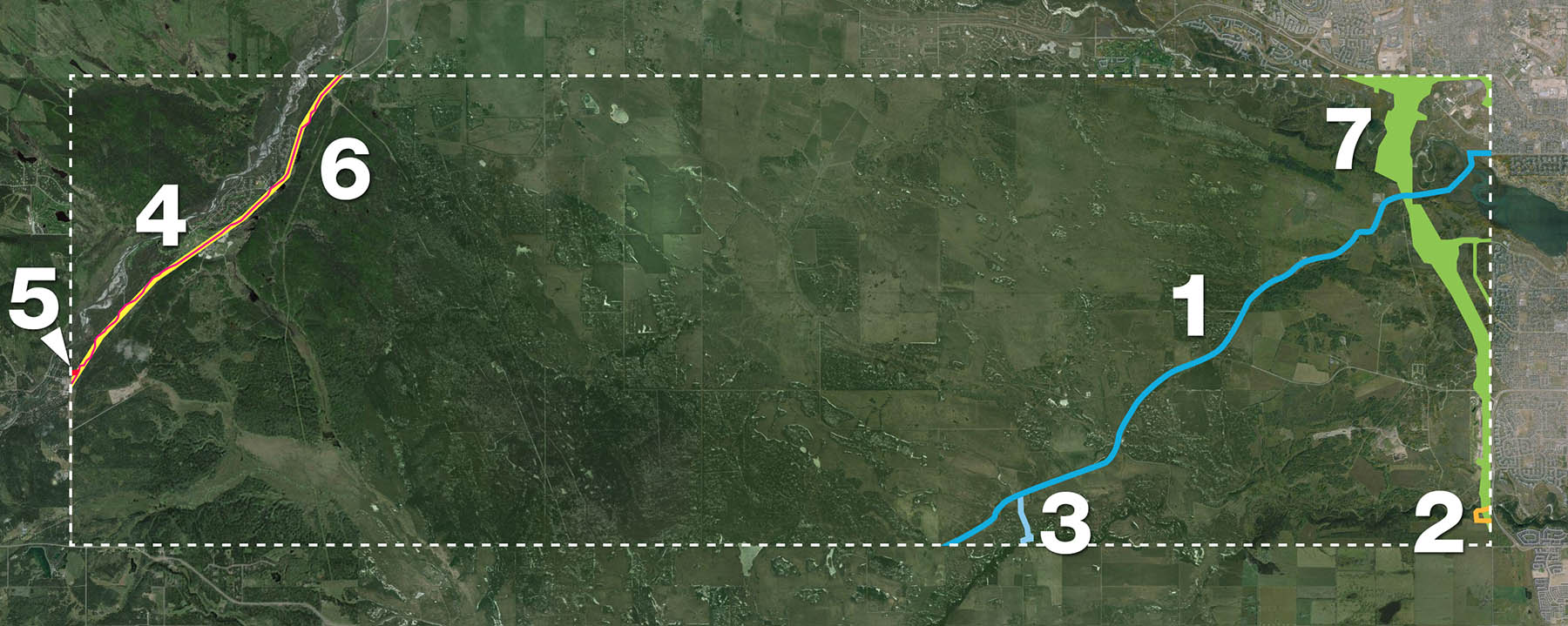
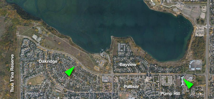
90th avenue is an arterial road in Calgary’s southwest, south of the Glenmore Reservoir, that has existed in some form or another since the early days of the City. Early settlers in the region traveled its path to access their land, and by the early 20th century, a dirt road had been created which served a small number of homesteads in the area. This arrangement, pictured above in 1953, went largely unchanged for many years. When the foreseeable encroachment of an expanding City of Calgary finally necessitated it, bigger plans for the road were initiated.

Forward Planning and a Growing City

In the early to mid 1950s the City had begun to more fully embrace a civic planning program; one that was more forward looking than had been undertaken in decades. The City was creating plans for areas that were then rural, but would one day be developed as part of a rapidly-growing City. The earliest modern plan for 90th avenue can be traced back to 1953 when the City created it’s earliest internal Ring Road plan. 90th avenue SW between Macleod Trail and 37th street SW was at that time an integral part of the Ring Road, and formed the southern portion of the City’s first complete Southwest Calgary Ring Road route.

1953-highlight

(Source: Untitled Map. December 1953. City of Calgary Corporate Records, Archives. Board of Commissioners S. IV box 189 F. 39.)

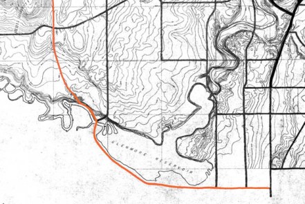
This configuration did not last long, and soon the main Ring Road route continued south, beyond 90th avenue SW. By 1956 a masterplan for the development of parks around the Glenmore Reservoir was developed by the City (shown below), and included a modified 90th avenue SW proposal. These plans mark the first time that plans for the Southwest Calgary Ring Road and 90th avenue SW were shown to the public.

Glennore_1956Then called ‘South Glenmore Drive’, 90th avenue was depicted much as we know it today, running from 14th street SW to 37th street SW, where it connected directly to the ring road. This basic layout was retained in Calgary’s first approved transportation plan, 1959’s Calgary Metropolitan Transportation Plan (shown below as 92nd avenue).

1959_90th Continue reading “90th Avenue and the Southwest Ring Road”

Advertisement

From No to Maybe: The turning point for the SW Ring Road, part 2

This article follows on from the previous article, From No to Maybe: The turning point for the SW Ring Road, part 1.

—–

By the close of the 1970s, the Tsuut’ina Nation and the City of Calgary seemed to be at an impasse regarding the Southwest Calgary Ring Road (or the Sarcee Trail Extension, as it was then known). Though generally indicating resistance to the idea of allowing a road through the reserve, the Nation nonetheless had been willing to continue to engage with the City in discussions, noting that any chance of success hinged on the Nation deriving certain benefits from the road. The City meanwhile had seemingly made it clear that they were not prepared to entertain certain requests of the Nation, particularly access from the ring road to potential developments on the reserve, and the extension of City utilities to those developments.

1984_reserve_view

At the same time, and in a seemingly contradictory move, the City had begun to limit itself from building the road along a route through the Weaselhead area within the City limits, thus ensuring that it needed to acquire land from the Nation in order to build the road. Though conditions to this point had not yet been right for progress, both parties seemed to be heading towards a middle ground, and information and cooperation were the last hurdles to clear before the story of the ring road could move forward. Continue reading “From No to Maybe: The turning point for the SW Ring Road, part 2”

Ring Road Update March 2014

The recent release of the 2014 Provincial Budget brought with it some new details regarding the funding of the Southwest Calgary Ring Road. In addition, the Province has released some initial timing and staging details regarding the implementation of the road, including the possible division of the road into two separate construction projects.

ringroad_march_2014

The Budget and the $5 Billion Price Tag

Released on March 6, the 2014 Alberta Budget sets aside $2.698 billion towards both Calgary and Edmonton’s ring road projects over the next three years. Of this, Finance Minister Doug Horner noted that $1.8 billion is to be dedicated to the Southwest Calgary Ring Road. In an address on March 7 to the Calgary Chamber of Commerce, Minister Horner reportedly stated that the full construction of the remaining portion of Calgary’s ring road would cost around $5 billion. The decision to deliver the project via traditional delivery or through Public Private Partnerships has yet to be made, and the Province is currently “investigating the viability of delivering the final segment of Calgary’s ring road in two separate projects using the Public Private Partnership (P3) procurement process” Continue reading “Ring Road Update March 2014”

The West Calgary Ring Road

Though the route of the southwest ring road through the Tsuut’ina reserve has in recent years garnered the most attention of the unfinished portions of Calgary’s bypass network, there are actually two additional pieces of infrastructure needed to complete the ring. Aside from the south leg, which extends the road to Macleod Trail in the south, there is also the West Calgary Ring Road, defined as the portion of the road that connects the Trans Canada Highway to Highway 8. This is the piece that I will cover here.

Early West Side Planning

1956-2009_west_ring_road

The earliest complete plans for a ring road around Calgary, dating from 1956, plotted much of the western leg of the circuit along the 53rd street SW corridor, better known today as Sarcee Trail. While the route to the north and south of this leg would undergo revisions, this western portion would remain largely unchanged for nearly 30 years, and the road would continue to be planned along the Sarcee Trail corridor until the mid 1980s. Continue reading “The West Calgary Ring Road”

A Brief History of the Southeast Calgary Ring Road

The opening of the southeast Calgary ring road in November marked not only the completion of over three years of construction, but also of the fulfillment of a goal first set out by the Province of Alberta nearly 60 years earlier.

1955-2013_SE(A progression of bypass proposals for East Calgary is shown above)

Early Bypasses

In the 1950s, when bypass plans were first considered for the Calgary area, the city’s main arterial roads radiated from the core, and the primary bridges over the City’s rivers were largely located downtown. To access the industrial southeast, residents living in the new suburbs of the northwest and southwest would have to drive through or near the increasingly congested core. In order to allow drivers not bound for downtown to bypass central Calgary, and in order to allow long-range travelers to connect between major highways without adding to the congestion of the city, several bypass roads would be proposed that would avoid the city centre. These early bypass plans would include such a facility along the city’s southeastern edge.

Continue reading “A Brief History of the Southeast Calgary Ring Road”

SW Ring Road Signing

At a ceremony today, held at the Tsuut’ina Seven Chiefs Sportsplex, the 2013 ring road agreement was signed by Tsuut’ina Chief Roy Whitney, Premier Alison Redford and Transportation Minister Ric McIver.

2013_signing(Picture courtesy of Parker Hogan, Alberta Transportation)

Noting the agreement signifies the beginning of a long friendship between the Province and the Nation, McIver stated that the name of the road will be chosen by the Tsuut’ina, and that the project will include Tsuut’ina motifs. Chief Whitney noted that discussions of the ring road through the Nation have been ongoing for ‘over 60 years’, and that the project will bring benefits for the language, culture and economics of the Nation. He also characterized the agreement as probably the most important modern event in the history of the Tsuut’ina.

photo (2)

(Picture courtesy of Amy Lonsberry)

The signing of the agreement marks a historic milestone in the development of this road, and has moved the Southwest Calgary Ring Road project forward with the next steps involving the approval of the federal government. McIver stated in a press release “We will work in partnership with the Tsuut’ina Nation and the federal government to proceed with the land transfer. This work will be guided by a committee with representatives from all parties and we will continue to work together in good faith.”

Once the land transfers have been enacted, the Province will have seven years to complete the opening phase of the southwest ring road.

Road Purchases and Surrenders

The October 2013 ring road agreement between the Province of Alberta and the Tsuut’ina Nation has recently been heralded by the Province and the media as a historic agreement between these two parties. While the scale, compensation and long-term impacts of this deal are indeed unique, representing the largest ever land purchase from the Tsuut’ina reserve and the potential opening of the reserve for unprecedented development, it is not the first time a road corridor has been acquired by the Province through the reserve. The ring road agreement actually represents the seventh time that a Provincial road corridor has been secured through Tsuut’ina lands.

all_corridors_1900-20131. Priddis Trail, 1900
2. 37th Street SW, 1910
3. Priddis Trail Diversion, 1916
4. Highway 22/Bragg Creek Road, 1922
5. Balsam Avenue Bridge Approach, 1934
6. Highway 22 Widening, 1955
7. Southwest Calgary Ring Road, 2013

Continue reading “Road Purchases and Surrenders”

Southwest Ring Road Deal Accepted by Tsuut’ina Nation

Several media outlets are reporting that in a vote held on Thursday, October 24 2013, the Tsuut’ina Nation voted in favour of accepting a deal to sell and trade reserve land to the Province of Alberta for the Southwest Ring Road. While the results will not be officially announced until midday on Friday, at a press conference to be held by Chief Roy Whitney, the agreement is reported to have been accepted with around 68% of the vote.

The details of the deal have yet to be revealed, though a separate press conference set to be held at 2pm Friday afternoon by Transportation Minister Ric McIver and Premier Alison Redford may contain more information about the agreement. The acceptance of this deal marks a historic agreement between the Province and the Tsuut’ina Nation, on a project first detailed to the public nearly 60 years ago.

On Friday, November 18 1955 Minister of Highways Gordon Taylor addressed the Calgary Chamber of Commerce at the Palliser Hotel with an update of the highways program for the upcoming year. Among the talk of highways and interchanges was mention of a bypass road that would connect the Macleod Trail with the still-under-construction Trans Canada Highway. This road had two proposed routes, including an ambitious long-range plan that would have seen the road travel west along Anderson Road, then north across the Elbow River west of the reservoir. While the route would change and the City would grow, the first public seeds of the Southwest Ring Road were sewn on that day.

Much work will be required over the next few years before a Southwest Ring Road is completed, but it would seem that the groundwork has been laid for both the road itself and future developments on the reserve that will follow.

Details about the road design and the agreement will be covered when they are released.

2013 Referendum

On September 19 2013, Transportation Minister Ric McIver confirmed a story published in the Calgary Journal the day before, and announced that the past several years of negotiations between the Tsuu T’ina and the Province regarding the ring road had come to a fruitful conclusion with the finalization of a new ring road deal. According to the Journal, on September 10 the Tsuu T’ina Council had approved a tentative deal regarding the land and compensation required to build the southwest Calgary ring road through the First Nation reserve. With a deal agreed upon by the Province and the Nation’s Council, all that remains is a referendum of Tsuu T’ina members, which has been set for October 24 2013. This marks only the second time that an agreement will come to a referendum of Nation members; the first, in 2009, was rejected.

Continue reading “2013 Referendum”