From No to Maybe: The turning point for the SW Ring Road, part 2

This article follows on from the previous article, From No to Maybe: The turning point for the SW Ring Road, part 1.

—–

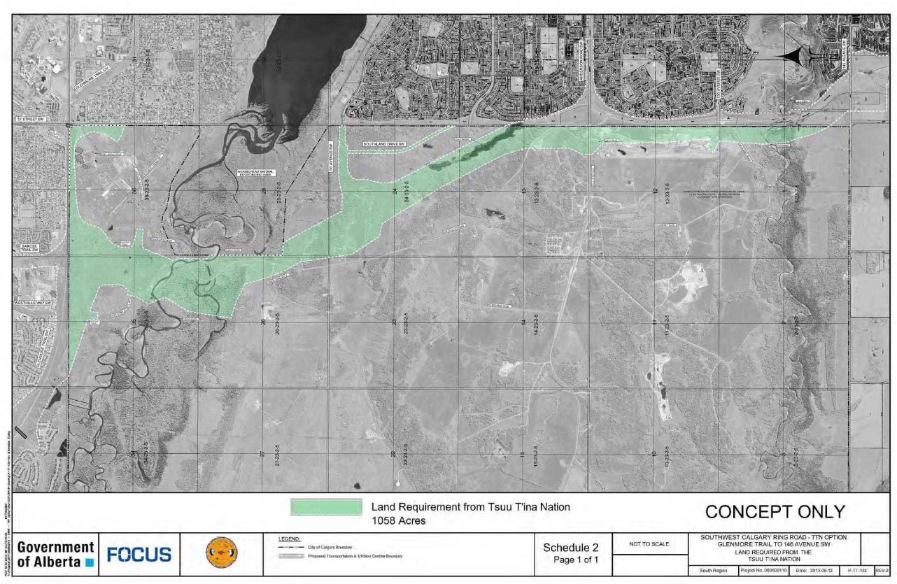
By the close of the 1970s, the Tsuut’ina Nation and the City of Calgary seemed to be at an impasse regarding the Southwest Calgary Ring Road (or the Sarcee Trail Extension, as it was then known). Though generally indicating resistance to the idea of allowing a road through the reserve, the Nation nonetheless had been willing to continue to engage with the City in discussions, noting that any chance of success hinged on the Nation deriving certain benefits from the road. The City meanwhile had seemingly made it clear that they were not prepared to entertain certain requests of the Nation, particularly access from the ring road to potential developments on the reserve, and the extension of City utilities to those developments.

1984_reserve_view

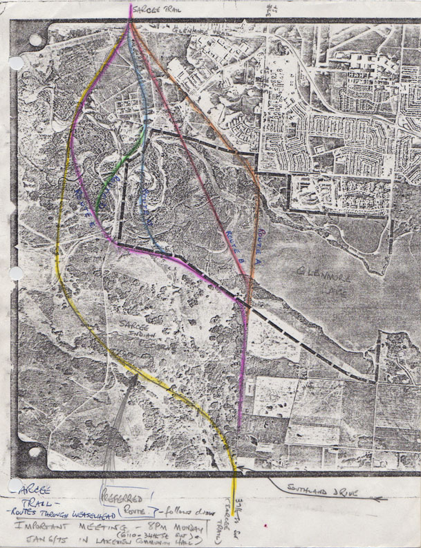
At the same time, and in a seemingly contradictory move, the City had begun to limit itself from building the road along a route through the Weaselhead area within the City limits, thus ensuring that it needed to acquire land from the Nation in order to build the road. Though conditions to this point had not yet been right for progress, both parties seemed to be heading towards a middle ground, and information and cooperation were the last hurdles to clear before the story of the ring road could move forward. Continue reading “From No to Maybe: The turning point for the SW Ring Road, part 2”

Advertisement

Ring Road Update March 2014

The recent release of the 2014 Provincial Budget brought with it some new details regarding the funding of the Southwest Calgary Ring Road. In addition, the Province has released some initial timing and staging details regarding the implementation of the road, including the possible division of the road into two separate construction projects.

ringroad_march_2014

The Budget and the $5 Billion Price Tag

Released on March 6, the 2014 Alberta Budget sets aside $2.698 billion towards both Calgary and Edmonton’s ring road projects over the next three years. Of this, Finance Minister Doug Horner noted that $1.8 billion is to be dedicated to the Southwest Calgary Ring Road. In an address on March 7 to the Calgary Chamber of Commerce, Minister Horner reportedly stated that the full construction of the remaining portion of Calgary’s ring road would cost around $5 billion. The decision to deliver the project via traditional delivery or through Public Private Partnerships has yet to be made, and the Province is currently “investigating the viability of delivering the final segment of Calgary’s ring road in two separate projects using the Public Private Partnership (P3) procurement process” Continue reading “Ring Road Update March 2014”

From No to Maybe: The turning point for the SW Ring Road, part 1

The approval of a ring road agreement between the Tsuut’ina and the Province of Alberta in October of 2013 has opened the door for the long-planned Southwest Calgary Ring Road to be built through what is currently the Tsuut’ina Nation reserve. By any measure, the vote to accept the deal was overwhelmingly in favour, but the idea of selling reserve land for the freeway has not always been a popular one amongst Nation members.

With a deal now agreed to locate the ring road through the reserve, a once formidable divide between the idea of retaining reserve land and selling it has seemingly been bridged, but what changed? Why has that idea of selling the land, once thoroughly rejected by Tsuut’ina members and leadership, now been embraced?

Ring Road Planning

Although Calgary had planned for a ring road from as early as the mid-1950s, the early designs would have seen limited, or at times non-existent, incursions into the Tsuut’ina reserve. Early designs were proposed to be largely located within Calgary’s city limits, and while there have been sporadic discussions between the City and the Nation regarding the acquisition of land for a road, in the early days these talks would appear to be perfunctory.

It wasn’t until the 1970s that more considered thought was given to planning the Southwest Calgary Ring Road through the Tsuut’ina reserve in a substantial way.

1975_ROUTE_F Continue reading “From No to Maybe: The turning point for the SW Ring Road, part 1”

The West Calgary Ring Road

Though the route of the southwest ring road through the Tsuut’ina reserve has in recent years garnered the most attention of the unfinished portions of Calgary’s bypass network, there are actually two additional pieces of infrastructure needed to complete the ring. Aside from the south leg, which extends the road to Macleod Trail in the south, there is also the West Calgary Ring Road, defined as the portion of the road that connects the Trans Canada Highway to Highway 8. This is the piece that I will cover here.

Early West Side Planning

1956-2009_west_ring_road

The earliest complete plans for a ring road around Calgary, dating from 1956, plotted much of the western leg of the circuit along the 53rd street SW corridor, better known today as Sarcee Trail. While the route to the north and south of this leg would undergo revisions, this western portion would remain largely unchanged for nearly 30 years, and the road would continue to be planned along the Sarcee Trail corridor until the mid 1980s. Continue reading “The West Calgary Ring Road”

A Brief History of the Southeast Calgary Ring Road

The opening of the southeast Calgary ring road in November marked not only the completion of over three years of construction, but also of the fulfillment of a goal first set out by the Province of Alberta nearly 60 years earlier.

1955-2013_SE(A progression of bypass proposals for East Calgary is shown above)

Early Bypasses

In the 1950s, when bypass plans were first considered for the Calgary area, the city’s main arterial roads radiated from the core, and the primary bridges over the City’s rivers were largely located downtown. To access the industrial southeast, residents living in the new suburbs of the northwest and southwest would have to drive through or near the increasingly congested core. In order to allow drivers not bound for downtown to bypass central Calgary, and in order to allow long-range travelers to connect between major highways without adding to the congestion of the city, several bypass roads would be proposed that would avoid the city centre. These early bypass plans would include such a facility along the city’s southeastern edge.

Continue reading “A Brief History of the Southeast Calgary Ring Road”

SW Ring Road Signing

At a ceremony today, held at the Tsuut’ina Seven Chiefs Sportsplex, the 2013 ring road agreement was signed by Tsuut’ina Chief Roy Whitney, Premier Alison Redford and Transportation Minister Ric McIver.

2013_signing(Picture courtesy of Parker Hogan, Alberta Transportation)

Noting the agreement signifies the beginning of a long friendship between the Province and the Nation, McIver stated that the name of the road will be chosen by the Tsuut’ina, and that the project will include Tsuut’ina motifs. Chief Whitney noted that discussions of the ring road through the Nation have been ongoing for ‘over 60 years’, and that the project will bring benefits for the language, culture and economics of the Nation. He also characterized the agreement as probably the most important modern event in the history of the Tsuut’ina.

photo (2)

(Picture courtesy of Amy Lonsberry)

The signing of the agreement marks a historic milestone in the development of this road, and has moved the Southwest Calgary Ring Road project forward with the next steps involving the approval of the federal government. McIver stated in a press release “We will work in partnership with the Tsuut’ina Nation and the federal government to proceed with the land transfer. This work will be guided by a committee with representatives from all parties and we will continue to work together in good faith.”

Once the land transfers have been enacted, the Province will have seven years to complete the opening phase of the southwest ring road.

Road Purchases and Surrenders

The October 2013 ring road agreement between the Province of Alberta and the Tsuut’ina Nation has recently been heralded by the Province and the media as a historic agreement between these two parties. While the scale, compensation and long-term impacts of this deal are indeed unique, representing the largest ever land purchase from the Tsuut’ina reserve and the potential opening of the reserve for unprecedented development, it is not the first time a road corridor has been acquired by the Province through the reserve. The ring road agreement actually represents the seventh time that a Provincial road corridor has been secured through Tsuut’ina lands.

all_corridors_1900-20131. Priddis Trail, 1900
2. 37th Street SW, 1910
3. Priddis Trail Diversion, 1916
4. Highway 22/Bragg Creek Road, 1922
5. Balsam Avenue Bridge Approach, 1934
6. Highway 22 Widening, 1955
7. Southwest Calgary Ring Road, 2013

Continue reading “Road Purchases and Surrenders”

2013 Agreement and Design

The 2013 Ring Road Agreement between the Tsuut’ina Nation and the Province of Alberta was announced on Friday October 25 2013, marking the conclusion of the latest round of negotiations. A new deal, which was crucial in addressing concerns regarding the previous agreement from 2009, contains new compensation levels, new guarantees, and a slightly modified design for the road.

UPDATE JULY 2015: The Federal Government approved the addition to the Tsuut’ina reserve and the transfer of the road corridor to the Province in May 2015. Click here for all of the details.

The Nation will receive from the Province:

Guaranteed 5338.1 acres of crown land located to the west of the current reserve, which will be converted into reserve status, valued at $44,420,683.50 (See lands map below). The total land figure includes 5,018.1 acres of crown lands provided as compensation in the agreement (Shown in yellow in the map below), as well as an additional 320 acres of crown land that the Nation will purchase for $1,643,000 (Shown in blue in the map below).
• $275,000,000 in cash
• $65,643,900 additional funds to be used for the relocation and reconstruction costs for homes, businesses and roads currently located in the path of the road.

tsuutina_Land_Request_with_Consultation_Area_August16_2013.dgn

The Province will receive from the Nation:

1058 acres needed for the Transportation Utility Corridor (TUC) where the ring road would be built (shaded green in the map below)

In addition and apart from this agreement, the plan would see approximately 8 acres from the SW corner of the Weaselhead park purchased by the Province from the City of Calgary, while the existing high-pressure natural gas line and overhead transmission lines that run through the park would be removed from the natural area.

2013-09-05 Tsuu T'ina Final Agreement - Final

OTHER ASPECTS OF THE DEAL

In addition to the financial compensation and land transfers contained in the agreement, there are other clauses that dictate how the road would be implemented.

Continue reading “2013 Agreement and Design”

Southwest Ring Road Deal Accepted by Tsuut’ina Nation

Several media outlets are reporting that in a vote held on Thursday, October 24 2013, the Tsuut’ina Nation voted in favour of accepting a deal to sell and trade reserve land to the Province of Alberta for the Southwest Ring Road. While the results will not be officially announced until midday on Friday, at a press conference to be held by Chief Roy Whitney, the agreement is reported to have been accepted with around 68% of the vote.

The details of the deal have yet to be revealed, though a separate press conference set to be held at 2pm Friday afternoon by Transportation Minister Ric McIver and Premier Alison Redford may contain more information about the agreement. The acceptance of this deal marks a historic agreement between the Province and the Tsuut’ina Nation, on a project first detailed to the public nearly 60 years ago.

On Friday, November 18 1955 Minister of Highways Gordon Taylor addressed the Calgary Chamber of Commerce at the Palliser Hotel with an update of the highways program for the upcoming year. Among the talk of highways and interchanges was mention of a bypass road that would connect the Macleod Trail with the still-under-construction Trans Canada Highway. This road had two proposed routes, including an ambitious long-range plan that would have seen the road travel west along Anderson Road, then north across the Elbow River west of the reservoir. While the route would change and the City would grow, the first public seeds of the Southwest Ring Road were sewn on that day.

Much work will be required over the next few years before a Southwest Ring Road is completed, but it would seem that the groundwork has been laid for both the road itself and future developments on the reserve that will follow.

Details about the road design and the agreement will be covered when they are released.

The History of Ring Road Negotiations

On the day of a vote by the Tsuu T’ina Nation on a potential deal to sell and trade land for the Southwest Calgary Ring Road, it’s worth looking at the history of the negotiations for this road.

Many commentators have made statements to the effect that the City of Calgary or the Province of Alberta have been negotiating with the Nation over land for the ring road for upwards of 60 years. While it’s true that designs for the road, even from the very beginning, have shown the road on reserve land, it cannot be said that true negotiations have been underway since that time. Though conversations have certainly taken place for decades, the current negotiations can be traced back to about 2004, with modern negotiations starting in 1998, and prior to 1984 the Nation were largely opposed to the entire notion of running a major freeway through their land.

1956
The earliest ring road plans are revealed to the public. Mayor Don Mackay states that a small portion of the road, particularly the interchange with what would become 90th avenue, would cross the Tsuu T’ina reserve. Mayor Mackay said “Think of the possibilities for a great tourist attraction this would provide for the Indians… They could line the road, as it crosses their territory, with teepees and provide a wonderful sight.”

1956_a

Soon the proposed road would be altered from these early plans, and the officially approved route in 1959 was not noted to require land from the reserve. No formal discussions are known to have taken place with the Nation regarding the purchase of land at this time.

(For more on the early road, click here) Continue reading “The History of Ring Road Negotiations”