Land Transfers

There has been discussion about the potential for a land transfer component in the pending southwest Calgary ring road deal between the Province and the Tsuu T’ina. Concerns have been raised publicly about the status of the new land that the Tsuu T’ina might acquire, and whether or not this land would be integrated into the reserve. In a recent Calgary Journal article, Jean Crowder, MP and Official Opposition Critic for Aboriginal Affairs, questioned whether the new lands included in the agreement would in fact be reserve land.

new_reserve_lands

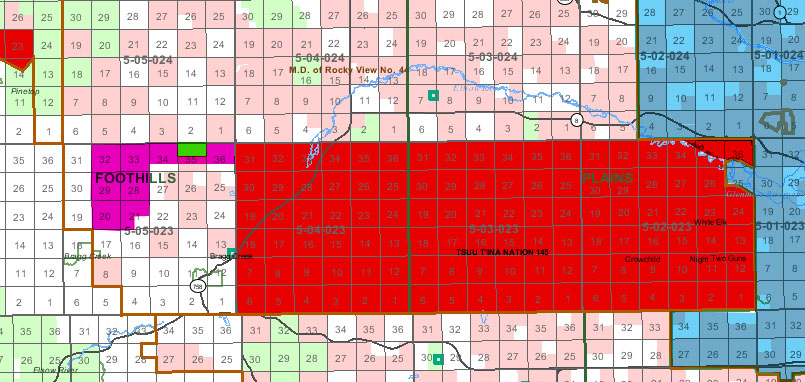
The map above shows the new lands (magenta) proposed to be added to the reserve (red) in the 2009 deal.

Without knowing the details of the 2013 agreement, we can currently only look at the 2009 deal to see how land ownership and transfers were proposed in regards to this project. The details about ownership and transfer that follow are based on the wording of the 2009 deal (which can be downloaded in full here). For a further look at the 2009 deal, click here. Continue reading “Land Transfers”

Advertisement

Unexploded Ordnance in Southwest Calgary

The 2013 southern Alberta floods did more to Calgary than damage houses and severely interrupt lives; the floods unearthed and highlighted a problem that has caused concern, and worse, for decades. In July, two unexploded military shells were found on the shores of the Elbow river in the Weaselhead area, exposing a legacy of unexploded ordnances (UXO) that lie just beneath the surface of a portion of southwest Calgary, including the potential route of the southwest ring road.

weaselhead_uxo

(Image of shell found in the Weaselhead area, July 2 2013. Courtesy Mark Langenbacher) Continue reading “Unexploded Ordnance in Southwest Calgary”

The Many Crossings of Highway 22

The Southwest Calgary Ring Road may be the best known provincial road designed to cross Tsuu T’ina land, but it wasn’t the first road sought through the reserve. In fact, it is at least the fourth road, either built or not, that the Province planned to cross the reserve. The three previous road plans, of which only one is operating today (and one  never built), are also related in another way; they were all earmarked at one time or another to be the route of Highway 22.

reserve_overall

The Priddis Trail and the Original Highway 22

The road known as the Priddis Trail was not only the first road to be considered for the role of Highway 22, it actually predates the building of that highway by many years. The road was officially established by the Province in 1900 after being surveyed for the first time in 1899. However, the route is even older than that. The Priddis Trail was set out along a much older trail that had been in use by local First Nations for decades, if not centuries. The trail is shown below in 1897.

PriddisTrail_1897 Continue reading “The Many Crossings of Highway 22”

The Ring Road System – The Provincial Road (2001 to 2012)

This is the fourth and final part of my overview of the Calgary Ring Road project, covering the period from 2000 to the current day. In many ways this is the period that moved the full ring road project from concept to reality. Despite a small portion having been built in the previous decade, work on a high-capacity, free-flowing provincial highway got underway in earnest after the turn of the millennium; work that is still ongoing today. (Click here for Part 1: 1956-1970, here for Part 2 1974-1976, and here for Part 3 1980-2001) As always, click on any of the maps for a larger view.

futureringroad

BECOMING A PROVINCIAL HIGHWAY

In 2000, the City of Calgary and the Province of Alberta signed an agreement that transfered the control of both the Deerfoot Trail and Stoney Trail to the Province. Despite the road originating in Provincial plans, and being primarily designed by the Province since the 1970s, the Calgary ring road had to this point been a City road. Continue reading “The Ring Road System – The Provincial Road (2001 to 2012)”

The Ring Road System – Implementation (1980 to 2001)

This is the third of a four part series on the history of Calgary’s ring road, covering the period when construction of the road first began. While this site continues to focus on the Southwest portion, I wanted to cover the history of the rest of the road, to provide some context to the story. Part one of this series (Initial Outlines) can be found here, and part two (Integrated Planning) can be found here.

After many studies, and many more years of planning, this period marked the first time that physical work on the project was undertaken, and the road was finally becoming a reality. Even with the route of the Transportation Utility Corridor (TUC) being largely set in the 1970s, the path to a finished road was never going to be straightforward. In this period there were (and still are) many issues to resolve, agreements to make, and studies to undertake. Despite the false-starts and the setbacks involved in the business of actually constructing a road, significant progress was made; the ring road went from being a line on a map to the beginnigs of a constructed freeway system that is currently close to being three-quarters finished. Continue reading “The Ring Road System – Implementation (1980 to 2001)”

The Ring Road System – Integrated Planning (1974-1976)

While the City of Calgary, and later the Province of Alberta, had addressed the concept of a ring road network around Calgary before, it wasn’t until the 1970s that the idea was formalised into a singular road plan. (Much more on the early history of the road in part one of this four part series)

1974 CALGARY PARKWAY RING (Province of Alberta)

1974 saw the completion of the first comprehensive report on the Calgary Ring Road, known at this time as the Calgary Parkway Ring, which was produced by the firm of Deleuw Cather Consulting Engineers and Planners, on behalf of the Provincial government. This report not only laid out the route and general design of the road, but it also explored the need for the road itself, and the concept of the road as part of a larger system, integrated with other amenities such as public transportation and parks. Continue reading “The Ring Road System – Integrated Planning (1974-1976)”

Midnapore

Home to over 75,000 calgary residents, the development area of Midnapore (not to be confused with the singular community of Midnapore) has become an integral part of the story of the Southwest Calgary Ring Road. Hemmed in by several geographic and political obstacles, transportation in the area has been problematic, and has always been at the forefront of planning. Despite early efforts to ensure that the area developed within the means of the transportation system in the area, this considered planning has been recently ignored, and housing development has been allowed to surpass the capacity of the road network. The pressure on (and the occasional failure of) the transportation network has prompted increasing calls for new links to the area, specifically the ring road.

The area of Midnapore is defined by Fish Creek provincial park to the North and East, Highway 22x to the South, and 37th street SW to the West.

Continue reading “Midnapore”