The West Calgary Ring Road

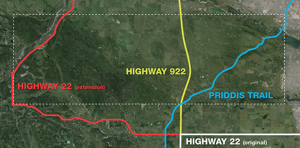
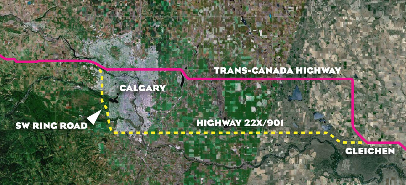
Though the route of the southwest ring road through the Tsuut’ina reserve has in recent years garnered the most attention of the unfinished portions of Calgary’s bypass network, there are actually two additional pieces of infrastructure needed to complete the ring. Aside from the south leg, which extends the road to Macleod Trail in the south, there is also the West Calgary Ring Road, defined as the portion of the road that connects the Trans Canada Highway to Highway 8. This is the piece that I will cover here.

Early West Side Planning

1956-2009_west_ring_road

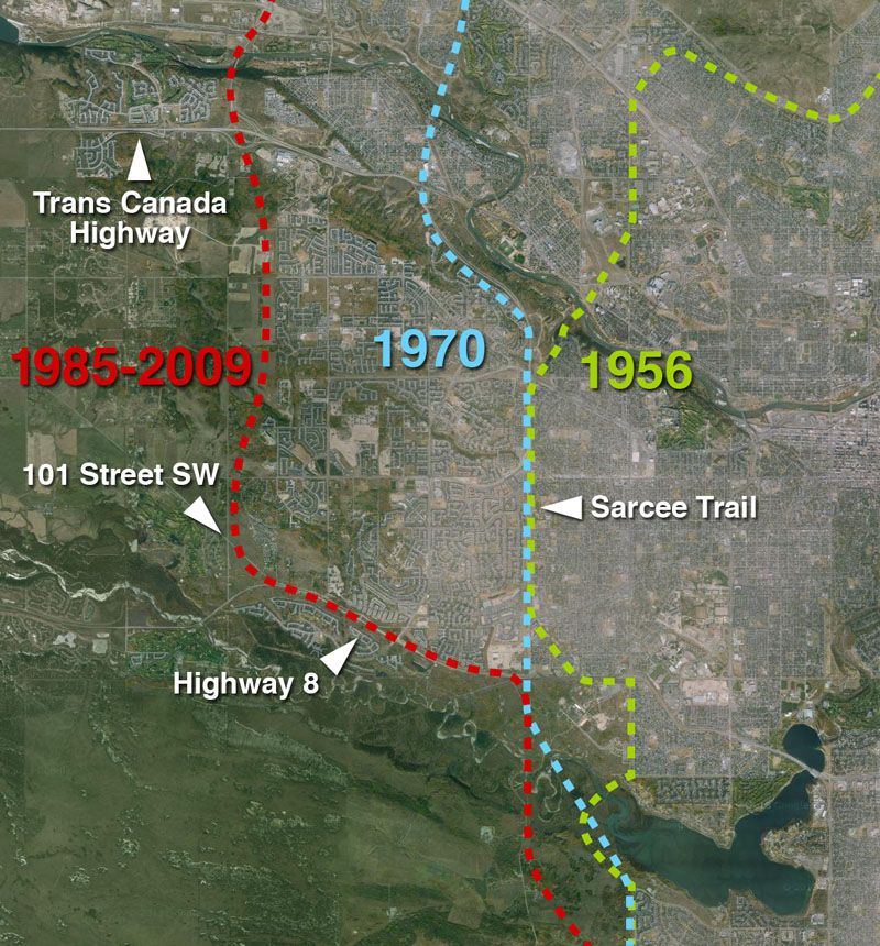
The earliest complete plans for a ring road around Calgary, dating from 1956, plotted much of the western leg of the circuit along the 53rd street SW corridor, better known today as Sarcee Trail. While the route to the north and south of this leg would undergo revisions, this western portion would remain largely unchanged for nearly 30 years, and the road would continue to be planned along the Sarcee Trail corridor until the mid 1980s. Continue reading “The West Calgary Ring Road”

Advertisement

Unexploded Ordnance in Southwest Calgary

The 2013 southern Alberta floods did more to Calgary than damage houses and severely interrupt lives; the floods unearthed and highlighted a problem that has caused concern, and worse, for decades. In July, two unexploded military shells were found on the shores of the Elbow river in the Weaselhead area, exposing a legacy of unexploded ordnances (UXO) that lie just beneath the surface of a portion of southwest Calgary, including the potential route of the southwest ring road.

weaselhead_uxo

(Image of shell found in the Weaselhead area, July 2 2013. Courtesy Mark Langenbacher) Continue reading “Unexploded Ordnance in Southwest Calgary”

The Many Crossings of Highway 22

The Southwest Calgary Ring Road may be the best known provincial road designed to cross Tsuu T’ina land, but it wasn’t the first road sought through the reserve. In fact, it is at least the fourth road, either built or not, that the Province planned to cross the reserve. The three previous road plans, of which only one is operating today (and one  never built), are also related in another way; they were all earmarked at one time or another to be the route of Highway 22.

reserve_overall

The Priddis Trail and the Original Highway 22

The road known as the Priddis Trail was not only the first road to be considered for the role of Highway 22, it actually predates the building of that highway by many years. The road was officially established by the Province in 1900 after being surveyed for the first time in 1899. However, the route is even older than that. The Priddis Trail was set out along a much older trail that had been in use by local First Nations for decades, if not centuries. The trail is shown below in 1897.

PriddisTrail_1897 Continue reading “The Many Crossings of Highway 22”

1977 Sarcee Trail South Route Location Study

Though the planning for a Southwest Ring Road had been started in the early-to-mid 1950s, it remained little more than a line on a map for the next few decades. It took the pressures of growth, and the establishment of a new Provincial park, for the City to move the project from long-range thinking to a more detailed phase of planning. By the mid 1970s the planning for the Sarcee Trail extension, as it was then known, had become a priority to the City, even if the need for the road was recognised to still be decades away.

1977_cover

The study would look at routes that traveled from Glenmore Trail to Highway 22x, though I will focus on the portion that crosses the Elbow River, from Glenmore Trail to Anderson Road. For more on the crossing of the Fish Creek, see here. Continue reading “1977 Sarcee Trail South Route Location Study”

The Railways of the Tsuut’ina reserve

CP_engine

The concept of a Provincial road crossing Tsuut’ina land is a well established one, with two having been built, another shelved, and the Southwest Calgary Ring Road still under negotiations. However, the idea of a railway through southwest Calgary and the reserve might be a little more surprising. Around 100 years ago no less than three Railways were planned to traverse the reserve, lying as it does between Calgary, the southern Alberta coal and oil fields, and the American northwest beyond.

Though the relationship between the Southwest Calgary Ring Road and these railway projects of another century might not be obvious, their stories of infrastructure development, of planned economic prosperity through the ability to transport goods, and of the reserve’s role in potentially providing a path for these projects illustrate a long history of public and private transportation interests in the Tsuut’ina land. It is also worth noting that the Indian Act, which governs the First Nations reserve system in Canada, was amended in 1911 to allow for the expropriation of reserve land for road and railway projects. The plans shown below would likely not have required the permission of the Tsuut’ina to have been built.

sw_railway_overview

The above map shows the general location of the three lines that had been planned to cross the Tsuut’ina reserve in the early part of the 20th century: the Calgary and Fernie Railway, the Western Dominion Railway and the Calgary and Southwestern Railway. Continue reading “The Railways of the Tsuut’ina reserve”

37th street SW, from Anderson Road to Highway 22x

This is the third post regarding the role of 37th street in the ring road story. Part 1, Glenmore trail to 66th avenue SW, and Part 2, 90th avenue SW to Anderson road can be found here. This third part covers the 37th street corridor between Anderson road and Highway 22x.

The Early Road

37th_1948-2010

Located at the dividing line between the Tsuu T’ina Nation and the City of Calgary, it is natural that a road would emerge along the 37th street SW corridor. Marking the edge of Township 23, Range 1 West of the 5th Meridian, a road right-of-way had been established with the creation of the township land system for Alberta, though it wasn’t until later that a road was permanently established. Continue reading “37th street SW, from Anderson Road to Highway 22x”

The Trans-Canada Highway and the Ring Road

The origins of the ring road can be traced back to a time when the Trans-Canada highway was first being planned and constructed through Calgary, and the history of these two roads are intertwined. Both the northern and southern potions of the ring road have played a part in the story of the highway in the Calgary area.

transcanada_01

In the mid- to late-1940s the Government of Canada instructed each Province to select a route for the Trans-Canada highway through their territory. By 1949, in conjunction with BC and Saskatchewan, Alberta decided on a general route that would travel through Calgary, as opposed to a more northern route through Edmonton or a more southern route through the Crowsnest Pass. Although the highway would ultimately travel through the city via 16th avenue north and Bowness, other alignments were studied before a final route was decided upon.

1956-TCH-map

Early in the process the City of Calgary had proposed a route for the highway that would have seen the road cross the Bow River at the Shaganappi Trail and head southwest through what is now Edworthy park (road ‘A’ shown in the map above). This river crossing was also part of the city’s ring road plans at the time, but was rejected by the Province for the Trans-Canada alignment, preferring a crossing at Shouldice instead. Continue reading “The Trans-Canada Highway and the Ring Road”

The Southwest Calgary Toll Road

The Tsuu T’ina are holding an election today (November 26 2012) for Chief and Councillors, and naturally the issue of the ring road has been among the forefront of the issues being raised.

Two of the contenders for the position of Chief, current Councillor Ivan Eagletail and former-Chief Roy Whitney, have at one point or another been on record as favouring a toll road payable to the Tsuu T’ina Nation in order for the Southwest Calgary Ring Road to be allowed through the reserve. While Eagletail made his support known recently, Whitney last mentioned support for the toll concept over a decade ago. Though this type of deal may be a departure from the current proposals, it is not a new idea for this road. Continue reading “The Southwest Calgary Toll Road”

The Ring Road System – The Provincial Road (2001 to 2012)

This is the fourth and final part of my overview of the Calgary Ring Road project, covering the period from 2000 to the current day. In many ways this is the period that moved the full ring road project from concept to reality. Despite a small portion having been built in the previous decade, work on a high-capacity, free-flowing provincial highway got underway in earnest after the turn of the millennium; work that is still ongoing today. (Click here for Part 1: 1956-1970, here for Part 2 1974-1976, and here for Part 3 1980-2001) As always, click on any of the maps for a larger view.

futureringroad

BECOMING A PROVINCIAL HIGHWAY

In 2000, the City of Calgary and the Province of Alberta signed an agreement that transfered the control of both the Deerfoot Trail and Stoney Trail to the Province. Despite the road originating in Provincial plans, and being primarily designed by the Province since the 1970s, the Calgary ring road had to this point been a City road. Continue reading “The Ring Road System – The Provincial Road (2001 to 2012)”

The Ring Road System – Implementation (1980 to 2001)

This is the third of a four part series on the history of Calgary’s ring road, covering the period when construction of the road first began. While this site continues to focus on the Southwest portion, I wanted to cover the history of the rest of the road, to provide some context to the story. Part one of this series (Initial Outlines) can be found here, and part two (Integrated Planning) can be found here.

After many studies, and many more years of planning, this period marked the first time that physical work on the project was undertaken, and the road was finally becoming a reality. Even with the route of the Transportation Utility Corridor (TUC) being largely set in the 1970s, the path to a finished road was never going to be straightforward. In this period there were (and still are) many issues to resolve, agreements to make, and studies to undertake. Despite the false-starts and the setbacks involved in the business of actually constructing a road, significant progress was made; the ring road went from being a line on a map to the beginnigs of a constructed freeway system that is currently close to being three-quarters finished. Continue reading “The Ring Road System – Implementation (1980 to 2001)”